Vector Maps Cities and Countries Full Catalog in Adobe Illustrator and PDF Editable
North America Vector Maps in Adobe Illustrator, PDF, DWG, DXF, CDR
United States | Canada | Cuba | Dominicana | Jamaica | Mexico | Puerto Rico
Europe Vector Maps in Adobe Illustrator, PDF, DWG, DXF, CDR
Andorra | Armenia | Austria | Belarus | Belgium | Bosnia Herzegovina | Bulgaria | Croatia | Cyprus | Czech Republic | Denmark | England UK | Estonia | Finland | France | Georgia | Germany | Greece | Hungary | Iceland | Israel | Ireland | Italy | Latvia | Lithuania | Luxembourg | Macedonia | Moldova | Monaco | Netherlands | Norway | Poland | Portugal | Romania | Russia | Serbia | Slovakia | Slovenia | Spain | Sweden | Switzerland | Ukraine | United Kingdom of Great Britain
Australia & Oceania Vector Maps in Adobe Illustrator, PDF, DWG, DXF, CDR
South America Vector Maps in Adobe Illustrator, PDF, DWG, DXF, CDR
Asia Vector Maps in Adobe Illustrator, PDF, DWG, DXF, CDR
Afghanistan | Azerbaijan | Bahrain | China | Cyprus | Emirates UAE | India | Indonesia | Iran | Japan | Kuwait | Kyrgyzstan | Lebanon | Malaysia | Pakistan | Philippines | Singapore | South Korea | Syria | Taiwan | Thailand | Turkey | Vietnam
Africa Vector Maps in Adobe Illustrator, PDF, DWG, DXF, CDR
World Vector Maps in Different Projections in Adobe Illustrator, PDF, DWG, DXF, CDR
United States Maps
 United States City Plans Vector Street Maps and Full US Maps in Adobe Illustrator, PDF and other vector formats
For publishing, design, printing, media, publications, arts, projects, presentations, for architects, designers and builders, business, logistics.
United States Full detailed Maps – Roads, Cities, Admin = 17 maps >>>>>>>
US MAP CATALOG BY STATE NAME: you can see all maps of the cities and counties by click on the name of state
 Alabama AL
 ![]() Alaska AK
Alaska AK ![]() Arizona AZ
Arizona AZ ![]() Arkansas AR
Arkansas AR ![]() California CA
California CA ![]() Colorado CO
Colorado CO ![]() Connecticut CT
Connecticut CT
![]() Delaware DE
Delaware DE  District Columbia DC
 ![]() Florida FL
Florida FL ![]() Georgia GA
Georgia GA ![]() Hawaii HI
Hawaii HI ![]() Idaho ID
Idaho ID ![]() Illinois IL
Illinois IL
![]() Indiana IN
Indiana IN ![]() Iowa IA
Iowa IA ![]() Kansas KS
Kansas KS ![]() Kentucky KY
Kentucky KY ![]() Louisiana LA
Louisiana LA ![]() Maine ME
Maine ME ![]() Maryland MD
Maryland MD
![]() Massachusetts MA
Massachusetts MA ![]() Michigan MI
Michigan MI ![]() Minnesota MN
Minnesota MN ![]() Mississippi MS
Mississippi MS ![]() Missouri MO
Missouri MO ![]() Montana MT
Montana MT ![]() Nebraska NE
Nebraska NE
![]() Nevada NV
Nevada NV ![]() New Hampshire NH
New Hampshire NH ![]() New Jersey NJ
New Jersey NJ ![]() New Mexico NM
New Mexico NM ![]() New York NY
New York NY ![]() North Carolina NC
North Carolina NC
![]() North Dakota ND
North Dakota ND ![]() Ohio OH
Ohio OH ![]() Oklahoma OK
Oklahoma OK ![]() Oregon OR
Oregon OR ![]() Pennsylvania PA
Pennsylvania PA ![]() Puerto Rico PR
Puerto Rico PR
![]() Rhode Island RI
Rhode Island RI ![]() South Carolina SC
South Carolina SC ![]() South Dakota SD
South Dakota SD ![]() Tennessee TN
Tennessee TN ![]() Texas TX
Texas TX ![]() Utah UT
Utah UT
![]() Vermont VT
Vermont VT ![]() Virginia VA
Virginia VA ![]() Washington WA
Washington WA ![]() West Virginia WV
West Virginia WV ![]() Wisconsin WI
Wisconsin WI ![]() Wyoming WY
Wyoming WY
Maps of cities counties and states of the US, alphabetical index
Canada Vector Maps
 Canada City Plans Vector Street Maps and Full Country Maps in Adobe Illustrator, PDF and other vector formats
For publishing, design, printing, media, publications, arts, projects, presentations, for architects, designers, and builders, business, logistics.
Germany Vector Maps
 Germany City Plans Vector Street Maps and Full Germany Maps in Adobe Illustrator, PDF and other vector formats
For publishing, design, printing, media, publications, arts, projects, presentations, for architects, designers and builders, business, logistics.
United Kingdom of Great Britain Editable Maps
 UK Great Britain City Plans Vector Street Maps and Full Detailed UK Country Maps in Adobe Illustrator, PDF and other vector formats
For publishing, design, printing, media, publications, arts, projects, presentations, for architects, designers and builders, business, logistics.
Australia Vector Maps
 Australia and Tasmania City Plans Vector Street Maps and Full Australia Maps in Adobe Illustrator, PDF and other vector formats
For publishing, design, printing, media, publications, arts, projects, presentations, for architects, designers and builders, business, logistics.
Full Countries Vector Maps
 Full Countries Vector Maps in Adobe Illustrator, PDF and other vector formats
For publishing, design, printing, media, publications, arts, projects, presentations, for architects, designers and builders, business, logistics.
You can use these maps as you wish, without restrictions on circulation and publication, in any media.
France vector maps Cities and Country
 France Cities and Country Vector Maps in Adobe Illustrator, PDF and other vector formats
For publishing, design, printing, media, publications, arts, projects, presentations, for architects, designers and builders, business, logistics. You can use these cards as you wish, without restrictions on circulation and publication, in any media.
Ireland maps Cities and Full Country maps
Ireland Cities and Country Vector Maps in Adobe Illustrator, PDF and other vector formats
For publishing, design, printing, media, publications, arts, projects, presentations, for architects, designers and builders, business, logistics. You can use these cards as you wish, without restrictions on circulation and publication, in any media.
Israel vector maps Cities and full Country
 Israel Cities and Country Vector Maps in Adobe Illustrator, PDF and other vector formats
For publishing, design, printing, media, publications, arts, projects, presentations, for architects, designers and builders, business, logistics.
Austria Cities and Country vector maps
 Austria Cities and Country Vector Maps in Adobe Illustrator, PDF and other vector formats
For publishing, design, printing, media, publications, arts, projects, presentations, for architects, designers and builders, business, logistics.
Belgium Country and Cities maps
 Belgium Cities and Country Vector Maps in Adobe Illustrator, PDF and other vector formats
For publishing, design, printing, media, publications, arts, projects, presentations, for architects, designers and builders, business, logistics.
Netherlands Cities and Country Vector Maps
 Netherlands Cities and Country Vector Maps in Adobe Illustrator, PDF and other vector formats
For publishing, design, printing, media, publications, arts, projects, presentations, for architects, designers and builders, business, logistics.
New Zealand Cities and Country Vector Maps
 New Zealand Cities and Country Vector Maps in Adobe Illustrator, PDF, and other vector formats
For publishing, design, printing, media, publications, arts, projects, presentations, for architects, designers, and builders, business, logistics.
Finland Cities and Country Vector Maps
 Finland Cities and Country Vector Maps in Adobe Illustrator, PDF and other vector formats
For publishing, design, printing, media, publications, arts, projects, presentations, architects, designers and builders, business, logistics.
Norway Cities and Country Vector Maps
 Norway Cities and Country Vector Maps in Adobe Illustrator, PDF and other vector formats
For publishing, design, printing, media, publications, arts, projects, presentations, for architects, designers and builders, business, logistics.
Sweden Cities and Country Vector Maps
 Sweden Cities and Country Vector Maps in Adobe Illustrator, PDF and other vector formats
For publishing, design, printing, media, publications, arts, projects, presentations, for architects, designers and builders, business, logistics.
Poland Cities and Country Vector Maps
Poland Cities and Country Vector Maps in Adobe Illustrator, PDF and other vector formats
For publishing, design, printing, media, publications, arts, projects, presentations, for architects, designers and builders, business, logistics.
Italy Cities and Country Vector Maps
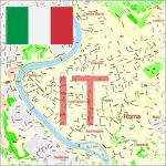 Italy Cities and Country Vector Maps in Adobe Illustrator, PDF and other vector formats
For publishing, design, printing, media, publications, arts, projects, presentations, for architects, designers and builders, business, logistics.
Spain Cities and Country Vector Maps
 Spain Cities and Country Vector Maps in Adobe Illustrator, PDF and other vector formats
For publishing, design, printing, media, publications, arts, projects, presentations, for architects, designers and builders, business, logistics.
Russia Cities and Country Vector Maps in Adobe Illustrator, PDF and other vector formats
Карты городов России в векторных форматах, готовые и на заказ
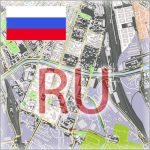 Russia Cities and Country Vector Maps in Adobe Illustrator, PDF and other vector formats. Карты городов России в векторных форматах, готовые и на заказ
For publishing, design, printing, media, publications, arts, projects, presentations, for architects, designers and builders, business, logistics.
Карты городов России в слоях, очень подробные, со всеми именами улиц, просты и удобны в редактировании.
Mexico Cities and Country Vector Maps in Adobe Illustrator, PDF and other vector formats
Mapas de vectores de ciudades y países de México en Adobe Illustrator, PDF y otros formatos de vectores
 Mexico Cities and Country Vector Maps in Adobe Illustrator, PDF and other vector formats
Mapas de vectores de Ciudades y países de México en Adobe Illustrator, PDF y otros formatos de vectores
For publishing, design, printing, media, publications, arts, projects, presentations, for architects, designers and builders, business, logistics.