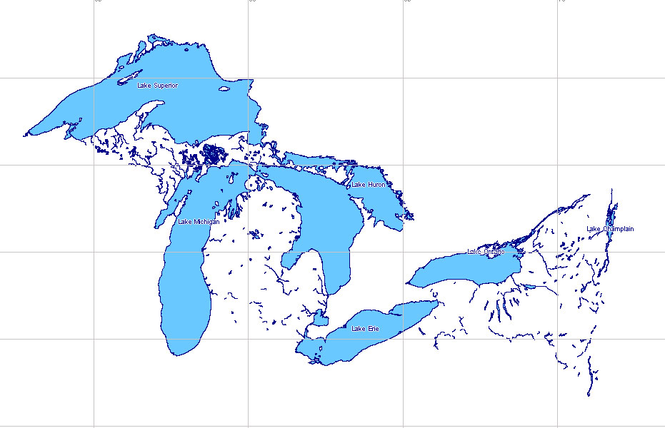
This is the full map (shapefiles in zip archive) of the GREAT LAKES – US and CA
Water File – Lakes and Rivers (polygons) – 2020
This set of shapefiles was created on August 12, 2020, based on open map data, and corrected from satellite images in the MapEdit (geopainting.com) software.
You can use it in any project without any limitations.
We will be grateful if you put a link to this page, or share it on social networks.
See also: Full version Vector Maps of the Greal Lakes Area High Detailed, US – CANADA, High Detailed, Adobe illustrator and PDF
List of the files in this archive:
- great_lakes_us_ca.prj
- great_lakes_us_ca.cpg
- great_lakes_us_ca.dbf
- great_lakes_us_ca.shp
- great_lakes_us_ca.shx
Great Lakes Shapefile (free download) = 64 MB ZIP download now >>>
Great Lakes Shapefile (free download) = 64 mb ZIP
Great lakes (USA, Canada)
Great Lakes (USA, Canada) include a group of 5 lakes in Eastern North America, in the St. Lawrence river basin:
- Superior (area-82,400 km2, maximum depth-393 m),
- Huron (59,600 km2, 208 m),
- Michigan (58,000 km2, 281 m),
- Erie (25,700 km2, 64 m),
- Ontario (19,500 km2, 236 m).
Lake Michigan is located in the United States, and other lakes and short rivers connecting them form the border between the United States and Canada.
Canada owns part of the water area of 4 lakes. The Great Lakes have a total coastline length of about 18,000 km, and the area of the water mirror is 245,200 km2.
The area of the Great Lakes basin is estimated at 768,000 km2 (including the area of the lakes themselves). The volume of water is about 22,725 km3. The Great Lakes are located in stages, the difference in height of lakes Superior, Huron, Michigan, and Erie does not exceed 9 m, and the only lake Ontario is almost 100 m below lake Erie. The lakes are connected by relatively short but multi-water rivers: lake Superior and Lake Huron by the St. Marys River (112 km long), Lake Huron and Lake Erie by the St. Clair River (43 km long) and lake St. Clair (1,275 km2) by the Detroit River (51 km long), lake Erie and lake Ontario by the Niagara River (54 km long), which forms Niagara falls (about 50 m high).
Lake Huron and Lake Michigan are connected by the Strait of Mackinac about 3 km wide.
Several hundred small rivers flow into the Great Lakes; the flow from the lakes is via the St. Lawrence River, which flows out of Lake Ontario and flows into the Atlantic ocean. The average flow rate at the source is about 6640 m3 / sec. The waters of the Great Lakes have low mineralization (from 0.06 to 0.13 g/l). The lakes are home to more than 170 species of fish (carp, perch, salmon, whitefish, trout, etc.).The Great Lakes are bordered on the South and Southeast by densely populated industrial areas, and on the North and West by agricultural and raw material areas of the United States and Canada. On the Great Lakes are the largest cities in the United States-Chicago and Milwaukee on the shores of Lake Michigan, Buffalo, and Cleveland – lake Erie, Detroit on the banks of the river of the same name – as well as the second-largest city in Canada – Toronto on the shores of Lake Ontario. The great lakes are connected to the Mississippi river basins by a system of navigable channels starting at Chicago and the Hudson River by a canal originating from lake Erie.
The Great Lakes basin is one of the world’s largest catchment systems and contains 18% of the world’s freshwater. The rate of water renewal in lakes is less than 1 % per year due to precipitation, surface, and underground runoff. Large-scale use of water resources in the United States and the developed part of Canada has led to serious environmental and socio-economic problems, primarily-pollution of surface and underground water. The US economy began to develop especially intensively after world war II, when there was an unprecedented growth of the industry. Industrial, household, and other wastewater without treatment to water bodies. In the lakes, the oxygen content significantly decreased, and fish began to die. The concentration of mercury, pesticides, and other pollutants was many times higher than the legal limit. The use and discharge of toxic chlorine-containing compounds (DDT, PCBs) and synthetic fertilizers into water systems led to their entry into the food chain. At the end of 1960, 40 % of the US water systems could not be used for fishing and swimming due to water pollution. At the same time, large volumes of pollutants were discharged into the Great lakes. In particular, in the early 1970s, lake Erie became virtually “dead” due to intense pollution.
Until the beginning of 1970, the lakes were polluted with harmful substances due to insufficient treatment of industrial wastewater, receipt of fertilizers and waste from surface runoff. Thus, during this period, the waters of lake Erie were marked by an excess of phosphorus, algae blooms, and a decrease in the fish population. Indigenous (local) communities of living aquatic organisms were particularly affected.
Moving away from the topic (Great Lakes), we note that the main legal basis for cooperation on water issues between Canada and the United States is the framework agreement between the United States and Canada on border waters of 1909, and the main structure is the American – Canadian international joint Commission (IOC) on border waters. The IOC consists of representatives from Canada and the United States and has the authority to assess the quantitative and qualitative state of watersheds along the international border. For example, another Treaty (from 1944) States that “border waters are an invaluable resource belonging to the peoples of Canada and the United States“, and that the governments of both countries “are responsible for managing these resources and ensuring a safe and plentiful supply of clean water”.
The Commission has broad powers.
The border waters Treaty between the United States and Canada of 1909 has been successfully implemented to date and, depending on the situation, the umbrella Treaty is supplemented with new provisions. Brief information about the Commission is of interest.
Article VII Of the Treaty of 1909 provides for the creation and maintenance of a permanent Canadian-American International joint Commission (ICC), consisting of 6 members on a parity basis – 3 from each Side.
The Commission is not an organ of the government, and the members of the Commission do not represent the governments that appointed them, do not receive instructions from them, and are not accountable to them, i.e. they are independent in making decisions.
Article XII of the Treaty obliges members of the Commission to perform their duties impartially. The independence of the Commission’s members is also confirmed by the Commission’s immunity from legal proceedings in both countries. In fact, members of the Commission can only be deprived of their powers by an Agreement between the two countries.
The Commission functions as a collegial body in the interests of both countries.
The Commission has a number of advantages, first of all it is not a body for negotiations between the governments of the Parties, and this avoids the disadvantages of this process. The Commission is obliged to be impartial in the study of the issues and find solutions that are competitive on national interests.
Parity of membership guarantees the equality of the parties involved, and the permanent functioning of the Commission frees It from instructions from the governments of the Parties to make a decision, which would be required in the event of a trial, and from political pressure. The bilateral Commission’s mandate is helping her to avoid the procedure of settlement of disputes with third parties.
The main task of the Commission is to prevent and resolve disputes between Canada and the United States. In order to achieve its goals, the Commission performs the following 3 main functions:
– The first function is pseudo-judicial.
The Commission has the right to manage applications for any new use, barrage or withdrawal of water in one country that is expected to change the natural water level or volume of runoff in another country. In order to make decisions, the Commission usually pre-creates a Council to advise on problems that arise on the issue under consideration;
– The second – Advisory.
The Commission has the authority to manage applications for the construction of any structures, dams or other barriers on rivers if these projects raise the natural water level on the other side of the border in the country upstream.
To make decisions on Advisory functions, the Commission also creates a Council to advise on issues under consideration.
The Commission’s decisions on the first two functions (pseudo-judicial and Advisory) are final and binding;
– The third function is arbitration.
The Commission considers any dispute referred to it by the governments of the Parties. The advice and consent of the us Senate is required before the US government can begin this legally binding arbitration process.
For 100 years, the Commission has not been referred to a single case on this issue.
The applicable international law for the water resources of the border region between the United States and Canada is also established in accordance with the provisions of The Treaty of 1909.
Thus, when the Commission is asked to approve a project on border waters, it applies the rules and principles set out in the Contract. The Commission may also apply other relevant rules of the MP. But in cases, the Commission has generally been guided by the principles agreed between governments, which leaves little room for the application of other rules of MP.
Decisions taken by the Commission require agreement with at least 4 members of the Commission to ensure that agreement can only be reached if at least one member from one country agrees with the decision.
In practice, almost all decisions are made on the basis of consensus, and this fact is considered by many experts to be an undoubted achievement. Equality of membership could theoretically lead to an equal division of opinion and create a deadlock. However, over the course of 100 years, the opinions of the Commission members were divided along national lines only in two cases out of 117, but even in these cases agreement was reached.
Another feature of the Commission’s procedures is the joint investigation.
As indicated above, in pseudo-judicial and Advisory cases, the Commission creates Advisory Councils consisting of an equal number of members from each country, representing Federal, provincial or state organizations, or the private sector. There is an unspoken rule that a member of the Council acts on the basis of professional and personal qualities, and not as a representative of their government or organization. Like the Commission, the Councils seek to work on the basis of consensus. This method of joint consideration of disputed issues of interstate relations is more reliable and effective than any other used in the settlement of disputes by a third party or in negotiations.
A joint investigation is the most important element in achieving consensus, both within the Commission and among the communities that may be affected by its decision. However, the relevant provisions of the Contract oblige the Commission to provide the parties with an “opportunity to be heard” in any proceedings. To this end, the Commission conducts public hearings and invites and supports the participation of provincial, state, and municipal governments when considering cross-border issues.
In 1970 The IOC published a report on the pollution of the ” lower” Great lake.
The Commission’s report (from 1970) became the basis for the conclusion of the 1972 Agreement on water quality in the Great lakes and coordinated actions to restore it.
Since 1972, the private and public sectors have spent more than 500 billion USD for the control and treatment of wastewater, mainly municipal and industrial point sources of pollution. In 1972 Canada and the United States have begun systematic work to clean up the Great lakes, resulting in a sharp reduction in the discharge of pollutants from land-based point sources. In the future, the 1972 Agreement was supplemented in accordance with the current situation. So, in 1978 the Agreement included provisions on the need for an ecosystem approach to environmental protection and the need to combat persistent chemical pollutants.
In 1987, the main directions of environmental policy were to reduce the phosphate load, pollution from the air and land, as well as to solve problems related to pollution of bottom sediments (to reduce secondary pollution) and groundwater. In the same year, action Plans were developed to clean up the previously identified 43 environmentally problematic territories and large-scale work was initiated to implement the action Plans. Accordingly, the discharge of the number of persistent toxic chemical pollutants into lakes has been reduced.
Since 1972, there has been a 71% decrease in the production, use, and discharge of 7 major toxic compounds with wastewater. Since the end of 1980, we have managed to reduce the volume of toxic substances by 82 %. As a result of a sharp reduction in the intake of phosphorus and other pollutants, the development of algae in Lake Erie has significantly decreased and the oxygen deficit in the bottom layer has decreased. The previously declared “dead” lake has become the world’s largest bass fishing area.
However, in the 1990s, rapid urban and industrial development continued to damage the environment in the lake catchments. Up to one thousand types of toxic pollutants have been detected in the Great lakes, which get there along with sewage and acid rain. The problem of acid rain remains one of the most acute, about 50% of acid rain in Canada comes from the United States. It was also found that up to 96 % of the chlorine-containing chemical compounds in the waters of the Great lakes come from the atmosphere. Perhaps this is why Canada was the first signatory to the Kyoto Protocol on regulating greenhouse gas emissions and introduced a mandatory reporting system for industrial enterprises on the amount of greenhouse gases released into the atmosphere. At the same time, the US has not signed the Kyoto Protocol.
To solve the problem, in the first half of 1990, the United States and Canada developed a Strategy to protect the Great lakes from toxic pollution, which began to be implemented in 1997. The strategy includes activities related to the replacement of highly toxic chemicals in industrial cycles with low-toxic ones, with the phasing out of substances that pose a risk to human health and the environment. According to experts, the Strategy makes a significant contribution to reducing and eliminating the content of toxic chemicals in the ecosystem of the Great lake.
Most experts highly appreciate the joint efforts of the United States and Canada aimed at improving the quality of the Great lakes waters, and consider these to be an outstanding example of cooperation between both interstate and local water users.
Experts emphasize that serious progress has been made in improving the quality of natural water, especially surface water in the United States and Canada.
A number of experts consider the Commission’s achievements to be greatly exaggerated. So, in their opinion, despite the enormous efforts and material costs to reduce the pollution of the Great lakes, so far the concentration of mercury and a number of pesticides in some fish species is so high that their consumption is dangerous to health. The Commission’s latest reports also warn of slowing progress in addressing a number of issues – clearing sediments containing persistent toxic pollutants, and controlling invasive (“alien”) species of animals and plants entering lakes as “ballast cargo” of ocean vessels and other routes. The danger lies in their rapid reproduction in the absence of natural predators and other regulatory mechanisms to the detriment of their new habitat.
According to experts, the Great lakes, which remain the main source of freshwater in Canada, may face other environmental problems. For example, global warming may cause lake levels to fall by 1 m by the middle of the XXI century, which may lead to serious environmental consequences. Lack of water may raise the issue of the need to transfer part of the river flow or to withdraw lake water, which poses a threat to the sustainable use of water resources.
Experts believe that frequent droughts and floods, and the catastrophic decline in water supplies in the Great lakes are the main challenges for the Northern part of the continent. The increasing shortage of freshwater in North America already costs the US and Canada tens of billions of USD annually.
According to experts, the frequency of major floods, which previously occurred every 500 years, will increase 10 times during the XXI century. The mid-and southwestern United States is subject to severe droughts, which lead to severe soil degradation and reduced groundwater levels. Thus, the underground water reserves in the largest aquifer of Ogallala are reduced by 12 km3 annually, and further lowering of the groundwater level will cause water shortages in 8 us States.
The situation with water scarcity is directly related to anthropogenic activities. For example, water overflow during a series of droughts in the United States in the 1930s, when farmers, in order to somehow protect the soil from degradation and harvest, intensively pumped water from underground sources, affects to this day. A decrease in underground water resources leads to an increase in water consumption from surface sources, such as the Great lakes. Thus, in the United States, there is a debate about the possibility of transferring water resources from the Great Lakes to the Mississippi River to meet needs during the hot season.
At the same time, the intensification of agriculture and the growth of urban settlements and the population, in general, have led to a large-scale increase in diffuse pollution as a result of stormwater runoff from urban areas, washing away excess fertilizers, pesticides, herbicides and other chemicals from agricultural fields, pastures, and livestock complexes.
According to experts, this type of scattered pollution has become a new challenge for the last two decades of the twentieth century for the North American continent.
Over its 100 years of operation, the Commission has accumulated a wealth of practical experience in addressing issues related to the use of TVR and the environment.
In particular:
– in 1931. The Commission made recommendations to governments on measures to reduce emissions from the Trail smelter in British Columbia and proposed a formula for compensation for damage to the United States.
The Commission’s recommendations prevented a serious conflict;
– in 1944. The Commission was asked to investigate the use and development of the Columbia River, and in 1959 to develop recommendations on principles for distributing benefits in the lower reaches, especially with regard to hydropower and flood control.
The corresponding report of the Commission helped the governments of the United States and Canada to conclude in 1961 The agreement on the development of the Columbia river;
– in 1975 and 1985. The Commission, on behalf of the governments of the Parties, studied the issue and made recommendations on 2 projects proposed for implementation in the United States (the case of the water intake facility in the United States, Harrison, 1975) and Canada (the case of Flathead, 1985) regarding the possibility of violation of the provisions of The Treaty of 1909.
Both projects were rejected on the recommendation of the Commission;
– in 1998, the Canadian company received permission from the Ministry of Environment of Ontario to export water to Asia in the amount of 600 thousand m3/year from lake Superior.
However, after the Canadian Foreign Ministry asked the US to consider this issue by the Commission, the Canadian company had to abandon the commercial transaction.
In this context, in 2001, Canada passed a law prohibiting mass water abstractions from the Great lakes and other border rivers and lakes.
These and other examples illustrate the complexity and contentious nature of the issues before the Commission. But they also show that the Commission, with its powers and a single mandate, can effectively organize its work, especially in the settlement of disputed issues on transboundary waters. As for the issue of water allocation, the 1909 Treaty defines it on the basis of equal distribution of benefits, determined mainly by the production of hydroelectric power.
In General, experts believe that the Canada–US border Commission can serve as a good example in managing transboundary water resources. However, experts attribute one of the main reasons for the success of the Commission to the fact that problems related to the use of transboundary water resources and environmental protection were traditional issues that were within the competence of the Commission.
US MAP CATALOG BY STATE NAME: you can see all maps of the cities and counties by click on the name of state
 Alabama AL
 ![]() Alaska AK
Alaska AK ![]() Arizona AZ
Arizona AZ ![]() Arkansas AR
Arkansas AR ![]() California CA
California CA ![]() Colorado CO
Colorado CO ![]() Connecticut CT
Connecticut CT
![]() Delaware DE
Delaware DE  District Columbia DC
 ![]() Florida FL
Florida FL ![]() Georgia GA
Georgia GA ![]() Hawaii HI
Hawaii HI ![]() Idaho ID
Idaho ID ![]() Illinois IL
Illinois IL
![]() Indiana IN
Indiana IN ![]() Iowa IA
Iowa IA ![]() Kansas KS
Kansas KS ![]() Kentucky KY
Kentucky KY ![]() Louisiana LA
Louisiana LA ![]() Maine ME
Maine ME ![]() Maryland MD
Maryland MD
![]() Massachusetts MA
Massachusetts MA ![]() Michigan MI
Michigan MI ![]() Minnesota MN
Minnesota MN ![]() Mississippi MS
Mississippi MS ![]() Missouri MO
Missouri MO ![]() Montana MT
Montana MT ![]() Nebraska NE
Nebraska NE
![]() Nevada NV
Nevada NV ![]() New Hampshire NH
New Hampshire NH ![]() New Jersey NJ
New Jersey NJ ![]() New Mexico NM
New Mexico NM ![]() New York NY
New York NY ![]() North Carolina NC
North Carolina NC
![]() North Dakota ND
North Dakota ND ![]() Ohio OH
Ohio OH ![]() Oklahoma OK
Oklahoma OK ![]() Oregon OR
Oregon OR ![]() Pennsylvania PA
Pennsylvania PA ![]() Puerto Rico PR
Puerto Rico PR
![]() Rhode Island RI
Rhode Island RI ![]() South Carolina SC
South Carolina SC ![]() South Dakota SD
South Dakota SD ![]() Tennessee TN
Tennessee TN ![]() Texas TX
Texas TX ![]() Utah UT
Utah UT
![]() Vermont VT
Vermont VT ![]() Virginia VA
Virginia VA ![]() Washington WA
Washington WA ![]() West Virginia WV
West Virginia WV ![]() Wisconsin WI
Wisconsin WI ![]() Wyoming WY
Wyoming WY