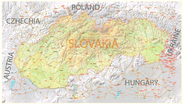
Slovakia is a landlocked country located in Central Europe. It is known for its picturesque landscapes, historical towns, and cultural heritage.
Vectormap.Net provide you with the most accurate and up-to-date vector maps in Adobe Illustrator, PDF and other formats, designed for editing and printing. Please read the vector map descriptions carefully.
Here’s a brief overview of some of the main cities and towns, as well as principal roads in Slovakia:
Main Cities and Towns:
- Bratislava:
- The capital and largest city of Slovakia.
- Located in the southwestern part of the country, near the borders with Austria and Hungary.
- Known for its historic Old Town, Bratislava Castle, and the Danube River.
- Košice:
- The second-largest city in Slovakia, situated in the eastern part of the country.
- Features a well-preserved historical center, St. Elisabeth Cathedral, and the Košice State Theater.
- Prešov:
- A city in eastern Slovakia with a rich history and cultural heritage.
- Notable landmarks include St. Nicholas Cathedral and the Orthodox St. Alexander Nevsky Cathedral.
- Žilina:
- Located in the northwestern part of Slovakia.
- Known for its medieval castle, churches, and the Budatín Castle.
- Nitra:
- One of the oldest cities in Slovakia, situated in the western part of the country.
- Features Nitra Castle, Agrokomplex exhibition center, and the historical Old Town.
Principal Roads:
- D1 Motorway:
- The major highway connecting Bratislava to Košice, passing through major cities like Trnava, Trenčín, Žilina, and Banská Bystrica.
- D2 Motorway:
- Connects Bratislava to the Czech Republic and Austria.
- R1 Expressway:
- Links Bratislava to Banská Bystrica, passing through Trnava and Nitra.
- I/18 Road:
- Connects Bratislava to Žilina, passing through Trnava and Trenčín.
- I/50 Road:
- Connects Košice to Zvolen, passing through Rožňava and Rimavská Sobota.
- I/64 Road:
- Connects Prešov to Poprad, traversing through various towns in the eastern part of Slovakia.
These are just a few examples, and Slovakia has an extensive road network connecting its cities and towns, making it relatively easy to explore the country by car. Additionally, the scenic landscapes and historical sites along these routes make road travel in Slovakia enjoyable.


 Author: Kirill Shrayber, Ph.D.