Extended Description of the Vector Map
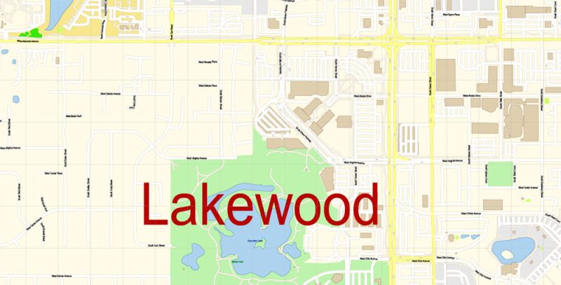
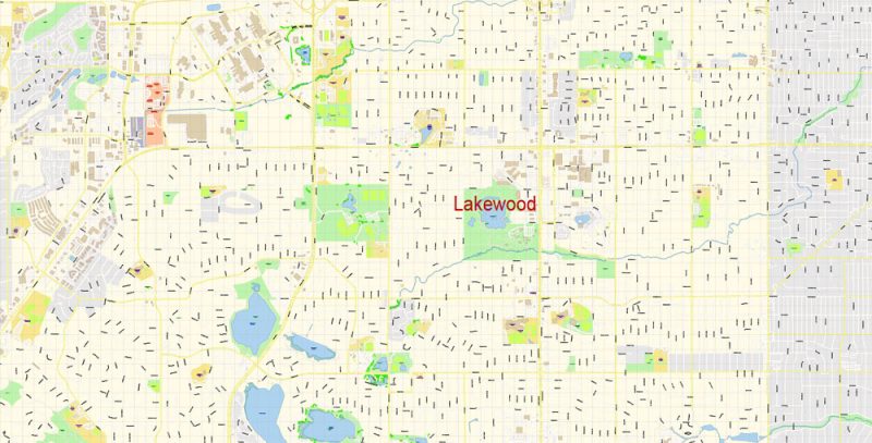
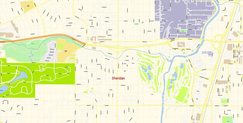
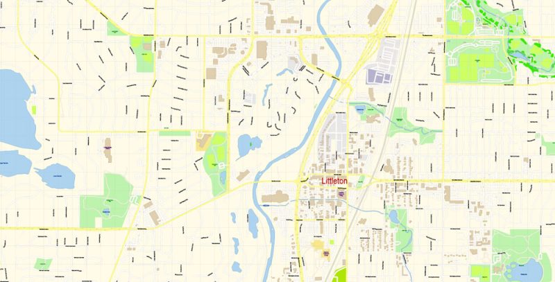
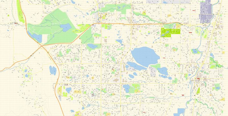
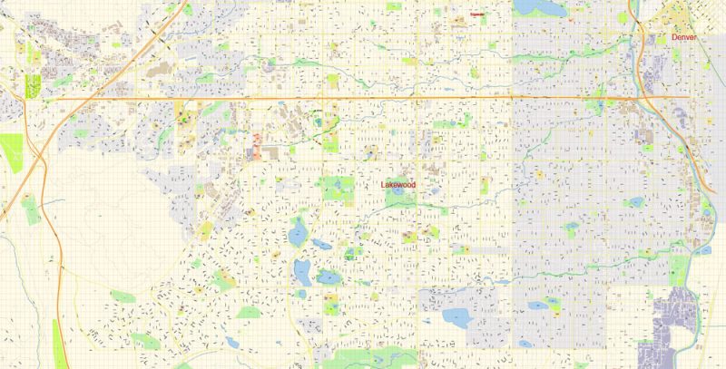
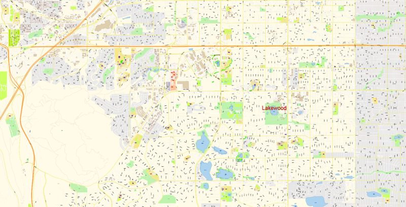
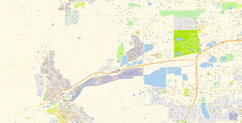
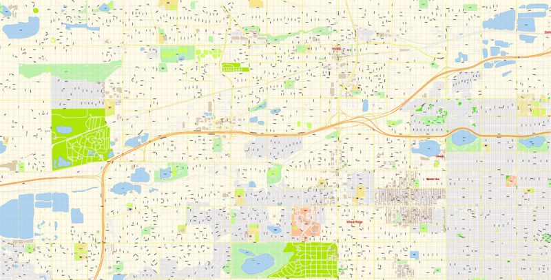
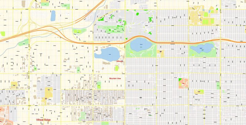
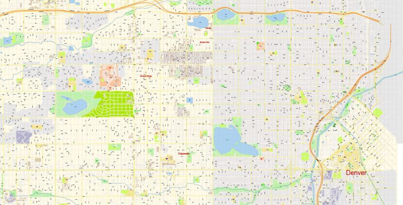
Printable PDF Vector Map of Lakewood Colorado US detailed City Plan scale 100 m 1:3614 full editable Adobe PDF Street Map in layers, scalable, text format all names, 71 MB ZIP
All street names, Main Objects, Buildings. Map for design, printing, arts, projects, presentations, for architects, designers, and builders, business, logistics.
Layers: color_fills, water, streets_roads, labels_roads, names_objects, names_streets, names_places, arrows_streets, buildings, legend, etc.
The most exact and detailed map of the city in scale.
IF YOU NEED: We can add the layer areas and numbers zip (postal) codes.
For Editing and High-Quality Printing
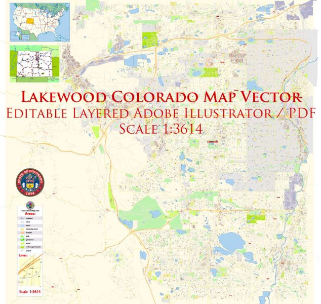
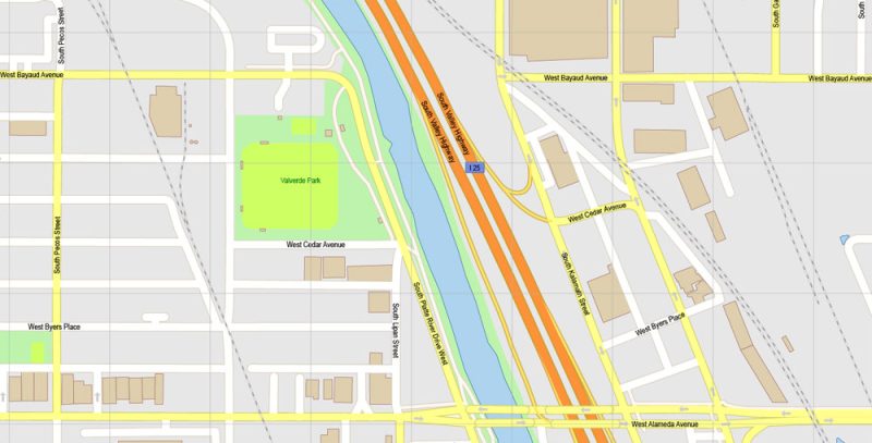
Lakewood Colorado US PDF Map Vector Exact State Plan High Detailed Street Map editable Adobe PDF in layers
All about Colorado
Colorado is considered one of the natural wonders of the world. Therefore, tourists from all over the globe tend to come here.
The state of Colorado is located in the West Central part of the United States. Colorado (Spanish for “red”) owes its name to the beautiful mountain landscape. Founded on August 1, 1876, exactly 100 years after the formation of the United States, Colorado became the 38th state of America. Because of this fact, one of the Mountain States of America is also called the “State of the century” (Centennial State). Colorado borders seven other States: Wyoming and Nebraska (to the North), Oklahoma, New Mexico, and Arizona (to the South), Utah (to the West), and Kansas (to the East).
Lakewood Colorado US PDF Map Vector Exact State Plan High Detailed Street Map editable Adobe PDF in layers
The Colorado state flag, adopted in 1911, is a rectangle with blue and white stripes that symbolize the state’s skies and snow. The red letter “C” stands for the state name “Colorado”. Inside the letter “C” is a Golden ball, which symbolizes the gold mines of the state. The coat of arms of the state has a circular shape. It depicts an all-Seeing Eye, enclosed in a triangle, symbolizing the Trinity. Also on the coat of arms depicts the mountains of Colorado, earth, and pickaxe, which symbolize the mining industry. Below flaunts the motto of the state – “Nil sine numine”, which translated from Latin means “Nothing without Providence.” The coat of arms was officially adopted in 1877.
Lakewood Colorado US PDF Map Vector Exact State Plan High Detailed Street Map editable Adobe PDF in layers
Geography
The geography of Colorado is distinguished by its diversity. High mountains, arid plains, huge sand dunes, deep canyons, sandstone, granite, rivers, lakes and dense forests – in this state mixed all the colors known to nature. Therefore, Colorado is called a “multicolored” state. The boundaries of Colorado are initially defined along the latitude and longitude lines and form a quadrilateral that is located from 37 ° to 41 ° North latitude and from 102 ° 03′ to 109 ° 03′ West longitude. Colorado, Wyoming, and Utah are three States that have boundaries defined solely by latitude and longitude lines.
Lakewood Colorado US PDF Map Vector Exact State Plan High Detailed Street Map editable Adobe PDF in layers
Climate
Since Colorado is one of the Mountainous States, the climatic conditions are quite difficult. Southern Colorado isn’t always warmer than northern Colorado. Most of the state is covered by mountains, foothills, and high plains. Mountains greatly affect the local climate. As a rule, with increasing height, the temperature decreases, and the humidity increases. In the East, the climate is temperate continental: low humidity, moderate precipitation (380-630 mm per year). It is marked by one of the highest average daily temperatures in the United States. In summer the temperature rises to 35 °C (average) and in winter it can drop to -18 °C. The climate of Western Colorado is more uniform. Here there are arid places on the hills of the mountain climate. The hottest month is July (21 °C). Winter here is very wet, which is the opposite of the Eastern part of the state.
Lakewood Colorado US PDF Map Vector Exact State Plan High Detailed Street Map editable Adobe PDF in layers
Facts about Colorado
- The area of the state 269 837 km2 (8th largest in the United States)
- Latitude 37°0′ North latitude. at 41°0′ N., 612 km
Longitude 102°8′ W. d. 109°0′ W. d., 451 km
- Length from North to South – 451 km, from East to West – 612 km
- The highest point is 4 401 meters above sea level
The lowest point is 1,011 meters above sea level
- Water surface 0.36 %
- Date of formation August 1, 1876 (38 in the United States)
Before the adoption of the status of the territory of Colorado
- Population 5 187 582 people, data for the year 2012 (ranked 22nd in the USA)
- Population density of 19 persons/km2 (37th place in the United States)
- Mountain time zone VGM-7/-6 (Mountain Time Zone UTC-07:00)
- The abbreviation CO
- The Capital Is Denver
- The largest city Denver
- Major cities of Colorado Denver, Colorado Springs, Boulder, Fort Collins, Arvada, Pueblo, Westminster
- Motto Nil sine numine (“Nothing without Providence”)
- Nicknames “State of the century”, “American Switzerland”, “Mountain state”
- The legislature, the General Assembly Colorado
- Upper house state Senate
- The lower chamber, the House of representatives
- Official site www.colorado.gov
Lakewood Colorado US PDF Map Vector Exact State Plan High Detailed Street Map editable Adobe PDF in layers
Symbols of Colorado
Tree Colorado blue spruce (Picea pungens) state Flower Colorado Columbine blue (Aquilegia caerulea) is the state Animal of Colorado is the bighorn sheep (Ovis canadensis, bighorn sheep) Bird of Colorado – Lark Bunting (Calamospiza melanocortins) Fish of Colorado – the Clark salmon (Oncorhynchus clarki somias) Butterfly of the state of Colorado Hypaurotis cysaluswas state Gemstone for Colorado is the aquamarine Mineral of Colorado – rhodochrosite
Dance of Colorado, square dance
Lakewood Colorado US PDF Map Vector Exact State Plan High Detailed Street Map editable Adobe PDF in layers
Lakewood Colorado US PDF Map Vector Exact State Plan High Detailed Street Map editable Adobe PDF in layers
Lakewood Colorado US PDF Map Vector Exact State Plan High Detailed Street Map editable Adobe PDF in layers
Lakewood Colorado US PDF Map Vector Exact State Plan High Detailed Street Map editable Adobe PDF in layers
Lakewood Colorado US PDF Map Vector Exact State Plan High Detailed Street Map editable Adobe PDF in layers
Lakewood Colorado US PDF Map Vector Exact State Plan High Detailed Street Map editable Adobe PDF in layers
Lakewood Colorado US PDF Map Vector Exact State Plan High Detailed Street Map editable Adobe PDF in layers


 Author: Kirill Shrayber, Ph.D. FRGS
 editable Adobe Illustrator in layers")


