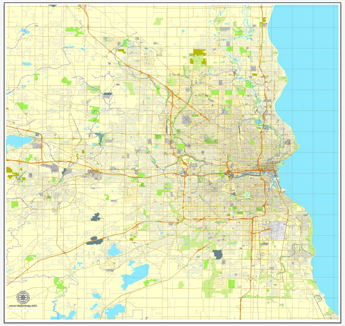
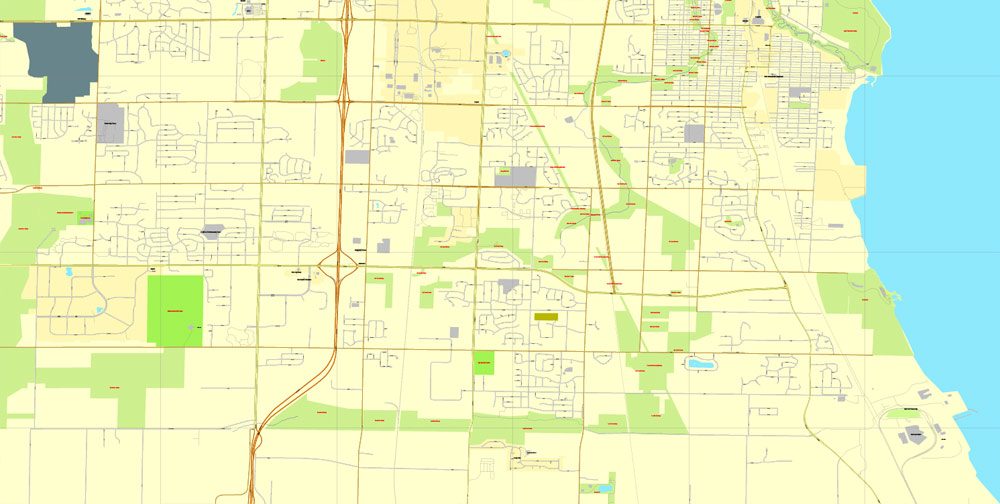
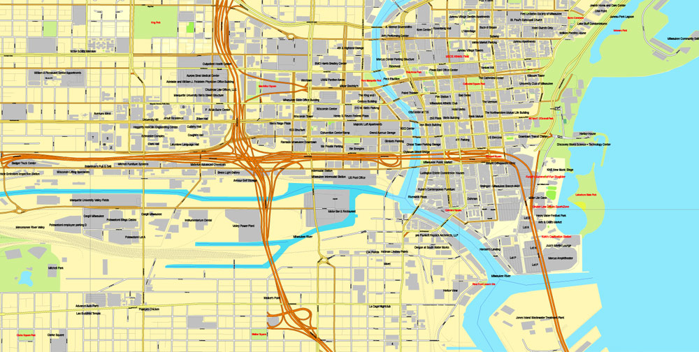
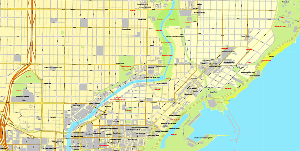
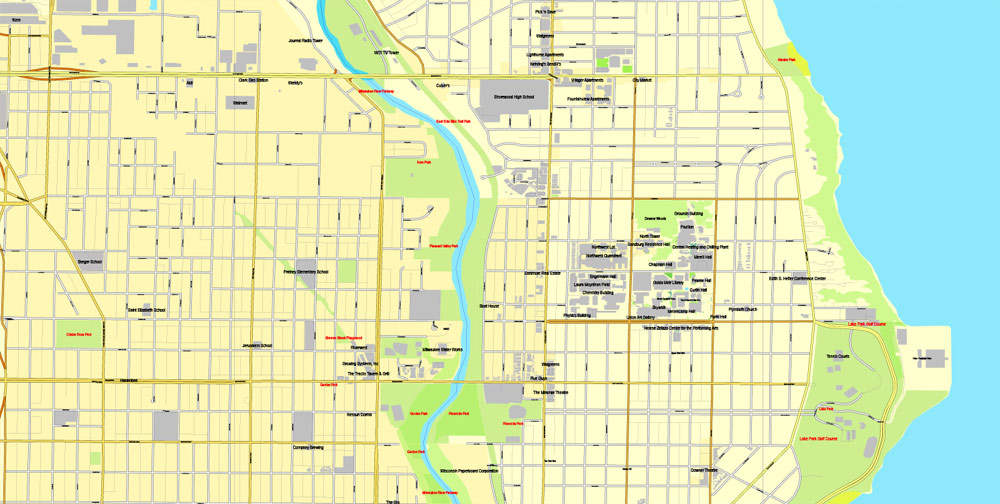
Milwaukee, Wisconsin, US, vector map Adobe PDF editable City Plan V3, full vector, scalable, printable, text format street names, 24 mb ZIP
All streets, Some more buildings. Map for design, printing, arts, projects, presentations, for architects, designers and builders.
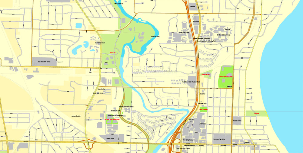
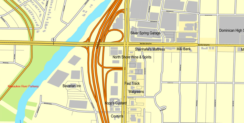
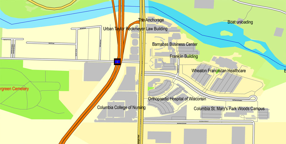
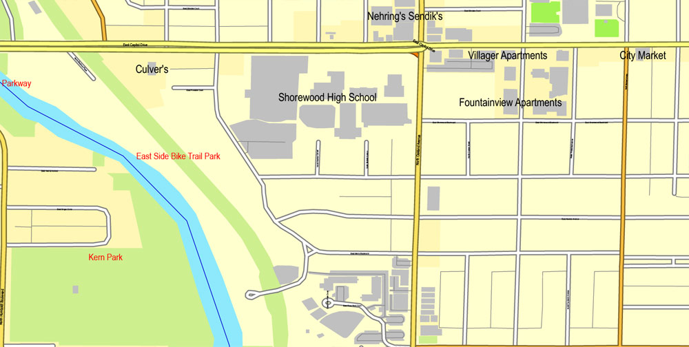
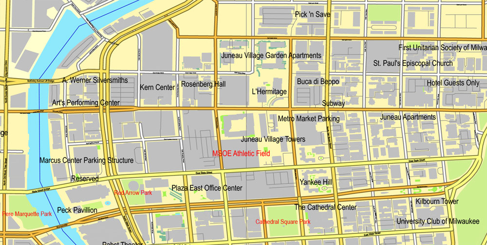
The most accurate and detailed map of the city.
CDR, DWG, DXF and other formats – on demand, same price, please, contact
Milwaukee, Wisconsin, USA.
This vector map of Milwaukee city is used as a basis for design, editing, and further printing.
This is the most detailed, exact map of Milwaukee city for high-quality printing and polygraphy. You can always clarify the map development date by contacting us.
For your convenience, all objects on Milwaukee vector city map are divided into layers. And the editing is very easy – colors, lines, etc.
You can easily add any objects needed (e.g. shops, salons, sale points, gas station or attraction) on any layer of Milwaukee vector map.
Milwaukee is the largest city in the state of Wisconsin and the fifth-largest city in the Midwestern United States. The seat of the eponymous county, it is on Lake Michigan’s western shore. Ranked by estimated 2014 population, Milwaukee was the 31st largest city in the United States. The city’s estimated population in 2017 was 595,351. Milwaukee is the main cultural and economic center of the Milwaukee metropolitan area. It is also part of the larger Milwaukee-Racine-Waukesha combined statistical area, which had an estimated population of 2,026,243 in the 2010 census. Milwaukee is the second-most densely populated metropolitan area in the Midwest, surpassed only by Chicago.
One of the advantages of Milwaukee city vector maps of our production is the relevance of cartographic data, we constantly update all our products.
This vector map of Milwaukee city is used by:
designers, layout designers, printers, advertisers and architects. Our product – vector maps – is designed for further editing and printing in large formats – from @Wall format (a few meters) to A-0 and A-1, A-2, A-3.
The Milwaukee city map in vector format is used for design, urban planning, presentations and media visualizations.
The advertising and presentation map of Milwaukee city (usually the final designer marks the routes, and puts the client’s objects (shops, saloons, gas stations etc.)
The undoubted advantage is that people will NEVER throw out this advertising product – the map. In fact, as an advertising medium, a city map is the most “long-playing” of the well-known polygraphic advertising media, with the longest lifespan, and the maximum number of interactions with the customer.
For travelers, maps are sold at the airports and gas stations around the world. Often the source is our vector maps.
Take a look, who purchases our vector maps of Milwaukee city in “Our Clients and Friends” page – these are large and small companies, from super-brands like Volvo and Starbucks, to small design studios and printing houses.
It’s very easy to work with vector maps of Milwaukee city, even for a not very experienced designer who can turn on and off the map layers, add new objects, change the colors of fill and lines according to customer requirements.
Geography
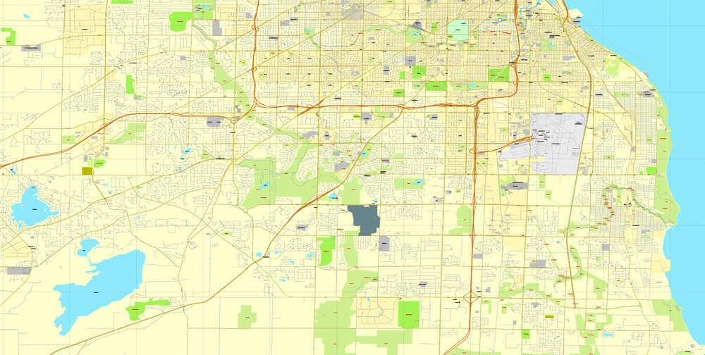
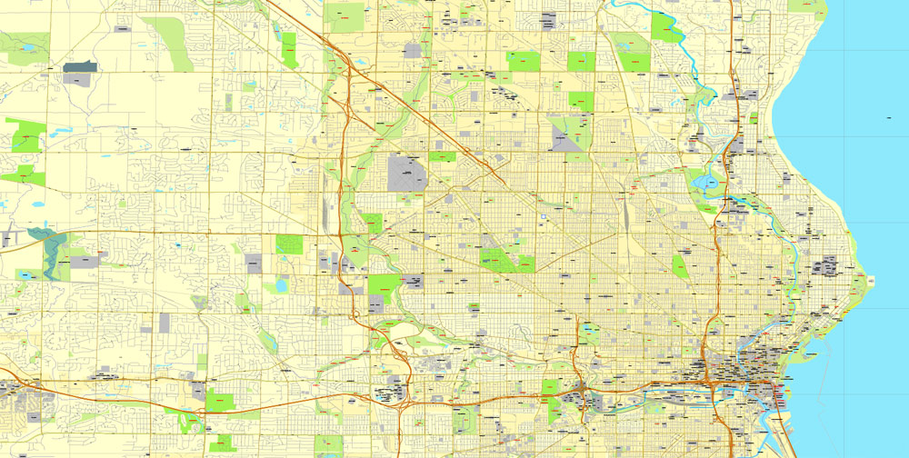
Milwaukee lies along the shores and bluffs of Lake Michigan at the confluence of three rivers: the Menomonee, the Kinnickinnic, and the Milwaukee. Smaller rivers, such as the Root River and Lincoln Creek, also flow through the city.
The undoubted advantage of Milwaukee city vector maps in printing is an excellent and detailed visualization, when customer can expand a large paper map and instantly define his location, find a landmark, an object or address on map, unlike using the popular electronic formats of Google and Yandex maps for example.
Printable vector maps of Milwaukee city are much more convenient and efficient than any electronic maps on your smartphone, because ALL DETAILS are displayed in the entire space of Milwaukee city map.
Useful tips on working with vector maps of cities and countries in Adobe Illustrator.
«V» – launches the Selection tool (cursor, black arrow), which makes active any vector line.
«А» – launches the Direct Selection tool (white cursor), allows you to select curve elements and drag them to the desired place.
«R» – activates the Rotate tool, which helps you rotating selected objects around the center point by 360 degrees.
«E» – gives you the opportunity to use the Eraser tool and erase unnecessary parts.
«X» – switches between Fill and Stroke in the Tools section. Try to get used to this hot key and
you will quickly understand that you can’t live and work without it.
Guides are not limited to vertical and horizontal in Adobe Illustrator. You can also create a diagonal guide for example. Moreover, you can turn any contours into guides. Select the outline and go to View > Guides > Make Guides (Create Guides), or simply press Cmd/Ctrl + 5. You can also turn the guides back into an editable object. Go to menu, View > Guides > Unlock Guides (Release Guides), select the guide you want to edit and select View > Guides > Release Guides (Reset Guides), or just press Cmd/Ctrl + Option / Alt + 5).
You will probably want to change the color scheme used on our Milwaukee vector city map.
To quickly and effectively play with colors.
Of course, you can do it manually, all objects in our Milwaukee city vector map are divided according to types and layers, and you can easily change the color gamma of vector objects in groups and layers.
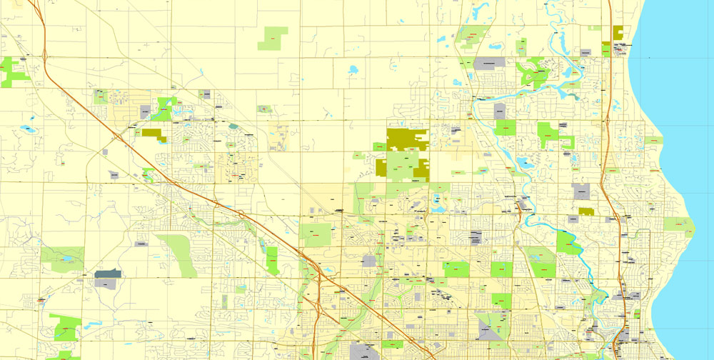
Milwaukee’s terrain is sculpted by the glacier path and includes steep bluffs along Lake Michigan that begin about a mile (1.6 km) north of downtown. In addition, 30 miles (48 km) southwest of Milwaukee is the Kettle Moraine and lake country that provides an industrial landscape combined with inland lakes.
One of the advantages of Milwaukee city vector maps of our production is the relevance of cartographic data, we constantly update all our products.
This vector map of Milwaukee city is used by:
designers, layout designers, printers, advertisers and architects. Our product – vector maps – is designed for further editing and printing in large formats – from @Wall format (a few meters) to A-0 and A-1, A-2, A-3.
The Milwaukee city map in vector format is used for design, urban planning, presentations and media visualizations.
The advertising and presentation map of Milwaukee city (usually the final designer marks the routes, and puts the client’s objects (shops, saloons, gas stations etc.)
The undoubted advantage is that people will NEVER throw out this advertising product – the map. In fact, as an advertising medium, a city map is the most “long-playing” of the well-known polygraphic advertising media, with the longest lifespan, and the maximum number of interactions with the customer.
For travelers, maps are sold at the airports and gas stations around the world. Often the source is our vector maps.
Take a look, who purchases our vector maps of Milwaukee city in “Our Clients and Friends” page – these are large and small companies, from super-brands like Volvo and Starbucks, to small design studios and printing houses.
It’s very easy to work with vector maps of Milwaukee city, even for a not very experienced designer who can turn on and off the map layers, add new objects, change the colors of fill and lines according to customer requirements.
Geography
Milwaukee lies along the shores and bluffs of Lake Michigan at the confluence of three rivers: the Menomonee, the Kinnickinnic, and the Milwaukee. Smaller rivers, such as the Root River and Lincoln Creek, also flow through the city.
The first Europeans to pass through the area were French Catholic Jesuit missionaries, who were ministering to Native Americans, and fur traders. In 1818, the French Canadian explorer Solomon Juneau settled in the area, and in 1846, Juneau’s town combined with two neighboring towns to incorporate as the city of Milwaukee. Large numbers of German immigrants arrived during the late 1840s, after the German revolutions, with Poles and other eastern European immigrants arriving in the following decades. Milwaukee is known for its brewing traditions, begun with the German immigrants.
In the early 21st century, the city is undergoing its largest construction boom since the 1960s. Major new additions to the city in the past two decades include the Milwaukee Riverwalk, the Wisconsin Center, Miller Park, the Milwaukee Streetcar, an expansion to the Milwaukee Art Museum, Milwaukee Repertory Theater, and Pier Wisconsin, as well as major renovations to the UW–Milwaukee Panther Arena. The Fiserv Forum opened in late 2018.
One of the advantages of Milwaukee city vector maps of our production is the relevance of cartographic data, we constantly update all our products.
This vector map of Milwaukee city is used by:
designers, layout designers, printers, advertisers and architects. Our product – vector maps – is designed for further editing and printing in large formats – from @Wall format (a few meters) to A-0 and A-1, A-2, A-3.
The Milwaukee city map in vector format is used for design, urban planning, presentations and media visualizations.
The advertising and presentation map of Milwaukee city (usually the final designer marks the routes, and puts the client’s objects (shops, saloons, gas stations etc.)
The undoubted advantage is that people will NEVER throw out this advertising product – the map. In fact, as an advertising medium, a city map is the most “long-playing” of the well-known polygraphic advertising media, with the longest lifespan, and the maximum number of interactions with the customer.
For travelers, maps are sold at the airports and gas stations around the world. Often the source is our vector maps.
Take a look, who purchases our vector maps of Milwaukee city in “Our Clients and Friends” page – these are large and small companies, from super-brands like Volvo and Starbucks, to small design studios and printing houses.
It’s very easy to work with vector maps of Milwaukee city, even for a not very experienced designer who can turn on and off the map layers, add new objects, change the colors of fill and lines according to customer requirements.
Geography
Milwaukee lies along the shores and bluffs of Lake Michigan at the confluence of three rivers: the Menomonee, the Kinnickinnic, and the Milwaukee. Smaller rivers, such as the Root River and Lincoln Creek, also flow through the city.
But there is more effective way of working with the whole VECTOR MAP of Milwaukee city and all layers:
The overview dialog «Edit colors»/«Repaint Graphic Object» (this dialog box name can change depending on the context):
If you have selected a part or a layer of Milwaukee city vector map and open the dialog box by clicking the icon in the Control panel, on the Samples palette or the Color Catalog, or if you choose Edit > Edit Colors> Repaint Graphic Object, then the «Repaint Graphic Object» dialog box appears, and you get access to «Assign» and «Edit» tabs.
If a picture or a map fragment is not selected, and you open the dialog box by clicking the icon in the Control panel, on the Samples palette or in the Color Catalog, the «Edit Colors» dialog box appears and you can only access the «Edit» tab.
Regardless of the name at the top of the dialog box, the right-hand side always displays the color group of the current document, as well as two default color groups: Print Color and Grayscale. These color groups can be selected and used any time.
Create and edit color groups of Milwaukee city vector map, and also assign colors using the «Edit Colors»/ а «Repaint Graphic Object» dialog box.
A. Creating and editing of a color group on the «Edit» tab
B. Assigning colors on the «Assign» tab
C. Select a group of colors from the «Color groups» list
The option «Repaint a graphic object» in the lower part of the dialog box allows you to preview the colors on a selected layer of Vector map, or a group of elements, and specify whether its colors will be redefined when the dialog box is closed.
The main areas of the dialog box are:
«Edit»
The «Edit» tab is designed to create a new or edit the existing color groups.
The harmony rules Menu and the Color Wheel are used to conduct experiments with color harmonies. The color wheel shows how colors are related in color harmony, and the color bars allow you to view and manipulate an individual color values. In addition, you can adjust the brightness, add and remove colors, save color groups and view colors on the selected Vector Map of Milwaukee city or a separated layers.
«Assign»
The «Assign» tab is used to view and control on how the original colors are replaced with colors from the color group like your corporate colors in the Vector Map of Milwaukee city.
The assign color ability is provided only if the entire map, layer or fragment is selected in the document. You can specify which of new colors replace the current colors, whether the spot colors should be preserved and how colors are replaced (for example, you can replace colors completely or changing the color tone while maintaining the brightness). The «Assign» tab allows you to redefine colors in the Vector Map of Milwaukee city, or in separate layers and fragments using the current color group or reducing the number of colors in the current Vector Map.
Color groups
Is a list of all saved color groups for current document (the same groups appear in the «Samples» palette). You can edit and delete the existing color groups, as well as creating a new ones using the list of “Color Groups” in the dialog box. All changes appear in the «Samples» palette.
The highlighted color group shows, which color group is currently edited.
Any color group can be selected and edited, or used to redefine the colors in the selected vector map of Milwaukee city, its fragments or elements.
Saving a color group adds this group to the specified list.
Opening the «Edit Colors»/«Repaint Graphic Object» dialog box.
Open the «Edit Colors»/«Repaint Graphic Object» dialog box using one of the following methods:
«Edit»> «Edit Colors»> «Repaint Graphic object» or «Repaint With Style».
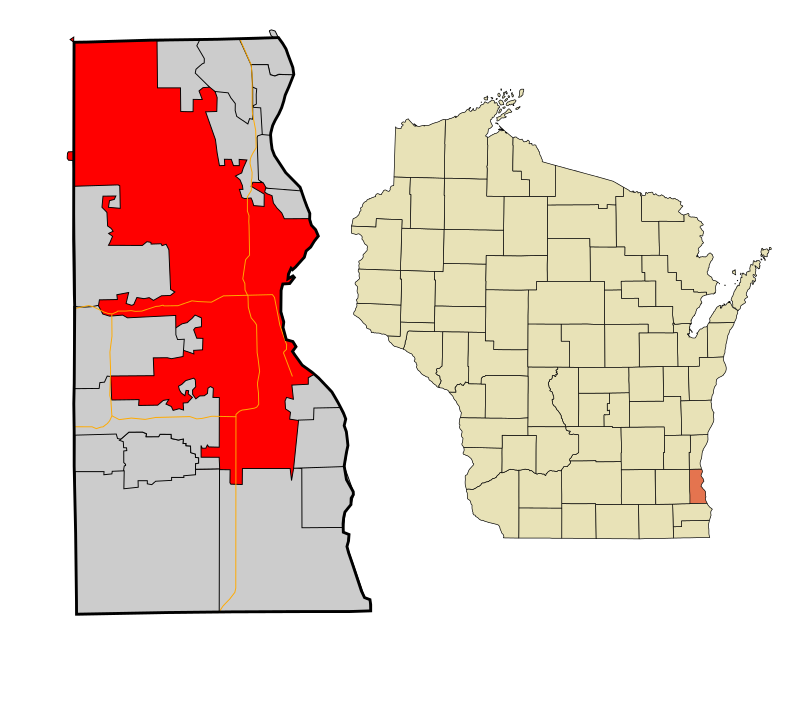
According to the United States Census Bureau, the city has a total area of 96.80 square miles (250.71 km2), of which, 96.12 square miles (248.95 km2) is land and 0.68 square miles (1.76 km2) is water. The city is overwhelmingly (99.89% of its area) in Milwaukee County, but there are two tiny unpopulated parts of it that extend into neighboring counties. The part in Washington County is bordered by the southeast corner of Germantown, while the part in Waukesha County is bordered by the southeast corner of Menomonee Falls, north of the village of Butler.
Use these commands if you need to edit the colors in the selected vector map of Milwaukee city.
«Repaint Graphic object» button on the «Control» panel.
Use this button if you need to adjust colors of Milwaukee city vector map using the а «Repaint graphic object» dialog box.
The specified button is available if the selected vector map or its fragment contains two or more colors.
Note. This color editing method is convenient for global color adjustment in a vector map, if global colors were not used when creating a City Map of Milwaukee.
The «Edit colors» button or «Edit or apply colors» on the «Color Catalog» palette
Click this button if you need to edit colors on the «Color Catalog» palette or edit and then apply them to the selected Vector Map of Milwaukee city or its fragment.
The «Edit color group» button or «Edit or apply color group» on the «Samples» palette.
Click this button if you need to edit the colors in the specific color group or edit and apply them to the selected Vector Map of Milwaukee city or a group of its elements, for example, the whole layer “Streets and lines”. You can also double-click the color group in the Samples panel to open the dialog box.
If the map file is too large and your computer freezes or even can’t open it quickly:
1. Try to reduce the color resolution of the video card (display) to 256 colors while working with a large map.
2. Using Windows Task Manager, select all the application you don’t need, while working with map, just turn them off.
3. Launch Adobe Illustrator. (DO NOT OPEN the vector map file)
4. Start the Windows Task Manager using administrator rights > Find the “Illustrator” process > set the «real time» priority,
5. Open the file. When you see the LEGACY FONT popup window – click “OK” (do not update). You can restore the TEXT later.
6. Can also be useful: When file is opened – Edit > Settings > Basic Settings > disable smoothing. /// It looks scary, but works quickly)))
We recommend saving the file in Adobe Illustrator 10 version. It’s much more stable when working with VERY BIG size files.
Cityscape
North-south streets are numbered, and east-west streets are named. However, north-south streets east of 1st Street are named, like east-west streets. The north-south numbering line is along the Menomonee River (east of Hawley Road) and Fairview Avenue/Golfview Parkway (west of Hawley Road), with the east-west numbering line defined along 1st Street (north of Oklahoma Avenue) and Chase/Howell Avenue (south of Oklahoma Avenue). This numbering system is also used to the north by Mequon in Ozaukee County, and by some Waukesha County communities.
Milwaukee is crossed by Interstate 43 and Interstate 94, which come together downtown at the Marquette Interchange. The Interstate 894 bypass (which as of May 2015 also contains Interstate 41) runs through portions of the city’s southwest side, and Interstate 794 comes out of the Marquette interchange eastbound, bends south along the lakefront and crosses the harbor over the Hoan Bridge, then ends near the Bay View neighborhood and becomes the “Lake Parkway” (WIS-794).
One of the distinctive traits of Milwaukee’s residential areas are the neighborhoods full of so-called Polish flats. These are two-family homes with separate entrances, but with the units stacked one on top of another instead of side-by-side. This arrangement enables a family of limited means to purchase both a home and a modestly priced rental apartment unit. Since Polish-American immigrants to the area prized land ownership, this solution, which was prominent in their areas of settlement within the city, came to be associated with them.

Milwaukee is the largest city in the State of Wisconsin and the fifth-largest city in the Midwestern United States. The county seat of Milwaukee County, it is on Lake
Michigan’s western shore. According to the 2010 census, Milwaukee has a population of 594,833. Milwaukee is the main cultural and economic center of the Milwaukee–Racine–Waukesha Metropolitan Area with a population of 2,043,904 as of an official 2014 estimate.
The first Europeans to pass through the area were French Catholic missionaries and fur traders. In 1818, the French Canadian explorer Solomon Juneau settled in the area, and
in 1846 Juneau’s town combined with two neighboring towns to incorporate as the City of Milwaukee. Large numbers of German immigrants helped increase the city’s population
during the 1840s, with Poles and other immigrants arriving in the following decades.
Known for its brewing traditions, major new additions to the city include the Milwaukee Riverwalk, the Wisconsin Center, Miller Park, an expansion to the Milwaukee Art Museum,
Milwaukee Repertory Theater, and Pier Wisconsin, as well as major renovations to the UW–Milwaukee Panther Arena. In addition, many new skyscrapers, condos, lofts and
apartments have been built in neighborhoods on and near the lakefront and riverbanks.
Area
• City 96.80 sq mi (250.71 km2)
• Land 96.12 sq mi (248.95 km2)
• Water 0.68 sq mi (1.76 km2)
Elevation 617 ft (188 m)
Population (2010)
• City 594,833
• Estimate (2015) 600,155
• Rank US: 31st
• Density 6,188.4/sq mi (2,389.4/km2)
• Urban 1,376,476 (US: 35th)
• Metro 1,572,245 (US: 39th)
• CSA 2,043,904 (US: 29th)
Demonym(s) Milwaukeean
Time zone CST (UTC-6)
• Summer (DST) CDT (UTC-5)
Zip code 532XX
Area code(s) 414
Geography
Milwaukee lies along the shores and bluffs of Lake Michigan at the confluence of three rivers: the Menomonee, the Kinnickinnic, and the Milwaukee. Smaller rivers, such as the Root River and Lincoln Creek, also flow through the city.
Download free this vector map >>> free_milwaukee_vector_map
Milwaukee’s terrain is sculpted by the glacier path and includes steep bluffs along Lake Michigan that begin about a mile (1.6 km) north of downtown. In addition, 30 miles (48
km) southwest of Milwaukee is the Kettle Moraine and lake country that provides an industrial landscape combined with inland lakes.
According to the United States Census Bureau, the city has a total area of 96.80 square miles (250.71 km2), of which, 96.12 square miles (248.95 km2) is land and 0.68 square
miles (1.76 km2) is water. The City is overwhelmingly (99.89% of its area) in Milwaukee County, but there are two tiny unpopulated parts of it that extend into neighboring
counties. The part in Washington County is bordered by the southeast corner of Germantown, while the part in Waukesha County is bordered by the southeast corner of Menomonee Falls, north of the village of Butler.
https://en.wikipedia.org/wiki/Milwaukee
Free vector map World, Adobe Illustrator, download now maps vector clipart
Map for design, projects, presentation free to use as you like.
See also: TERMS & CONDITIONS: SOFTWARE LICENSE AGREEMENT FOR DIGITAL CARTOGRAPHIC DATA

 Author: Kirill Shrayber, Ph.D. FRGS


