Extended Description of the Vector Map
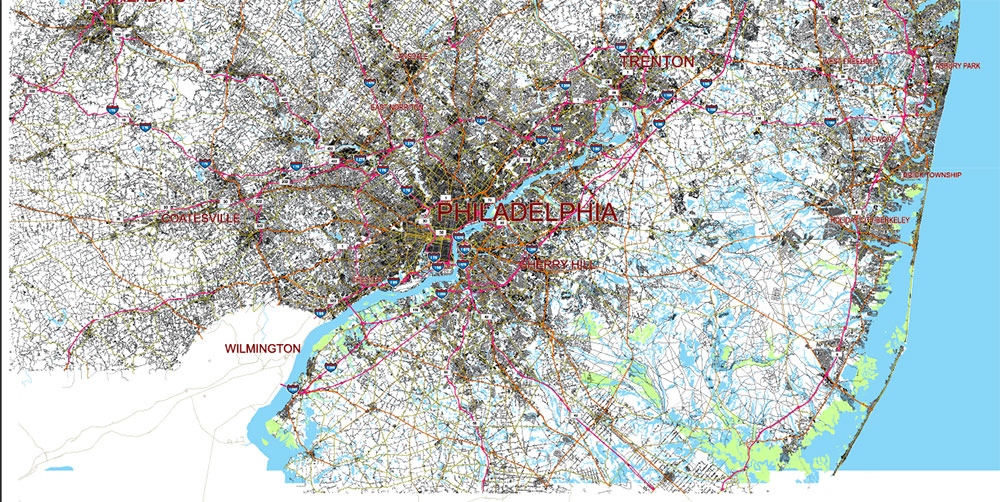
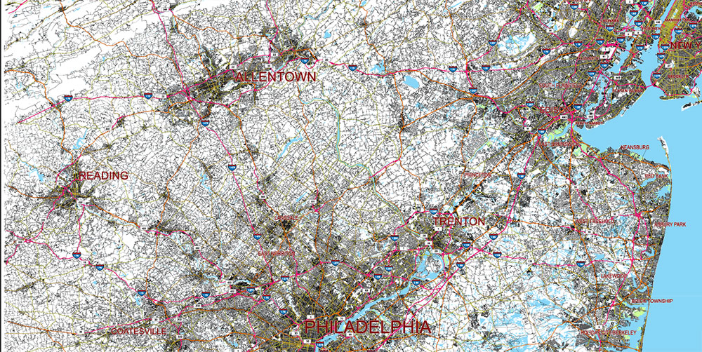
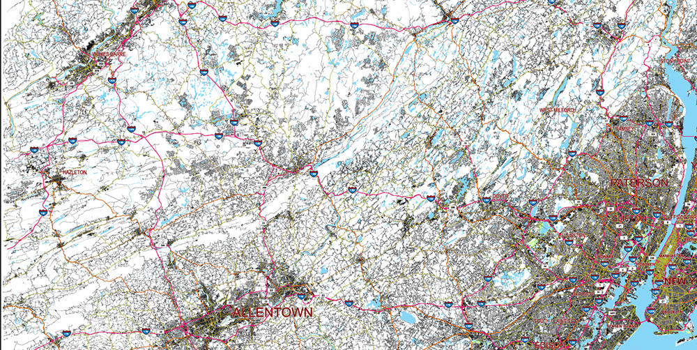
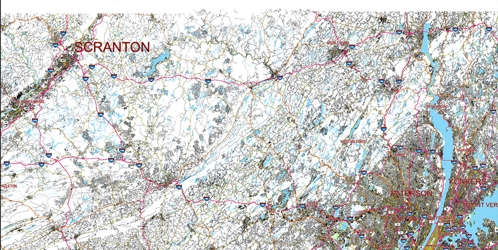
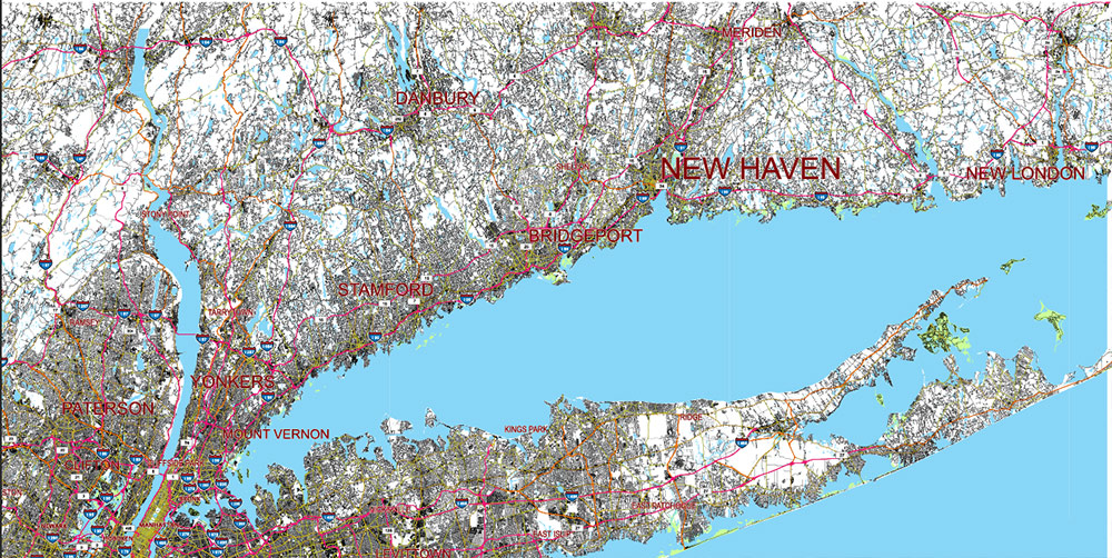
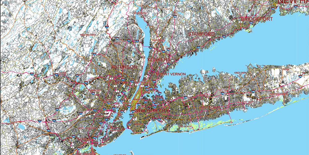
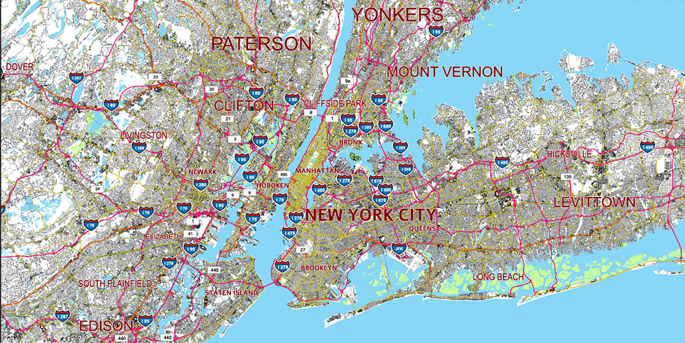
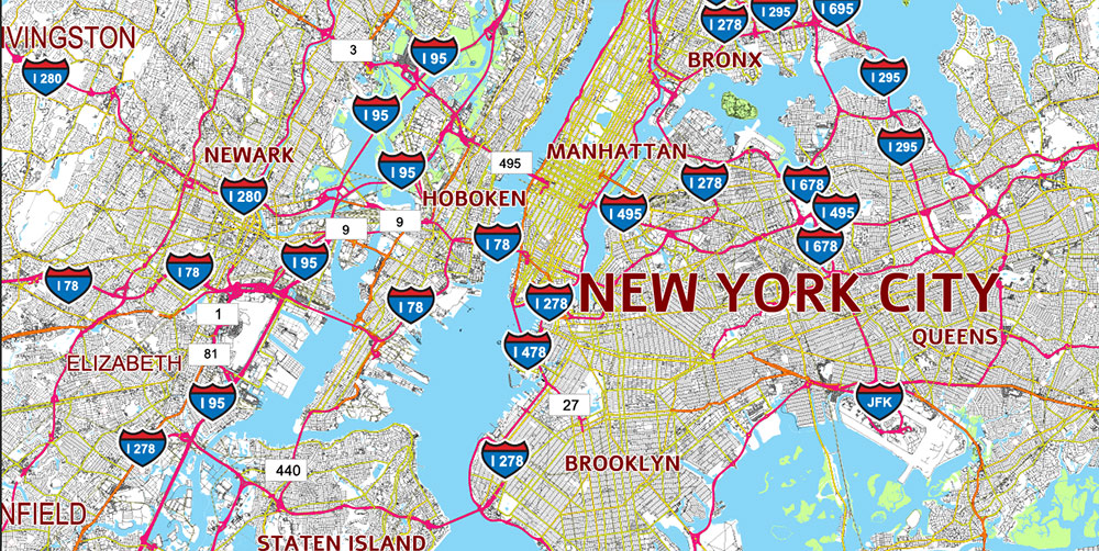
Printable PDF Vector Map of New York City NYC MEGA-REGION (NYC + North NJ + East PA + South NY + South CT) High detailed road map fully editable Layered Adobe PDF scalable, curves format all names, 280 MB ZIP
Large Area: Includes east part of Pennsylvania, South part of New Yorl state, South part of Connecticut, North part of New Jersey. Road shields and numbers.
All street and roads, Water Objects, Railroads, Main cities and towns. Map for design, printing, arts, projects, presentations, for architects, designers, and builders, business, logistics.
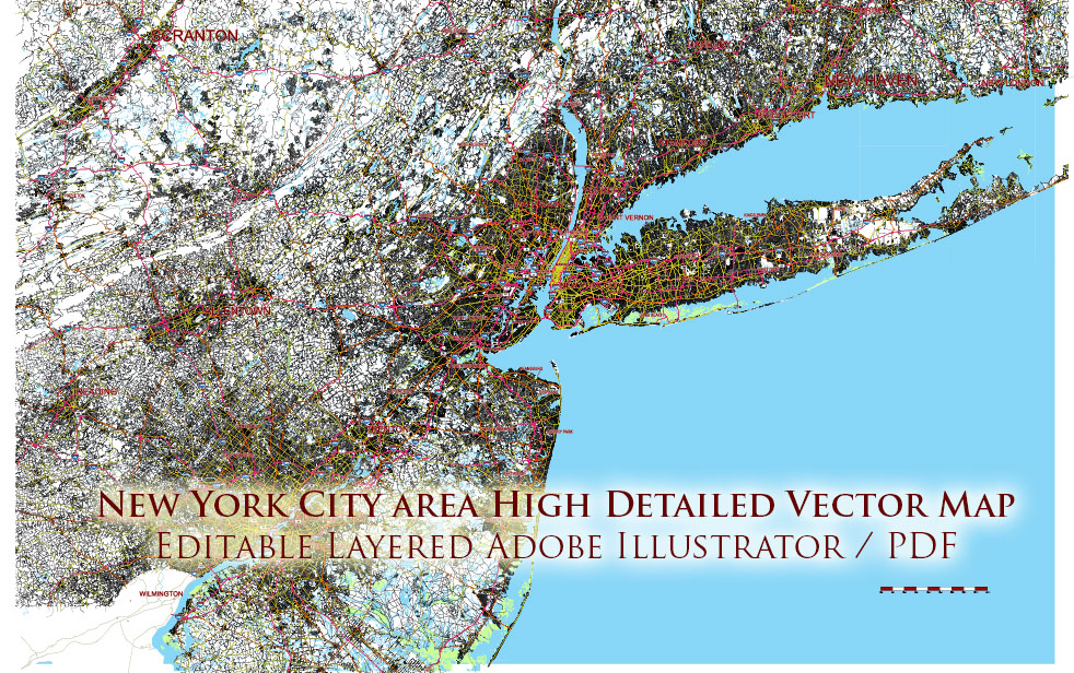
New York City NYC MEGA-REGION (NYC + North NJ + East PA + South NY + South CT) USA PDF Map Vector Exact City Plan High Detailed Street Map editable Adobe PDF in layers
Layers list:
- Scale.
- Names of places (city, town, etc.)
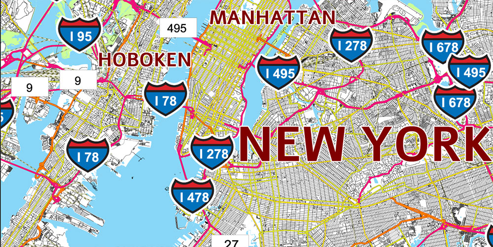
- Numbers of roads (shields)
- Main Streets, roads
- Residential streets
- Railroads
- Airports and Heliports
- Water objects (rivers, lakes, ponds)
- Islands
- Background and Sea
The most exact and detailed map of the city in scale.
For Editing and High-Quality Printing
AO BRIEF — NYC MEGA-REGION (NYC + North NJ + East PA + South NY + South CT)
Overview
-
Area: Core is New York City; operational region expands across North Jersey (Hudson–Bergen–Essex–Union–Passaic–Morris), East Pennsylvania (Lehigh Valley–Bucks–Montgomery–Delaware–Philadelphia fringe), South New York (Lower Hudson Valley–Long Island), and South Connecticut (Fairfield–New Haven corridor).
-
Terrain: Coastal urban plain (NYC/LI/NJ Meadowlands) transitioning to Piedmont + Highlands (NJ/NY/CT) and Appalachian ridge/valley influences west toward PA. Dense built-up zones along coast/river valleys; wooded uplands inland.
-
Key natural lines: Hudson River (primary N–S axis), East River/Long Island Sound (maritime corridor), Raritan Bay–Arthur Kill–Kill Van Kull (port approaches), Delaware River basin (westward logistics corridor), plus chokepoints at major crossings.
Key Roads / Lines of Communication (LOC)
Primary highway spine + ring structure
-
I-95 (Northeast Corridor highway): NJ Turnpike → GW Bridge approaches → Cross Bronx/Throgs Neck/Whitestone approaches (via connectors) → CT Turnpike. High density, chronic congestion; strategic “must-hold” LOC.
-
I-295 / Cross Bronx / Bruckner system: Critical Bronx distribution web tying to Throgs Neck Bridge and Bruckner Interchange.
-
I-278 (NYC/NJ belt segments): Staten Island ↔ Brooklyn/Queens belt; ties port/warehouse areas to bridges and expressways.
River crossings (key choke nodes)
-
Hudson crossings: GW Bridge, Lincoln Tunnel, Holland Tunnel = principal Manhattan–NJ gateways.
-
East River crossings: Brooklyn, Manhattan, Williamsburg, Queensboro bridges; Midtown Tunnel and Brooklyn–Battery Tunnel (Hugh L. Carey).
-
Sound / LI connectors: Throgs Neck and Whitestone bridges = Queens–Bronx link toward Westchester/CT.
-
Outer region: Tappan Zee / Mario Cuomo Bridge (Hudson Valley bypass), Verrazzano-Narrows (Staten Island–Brooklyn).
East–West corridors
-
I-80: North NJ to PA (major freight artery).
-
I-78: Newark/Elizabeth port approaches → west to PA; heavy truck relevance.
-
I-287: NJ/NY bypass arc; key for avoiding Manhattan core; links to I-87 / Hudson Valley.
-
I-95 / NJ Turnpike connectors: Industrial logistics from South/West NJ into the port/metro.
-
I-476 / PA Turnpike system (east PA): Links Philly fringe/Lehigh Valley into broader Northeast freight network.
-
US-1 / US-9 corridor: Parallel coastal/local arterial spine through NJ into metro gateways.
South NY / Long Island LOC
-
LIE (I-495): Primary LI trunk to Queens/NYC; decisive for airport access and eastward distribution.
-
Northern State / Southern State / Meadowbrook / Wantagh: High-capacity parkway web (car-dominant; truck restrictions common).
-
Belt Parkway: Coastal NYC belt; important but congestion-prone.
South CT LOC
-
I-95 (CT Turnpike): Fairfield County linear urban corridor; chronic bottlenecks.
-
Merritt Parkway (CT-15): High-flow passenger bypass; generally not a freight solution (parkway constraints).
-
I-84 (inland CT/NY access): Inland alternate route; links to Hudson Valley and broader New England routes.
Ports / Maritime Access
-
Port of New York and New Jersey (NY/NJ Harbor complex):
-
Core container/ro-ro and breakbulk capacity centered around Newark–Elizabeth and harbor terminals.
-
Arthur Kill / Kill Van Kull channels are strategic maritime approaches connecting terminals to the ocean via the Narrows.
-
Secondary / supporting ports & terminals:
-
Long Island Sound nodes (South CT):
-
Delaware River port system (east PA / Philly fringe):
Rail, Air, and Intermodal (Sustainment)
-
Rail backbone: Northeast Corridor passenger rail runs through the axis; freight intermodal yards concentrate in NJ (near port/industrial zones) and inland junctions.
-
Air hubs: JFK, LaGuardia, Newark (EWR) are tri-hub core; Islip/MacArthur and Westchester are secondary; Philadelphia becomes relevant on the west flank.
-
Intermodal gravity wells: Port-adjacent NJ, Meadowlands, and major highway interchanges (I-95/I-78/I-80/I-287 meshes).
Demography / Human Terrain
-
Population density: Extreme in NYC core and inner-ring NJ/Westchester/Long Island; gradually decreases toward PA and inland uplands.
-
Economic zones: Global finance/media/tech in Manhattan; major industrial/logistics along NJ waterfront and interchanges; mixed high-income residential corridors in Westchester/Fairfield; large suburban commuter belts in LI/NJ/PA.
-
Cultural/linguistic: Highly multilingual, diverse communities; neighborhood-level micro-terrain matters for movement, services, and demand patterns.
Climate / Seasonality
-
Humid subtropical / coastal temperate mix: Hot humid summers; cold winters with periodic snow/ice.
-
Key seasonal risks: Nor’easters, coastal storms, storm surge exposure; freeze–thaw impacts on roads; summer heat stress.
Hazards / Threats
-
Chokepoints + congestion: Bridges/tunnels and key interchanges are single points of failure; routine congestion is the norm.
-
Coastal flooding / surge: Low-lying waterfronts (NJ Meadowlands, NYC coastal edges, LI south shore, parts of CT coast) vulnerable.
-
Critical infrastructure density: Power, transit, communications, and port systems tightly coupled; cascading disruptions possible.
-
Regulatory friction: Truck restrictions on parkways; toll networks; height/weight constraints at some crossings/routes.
Logistics / Sustainment
-
Best freight posture: Favor I-78/I-95/NJ Turnpike + port-side intermodal for harbor-linked movement; I-80/I-287 for bypass and inland distribution; PA Turnpike/I-476 for west-flank resupply.
-
Avoidance rules of thumb:
-
Avoid Manhattan core for through-movement whenever possible.
-
Use bypass arcs (I-287, I-295 segments, selected belt routes) but expect bottlenecks at crossings regardless.
-
Key distribution belts: NJ warehouse zones (Turnpike corridor), Bronx/Queens industrial pockets, Long Island hubs near I-495, Fairfield/Westchester corridor nodes, Lehigh Valley distribution on the PA flank.
Command Takeaways
-
The region runs on crossings: Control/availability of Hudson tunnels/bridges and East River bridges/tunnels dictates tempo.
-
Harbor is the sustainment engine: NY/NJ harbor terminals + NJ highway mesh are the primary logistics heart.
-
Linear corridors dominate: Movement funnels along I-95 coastal axis, Hudson Valley spine, and Long Island trunk; bypass capacity exists but is constraint-heavy.
-
Plan for disruption: Weather + congestion + infrastructure coupling mean redundancy (alternate routes, time windows, modal shifts) is mandatory.
New York City NYC MEGA-REGION (NYC + North NJ + East PA + South NY + South CT) USA PDF Map Vector Exact City Plan High Detailed Street Map editable Adobe PDF in layers
New York City NYC MEGA-REGION (NYC + North NJ + East PA + South NY + South CT) USA PDF Map Vector Exact City Plan High Detailed Street Map editable Adobe PDF in layers
New York City NYC MEGA-REGION (NYC + North NJ + East PA + South NY + South CT) USA PDF Map Vector Exact City Plan High Detailed Street Map editable Adobe PDF in layers
New York City NYC MEGA-REGION (NYC + North NJ + East PA + South NY + South CT) USA PDF Map Vector Exact City Plan High Detailed Street Map editable Adobe PDF in layers
New York City NYC MEGA-REGION (NYC + North NJ + East PA + South NY + South CT) USA PDF Map Vector Exact City Plan High Detailed Street Map editable Adobe PDF in layers
New York City NYC MEGA-REGION (NYC + North NJ + East PA + South NY + South CT) USA PDF Map Vector Exact City Plan High Detailed Street Map editable Adobe PDF in layers
New York City NYC MEGA-REGION (NYC + North NJ + East PA + South NY + South CT) USA PDF Map Vector Exact City Plan High Detailed Street Map editable Adobe PDF in layers
New York City NYC MEGA-REGION (NYC + North NJ + East PA + South NY + South CT) USA PDF Map Vector Exact City Plan High Detailed Street Map editable Adobe PDF in layers
New York City NYC MEGA-REGION (NYC + North NJ + East PA + South NY + South CT) USA PDF Map Vector Exact City Plan High Detailed Street Map editable Adobe PDF in layers

 Author: Kirill Shrayber, Ph.D. FRGS

