Extended Description of the Vector Map
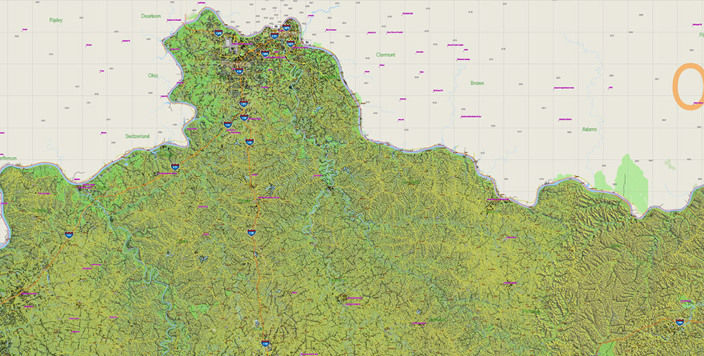
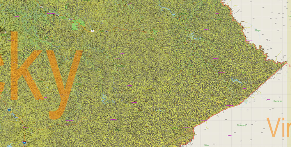
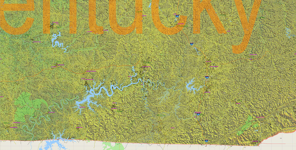
Printable Relief PDF Vector Map of Kentucky Full State US: All Streets and Roads + counties areas + zip-codes areas + Relief Shaded Raster, fully editable Adobe PDF Map in layers, scalable, 529 MB ZIP
Scale: 1:59399
All streets and roads, Names of Principal streets, All Cities and Towns, Counties, All Geonames, airports, and heliports. Map for design, printing, arts, projects, presentations, for architects, designers, and builders, business, logistics.
NOTE! All objects are located on separate layers by type. The preview shows them all together. When you work with this map, just turn off or delete those layers that are not needed for your project.
For Editing and High-Quality Printing, Royalty free
Need AutoCAD DWG / DXF, CDR, or any other format? Please, contact us!
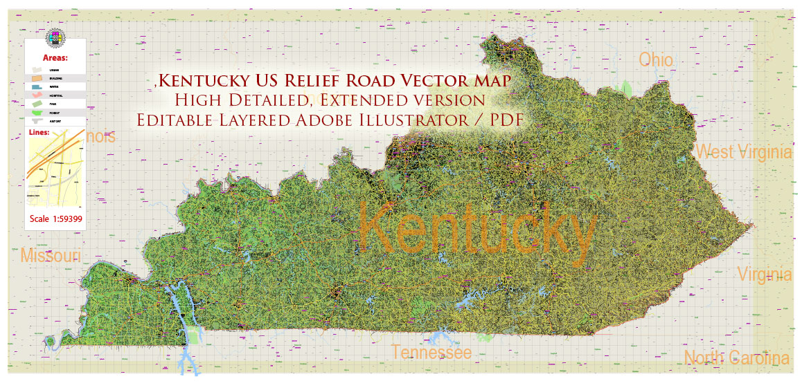
Kentucky Full State US Relief PDF Vector Map: Full Extra High Detailed (all roads, zipcodes, airports) + Admin Areas + Relief Shaded Raster, editable Adobe PDF in layers
Layers list:
- Legend
- Grids
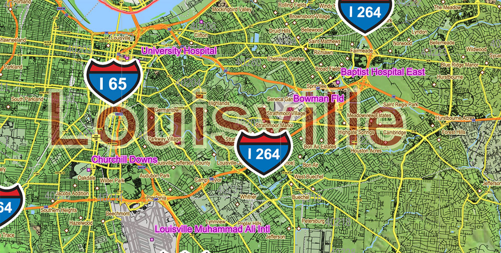
- Labels of roads (numbers) – highways, interstate
- Classic Road Labels (shields)
- All Geonames (cities, towns, villages, hamlets, islands)
- Points of the Geonames (cities, towns, villages, hamlets, islands)
- Names places: Names of all Cities, towns, villages and hamlets
- Names of the Airports and Heliports
- Points of the Airports and Heliports
- Numbers of ZIP codes
- Names of objects (water, park, hospital)
- Names of States
- Names of Counties
- Names of the Main Streets
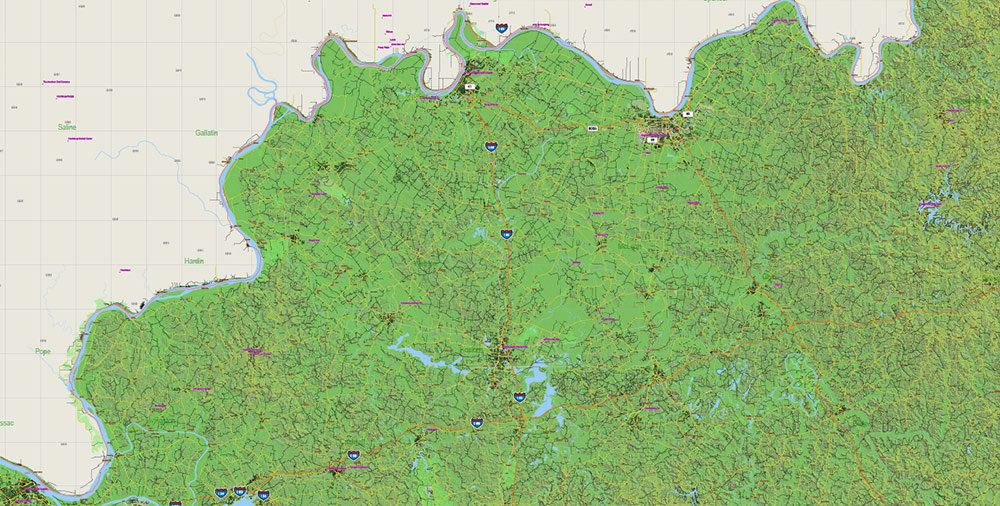
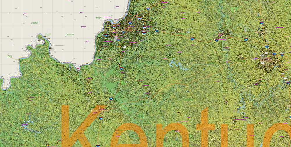
- Major Roads and Streets – Highways
- Minor Roads and residential streets
- Railroads
- State boundaries
- Water objects (rivers, lakes, ponds, swamps, reefs)
- Waterways
- Ground objects (urban areas, parks, hospitals, etc.)
- ZIP-codes areas
- Counties areas (colored, transparence 10%)
- State area
- Raster Shaded Relief
- Background
Kentucky Full State US Relief PDF Vector Map: Full Extra High Detailed (all roads, zipcodes, airports) + Admin Areas + Relief Shaded Raster, editable Adobe PDF in layers
AO BRIEF — KENTUCKY (KY)
Operational Geography Summary for Deployment Planning
1. AO OVERVIEW
Interior U.S. state bridging the Midwest and the Southeast. Terrain transitions from Appalachian highlands in the east to rolling Bluegrass and lowlands in the west. Major river systems define mobility and logistics: Ohio River (north) and Mississippi River (far west) form natural boundaries and supply lines. State divided into distinct operational sub-regions with varied elevation, forest density, and rural population distribution.
2. KEY TERRAIN & GEOGRAPHY
-
Appalachian Mountains (Eastern KY): Rugged terrain, narrow valleys, dense forests. Limited road access; ideal for concealment, poor for mechanized movement.
-
Bluegrass Region (Central KY): Rolling hills, open pasturelands, moderate forest cover. High-mobility zone with major population centers.
-
Pennyroyal Plateau (South-central): Karst landscape, sinkholes, cave networks; mixed farmland and forests.
-
Western Coal Fields: Mixed industrial and agricultural terrain; moderate elevation.
-
Jackson Purchase (Far West): Flat, river-dominated lowlands bordering Tennessee and the Mississippi River.
3. HYDROGRAPHY / WATERWAYS
-
Ohio River: Strategic boundary; heavy commercial traffic, port facilities near Louisville and Owensboro.
-
Mississippi River: Western AO boundary; logistical gateway but sparsely populated.
-
Kentucky River: Cuts through central region; influences road routing and urban development.
-
Cumberland & Tennessee Rivers: Navigable segments; reservoirs create water barriers and recreation zones.
-
Mammoth Cave System: Largest cave system on Earth; major subterranean terrain consideration.
4. CLIMATE & SEASONALITY
Humid subtropical.
-
Summer: Hot, humid; thunderstorm and tornado risk (especially western/central sectors).
-
Winter: Mild to cold; snow mainly in eastern mountains.
-
Spring/Fall: Variable, frequent rainfall; flooding risk along Ohio and inland rivers.
-
Year-round: High humidity and fog in valleys; impacts visibility and aviation.
5. DEMOGRAPHY & HUMAN TERRAIN
Population ~4.5M, dispersed with strong urban-rural divide.
-
Louisville Metro (~1.3M): Economic, transport, and cultural hub.
-
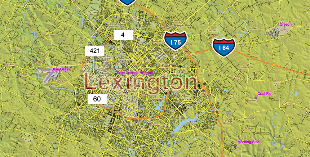
Lexington (~320k): University city; high education level; core of the Bluegrass region.
-
Eastern Appalachia: Low density, economically stressed, culturally cohesive communities.
-
Western KY: Industrial, agricultural, mixed-use terrain.
Culture: Southern-Midwestern hybrid identity; polite, reserved population; strong community ties; stable civil environment with low large-scale unrest risk.
6. KEY CITIES / URBAN AO
-
Louisville:
-
Largest city, UPS Worldport air-cargo hub.
-
Densely urbanized along Ohio River.
-
Key nodes: Downtown grid, airport corridor, riverfront industrial strips.
-
Lexington:
-
Bowling Green:
-
Owensboro:
-
Covington/Newport:
7. LINES OF COMMUNICATION (LOC) / ROAD NETWORK
Kentucky is crossed by high-quality interstate corridors crucial for rapid deployment.
Interstates
-
I-64: East–west spine (Louisville → Lexington → West Virginia).
-
I-65: North–south (Louisville → Bowling Green → Nashville).
-
I-75: North–south (Cincinnati area → Lexington → Tennessee); primary Appalachian axis.
-
I-24: Western KY route linking Illinois → Tennessee → Fort Campbell region.
-
I-71: Louisville → Cincinnati; part of Midwest logistics chain.
Auxiliary Routes
Rail and aviation strong near Louisville; UPS cargo operations form critical national infrastructure.
8. ECONOMICS & INFRASTRUCTURE
-
Mixed economy: logistics, manufacturing, automotive, agriculture, bourbon production.
-
Louisville airport (SDF) is a Tier-1 national logistics node.
-
Numerous power plants along rivers; redundant energy grid.
-
Rural broadband coverage improving but patchy in Appalachia.
9. HAZARDS / THREATS
-
Tornadoes: Central and western Kentucky.
-
Flooding: Ohio River valley and tributaries; spring high-risk.
-
Ice storms: Periodic winter events affecting power lines.
-
Fog: Persistent in valleys; aviation and highway hazard.
-
Landslides: Eastern mountain roads.
10. LOGISTICS & SUSTAINMENT
-
UPS Worldport (Louisville): One of the largest air logistics hubs globally; critical for rapid sustainment.
-
Interstates I-64/I-65/I-75 form reliable high-speed deployment grid.
-
Rural southeast requires advance recon due to narrow, winding mountain roads.
-
Rail freight concentrated around Louisville, central/western corridors.
11. COMMAND TAKEAWAYS
-
Louisville is the decisive strategic node (air logistics, interstate junctions, population center).
-
Central Bluegrass offers best mobility and sustainment options.
-
Appalachian east is restrictive terrain — ideal for concealment, poor for mechanized units.
-
River systems shape movement and pose seasonal flood hazards.
-
Overall AO provides high mobility, strong logistics, and stable human terrain with predictable infrastructure.

Kentucky Full State US Relief PDF Vector Map: Full Extra High Detailed (all roads, zipcodes, airports) + Admin Areas + Relief Shaded Raster, editable Adobe PDF in layers
Kentucky Full State US Relief Vector Map: Full Extra High Detailed (all roads, zipcodes, airports) + Admin Areas + Relief Shaded Raster, editable Adobe Illustrator in layers
Kentucky Full State US Relief PDF Vector Map: Full Extra High Detailed (all roads, zipcodes, airports) + Admin Areas + Relief Shaded Raster, editable Adobe PDF in layers
Kentucky Full State US Relief PDF Vector Map: Full Extra High Detailed (all roads, zipcodes, airports) + Admin Areas + Relief Shaded Raster, editable Adobe PDF in layers
Kentucky Full State US Relief PDF Vector Map: Full Extra High Detailed (all roads, zipcodes, airports) + Admin Areas + Relief Shaded Raster, editable Adobe PDF in layers
Kentucky Full State US Relief PDF Vector Map: Full Extra High Detailed (all roads, zipcodes, airports) + Admin Areas + Relief Shaded Raster, editable Adobe PDF in layers
Kentucky Full State US Relief PDF Vector Map: Full Extra High Detailed (all roads, zipcodes, airports) + Admin Areas + Relief Shaded Raster, editable Adobe PDF in layers
Kentucky Full State US Relief PDF Vector Map: Full Extra High Detailed (all roads, zipcodes, airports) + Admin Areas + Relief Shaded Raster, editable Adobe PDF in layers

Kentucky Full State US Relief PDF Vector Map: Full Extra High Detailed (all roads, zipcodes, airports) + Admin Areas + Relief Shaded Raster, editable Adobe PDF in layers
Kentucky Full State US Relief PDF Vector Map: Full Extra High Detailed (all roads, zipcodes, airports) + Admin Areas + Relief Shaded Raster, editable Adobe PDF in layers

Kentucky Full State US Relief PDF Vector Map: Full Extra High Detailed (all roads, zipcodes, airports) + Admin Areas + Relief Shaded Raster, editable Adobe PDF in layers

 Author: Kirill Shrayber, Ph.D. FRGS
 + Admin Areas editable Adobe Illustrator in layers")
 + Admin Areas + Relief Shaded Raster, editable Adobe Illustrator in layers")
