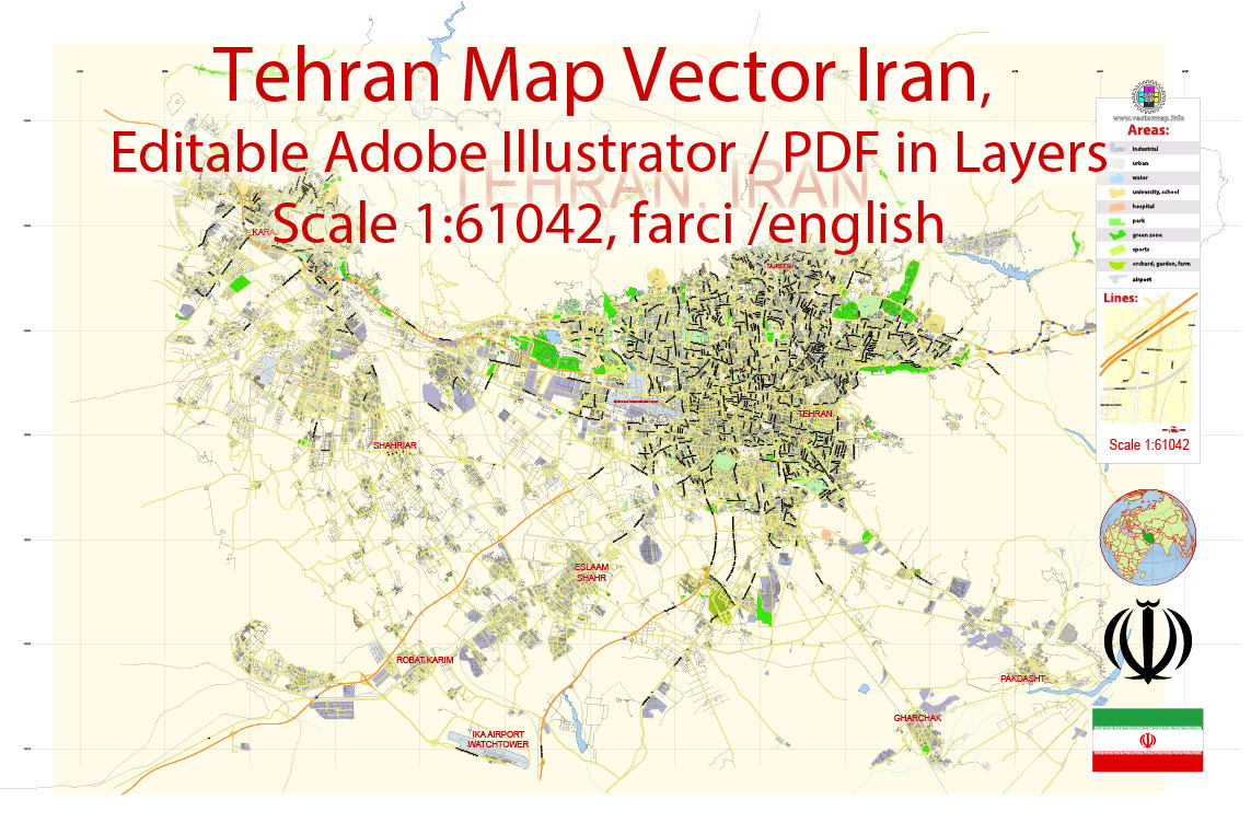
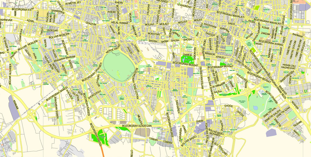
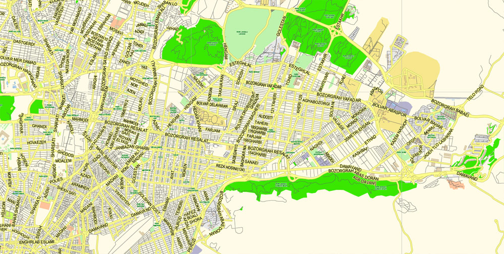
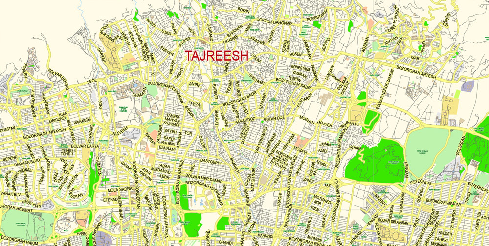
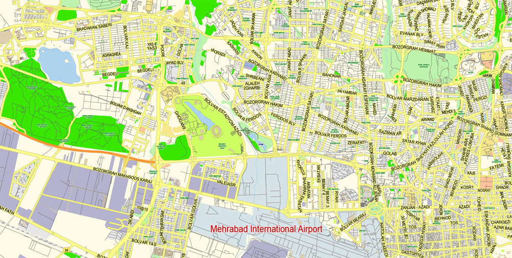
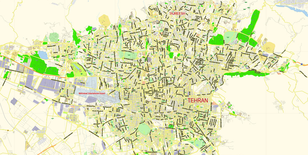
Printable PDF Vector Map of Tehran Iran EN Low detailed City Plan scale 1:61042 full editable AdobeIl PDF Street Map in layers for small print size, scalable, editable text format all names, 36 mb ZIP
English / Farci Principal streets names, Main Objects, Buildings. Map for design, printing, arts, projects, presentations, for architects, designers and builders, business, logistics.
Layers: color_fills, streets_roads, labels_roads, names_objects, names_streets, names_places, grids, legend.
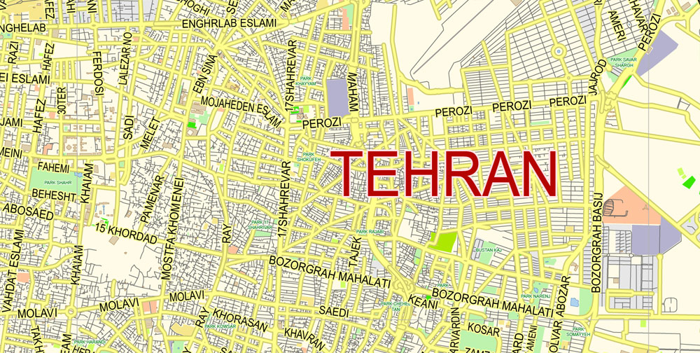
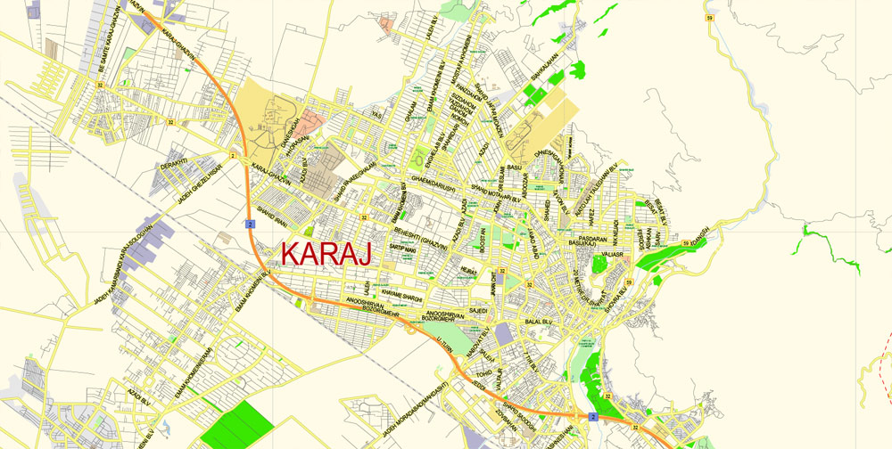
The most exact and detailed map of the city in scale.
For Editing and High Quality Printing small size
DWG, DXF and other formats – on request, same price, please, contact.
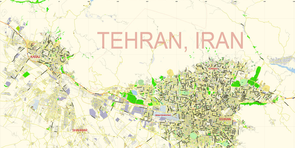
Tehran is the capital of Iran and Tehran Province. With a population of around 8.4 million in the city and 15 million in the larger metropolitan area of Greater Tehran, Tehran is the most populous city in Iran and Western Asia, and has the second-largest metropolitan area in the Middle East.
For your convenience, all objects on Tehran vector city map are divided into layers, and the editing is very easy – colors, lines, etc.
You can easily add any objects needed (e.g. shops, salons, sale points, gas station or attraction) on any layer of Tehran vector map.
It is ranked 29th in the world by the population of its metropolitan area. The undoubted advantage of Tehran city vector maps in printing is an excellent and detailed visualization, when customer can expand a large paper map and instantly define his location, find a landmark, an object or address on map, unlike using the popular electronic formats of Google and Yandex maps for example.
Printable vector maps of Tehran city are much more convenient and efficient than any electronic maps on your smartphone, because ALL DETAILS are displayed in the entire space of Tehran city map.
In the Classical era, part of the territory of present-day Tehran was occupied by Rhages, a prominent Median city. It was subject to destruction through the medieval Arab, Turkic, and Mongol invasions. Its modern-day inheritor remains as an urban area absorbed into the metropolitan area of Greater Tehran.
Tehran was first chosen as the capital of Iran by Agha Mohammad Khan of the Qajar dynasty in 1796, in order to remain within close reach of Iran’s territories in the Caucasus, before being separated from Iran as a result of the Russo-Iranian Wars, and to avoid the vying factions of the previously ruling Iranian dynasties.
For travelers, maps are sold at the airports and gas stations around the world. Often the source is our vector maps.
The capital has been moved several times throughout the history, and Tehran is the 32nd national capital of Iran. Large scale demolition and rebuilding began in the 1920s, and Tehran has been a destination for mass migrations from all over Iran since the 20th century. The Tehran city map in vector format is used for design, urban planning, presentations and media visualizations.
The advertising and presentation map of Tehran city (usually the final designer marks the routes, and puts the client’s objects (shops, saloons, gas stations etc.)
The undoubted advantage is that people will NEVER throw out this advertising product – the map. In fact, as an advertising medium, a city map is the most “long-playing” of the well-known polygraphic advertising media, with the longest lifespan, and the maximum number of interactions with the customer.
Tehran is home to many historical collections, including the royal complexes of Golestan, Sa’dabad, and Niavaran, where the two last dynasties of the former Imperial State of Iran were seated.
It’s very easy to work with vector maps of Tehran city, even for a not very experienced designer who can turn on and off the map layers, add new objects, change the colors of fill and lines according to customer requirements.
Tehran’s most famous landmarks include the Azadi Tower, a memorial built under the reign of Mohammad Reza Shah of the Pahlavi dynasty in 1971 to mark the 2,500th year of the foundation of the Imperial State of Iran, and the Milad Tower, the world’s sixth-tallest self-supporting tower which was completed in 2007.
One of the advantages of Tehran city vector maps of our production is the relevance of cartographic data, we constantly update all our products.
This vector map of Tehran city is used by:
designers, layout designers, printers, advertisers and architects. Our product – vector maps – is designed for further editing and printing in large formats – from @Wall format (a few meters) to A-0 and A-1, A-2, A-3.
The Tabiat Bridge, a newly-built landmark, was completed in 2014. Take a look, who purchases our vector maps of Tehran city in “Our Clients and Friends” page – these are large and small companies, from super-brands like Volvo and Starbucks, to small design studios and printing houses.
You will probably want to change the color scheme used on our Tehran vector city map.
To quickly and effectively play with colors.
Of course, you can do it manually, all objects in our Tehran city vector map are divided according to types and layers, and you can easily change the color gamma of vector objects in groups and layers.
But there is more effective way of working with the whole VECTOR MAP of Tehran city and all layers:
The overview dialog «Edit colors»/«Repaint Graphic Object» (this dialog box name can change depending on the context):
If you have selected a part or a layer of Tehran city vector map and open the dialog box by clicking the icon in the Control panel, on the Samples palette or the Color Catalog, or if you choose Edit > Edit Colors> Repaint Graphic Object, then the «Repaint Graphic Object» dialog box appears, and you get access to «Assign» and «Edit» tabs.
This vector map of Tehran city is used as a basis for design, editing, and further printing.
The majority of the population of Tehran are Persian-speaking people, and roughly 99% of the population understand and speak Persian, but there are large populations of other ethno-linguistic groups who live in Tehran and speak Persian as a second language. If a picture or a map fragment is not selected, and you open the dialog box by clicking the icon in the Control panel, on the Samples palette or in the Color Catalog, the «Edit Colors» dialog box appears and you can only access the «Edit» tab.
Regardless of the name at the top of the dialog box, the right-hand side always displays the color group of the current document, as well as two default color groups: Print Color and Grayscale. These color groups can be selected and used any time.
Create and edit color groups of Tehran city vector map, and also assign colors using the «Edit Colors»/ а «Repaint Graphic Object» dialog box.
A. Creating and editing of a color group on the «Edit» tab
B. Assigning colors on the «Assign» tab
C. Select a group of colors from the «Color groups» list
The option «Repaint a graphic object» in the lower part of the dialog box allows you to preview the colors on a selected layer of Vector map, or a group of elements, and specify whether its colors will be redefined when the dialog box is closed.
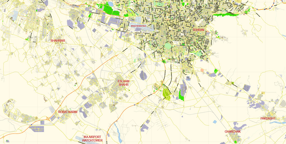
Tehran has an international airport (Imam Khomeini Airport) , a domestic airport (Mehrabad Airport), a central railway station, the rapid transit system of Tehran Metro, a bus rapid transit system, trolleybuses, and a large network of highways.
There have been plans to relocate Iran’s capital from Tehran to another area, due mainly to air pollution and the city’s exposure to earthquakes.
This is the most detailed, exact map of Tehran city for high-quality printing and polygraphy. You can always clarify the map development date by contacting us.
To date, no definitive plans have been approved. A 2016 survey of 230 cities by consultant Mercer ranked Tehran 203rd for quality of life. According to the Global Destinations Cities Index in 2016, Tehran is among the top ten fastest growing destinations.
October 6 is marked as Tehran Day based on a 2016 decision by members of the City Council, celebrating the day when the city was officially chosen as the capital of Iran by the Qajar dynasty back in 1907.
The specified button is available if the selected vector map or its fragment contains two or more colors.
Note. This color editing method is convenient for global color adjustment in a vector map, if global colors were not used when creating a City Map of Tehran.
Geography
Location and subdivisions
The metropolis of Tehran is divided into 22 municipal districts, each with its own administrative center. 20 of the 22 municipal districts are located in Tehran County’s Central District, while the districts 1 and 20 are respectively located in the counties of Shemiranat and Ray. Although administratively separate, the cities of Ray and Shemiran are often considered part of Greater Tehran.
Useful tips on working with vector maps of cities and countries in Adobe Illustrator.
«V» – launches the Selection tool (cursor, black arrow), which makes active any vector line.
«А» – launches the Direct Selection tool (white cursor), allows you to select curve elements and drag them to the desired place.
«R» – activates the Rotate tool, which helps you rotating selected objects around the center point by 360 degrees.
«E» – gives you the opportunity to use the Eraser tool and erase unnecessary parts.
«X» – switches between Fill and Stroke in the Tools section. Try to get used to this hot key and
you will quickly understand that you can’t live and work without it.
Guides are not limited to vertical and horizontal in Adobe Illustrator. You can also create a diagonal guide for example. Moreover, you can turn any contours into guides. Select the outline and go to View > Guides > Make Guides (Create Guides), or simply press Cmd/Ctrl + 5. You can also turn the guides back into an editable object. Go to menu, View > Guides > Unlock Guides (Release Guides), select the guide you want to edit and select View > Guides > Release Guides (Reset Guides), or just press Cmd/Ctrl + Option / Alt + 5).
The main areas of the dialog box are:
«Edit»
The «Edit» tab is designed to create a new or edit the existing color groups.
The harmony rules Menu and the Color Wheel are used to conduct experiments with color harmonies. The color wheel shows how colors are related in color harmony, and the color bars allow you to view and manipulate an individual color values. In addition, you can adjust the brightness, add and remove colors, save color groups and view colors on the selected Vector Map of Tehran city or a separated layers.
Assign
The «Assign» tab is used to view and control on how the original colors are replaced with colors from the color group like your corporate colors in the Vector Map of Tehran city.
The assign color ability is provided only if the entire map, layer or fragment is selected in the document. You can specify which of new colors replace the current colors, whether the spot colors should be preserved and how colors are replaced (for example, you can replace colors completely or changing the color tone while maintaining the brightness). The «Assign» tab allows you to redefine colors in the Vector Map of Tehran city, or in separate layers and fragments using the current color group or reducing the number of colors in the current Vector Map.
Color groups
Is a list of all saved color groups for current document (the same groups appear in the «Samples» palette). You can edit and delete the existing color groups, as well as creating a new ones using the list of “Color Groups” in the dialog box. All changes appear in the «Samples» palette.
The highlighted color group shows, which color group is currently edited. Any color group can be selected and edited, or used to redefine the colors in the selected vector map of Tehran city, its fragments or elements.
Saving a color group adds this group to the specified list.
Opening the «Edit Colors»/«Repaint Graphic Object» dialog box.
Open the «Edit Colors»/«Repaint Graphic Object» dialog box using one of the following methods:
«Edit»> «Edit Colors»> «Repaint Graphic object» or «Repaint With Style».
Use these commands if you need to edit the colors in the selected vector map of Tehran city.
«Repaint Graphic object» button on the «Control» panel.
Use this button if you need to adjust colors of Tehran city vector map using the а «Repaint graphic object» dialog box.
The «Edit colors» button or «Edit or apply colors» on the «Color Catalog» palette
Click this button if you need to edit colors on the «Color Catalog» palette or edit and then apply them to the selected Vector Map of Tehran city or its fragment.
The «Edit color group» button or «Edit or apply color group» on the «Samples» palette.
Click this button if you need to edit the colors in the specific color group or edit and apply them to the selected Vector Map of Tehran city or a group of its elements, for example, the whole layer “Streets and lines”. You can also double-click the color group in the Samples panel to open the dialog box.
If the map file is too large and your computer freezes or even can’t open it quickly:
1. Try to reduce the color resolution of the video card (display) to 256 colors while working with a large map.
2. Using Windows Task Manager, select all the application you don’t need, while working with map, just turn them off.
3. Launch Adobe Illustrator. (DO NOT OPEN the vector map file)
4. Start the Windows Task Manager using administrator rights > Find the “Illustrator” process > set the «real time» priority,
5. Open the file. When you see the LEGACY FONT popup window – click “OK” (do not update). You can restore the TEXT later.
6. Can also be useful: When file is opened – Edit > Settings > Basic Settings > disable smoothing. /// It looks scary, but works quickly)))
We recommend saving the file in Adobe Illustrator 10 version. It’s much more stable when working with VERY BIG size files.
Tehran
Capital of Iran
Tehran is the capital of Iran, in the north of the country. Its central Golestan Palace complex, with its ornate rooms and marble throne, was the seat of power of the Qajar dynasty. The National Jewelry Museum holds many of the Qajar monarchs’ jewels, while the National Museum of Iran has artifacts dating back to Paleolithic times. The Milad Tower offers panoramic views over the city.
Area
• Urban 574 km2 (222 sq mi)
• Metro 1,748 km2 (675 sq mi)
Elevation 900 to 1,830 m (2,952 to 6,003 ft)
Population
• Density 11,800/km2 (31,000/sq mi)
• Urban 8,693,706
• Population Rank in Iran 1st
Tehran is the capital of Iran and Tehran Province. With a population of around 8.4 million in the city and 15 million in the larger metropolitan area of Greater Tehran, Tehran is the most populous city in Iran and Western Asia, and has the second-largest metropolitan area in the Middle East. It is ranked 29th in the world by the population of its metropolitan area.
In the Classical era, part of the territory of present-day Tehran was occupied by Rhages, a prominent Median city. It was subject to destruction through the medieval Arab, Turkic, and Mongol invasions. Its modern-day inheritor remains as an urban area absorbed into the metropolitan area of Greater Tehran.
Tehran was first chosen as the capital of Iran by Agha Mohammad Khan of the Qajar dynasty in 1796, in order to remain within close reach of Iran’s territories in the Caucasus, before being separated from Iran as a result of the Russo-Iranian Wars, and to avoid the vying factions of the previously ruling Iranian dynasties. The capital has been moved several times throughout the history, and Tehran is the 32nd national capital of Iran. Large scale demolition and rebuilding began in the 1920s, and Tehran has been a destination for mass migrations from all over Iran since the 20th century.
Tehran is home to many historical collections, including the royal complexes of Golestan, Sa’dabad, and Niavaran, where the two last dynasties of the former Imperial State of Iran were seated. Tehran’s most famous landmarks include the Azadi Tower, a memorial built under the reign of Mohammad Reza Shah of the Pahlavi dynasty in 1971 to mark the 2,500th year of the foundation of the Imperial State of Iran, and the Milad Tower, the world’s sixth-tallest self-supporting tower which was completed in 2007. The Tabiat Bridge, a newly-built landmark, was completed in 2014.
The majority of the population of Tehran are Persian-speaking people, and roughly 99% of the population understand and speak Persian, but there are large populations of other ethno-linguistic groups who live in Tehran and speak Persian as a second language.
Tehran has an international airport (Imam Khomeini Airport) , a domestic airport (Mehrabad Airport), a central railway station, the rapid transit system of Tehran Metro, a bus rapid transit system, trolleybuses, and a large network of highways.
There have been plans to relocate Iran’s capital from Tehran to another area, due mainly to air pollution and the city’s exposure to earthquakes. To date, no definitive plans have been approved. A 2016 survey of 230 cities by consultant Mercer ranked Tehran 203rd for quality of life.[13] According to the Global Destinations Cities Index in 2016, Tehran is among the top ten fastest growing destinations.
Free vector map World, Adobe Illustrator, download now maps vector clipart
Map for design, projects, presentation free to use as you like.
See also: TERMS & CONDITIONS: SOFTWARE LICENSE AGREEMENT FOR DIGITAL CARTOGRAPHIC DATA.

 Author: Kirill Shrayber, Ph.D. FRGS