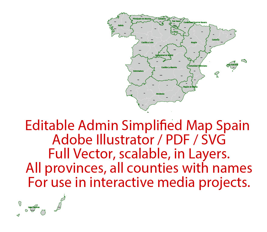
Administrative Vector Map Spain Adobe Illustrator Editable PDF SVG layers simplified Provinces Counties for use in the interactive media projects special edition
Layers: Counties_with_names, Borders_provinces, Names_provinces.
Text format all names
Ready for use in interactive media projects such as http://jvectormap.com/ or jQuery Mapael https://www.vincentbroute.fr/mapael/ https://github.com/neveldo/jQuery-Mapael
Spain.
This vector map of Spain is used as a basis for design, editing, and further printing.
This is the most detailed, exact map of Spain for high-quality printing and polygraphy. You can always clarify the map development date by contacting us.
For your convenience, all objects on Spain vector map are divided into layers. And the editing is very easy – colors, lines, etc.
You can easily add any objects needed (e.g. shops, salons, sale points, gas station or attraction) on any layer of Spain vector map.
Spain is a country mostly located on the Iberian Peninsula in Europe. Its territory also includes two archipelagoes: the Canary Islands off the coast of Africa, and the Balearic Islands in the Mediterranean Sea. The African enclaves of Ceuta and Melilla make Spain the only European country to have a physical border with an African country (Morocco). Several small islands in the Alboran Sea are also part of Spanish territory. The country’s mainland is bordered to the south and east by the Mediterranean Sea except for a small land boundary with Gibraltar; to the north and northeast by France, Andorra, and the Bay of Biscay; and to the west and northwest by Portugal and the Atlantic Ocean.
One of the advantages of Spain vector maps of our production is the relevance of cartographic data, we constantly update all our products.
This vector map of Spain is used by:
designers, layout designers, printers, advertisers and architects. Our product – vector maps – is designed for further editing and printing in large formats – from @Wall format (a few meters) to A-0 and A-1, A-2, A-3.
The Spain map in vector format is used for design, urban planning, presentations and media visualizations.
The advertising and presentation map of Spain (usually the final designer marks the routes, and puts the client’s objects (shops, saloons, gas stations etc.)
The undoubted advantage is that people will NEVER throw out this advertising product – the map. In fact, as an advertising medium, a map is the most “long-playing” of the well-known polygraphic advertising media, with the longest lifespan, and the maximum number of interactions with the customer.
For travelers, maps are sold at the airports and gas stations around the world. Often the source is our vector maps.
Take a look, who purchases our vector maps of Spain in “Our Clients and Friends” page – these are large and small companies, from super-brands like Volvo and Starbucks, to small design studios and printing houses.
It’s very easy to work with vector maps of Spain city, even for a not very experienced designer who can turn on and off the map layers, add new objects, change the colors of fill and lines according to customer requirements.
The undoubted advantage of Spain vector maps in printing is an excellent and detailed visualization, when customer can expand a large paper map and instantly define his location, find a landmark, an object or address on map, unlike using the popular electronic formats of Google and Yandex maps for example.
Printable vector maps of Spain are much more convenient and efficient than any electronic maps on your smartphone, because ALL DETAILS are displayed in the entire space of Spain map.
Useful tips on working with vector maps of cities and countries in Adobe Illustrator.
«V» – launches the Selection tool (cursor, black arrow), which makes active any vector line.
«А» – launches the Direct Selection tool (white cursor), allows you to select curve elements and drag them to the desired place.
«R» – activates the Rotate tool, which helps you rotating selected objects around the center point by 360 degrees.
«E» – gives you the opportunity to use the Eraser tool and erase unnecessary parts.
«X» – switches between Fill and Stroke in the Tools section. Try to get used to this hot key and
you will quickly understand that you can’t live and work without it.
Guides are not limited to vertical and horizontal in Adobe Illustrator. You can also create a diagonal guide for example. Moreover, you can turn any contours into guides. Select the outline and go to View > Guides > Make Guides (Create Guides), or simply press Cmd/Ctrl + 5. You can also turn the guides back into an editable object. Go to menu, View > Guides > Unlock Guides (Release Guides), select the guide you want to edit and select View > Guides > Release Guides (Reset Guides), or just press Cmd/Ctrl + Option / Alt + 5).
You will probably want to change the color scheme used on our Spain vector map.
To quickly and effectively play with colors.
Of course, you can do it manually, all objects in our Spain vector map are divided according to types and layers, and you can easily change the color gamma of vector objects in groups and layers.
But there is more effective way of working with the whole VECTOR MAP of Spain and all layers:
The overview dialog «Edit colors»/«Repaint Graphic Object» (this dialog box name can change depending on the context):
If you have selected a part or a layer of Spain vector map and open the dialog box by clicking the icon in the Control panel, on the Samples palette or the Color Catalog, or if you choose Edit > Edit Colors> Repaint Graphic Object, then the «Repaint Graphic Object» dialog box appears, and you get access to «Assign» and «Edit» tabs.
If a picture or a map fragment is not selected, and you open the dialog box by clicking the icon in the Control panel, on the Samples palette or in the Color Catalog, the «Edit Colors» dialog box appears and you can only access the «Edit» tab.
Regardless of the name at the top of the dialog box, the right-hand side always displays the color group of the current document, as well as two default color groups: Print Color and Grayscale. These color groups can be selected and used any time.
Create and edit color groups of Spain vector map, and also assign colors using the «Edit Colors»/ а «Repaint Graphic Object» dialog box.
A. Creating and editing of a color group on the «Edit» tab
B. Assigning colors on the «Assign» tab
C. Select a group of colors from the «Color groups» list
The option «Repaint a graphic object» in the lower part of the dialog box allows you to preview the colors on a selected layer of Vector map, or a group of elements, and specify whether its colors will be redefined when the dialog box is closed.
The main areas of the dialog box are:
«Edit»
The «Edit» tab is designed to create a new or edit the existing color groups.
The harmony rules Menu and the Color Wheel are used to conduct experiments with color harmonies. The color wheel shows how colors are related in color harmony, and the color bars allow you to view and manipulate an individual color values. In addition, you can adjust the brightness, add and remove colors, save color groups and view colors on the selected Vector Map of Spain or a separated layers.
«Assign»
The «Assign» tab is used to view and control on how the original colors are replaced with colors from the color group like your corporate colors in the Vector Map of Spain city.
The assign color ability is provided only if the entire map, layer or fragment is selected in the document. You can specify which of new colors replace the current colors, whether the spot colors should be preserved and how colors are replaced (for example, you can replace colors completely or changing the color tone while maintaining the brightness). The «Assign» tab allows you to redefine colors in the Vector Map of Spain city, or in separate layers and fragments using the current color group or reducing the number of colors in the current Vector Map.
Color groups
Is a list of all saved color groups for current document (the same groups appear in the «Samples» palette). You can edit and delete the existing color groups, as well as creating a new ones using the list of “Color Groups” in the dialog box. All changes appear in the «Samples» palette.
The highlighted color group shows, which color group is currently edited.
Any color group can be selected and edited, or used to redefine the colors in the selected vector map of Spain city, its fragments or elements.
Saving a color group adds this group to the specified list.
Opening the «Edit Colors»/«Repaint Graphic Object» dialog box.
Open the «Edit Colors»/«Repaint Graphic Object» dialog box using one of the following methods:
«Edit»> «Edit Colors»> «Repaint Graphic object» or «Repaint With Style».
Use these commands if you need to edit the colors in the selected vector map of Spain city.
«Repaint Graphic object» button on the «Control» panel.
Use this button if you need to adjust colors of Spain vector map using the а «Repaint graphic object» dialog box.
The specified button is available if the selected vector map or its fragment contains two or more colors.
Note. This color editing method is convenient for global color adjustment in a vector map, if global colors were not used when creating a Map of Spain.
The «Edit colors» button or «Edit or apply colors» on the «Color Catalog» palette
Click this button if you need to edit colors on the «Color Catalog» palette or edit and then apply them to the selected Vector Map of Spain or its fragment.
The «Edit color group» button or «Edit or apply color group» on the «Samples» palette.
Click this button if you need to edit the colors in the specific color group or edit and apply them to the selected Vector Map of Spain or a group of its elements, for example, the whole layer “Streets and lines”. You can also double-click the color group in the Samples panel to open the dialog box.
If the map file is too large and your computer freezes or even can’t open it quickly:
1. Try to reduce the color resolution of the video card (display) to 256 colors while working with a large map.
2. Using Windows Task Manager, select all the application you don’t need, while working with map, just turn them off.
3. Launch Adobe Illustrator. (DO NOT OPEN the vector map file)
4. Start the Windows Task Manager using administrator rights > Find the “Illustrator” process > set the «real time» priority,
5. Open the file. When you see the LEGACY FONT popup window – click “OK” (do not update). You can restore the TEXT later.
6. Can also be useful: When file is opened – Edit > Settings > Basic Settings > disable smoothing. /// It looks scary, but works quickly)))
We recommend saving the file in Adobe Illustrator 10 version. It’s much more stable when working with VERY BIG size files.
With an area of 505,990 km2 (195,360 sq mi), Spain is the largest country in Southern Europe, the second largest country in Western Europe and the European Union, and the fourth largest country in the European continent. By population, Spain is the sixth largest in Europe and the fifth in the European Union. Spain’s capital and largest city is Madrid; other major urban areas include Barcelona, Valencia, Seville, Málaga and Bilbao.
Modern humans first arrived in the Iberian Peninsula around 35,000 years ago. Iberian cultures along with ancient Phoenician, Greek, Celtic and Carthaginian settlements developed on the peninsula until it came under Roman rule around 200 BCE, after which the region was named Hispania, based on the earlier Phoenician name Sp(a)n or Spania. At the end of the Western Roman Empire the Germanic tribal confederations migrated from Central Europe, invaded the Iberian peninsula and established relatively independent realms in its western provinces, including the Suebi, Alans and Vandals. Eventually, the Visigoths would forcibly integrate all remaining independent territories in the peninsula, including Byzantine provinces, into the Kingdom of Toledo, which more or less unified politically, ecclesiastically and legally all the former Roman provinces or successor kingdoms of what was then documented as Hispania.
In the early eighth century the Visigothic Kingdom fell to the Moors, who arrived to rule most of the peninsula in the year 726, leaving only a handful of small Christian realms in the north, lasting up to seven centuries in the Kingdom of Granada. This led to many wars during a long reconquering period across the Iberian Peninsula, which led to the creation of Kingdom of Leon, Kingdom of Castille, Kingdom of Aragon and Kingdom of Navarre as the main Christian kingdoms to face the invasion. Following the Moorish conquest, Europeans began a gradual process of retaking the region known as the Reconquista, which by the late 15th century culminated in the emergence of Spain as a unified country under the Catholic Monarchs.
In the early modern period, Spain became the world’s first global empire and the most powerful country in the world, leaving a large cultural and linguistic legacy that includes +570 million Hispanophones, making Spanish the world’s second-most spoken native language, after Mandarin Chinese. During the Golden Age there were also many advancements in the arts, with world-famous painters such as Diego Velázquez. The most famous Spanish literary work, Don Quixote, was also published during the Golden Age. Spain hosts the world’s third-largest number of UNESCO World Heritage Sites.
Spain is a secular parliamentary democracy and a parliamentary monarchy, with King Felipe VI as head of state. It is a major developed country and a high income country, with the world’s fourteenth largest economy by nominal GDP and sixteenth largest by purchasing power parity. It is a member of the United Nations (UN), the European Union (EU), the Eurozone, the Council of Europe (CoE), the Organization of Ibero-American States (OEI), the Union for the Mediterranean, the North Atlantic Treaty Organization (NATO), the Organisation for Economic Co-operation and Development (OECD), Organization for Security and Co-operation in Europe (OSCE), the Schengen Area, the World Trade Organization (WTO) and many other international organisations. While not an official member, Spain has a “Permanent Invitation” to the G20 summits, participating in every summit, which makes Spain a de facto member of the group.
Geography
At 505,992 km2 (195,365 sq mi), Spain is the world’s fifty-second largest country and Europe’s fourth largest country. It is some 47,000 km2 (18,000 sq mi) smaller than France and 81,000 km2 (31,000 sq mi) larger than the US state of California. Mount Teide (Tenerife) is the highest mountain peak in Spain and is the third largest volcano in the world from its base. Spain is a transcontinental country, having territory in both Europe and Africa.
Spain lies between latitudes 26° and 44° N, and longitudes 19° W and 5° E.
On the west, Spain is bordered by Portugal; on the south, it is bordered by Gibraltar (a British overseas territory) and Morocco, through its exclaves in North Africa (Ceuta and Melilla, and the peninsula of Vélez de la Gomera). On the northeast, along the Pyrenees mountain range, it is bordered by France and the Principality of Andorra. Along the Pyrenees in Girona, a small exclave town called Llívia is surrounded by France.
Extending to 1,214 km (754 mi), the Portugal–Spain border is the longest uninterrupted border within the European Union.
Islands
Spain also includes the Balearic Islands in the Mediterranean Sea, the Canary Islands in the Atlantic Ocean and a number of uninhabited islands on the Mediterranean side of the Strait of Gibraltar, known as plazas de soberanía (“places of sovereignty”, or territories under Spanish sovereignty), such as the Chafarinas Islands and Alhucemas. The peninsula of Vélez de la Gomera is also regarded as a plaza de soberanía. The isle of Alborán, located in the Mediterranean between Spain and North Africa, is also administered by Spain, specifically by the municipality of Almería, Andalusia. The little Pheasant Island in the River Bidasoa is a Spanish-French condominium.
Geography of Spain
Spain is a country located in southwestern Europe occupying most (about 85 percent) of the Iberian Peninsula and includes a small exclave inside France called Llívia as well as the Balearic Islands in the Mediterranean, the Canary Islands in the Atlantic Ocean 108 km (67 mi) off northwest Africa, and five places of sovereignty (plazas de soberanía) on and off the coast of North Africa: Ceuta, Melilla, Islas Chafarinas, Peñón de Alhucemas, and Peñón de Vélez de la Gomera.
The Spanish mainland is bordered to the south and east almost entirely by the Mediterranean Sea (except for a small land boundary with Gibraltar); to the north by France, Andorra, and the Bay of Biscay; and to the west by the Atlantic Ocean and Portugal. With an area of 504,030 km2, Spain is the largest country in Southern Europe, the second largest country in Western Europe (behind France) and the fourth largest country in the European continent (behind Russia, Ukraine and France). It has an average altitude of 650 m.
Its total area is 504,782 km2 (194,897 sq mi) of which 499,542 km2 (192,874 sq mi) is land and 5,240 km2 (2,023 sq mi) is water. Spain lies between latitudes 36° and 44° N, and longitudes 19° W and 5° E. Its Atlantic coast is 710 km (441 mi) long. The Pyrenees mountain range, extends 435 km (270 mi) from the Mediterranean to the Bay of Biscay. In the extreme south of Spain lie the Straits of Gibraltar, which separate the Iberian peninsula and the rest of Europe from Ceuta and Morocco in North Africa; at its narrowest extent, mainland Spain and Morocco are separated by only 13 km (8.1 mi).
Most of Spain’s boundaries are water: the Mediterranean Sea on the south to the French border and the Atlantic Ocean on the northwest and southwest (in the south as the Golfo de Cádiz and in the north as the Bay of Biscay). Spain also shares land boundaries with France and Andorra along the Pyrenees in the northeast, with Portugal on the west, and with the small British Overseas Territory of Gibraltar near the southernmost tip. The affiliation of Gibraltar has continued to be a contentious issue between Spain and Britain. The sovereignty of the plazas de soberanía on the Mediterranean coast of Morocco is disputed by Morocco.
Spain also has a small exclave inside France called Llívia.
The majority of Spain’s peninsular region consists of the Meseta Central, a highland plateau rimmed and dissected by mountain ranges. Other landforms include narrow coastal plains and some lowland river valleys, the most prominent of which is the Andalusian Plain in the southwest. The country can be divided into ten natural regions or subregions: the dominant Meseta Central, the Cantabrian Mountains (Cordillera Cantabrica) and the northwest region, the Ibérico region, the Pyrenees, the Penibético region in the southeast, the Andalusian Plain, the Ebro Basin, the coastal plains, the Balearic Islands, and the Canary Islands. These are commonly grouped into four types: the Meseta Central and associated mountains, other mountainous regions, lowland regions, and islands.
Spain
Country in Europe
Spain, a country on Europe’s Iberian Peninsula, includes 17 autonomous regions with diverse geography and cultures. Capital city Madrid is home to the Royal Palace and Prado museum, housing works by European masters. Segovia has a medieval castle (the Alcázar) and an intact Roman aqueduct. Catalonia’s capital, Barcelona, is defined by Antoni Gaudí’s whimsical modernist landmarks like the Sagrada Família church.
Gross domestic product: 1.232 trillion USD (2016) Trending, World Bank
Capital: Madrid
Dialing code: +34

 Author: Kirill Shrayber, Ph.D. FRGS


