Santa Fe (New Mexico)
Santa Fe is a city in the southern United States, the administrative center of the state of New Mexico, and the administrative center and largest city of Santa Fe County. The population is 67,947.
1.1. History as part of New Spain and Mexico
On the site of the present Santa Fe, there were originally several pueblo villages that settled here since the XI century AD. One of the earliest known settlements was located on the site of today’s business center of the city and was called Ogopogo. Don Juan de Onate led the first attempt to colonize the region in 1598, creating the province of Santa Fe de Nuevo Mexico as part of New Spain. The provincial capital was the small town of San Juan de Los Caballeros, north of present-day Santa Fe, near the present-day Oke Ovinge Reservation. The second Spanish governor, Don Pedro de Peralta, founded in 1610 a new city at the foot of the Sangre de Cristo Mountains, which he named La Villa Real de la Santa Fe de San Francisco de Asis, the Royal City of the Holy Faith of Saint Francis of Assisi. In 1610, he made it the provincial capital, which it has remained ever since, making it the oldest capital in what is now the United States. Santa Fe is the second oldest American city founded by European colonists in existence, second only to St. Augustine in Florida in 1565. It should be noted that a number of historians do not recognize this status for Santa Fe, since in 1680-1692 it was abandoned due to Indian raids. Several settlements, such as First Pensacola and Fort Caroline, were founded before St. Augustine but failed. Until the Mexican War of Independence, Santa Fe remained a quiet, uneventful provincial town, with the exception of the period 1680-1692, when the rebel pueblos massacred many Spanish settlers, including women and children, forcing the few survivors to flee south. The territory was returned to Spanish control by Diego de Vargas in 1692. In 1824, the city’s status as the capital of the province of Santa Fe de Nuevo Mexico was enshrined in the Constitution of 1824.
1.2. History as part of the United States
The Republic of Texas declared Santa Fe part of West Texas after seceding from Mexico in 1836. In 1841, a small military and trading expedition set out from Austin to gain control of Santa Fe. The unit is known as the “ Santa Fe Expeditionary Force ” was poorly trained and was captured without much difficulty by the Mexican army. In 1846, the United States declared war on Mexico, and Brigadier General Stephen Carney led the bulk of his ” Western Army ” of approximately 1,700 soldiers to Santa Fe and occupied the city, declaring all of New Mexico U.S. territory. By 1848, the United States had officially acquired the rights to New Mexico under the Treaty of Guadalupe Hidalgo. Colonel Alexander William Doniphan, who was appointed quartermaster of Santa Fe, found a large amount of military equipment in the city with the inscription “Spain, 1776“, which clearly demonstrates the neglect of the Mexican government to supply the northern provinces. As part of the United States, Santa Fe until the end of the XIX century was considered a poor, unimportant city with no prospects for economic development. For several days in March 1862, Santa Fe was under the control of a Confederate Army detachment commanded by Brigadier General Henry Sibley, but the Confederates were soon driven out of the city by the Northerners. Santa Fe was originally intended as a junction station for the Topeka–Santa Fe Railroad. But, after a detailed study of the geological conditions of the future route, it was decided to lay it through the city of Lamy to the south of Santa Fe, which further significantly slowed down the development of the city. In 1912, New Mexico became the 47th state in the United States, with Santa Fe as its capital the choice of capital was preceded by lengthy discussions, but in the end, the city’s status as the capital of the territory for several centuries played a key role.
2. Geography
The total area of the city is 96.9 km2, of which 96.7 km2 is on land. Santa Fe is located at an altitude of 2,134 meters above sea level, which makes it the highest of all the capitals of the American states. The Santa Fe River flows through the city, the waters of which are fully used for the needs of the city economy. Santa Fe lies in a semi-desert climate, with cold winters for such low latitudes and hot summers. Most of the precipitation falls from May to October. Due to the high altitude of the city above sea level, the difference between day and night temperatures is great, with an average of 17 °C.
3. Population
As of the 2020 census, Santa Fe had a population of 72,947 people, 29,549 households, and 15,969 families. Racial makeup:
Asian – 1.4 %
Hispanic – 48.7 %
White – 46.2 % in 1970-98.2 %
Native American – 2.1 %
The average age of the townspeople is 40 years. The average annual per capita income is $ 27,454 (2020 data). The crime rate is slightly higher than the American average.
4. Economy
As in most other state capitals, the city’s largest employers are government agencies at various levels of federal, state, and municipal. Tourism is the second most important sector of the economy. The many architectural monuments and cultural identity of the city, as well as the beauty of the surrounding landscape, attracts hundreds of tourists to Santa Fe every day. A 45-minute drive from the city is the famous Los Alamos National Laboratory, where the first atomic weapons on Earth were developed.
5. Transport
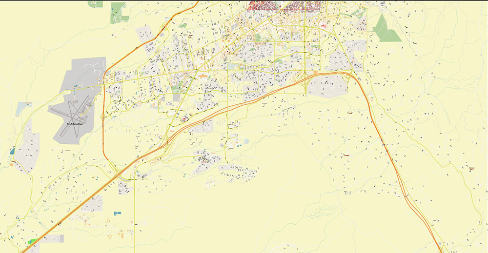
The city is served by the Santa Fe Municipal Airport IATA: SAF, ICAO: KSAF, located 17 kilometers southwest of the business center. Passenger traffic is about 50 thousand people a year, there are regular flights to Los Angeles, Dallas, and Denver. The nearest international airport is in Albuquerque. In the satellite city of Lamy, there is an Amtrak train station, where the Chicago–Los Angeles train stops daily, and there is a special express bus from the station to the center of Santa Fe. Only excursion trains and express trains from Albuquerque stop at the train station in Santa Fe itself. Interstate 25 passes through Santa Fe. Other important roads: US 84 and US 285. Public transport is represented by the city’s 8 routes and commuter buses operated by Santa Fe Trails.
6. Attractions
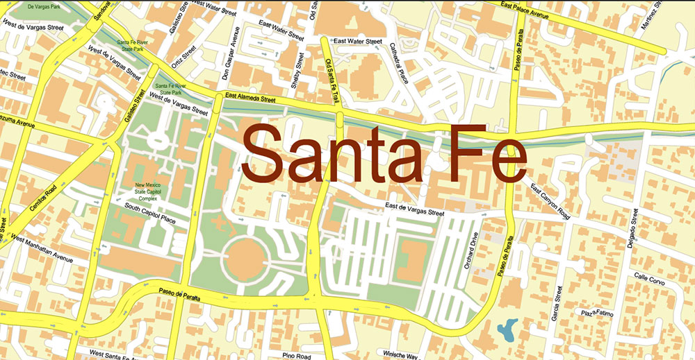
One of the most beautiful streets in Santa Fe is Canyon Road. This street is an open-air exhibition and fair. Almost every house has a small shop. Everything from stylized shoes and clothing to souvenirs and abstract paintings is on sale. Many courtyards are beautifully decorated with sculptures or installations. Canyon Road is located quite far from the city center. The Loretto Chapel of the former Roman Catholic church in Santa Fe is now used as a museum and as a hall for wedding ceremonies. It is famous for its unusual wooden spiral staircase in the form of a spiral “Wonderful Staircase“. Currently, the ladder is considered too dangerous for permanent use.
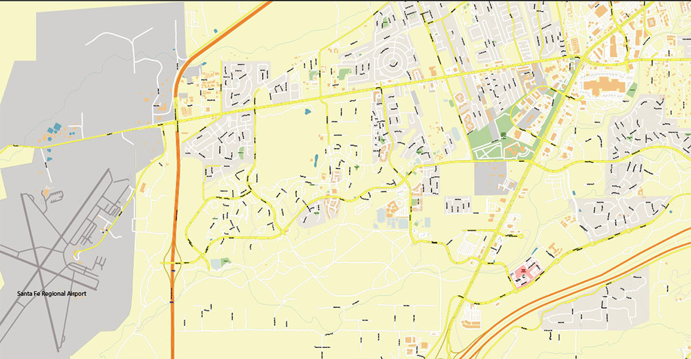
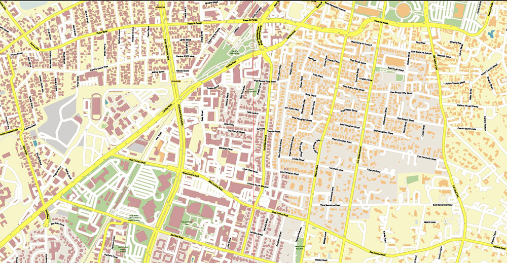
Printable Vector Map of Santa Fe New Mexico US detailed City Plan scale 1:3816 full editable Adobe Illustrator Street Map in layers, scalable, text format all names, 7 MB ZIP
All street names, Main Objects, Buildings. Map for design, printing, arts, projects, presentations, for architects, designers, and builders, business, logistics.
Included: Additional layers (buildings 2), boundaries of lots (parts), parts of roads as polygon, simple map of New Mexico.
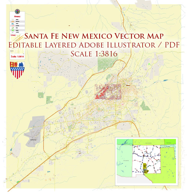
Santa Fe New Mexico US Map Vector Exact City Plan High Detailed Street Map editable Adobe Illustrator in layers
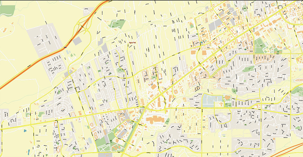
Layers list:
- Legend
- Grids
- Labels of roads
- Names of places (city, hamlet, etc.)
- Names of objects (hospitals, parks, water)
- Names of main streets
- Names of civil streets
- Main Streets, roads
- Civil streets
- Railroads
- Buildings
- Buildings 2
- Boundaries of lots (part)
- Streets and roads polygons (part)
- Airports and heliports
- Water objects (rivers, lakes, ponds)
- Waterways
- Color fills (parks, hospital areas, land use, etc.)
- Background
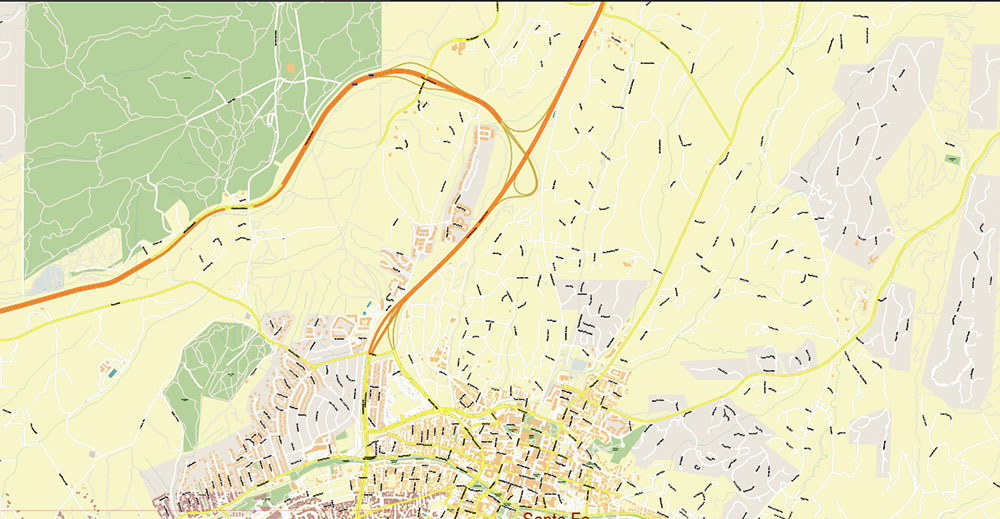
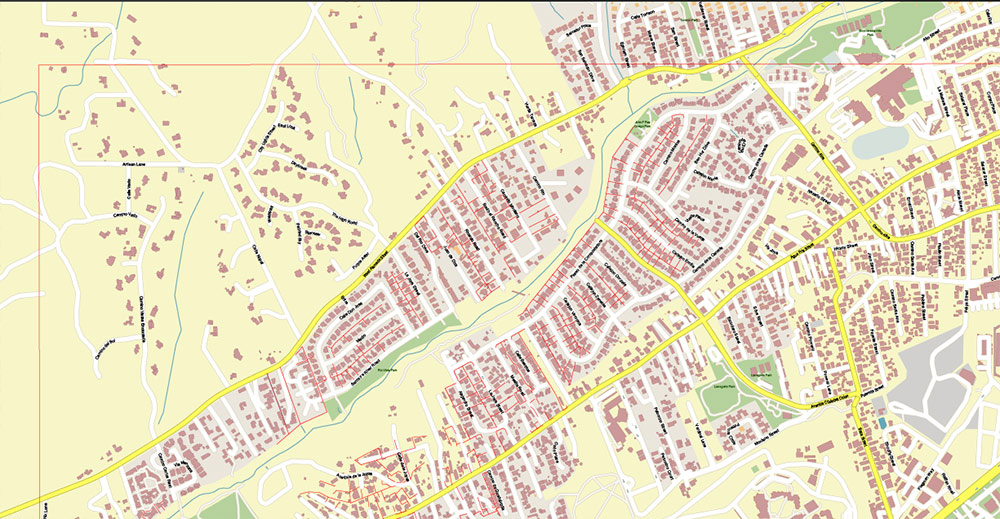
Santa Fe New Mexico US Map Vector Exact City Plan High Detailed Street Map editable Adobe Illustrator in layers
Santa Fe New Mexico US Map Vector Exact City Plan High Detailed Street Map editable Adobe Illustrator in layers
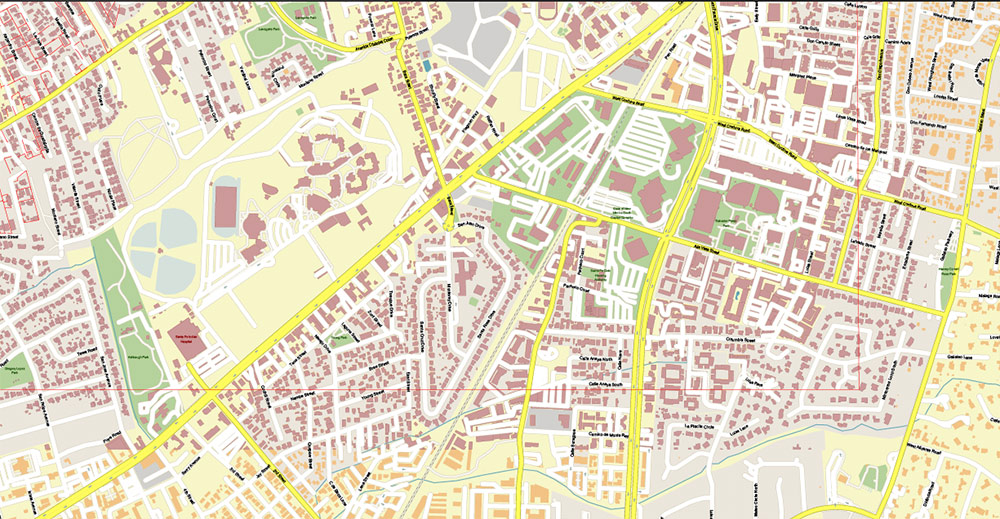
Santa Fe New Mexico US Map Vector Exact City Plan High Detailed Street Map editable Adobe Illustrator in layers
Santa Fe New Mexico US Map Vector Exact City Plan High Detailed Street Map editable Adobe Illustrator in layers
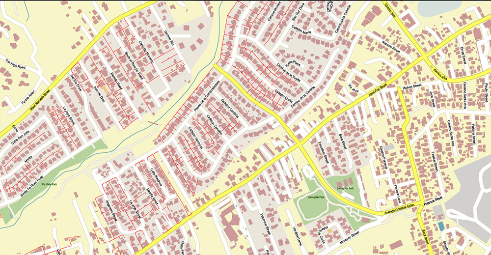
Santa Fe New Mexico US Map Vector Exact City Plan High Detailed Street Map editable Adobe Illustrator in layers
Santa Fe New Mexico US Map Vector Exact City Plan High Detailed Street Map editable Adobe Illustrator in layers
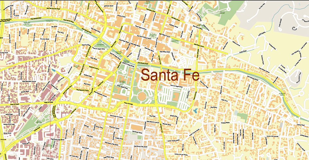
Santa Fe New Mexico US Map Vector Exact City Plan High Detailed Street Map editable Adobe Illustrator in layers
Santa Fe New Mexico US Map Vector Exact City Plan High Detailed Street Map editable Adobe Illustrator in layers
Santa Fe New Mexico US Map Vector Exact City Plan High Detailed Street Map editable Adobe Illustrator in layers
Santa Fe New Mexico US Map Vector Exact City Plan High Detailed Street Map editable Adobe Illustrator in layers
Santa Fe New Mexico US Map Vector Exact City Plan High Detailed Street Map editable Adobe Illustrator in layers

 Author: Kirill Shrayber, Ph.D. FRGS

