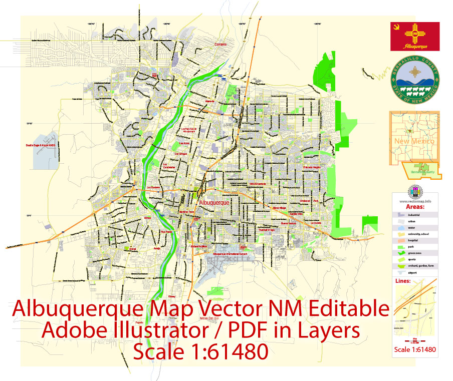
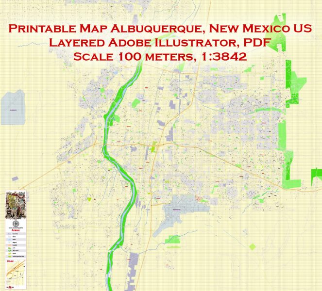
Printable Vector Map Albuquerque NM US, exact City Plan scale 1:61480 full editable Adobe Illustrator Street Map in layers, scalable, editable text format street names, 2 mb ZIP
Principal streets names, Main Objects. Map for design, printing, arts, projects, presentations, for architects, designers and builders, business, logistics.
Layers: color_fills, streets_roads, labels_roads, names_objects, names_streets, names_places, grids, halo 1-2, water objects, legend.
The most exact and detailed map of the city in scale.
For High Quality Printing Large or Small format.
DWG, DXF and other formats – on request, same price, please, contact
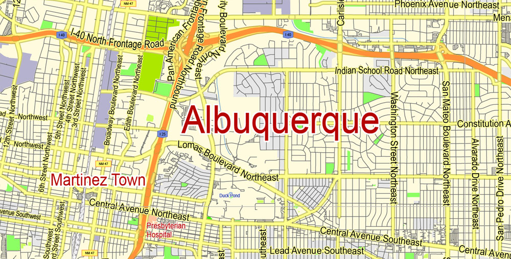
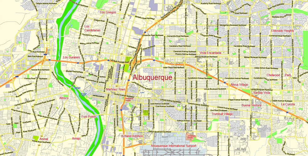
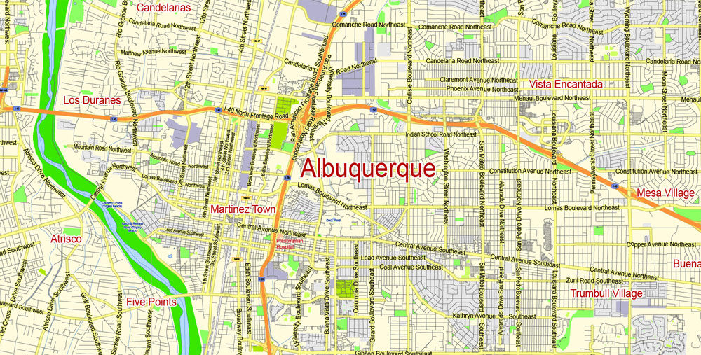
Albuquerque, New Mexico, USA.
This vector map of Albuquerque city is used as a basis for design, editing, and further printing.
This is the most detailed, exact map of Albuquerque city for high-quality printing and polygraphy. You can always clarify the map development date by contacting us.
For your convenience, all objects on Albuquerque vector city map are divided into layers. And the editing is very easy – colors, lines, etc.
You can easily add any objects needed (e.g. shops, salons, sale points, gas station or attraction) on any layer of Albuquerque vector map.
One of the advantages of Albuquerque city vector maps of our production is the relevance of cartographic data, we constantly update all our products.
Albuquerque is the most populous city in the U.S. state of New Mexico and the 32nd-most populous city in the United States, with a census-estimated population of 558,545 in 2017. Albuquerque is the principal city of the Albuquerque metropolitan area which has 910,726 residents as of July 2017.
This vector map of Albuquerque city is used by:
designers, layout designers, printers, advertisers and architects. Our product – vector maps – is designed for further editing and printing in large formats – from @Wall format (a few meters) to A-0 and A-1, A-2, A-3.
The Albuquerque city map in vector format is used for design, urban planning, presentations and media visualizations.
The advertising and presentation map of Albuquerque city (usually the final designer marks the routes, and puts the client’s objects (shops, saloons, gas stations etc.)
The undoubted advantage is that people will NEVER throw out this advertising product – the map. In fact, as an advertising medium, a city map is the most “long-playing” of the well-known polygraphic advertising media, with the longest lifespan, and the maximum number of interactions with the customer.
For travelers, maps are sold at the airports and gas stations around the world. Often the source is our vector maps.
Albuquerque’s MSA is the 60th-largest metropolitan area in the United States. The Albuquerque MSA population includes the cities of Rio Rancho, Bernalillo, Placitas, Corrales, Los Lunas, Belen, Bosque Farms, and forms part of the larger Albuquerque–Santa Fe–Las Vegas combined statistical area, with a total population of 1,171,991 in 2016.
Take a look, who purchases our vector maps of Albuquerque city in “Our Clients and Friends” page – these are large and small companies, from super-brands like Volvo and Starbucks, to small design studios and printing houses.
It’s very easy to work with vector maps of Albuquerque city, even for a not very experienced designer who can turn on and off the map layers, add new objects, change the colors of fill and lines according to customer requirements.
The undoubted advantage of Albuquerque city vector maps in printing is an excellent and detailed visualization, when customer can expand a large paper map and instantly define his location, find a landmark, an object or address on map, unlike using the popular electronic formats of Google and Yandex maps for example.
The city was named in honor of Francisco Fernández de la Cueva, 10th Duke of Alburquerque who was Viceroy of New Spain from 1702 to 1711. The growing village was named by provincial governor, Francisco Cuervo y Valdés. The Duke’s title referred to the Spanish town of Alburquerque, in the province of Badajoz, near the border with Portugal.
Printable vector maps of Albuquerque city are much more convenient and efficient than any electronic maps on your smartphone, because ALL DETAILS are displayed in the entire space of Albuquerque city map.
Useful tips on working with vector maps of cities and countries in Adobe Illustrator.
«V» – launches the Selection tool (cursor, black arrow), which makes active any vector line.
«А» – launches the Direct Selection tool (white cursor), allows you to select curve elements and drag them to the desired place.
«R» – activates the Rotate tool, which helps you rotating selected objects around the center point by 360 degrees.
«E» – gives you the opportunity to use the Eraser tool and erase unnecessary parts.
«X» – switches between Fill and Stroke in the Tools section. Try to get used to this hot key and
you will quickly understand that you can’t live and work without it.
Albuquerque serves as the county seat of Bernalillo County, and is situated in the north central part of the state. The Sandia Mountains run along the eastern side of Albuquerque, and the Rio Grande flows through the city. Albuquerque has one of the highest elevations of any major city in the U.S. with ranges from 4,900 feet (1,490 m) above sea level near the Rio Grande to over 6,700 feet (1,950 m) in the foothill areas of Sandia Heights and Glenwood Hills.
Guides are not limited to vertical and horizontal in Adobe Illustrator. You can also create a diagonal guide for example. Moreover, you can turn any contours into guides. Select the outline and go to View > Guides > Make Guides (Create Guides), or simply press Cmd/Ctrl + 5. You can also turn the guides back into an editable object. Go to menu, View > Guides > Unlock Guides (Release Guides), select the guide you want to edit and select View > Guides > Release Guides (Reset Guides), or just press Cmd/Ctrl + Option / Alt + 5).
Albuquerque is home to institutions and monuments such as Kirtland Air Force Base, Sandia National Laboratories, the National Museum of Nuclear Science & History, Lovelace Respiratory Research Institute, the University of New Mexico, Central New Mexico Community College, Presbyterian Medical Services, Presbyterian Health Services, the New Mexico Museum of Natural History and Science, Albuquerque Biological Park, and the Petroglyph National Monument. The city is the location of the New Mexico Technology Corridor, a concentration of high-tech private companies and government institutions. Albuquerque is also the home of the International Balloon Fiesta, the world’s largest such gathering of hot-air balloons from around the globe, taking place every October.
You will probably want to change the color scheme used on our Albuquerque vector city map.
To quickly and effectively play with colors.
Of course, you can do it manually, all objects in our Albuquerque city vector map are divided according to types and layers, and you can easily change the color gamma of vector objects in groups and layers.
Geography
According to the United States Census Bureau, Albuquerque has a total area of 189.5 square miles (490.9 km2), of which 187.7 square miles (486.2 km2) is land and 1.8 square miles (4.7 km2), or 0.96%, is water.
But there is more effective way of working with the whole VECTOR MAP of Albuquerque city and all layers:
The overview dialog «Edit colors»/«Repaint Graphic Object» (this dialog box name can change depending on the context):
If you have selected a part or a layer of Albuquerque city vector map and open the dialog box by clicking the icon in the Control panel, on the Samples palette or the Color Catalog, or if you choose Edit > Edit Colors> Repaint Graphic Object, then the «Repaint Graphic Object» dialog box appears, and you get access to «Assign» and «Edit» tabs.
If a picture or a map fragment is not selected, and you open the dialog box by clicking the icon in the Control panel, on the Samples palette or in the Color Catalog, the «Edit Colors» dialog box appears and you can only access the «Edit» tab.
Regardless of the name at the top of the dialog box, the right-hand side always displays the color group of the current document, as well as two default color groups: Print Color and Grayscale. These color groups can be selected and used any time.
Create and edit color groups of Albuquerque city vector map, and also assign colors using the «Edit Colors»/ а «Repaint Graphic Object» dialog box.
A. Creating and editing of a color group on the «Edit» tab
B. Assigning colors on the «Assign» tab
C. Select a group of colors from the «Color groups» list
The option «Repaint a graphic object» in the lower part of the dialog box allows you to preview the colors on a selected layer of Vector map, or a group of elements, and specify whether its colors will be redefined when the dialog box is closed.
Albuquerque lies within the northern, upper edges of the Chihuahuan Desert ecoregion, based on long-term patterns of climate, associations of plants and wildlife, and landforms, including drainage patterns. Located in central New Mexico, the city also has noticeable influences from the adjacent Colorado Plateau semi-desert, Arizona-New Mexico Mountains, and Southwest plateaus and plains steppe ecoregions, depending on where one is located. Its main geographic connection lies with southern New Mexico, while culturally, Albuquerque is a crossroads of most of New Mexico.
The main areas of the dialog box are:
«Edit»
The «Edit» tab is designed to create a new or edit the existing color groups.
The harmony rules Menu and the Color Wheel are used to conduct experiments with color harmonies. The color wheel shows how colors are related in color harmony, and the color bars allow you to view and manipulate an individual color values. In addition, you can adjust the brightness, add and remove colors, save color groups and view colors on the selected Vector Map of Albuquerque city or a separated layers.
«Assign»
The «Assign» tab is used to view and control on how the original colors are replaced with colors from the color group like your corporate colors in the Vector Map of Albuquerque city.
The assign color ability is provided only if the entire map, layer or fragment is selected in the document. You can specify which of new colors replace the current colors, whether the spot colors should be preserved and how colors are replaced (for example, you can replace colors completely or changing the color tone while maintaining the brightness). The «Assign» tab allows you to redefine colors in the Vector Map of Albuquerque city, or in separate layers and fragments using the current color group or reducing the number of colors in the current Vector Map.
Color groups
Is a list of all saved color groups for current document (the same groups appear in the «Samples» palette). You can edit and delete the existing color groups, as well as creating a new ones using the list of “Color Groups” in the dialog box. All changes appear in the «Samples» palette.
The highlighted color group shows, which color group is currently edited.
Any color group can be selected and edited, or used to redefine the colors in the selected vector map of Albuquerque city, its fragments or elements.
Saving a color group adds this group to the specified list.
Opening the «Edit Colors»/«Repaint Graphic Object» dialog box.
Open the «Edit Colors»/«Repaint Graphic Object» dialog box using one of the following methods:
«Edit»> «Edit Colors»> «Repaint Graphic object» or «Repaint With Style».
Use these commands if you need to edit the colors in the selected vector map of Albuquerque city.
«Repaint Graphic object» button on the «Control» panel.
Use this button if you need to adjust colors of Albuquerque city vector map using the а «Repaint graphic object» dialog box.
The specified button is available if the selected vector map or its fragment contains two or more colors.
Note. This color editing method is convenient for global color adjustment in a vector map, if global colors were not used when creating a City Map of Albuquerque.
The «Edit colors» button or «Edit or apply colors» on the «Color Catalog» palette
Click this button if you need to edit colors on the «Color Catalog» palette or edit and then apply them to the selected Vector Map of Albuquerque city or its fragment.
The «Edit color group» button or «Edit or apply color group» on the «Samples» palette.
Click this button if you need to edit the colors in the specific color group or edit and apply them to the selected Vector Map of Albuquerque city or a group of its elements, for example, the whole layer “Streets and lines”. You can also double-click the color group in the Samples panel to open the dialog box.
If the map file is too large and your computer freezes or even can’t open it quickly:
1. Try to reduce the color resolution of the video card (display) to 256 colors while working with a large map.
2. Using Windows Task Manager, select all the application you don’t need, while working with map, just turn them off.
3. Launch Adobe Illustrator. (DO NOT OPEN the vector map file)
4. Start the Windows Task Manager using administrator rights > Find the “Illustrator” process > set the «real time» priority,
5. Open the file. When you see the LEGACY FONT popup window – click “OK” (do not update). You can restore the TEXT later.
6. Can also be useful: When file is opened – Edit > Settings > Basic Settings > disable smoothing. /// It looks scary, but works quickly)))
We recommend saving the file in Adobe Illustrator 10 version. It’s much more stable when working with VERY BIG size files.
Albuquerque has one of the highest elevations of any major city in the United States, though the effects of this are greatly tempered by its southwesterly continental position. The elevation of the city ranges from 4,900 feet (1,490 m) above sea level near the Rio Grande (in the Valley) to over 6,700 feet (1,950 m) in the foothill areas of Sandia Heights and Glenwood Hills. At the airport, the elevation is 5,352 feet (1,631 m) above sea level.
The Rio Grande is classified, like the Nile, as an “exotic” river because it flows through a desert. The New Mexico portion of the Rio Grande lies within the Rio Grande Rift Valley, bordered by a system of faults, including those that lifted up the adjacent Sandia and Manzano Mountains, while lowering the area where the life-sustaining Rio Grande now flows.
Cityscape
Quadrants
Albuquerque is geographically divided into four quadrants which are officially part of the mailing address. They are NE (northeast), NW (northwest), SE (southeast), and SW (southwest). The north-south dividing line is Central Avenue (the path that Route 66 took through the city) and the east-west dividing line is the Rail Runner tracks.
Northeast Quadrant
This quadrant has been experiencing a housing expansion since the late 1950s. It abuts the base of the Sandia Mountains and contains portions of the foothills neighborhoods, which are significantly higher, in elevation and price range, than the rest of the city. Running from Central Avenue and the railroad tracks to the Sandia Peak Aerial Tram, this is the largest quadrant both geographically and by population. The University of New Mexico, the Maxwell Museum of Anthropology, Nob Hill, the Uptown area which includes two shopping malls (Coronado Center and ABQ Uptown), Hoffmantown, Journal Center, Cliff’s Amusement Park, and Balloon Fiesta Park are all located in this quadrant.
Some of the most affluent neighborhoods in the city are located here, including: High Desert, Tanoan, Sandia Heights, and North Albuquerque Acres. Parts of Sandia Heights and North Albuquerque Acres are outside the city limits proper. A few houses in the farthest reach of this quadrant lie in the Cibola National Forest, just over the line into Sandoval County.
Northwest Quadrant
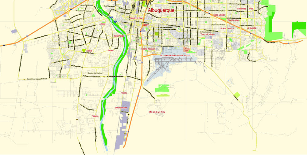
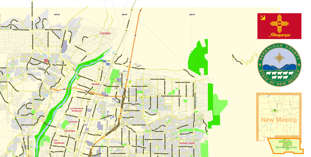
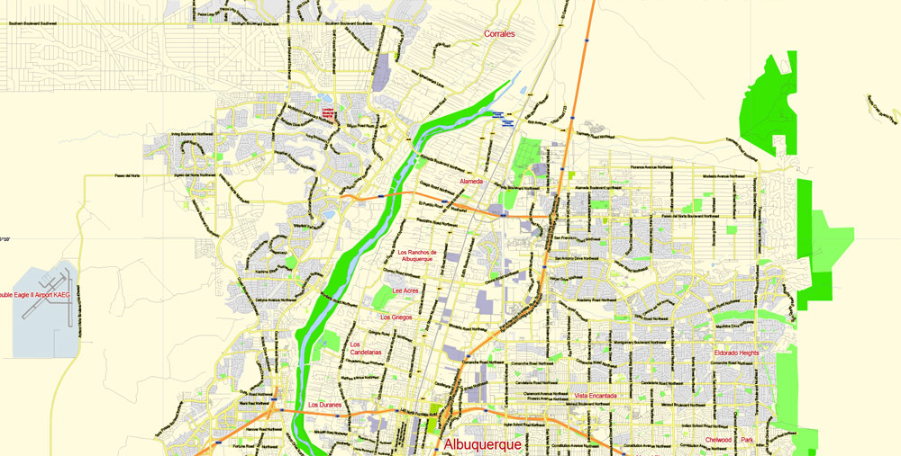
This quadrant contains historic Old Town Albuquerque, which dates back to the 18th century, as well as the Indian Pueblo Cultural Center. The area has a mixture of commercial districts and low to middle-income neighborhoods. Northwest Albuquerque includes the largest section of Downtown, Rio Grande Nature Center State Park and the Bosque (“woodlands”), Petroglyph National Monument, Double Eagle II Airport, Martineztown, the Paradise Hills neighborhood, Taylor Ranch, and Cottonwood Mall.
Additionally, the North Valley settlement, outside the city limits, which has some expensive homes and small ranches along the Rio Grande, is located here. The city of Albuquerque engulfs the village of Los Ranchos de Albuquerque. A small portion of the rapidly developing area on the west side of the river south of the Petroglyphs, known as the “West Mesa” or “Westside”, consisting primarily of traditional residential subdivisions, also extends into this quadrant. The city proper is bordered on the north by the North Valley, the village of Corrales, and the city of Rio Rancho.
Southeast Quadrant
Kirtland Air Force Base, Sandia National Laboratories, Sandia Science & Technology Park, Albuquerque International Sunport, Eclipse Aerospace, American Society of Radiologic Technologists, Central New Mexico Community College, Albuquerque Veloport, University Stadium, Isotopes Park, The Pit, Mesa del Sol, The Pavilion, Albuquerque Studios, Isleta Resort & Casino, the National Museum of Nuclear Science & History, New Mexico Veterans’ Memorial, and Talin Market are all located in the Southeast quadrant.
The upscale neighborhood of Four Hills is located in the foothills of Southeast Albuquerque. Other neighborhoods include Nob Hill, Ridgecrest, Willow Wood, and Volterra.
Southwest Quadrant
Traditionally consisting of agricultural and rural areas and suburban neighborhoods, the Southwest quadrant comprises the south-end of Downtown Albuquerque, the Barelas neighborhood, the rapidly-growing west side, and the community of South Valley, New Mexico, often referred to as “The South Valley”. Although the city limits of Albuquerque do not include the South Valley, the quadrant extends through it all the way to the Isleta Indian Reservation. Newer suburban subdivisions on the West Mesa near the southwestern city limits join homes of older construction, some dating back as far as the 1940s. This quadrant includes the old communities of Atrisco, Los Padillas, Huning Castle, Kinney, Westgate, Westside, Alamosa, Mountainview, and Pajarito. The Bosque (“woodlands”), the National Hispanic Cultural Center, the Rio Grande Zoo, and Tingley Beach are also located here.
A new adopted development plan, the Santolina Master Plan, will extend development on the west side past 118th Street SW to the edge of the Rio Puerco Valley, and house 100,000 by 2050. It is unclear at this time whether the Santolina development will be annexed into the City of Albuquerque or incorporated into its own city when its development does occur.
Parks and recreation
According to the Trust for Public Land, Albuquerque has 291 public parks as of 2017, most of which are administered by the city Parks and Recreation Department. The total amount of parkland is 42.9 square miles (111 km2), or about 23% of the city’s total area—one of the highest percentages among large cities in the U.S. About 82% of city residents live within walking distance of a park.
Albuquerque has a botanical and zoological complex called the Albuquerque Biological Park, consisting of the Rio Grande Botanic Garden, Albuquerque Aquarium, Tingley Beach, and the Rio Grande Zoo.
Albuquerque
City in New Mexico
Albuquerque, New Mexico’s largest city (see also high detailed map of Albuququerque), sits in the high desert. Its modern Downtown core contrasts with Old Town Albuquerque, dating to the city’s 1706 founding as a Spanish colony. Old Town is filled with historic adobe buildings, such as San Felipe de Neri Church, 5 museums, and shops selling Native American handicrafts. Nearby, The Indian Pueblo Cultural Center traces the area’s tribal history.
Area
• City 189.5 sq mi (490.9 km2)
• Land 187.7 sq mi (486.2 km2)
• Water 1.8 sq mi (4.7 km2)
Elevation 5,312 ft (1,619.1 m)
Population
• City 545,852
• Estimate 558,545
• Rank US: 32nd
• Density 2,900/sq mi (1,100/km2)
• Metro 909,906 (60th)
1,171,991 (Albuquerque–Santa Fe–Las Vegas CSA)
• Ethnicities 69.7% White
4.6% Multiracial
4.6% American Indian
3.3% Black
2.6% Asian
46.7% Hispanic
See also high detailed map of Albuququerque
Free US vector maps

Free Download Vector Map US County and State Adobe Illustrator
Free_Vector_Map_US_States_County_Map.ai
Free Download Vector Map US County and State Adobe PDF
Free_Vector_Map_US_States_County_Map.pdf

Free Download Vector Map US With States Names, Adobe Illustrator
Free_Map_of_USA_with_state_names_en.ai
Free Download Vector Map US With States Names, Adobe PDF
Free_Map_of_USA_with_state_names_en.pdf
From WIKI
Free vector map World, Adobe Illustrator, download now maps vector clipart
Map for design, projects, presentation free to use as you like.
See also: TERMS & CONDITIONS: SOFTWARE LICENSE AGREEMENT FOR DIGITAL CARTOGRAPHIC DATA.
Need more USA Vector Maps, printable and editable?

 Author: Kirill Shrayber, Ph.D. FRGS


