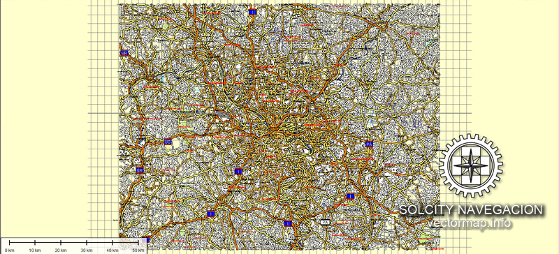
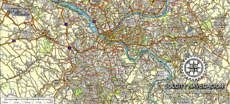
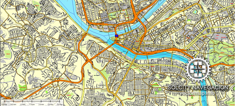
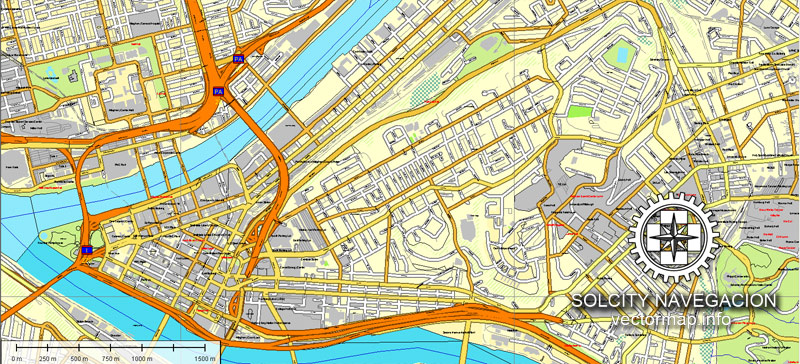
Pittsburgh, Pennsylvania, US printable vector street Atlas 25 parts map, full editable, Adobe Illustrator, full vector A-0, scalable, editable, text format street names, 49,8 mb ZIP
Montage: A-1 ~ E-5
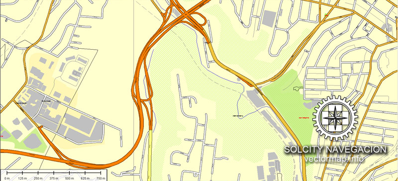
All streets, some buildings. Map for design, print, arts, projects, presentations.
PDF, DXF, CDR and other formats – on request, same price, please, contact
Pittsburgh, Pennsylvania, USA.
This vector map of Pittsburgh city is used as a basis for design, editing, and further printing.
This is the most detailed, exact map of Pittsburgh city for high-quality printing and polygraphy. You can always clarify the map development date by contacting us.
For your convenience, all objects on Pittsburgh vector city map are divided into layers. And the editing is very easy – colors, lines, etc.
You can easily add any objects needed (e.g. shops, salons, sale points, gas station or attraction) on any layer of Pittsburgh vector map.
Pittsburgh is a city in the Commonwealth of Pennsylvania in the United States, and is the county seat of Allegheny County. As of 2017, a population of 305,704 lives within the city limits, making it the 63rd-largest city in the U.S. The metropolitan population of 2,353,045 is the largest in both the Ohio Valley and Appalachia, the second-largest in Pennsylvania (behind Philadelphia), and the 26th-largest in the U.S.
One of the advantages of Pittsburgh city vector maps of our production is the relevance of cartographic data, we constantly update all our products.
This vector map of Pittsburgh city is used by:
designers, layout designers, printers, advertisers and architects. Our product – vector maps – is designed for further editing and printing in large formats – from @Wall format (a few meters) to A-0 and A-1, A-2, A-3.
The Pittsburgh city map in vector format is used for design, urban planning, presentations and media visualizations.
The advertising and presentation map of Pittsburgh city (usually the final designer marks the routes, and puts the client’s objects (shops, saloons, gas stations etc.)
The undoubted advantage is that people will NEVER throw out this advertising product – the map. In fact, as an advertising medium, a city map is the most “long-playing” of the well-known polygraphic advertising media, with the longest lifespan, and the maximum number of interactions with the customer.
Located at the confluence of the Allegheny, Monongahela, and Ohio rivers, Pittsburgh is known both as “the Steel City” for its more than 300 steel-related businesses and as the “City of Bridges” for its 446 bridges. The city features 30 skyscrapers, two inclined railways, a pre-revolutionary fortification and the Point State Park at the confluence of the rivers. The city developed as a vital link of the Atlantic coast and Midwest, as the mineral-rich Allegheny Mountains made the area coveted by the French and British empires, Virginians, Whiskey Rebels, and Civil War raiders.
For travelers, maps are sold at the airports and gas stations around the world. Often the source is our vector maps.
Take a look, who purchases our vector maps of Pittsburgh city in “Our Clients and Friends” page – these are large and small companies, from super-brands like Volvo and Starbucks, to small design studios and printing houses.
It’s very easy to work with vector maps of Pittsburgh city, even for a not very experienced designer who can turn on and off the map layers, add new objects, change the colors of fill and lines according to customer requirements.
The undoubted advantage of Pittsburgh city vector maps in printing is an excellent and detailed visualization, when customer can expand a large paper map and instantly define his location, find a landmark, an object or address on map, unlike using the popular electronic formats of Google and Yandex maps for example.
Printable vector maps of Pittsburgh city are much more convenient and efficient than any electronic maps on your smartphone, because ALL DETAILS are displayed in the entire space of Pittsburgh city map.
Aside from steel, Pittsburgh has led in manufacturing of aluminum, glass, shipbuilding, petroleum, foods, sports, transportation, computing, autos, and electronics. For part of the 20th century, Pittsburgh was behind only New York and Chicago in corporate headquarters employment; it had the most U.S. stockholders per capita. America’s 1980s deindustrialization laid off area blue-collar workers and thousands of downtown white-collar workers when the longtime Pittsburgh-based world headquarters moved out. This heritage left the area with renowned museums, medical centers, parks, research centers, and a diverse cultural district.
Useful tips on working with vector maps of cities and countries in Adobe Illustrator.
«V» – launches the Selection tool (cursor, black arrow), which makes active any vector line.
«А» – launches the Direct Selection tool (white cursor), allows you to select curve elements and drag them to the desired place.
«R» – activates the Rotate tool, which helps you rotating selected objects around the center point by 360 degrees.
«E» – gives you the opportunity to use the Eraser tool and erase unnecessary parts.
«X» – switches between Fill and Stroke in the Tools section. Try to get used to this hot key and
you will quickly understand that you can’t live and work without it.
Guides are not limited to vertical and horizontal in Adobe Illustrator. You can also create a diagonal guide for example. Moreover, you can turn any contours into guides. Select the outline and go to View > Guides > Make Guides (Create Guides), or simply press Cmd/Ctrl + 5. You can also turn the guides back into an editable object. Go to menu, View > Guides > Unlock Guides (Release Guides), select the guide you want to edit and select View > Guides > Release Guides (Reset Guides), or just press Cmd/Ctrl + Option / Alt + 5).
Today, Google, Apple Inc., Bosch, Facebook, Uber, Nokia, Autodesk, Microsoft and IBM are among 1,600 technology firms generating $20.7 billion in annual Pittsburgh payrolls. The area has served as the long-time federal agency headquarters for cyber defense, software engineering, robotics, energy research and the nuclear navy. The area is home to 68 colleges and universities, including research and development leaders Carnegie Mellon University and the University of Pittsburgh. The nation’s eighth-largest bank, eight Fortune 500 companies, and six of the top 300 U.S. law firms make their global headquarters in the area, while RAND, BNY Mellon, Nova, FedEx, Bayer and NIOSH have regional bases that helped Pittsburgh become the sixth-best area for U.S. job growth.
You will probably want to change the color scheme used on our Pittsburgh vector city map.
To quickly and effectively play with colors.
Of course, you can do it manually, all objects in our Pittsburgh city vector map are divided according to types and layers, and you can easily change the color gamma of vector objects in groups and layers.
But there is more effective way of working with the whole VECTOR MAP of Pittsburgh city and all layers:
The overview dialog «Edit colors»/«Repaint Graphic Object» (this dialog box name can change depending on the context):
If you have selected a part or a layer of Pittsburgh city vector map and open the dialog box by clicking the icon in the Control panel, on the Samples palette or the Color Catalog, or if you choose Edit > Edit Colors> Repaint Graphic Object, then the «Repaint Graphic Object» dialog box appears, and you get access to «Assign» and «Edit» tabs.
In 2015, Pittsburgh was listed among the “eleven most livable cities in the world”; The Economist’s Global Liveability Ranking placed Pittsburgh as the first- or second-most livable city in the United States in 2005, 2009, 2011, 2012 and 2014. The region is a hub for Leadership in Energy and Environmental Design and energy extraction.
If a picture or a map fragment is not selected, and you open the dialog box by clicking the icon in the Control panel, on the Samples palette or in the Color Catalog, the «Edit Colors» dialog box appears and you can only access the «Edit» tab.
Regardless of the name at the top of the dialog box, the right-hand side always displays the color group of the current document, as well as two default color groups: Print Color and Grayscale. These color groups can be selected and used any time.
Create and edit color groups of Pittsburgh city vector map, and also assign colors using the «Edit Colors»/ а «Repaint Graphic Object» dialog box.
A. Creating and editing of a color group on the «Edit» tab
B. Assigning colors on the «Assign» tab
C. Select a group of colors from the «Color groups» list
The option «Repaint a graphic object» in the lower part of the dialog box allows you to preview the colors on a selected layer of Vector map, or a group of elements, and specify whether its colors will be redefined when the dialog box is closed.
Geography
Pittsburgh has an area of 58.3 square miles (151 km2), of which 55.6 square miles (144 km2) is land and 2.8 square miles (7.3 km2) (or 4.75%) is water. The 80th meridian west passes directly through the city’s downtown.
The main areas of the dialog box are:
«Edit»
The «Edit» tab is designed to create a new or edit the existing color groups.
The harmony rules Menu and the Color Wheel are used to conduct experiments with color harmonies. The color wheel shows how colors are related in color harmony, and the color bars allow you to view and manipulate an individual color values. In addition, you can adjust the brightness, add and remove colors, save color groups and view colors on the selected Vector Map of Pittsburgh city or a separated layers.
«Assign»
The «Assign» tab is used to view and control on how the original colors are replaced with colors from the color group like your corporate colors in the Vector Map of Pittsburgh city.
The assign color ability is provided only if the entire map, layer or fragment is selected in the document. You can specify which of new colors replace the current colors, whether the spot colors should be preserved and how colors are replaced (for example, you can replace colors completely or changing the color tone while maintaining the brightness). The «Assign» tab allows you to redefine colors in the Vector Map of Pittsburgh city, or in separate layers and fragments using the current color group or reducing the number of colors in the current Vector Map.
The city is on the Allegheny Plateau, within the ecoregion of the Western Allegheny Plateau, The Downtown area (also known as the Golden Triangle) sits where the Allegheny River flowing from the northeast and Monongahela River from the southeast form the Ohio River. The convergence is at Point State Park and is referred to as “the Point.” The city extends east to include the Oakland and Shadyside sections, which are home to the University of Pittsburgh, Carnegie Mellon University, Chatham University, Carnegie Museum and Library, and many other educational, medical, and cultural institutions. The southern, western, and northern areas of the city are primarily residential.
Color groups
Is a list of all saved color groups for current document (the same groups appear in the «Samples» palette). You can edit and delete the existing color groups, as well as creating a new ones using the list of “Color Groups” in the dialog box. All changes appear in the «Samples» palette.
The highlighted color group shows, which color group is currently edited.
Any color group can be selected and edited, or used to redefine the colors in the selected vector map of Pittsburgh city, its fragments or elements.
Saving a color group adds this group to the specified list.
Opening the «Edit Colors»/«Repaint Graphic Object» dialog box.
Open the «Edit Colors»/«Repaint Graphic Object» dialog box using one of the following methods:
«Edit»> «Edit Colors»> «Repaint Graphic object» or «Repaint With Style».
Many Pittsburgh neighborhoods are steeply sloped with two-lane roads. More than a quarter of neighborhood names make reference to “hills,” “heights,” or similar features.
The steps of Pittsburgh consist of 712 sets of outdoor public stairways with 44,645 treads and 24,090 vertical feet. They include hundreds of streets composed entirely of stairs, and many other steep streets with stairs for sidewalks. Many provide vistas of the Pittsburgh area while attracting hikers and fitness walkers.
Use these commands if you need to edit the colors in the selected vector map of Pittsburgh city.
«Repaint Graphic object» button on the «Control» panel.
Use this button if you need to adjust colors of Pittsburgh city vector map using the а «Repaint graphic object» dialog box.
The specified button is available if the selected vector map or its fragment contains two or more colors.
Note. This color editing method is convenient for global color adjustment in a vector map, if global colors were not used when creating a City Map of Pittsburgh.
The «Edit colors» button or «Edit or apply colors» on the «Color Catalog» palette
Click this button if you need to edit colors on the «Color Catalog» palette or edit and then apply them to the selected Vector Map of Pittsburgh city or its fragment.
Bike and walking trails have been built to border many of the city’s rivers and hollows. The Great Allegheny Passage and Chesapeake and Ohio Canal Towpath connect the city directly to downtown Washington, D.C. (some 335 miles (539 km) away) with a continuous bike/running trail.
The «Edit color group» button or «Edit or apply color group» on the «Samples» palette.
Click this button if you need to edit the colors in the specific color group or edit and apply them to the selected Vector Map of Pittsburgh city or a group of its elements, for example, the whole layer “Streets and lines”. You can also double-click the color group in the Samples panel to open the dialog box.
If the map file is too large and your computer freezes or even can’t open it quickly:
1. Try to reduce the color resolution of the video card (display) to 256 colors while working with a large map.
2. Using Windows Task Manager, select all the application you don’t need, while working with map, just turn them off.
3. Launch Adobe Illustrator. (DO NOT OPEN the vector map file)
4. Start the Windows Task Manager using administrator rights > Find the “Illustrator” process > set the «real time» priority,
5. Open the file. When you see the LEGACY FONT popup window – click “OK” (do not update). You can restore the TEXT later.
6. Can also be useful: When file is opened – Edit > Settings > Basic Settings > disable smoothing. /// It looks scary, but works quickly)))
We recommend saving the file in Adobe Illustrator 10 version. It’s much more stable when working with VERY BIG size files.
The Pittsburgh-New Castle-Weirton, PA-OH-WV Combined Statistical Area is a 12-county Combined Statistical Area in the United States. The principal city of the area is the City of Pittsburgh, Pennsylvania but includes parts of the states of Pennsylvania, West Virginia, and Ohio and was officially defined by the U.S. Census Bureau in 2013. As a CSA, the Census Bureau has identified that the region shares integrated transportation and economic ties as evidenced by commuting patterns. The estimated population of the area was 2,635,228 in mid-2016.
The city consists of the Downtown area, called the Golden Triangle, and four main areas surrounding it. These surrounding areas are subdivided into distinct neighborhoods (Pittsburgh has 90 neighborhoods). Relative to downtown, these areas are known as the North Side, South Side/South Hills, East End, and West End.
Downtown Pittsburgh has 30 skyscrapers, nine of which top 500 feet (150 m). U.S. Steel Tower is the tallest at 841 ft (256 m). The Cultural District consists of a 14-block area of downtown along the Allegheny River. This district contains many theaters and arts venues and is home to a growing residential segment. Most significantly, the Pittsburgh Cultural Trust is embarking on RiverParc, a four-block mixed-use “green” community, featuring 700 residential units and multiple towers between 20 and 30 stories. The Firstside portion of downtown borders the Monongahela River, the historic Mon Wharf and hosts the distinctive PPG Place Gothic-style glass skyscraper complex. New condo towers have been constructed and historic office towers are converted to residential use, increasing 24-hour residents. Downtown is served by the Port Authority’s light rail system and multiple bridges leading north and south. It is also home to Point Park University and Duquesne University which borders Uptown.
North Side
The North Side is home to various neighborhoods in transition. What is known today as Pittsburgh’s North Side was once known as Allegheny City, and operated as a city independently of Pittsburgh. Allegheny City merged with Pittsburgh under great protest from its citizens. The North Side is primarily composed of residential neighborhoods and is noteworthy for well-constructed and architecturally interesting homes. Many buildings date from the 19th century and are constructed of brick or stone and adorned with decorative woodwork, ceramic tile, slate roofs and stained glass. The North Side is also home to many popular attractions such as Heinz Field, PNC Park, Carnegie Science Center, National Aviary, Andy Warhol Museum, Mattress Factory installation art museum, Children’s Museum of Pittsburgh, Randyland, Highmark SportsWorks, Penn Brewery, and Allegheny Observatory. The North Side is also home to Allegheny General Hospital, which is listed among the 1999 US News & World Report 2000 best hospitals nationwide.
South Side
The South Side was once the site of the Pennsylvania Railroad railyards and associated dense, inexpensive housing for mill and railroad workers. Since the late 20th century, the city undertook a Main Street program in cooperation with the National Trust for Historic Preservation, encouraging design and landscape improvements on East Carson Street, and supporting new retail. The area has become a local Pittsburgher destination. The South Side is one of the most popular neighborhoods in the city in which to own a home. The value of homes in the South Side has increased in value by about 10% annually for the past 10 years. East Carson Street has developed as one of the most vibrant areas of the city, packed with diverse shopping, ethnic eateries, vibrant nightlife, and live music venues.
In 1993 the Urban Redevelopment Authority of Pittsburgh purchased the South Side Works steel mill property. It collaborated with the community and various developers to create a master plan for a mixed-use development, to include a riverfront park, office space, housing, health-care facilities, and indoor practice fields for the Pittsburgh Steelers and Pitt Panthers. Construction began in 1998. The SouthSide Works has been open since 2005, featuring many stores, restaurants, offices, and the world headquarters for American Eagle Outfitters.
East End
The East End is home to the University of Pittsburgh, Carnegie Mellon University, Carlow University, Chatham University, The Carnegie Institute’s Museums of Art and Natural History, Frick Art & Historical Center (Clayton and the Frick art museum), Phipps Conservatory, Soldiers and Sailors Memorial Hall, and the Pittsburgh Zoo and PPG Aquarium. The neighborhoods of Shadyside and Squirrel Hill are large, wealthy neighborhoods with some apartments and condos. They enjoy pedestrian-oriented shopping/business districts. Oakland, heavily populated by undergraduate and graduate students, is home to most of the universities, Schenley Park and the Petersen Events Center. Bloomfield is Pittsburgh’s Little Italy and is known for its Italian restaurants and grocers. Lawrenceville is a revitalizing rowhouse neighborhood popular with artists and designers; it is expected to benefit from the recent new construction of a new Children’s Hospital. The Strip District to the west along the Allegheny River is an open-air marketplace by day and a clubbing destination by night. Other East End neighborhoods include Point Breeze, Homewood, Lincoln-Lemington-Belmar, Larimer, and Hazelwood.
West End
The West End includes Mt. Washington, with its famous view of the Downtown skyline and numerous other residential neighborhoods such as Sheraden and Elliott.
Small guide: How to work with the vector map?
You can: Mass select objects by type and color – for example, the objects type “building” (they are usually dark gray) – and remove them from the map, if you do not need them in your print or design project. You can also easily change the thickness of lines (streets), just bulk selection the road by the line color.
The streets are separated by type, for example, type “residential road” are usually white with a gray stroke. Highway usually orange with a brown or dark gray stroke.
It is easy to change the font of inscriptions, all or each individually. Also, just can be make and any other manipulation of objects on the vector map in Adobe illustrator format.
Important: All the proportions on the map are true, that is, the relative sizes of the objects are true, because Map is based on an accurate GPS projection, and It transated into the (usual for all) the Mercator projection.
You can easily change the color, stroke and fill of any object on the map, zoom without loss of quality Image Verification.
Select object

Bulk selection the same objects on the vector map

See the bulk selected objects on the vector map

Bulk delete buildungs from the vector map

Select residencial road (small street) on the vector map

Bulk selection the same lines (streets, roads) on the full map

Create fat lines of the streets on the vector maps (bulk action) 1

Create fat lines of the streets on the vector maps (bulk action) 2

Create fat lines of the streets on the vector maps (bulk action) 3

You can easily change the color, stroke and fill of any object on the map, zoom without loss of quality Image Verification.

 Author: Kirill Shrayber, Ph.D. FRGS


