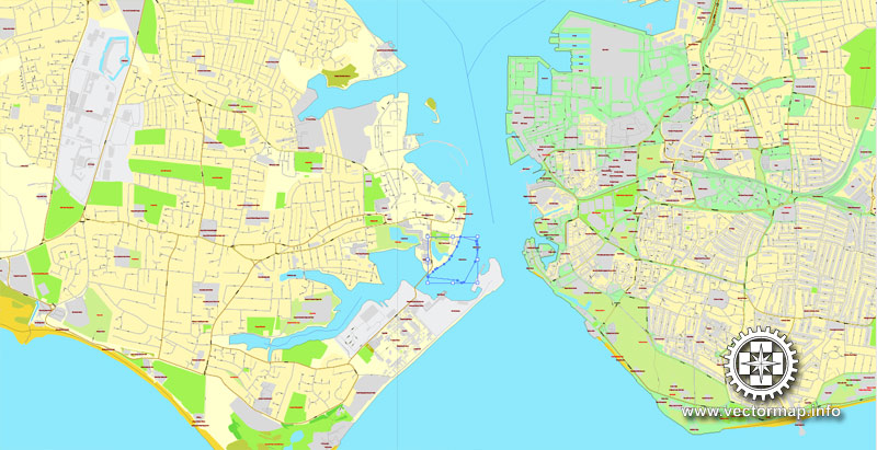
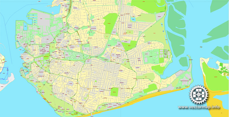
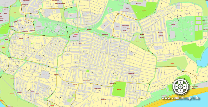
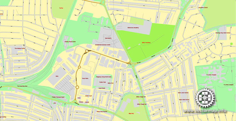
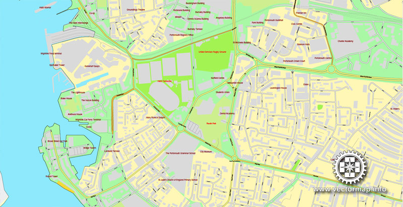
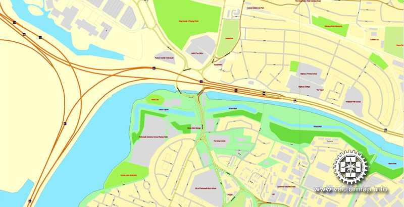
Portsmouth, England, printable vector street map, Exact City Plan full editable, Adobe PDF, Royalty free, full vector, scalable, editable, text format street names, 15 mb ZIP
All streets, All buildings.
Map for design, printing, publications, arts, projects, presentations, for architects, designers and builders, business, logistics. The most exact and detailed map of the city.
You can edit this file by Adobe Illustrator, Adobe Acrobat, Corel Draw.
Different font colors of the street names (black); object names by type (brown, red).
DXF, DWG, CDR and other formats – on request, same price, please, contact
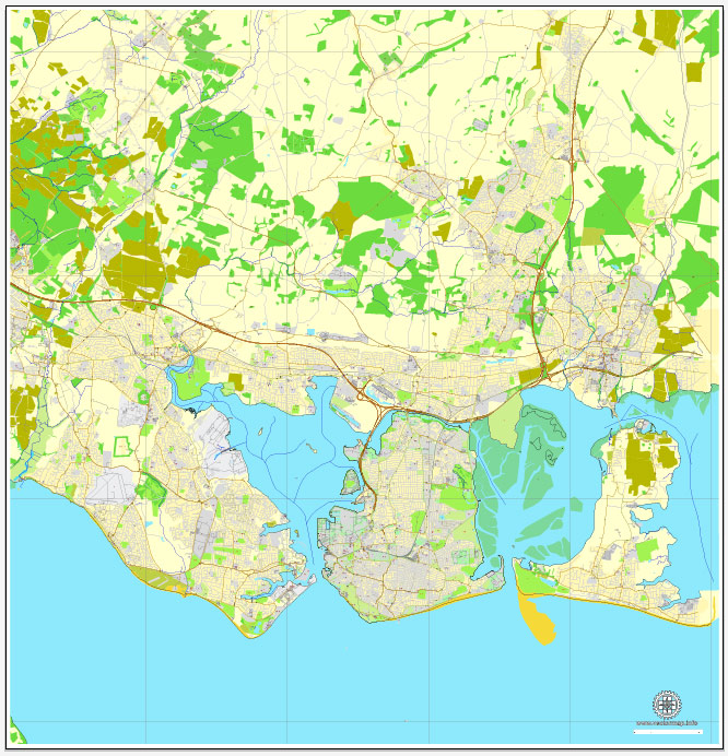
Portsmouth, UK.
This vector map of Portsmouth is used as a basis for design, editing, and further printing.
This is the most detailed, exact map of Portsmouth for high-quality printing and polygraphy. You can always clarify the map development date by contacting us.
For your convenience, all objects on Portsmouth vector map are divided into layers. And the editing is very easy – colors, lines, etc.
You can easily add any objects needed (e.g. shops, salons, sale points, gas station or attraction) on any layer of Portsmouth vector map.
Portsmouth is a port city in Hampshire, England, with a total population of 205,400 residents. The city of Portsmouth is nicknamed Pompey and is mainly built on Portsea Island, a flat, low-lying island measuring 24 square kilometres (9 sq mi) in area, just off the south-east coast of Hampshire. Uniquely, Portsmouth is the only island city in the United Kingdom, and is the only city whose population density exceeds that of London.
One of the advantages of Portsmouth vector maps of our production is the relevance of cartographic data, we constantly update all our products.
This vector map of Portsmouth is used by:
designers, layout designers, printers, advertisers and architects. Our product – vector maps – is designed for further editing and printing in large formats – from @Wall format (a few meters) to A-0 and A-1, A-2, A-3.
Portsmouth map in vector format is used for design, urban planning, presentations and media visualizations.
Advertising and presentation map of Portsmouth (usually the final designer marks the routes, and puts the client’s objects (shops, saloons, gas stations etc.)
The undoubted advantage is that people will NEVER throw out this advertising product – the map. In fact, as an advertising medium, a map is the most “long-playing” of the well-known polygraphic advertising media, with the longest lifespan, and the maximum number of interactions with the customer.
For travelers, maps are sold at the airports and gas stations around the world. Often the source is our vector maps.
Take a look, who purchases our vector maps of Portsmouth in “Our Clients and Friends” page – these are large and small companies, from super-brands like Volvo and Starbucks, to small design studios and printing houses.
It’s very easy to work with vector maps of Portsmouth, even for a not very experienced designer who can turn on and off the map layers, add new objects, change the colors of fill and lines according to customer requirements.
The undoubted advantage of Portsmouth vector maps in printing is an excellent and detailed visualization, when customer can expand a large paper map and instantly define his location, find a landmark, an object or address on map, unlike using the popular electronic formats of Google and Yandex maps for example.
Printable vector maps of Portsmouth are much more convenient and efficient than any electronic maps on your smartphone, because ALL DETAILS are displayed in the entire space of Portsmouth map.
Useful tips on working with vector maps of cities and countries in Adobe Illustrator.
«V» – launches the Selection tool (cursor, black arrow), which makes active any vector line.
«А» – launches the Direct Selection tool (white cursor), allows you to select curve elements and drag them to the desired place.
«R» – activates the Rotate tool, which helps you rotating selected objects around the center point by 360 degrees.
«E» – gives you the opportunity to use the Eraser tool and erase unnecessary parts.
«X» – switches between Fill and Stroke in the Tools section. Try to get used to this hot key and
you will quickly understand that you can’t live and work without it.
Guides are not limited to vertical and horizontal in Adobe Illustrator. You can also create a diagonal guide for example. Moreover, you can turn any contours into guides. Select the outline and go to View > Guides > Make Guides (Create Guides), or simply press Cmd/Ctrl + 5. You can also turn the guides back into an editable object. Go to menu, View > Guides > Unlock Guides (Release Guides), select the guide you want to edit and select View > Guides > Release Guides (Reset Guides), or just press Cmd/Ctrl + Option / Alt + 5).
Portsmouth is located 70 miles (110 km) south-west of London and 19 miles (31 km) south-east of Southampton. With the surrounding towns of Gosport, Fareham, Havant and Waterlooville, Portsmouth forms the eastern half of the South Hampshire metropolitan area, which includes Southampton and Eastleigh in the western half.
You will probably want to change the color scheme used on our Portsmouth vector map.
To quickly and effectively play with colors.
Of course, you can do it manually, all objects in our Portsmouth vector map are divided according to types and layers, and you can easily change the color gamma of vector objects in groups and layers.
But there is more effective way of working with the whole VECTOR MAP of Portsmouth and all layers:
The overview dialog «Edit colors»/«Repaint Graphic Object» (this dialog box name can change depending on the context):
If you have selected a part or a layer of Portsmouth vector map and open the dialog box by clicking the icon in the Control panel, on the Samples palette or the Color Catalog, or if you choose Edit > Edit Colors> Repaint Graphic Object, then the «Repaint Graphic Object» dialog box appears, and you get access to «Assign» and «Edit» tabs.
If a picture or a map fragment is not selected, and you open the dialog box by clicking the icon in the Control panel, on the Samples palette or in the Color Catalog, the «Edit Colors» dialog box appears and you can only access the «Edit» tab.
Regardless of the name at the top of the dialog box, the right-hand side always displays the color group of the current document, as well as two default color groups: Print Color and Grayscale. These color groups can be selected and used any time.
Create and edit color groups of Portsmouth vector map, and also assign colors using the «Edit Colors»/ а «Repaint Graphic Object» dialog box.
A. Creating and editing of a color group on the «Edit» tab
B. Assigning colors on the «Assign» tab
C. Select a group of colors from the «Color groups» list
The option «Repaint a graphic object» in the lower part of the dialog box allows you to preview the colors on a selected layer of Vector map, or a group of elements, and specify whether its colors will be redefined when the dialog box is closed.
The main areas of the dialog box are:
«Edit»
The «Edit» tab is designed to create a new or edit the existing color groups.
The harmony rules Menu and the Color Wheel are used to conduct experiments with color harmonies. The color wheel shows how colors are related in color harmony, and the color bars allow you to view and manipulate an individual color values. In addition, you can adjust the brightness, add and remove colors, save color groups and view colors on the selected Vector Map of Portsmouth or a separated layers.
«Assign»
The «Assign» tab is used to view and control on how the original colors are replaced with colors from the color group like your corporate colors in the Vector Map of Portsmouth.
The assign color ability is provided only if the entire map, layer or fragment is selected in the document. You can specify which of new colors replace the current colors, whether the spot colors should be preserved and how colors are replaced (for example, you can replace colors completely or changing the color tone while maintaining the brightness). The «Assign» tab allows you to redefine colors in the Vector Map of Portsmouth, or in separate layers and fragments using the current color group or reducing the number of colors in the current Vector Map.
Color groups
Is a list of all saved color groups for current document (the same groups appear in the «Samples» palette). You can edit and delete the existing color groups, as well as creating a new ones using the list of “Color Groups” in the dialog box. All changes appear in the «Samples» palette.
The highlighted color group shows, which color group is currently edited.
Any color group can be selected and edited, or used to redefine the colors in the selected vector map of Portsmouth , its fragments or elements.
Saving a color group adds this group to the specified list.
Opening the «Edit Colors»/«Repaint Graphic Object» dialog box.
Open the «Edit Colors»/«Repaint Graphic Object» dialog box using one of the following methods:
«Edit»> «Edit Colors»> «Repaint Graphic object» or «Repaint With Style».
Use these commands if you need to edit the colors in the selected vector map of Portsmouth.
«Repaint Graphic object» button on the «Control» panel.
Use this button if you need to adjust colors of Portsmouth vector map using the а «Repaint graphic object» dialog box.
The specified button is available if the selected vector map or its fragment contains two or more colors.
Note. This color editing method is convenient for global color adjustment in a vector map, if global colors were not used when creating a Map of Portsmouth.
The «Edit colors» button or «Edit or apply colors» on the «Color Catalog» palette
Click this button if you need to edit colors on the «Color Catalog» palette or edit and then apply them to the selected Vector Map of Portsmouth or its fragment.
The «Edit color group» button or «Edit or apply color group» on the «Samples» palette.
Click this button if you need to edit the colors in the specific color group or edit and apply them to the selected Vector Map of Portsmouth or a group of its elements, for example, the whole layer “Streets and lines”. You can also double-click the color group in the Samples panel to open the dialog box.
If the map file is too large and your computer freezes or even can’t open it quickly:
1. Try to reduce the color resolution of the video card (display) to 256 colors while working with a large map.
2. Using Windows Task Manager, select all the application you don’t need, while working with map, just turn them off.
3. Launch Adobe Illustrator. (DO NOT OPEN the vector map file)
4. Start the Windows Task Manager using administrator rights > Find the “Illustrator” process > set the «real time» priority,
5. Open the file. When you see the LEGACY FONT popup window – click “OK” (do not update). You can restore the TEXT later.
6. Can also be useful: When file is opened – Edit > Settings > Basic Settings > disable smoothing. /// It looks scary, but works quickly)))
We recommend saving the file in Adobe Illustrator 10 version. It’s much more stable when working with VERY BIG size files.
Portsmouth’s history can be traced back to Roman times. A significant naval port for centuries, Portsmouth has the world’s oldest dry dock. In the sixteenth century, Portsmouth was England’s first line of defence during the French invasion of 1545. By the early nineteenth century, the world’s first mass production line was set up in Portsmouth Dockyard’s Block Mills, making it the most industrialised site in the world and birthplace of the Industrial Revolution. Portsmouth was also the most heavily fortified town in the world, and was considered “the world’s greatest naval port” at the height of the British Empire throughout Pax Britannica. Defences known as the Palmerston Forts were built around Portsmouth in 1859 in anticipation of another invasion from continental Europe.
In 1926, Portsmouth was officially elevated in status from a town to a city. The motto “Heaven’s Light Our Guide” was registered to the City of Portsmouth in 1929. During the Second World War, the city of Portsmouth was a pivotal embarkation point for the D-Day landings and was bombed extensively in the Portsmouth Blitz, which resulted in the deaths of 930 people. In 1982, a large proportion of the task force dispatched to liberate the Falkland Islands deployed from the city’s naval base. Her Majesty’s Yacht Britannia left the city to oversee the transfer of Hong Kong in 1997, which marked for many the end of the empire. In 1997, Portsmouth became a Unitary Authority, with Portsmouth City Council gaining powers of a non-metropolitan county and district council combined, responsibilities previously held by Hampshire County Council.
Portsmouth is one of the world’s best known ports. HMNB Portsmouth is considered to be the home of the Royal Navy and is home to two-thirds of the UK’s surface fleet. The city is home to some famous ships, including HMS Warrior, the Tudor carrack Mary Rose and Horatio Nelson’s flagship, HMS Victory (the world’s oldest naval ship still in commission). The former HMS Vernon naval shore establishment has been redeveloped as a retail park known as Gunwharf Quays. Portsmouth is among the few British cities with two cathedrals: the Anglican Cathedral of St Thomas and the Roman Catholic Cathedral of St John the Evangelist. The waterfront and Portsmouth Harbour are dominated by the Spinnaker Tower, one of the United Kingdom’s tallest structures at 560 feet (170 m). Nearby Southsea is a seaside resort with a pier amusement park and medieval castle.
Portsmouth F.C., the city’s professional football club, play their home games at Fratton Park. The city has several mainline railway stations that connect to Brighton, Cardiff, London Victoria and London Waterloo amongst other lines in southern England. Portsmouth International Port is a commercial cruise ship and ferry port for international destinations. The port is the second busiest in the United Kingdom after Dover, handling around three million passengers a year. The city formerly had its own airport, Portsmouth Airport, until its closure in 1973. The University of Portsmouth enrols 23,000 students and is ranked among the world’s best modern universities. Portsmouth is also the birthplace of author Charles Dickens and engineer Isambard Kingdom Brunel.
Geography
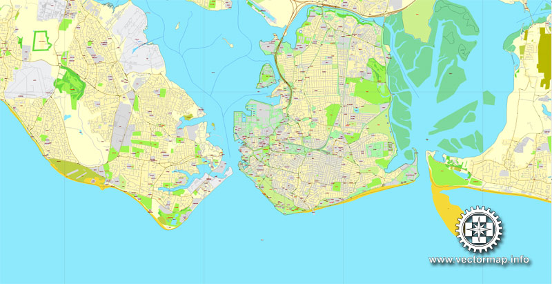
By road, Portsmouth lies 73.5 miles (118.3 km) from Central London, 49.5 miles (79.7 km) west of Brighton, and 22.3 miles (35.9 km) east of Southampton. Portsmouth is situated primarily on Portsea Island and is the United Kingdom’s only island city, although parts of it have expanded onto the mainland. Gosport forms a borough in its own right immediately to the west. The island is separated from the mainland by Portsbridge Creek which is crossed by three road bridges (the M275 motorway, the A3 road, and the A2030 road), a railway bridge, and two footbridges. Portsea Island, which forms part of the Hampshire Basin, is low-lying: the majority of its surface area on the island is less than 3 metres (9.8 ft) above sea level. The highest natural elevation on Portsea Island is the road junction Kingston Cross, at 21 feet (6.4 m).
Old Portsmouth forms the oldest part of the city in the south-west part of Portsea Island, and includes Portsmouth Point, historically nicknamed as Spice Island. The main channel entering Portsmouth Harbour, which lies to the west of Portsea Island, passes between Old Portsmouth and Gosport. Within Portsmouth Harbour are a series of lakes, including Fountain Lake near the harbour, Portchester Lake in the central south, Brick Kiln Lake and Tipner to the east, and Bombketch and Spider Lakes to the west. In the channel further to the northwest, around Portchester, are Wicor, Cams, and Great Cams Lakes. The large tidal inlet of Langstone Harbour lies to the east of Portsea Island. In the northern part, off the coast of Farlington, is the Farlington Marshes, a 125-hectare (308-acre) grazing marsh and saline lagoon. One of the oldest local reserves in the county, built from reclaimed land in 1771, it provides an important habitat for migratory wildfowl and waders.
A high aerial view of Portsea Island (the island which Portsmouth is situated on), and neighbouring Hayling Island.
Portsea Island and Hayling Island
To the south of Portsmouth are the waters of Spithead, the wider Solent, and the Isle of Wight. The southern coast of the city was historically fortified by the Round Tower, the Square Tower, Southsea Castle, Lumps Fort and Fort Cumberland. Four sea forts were built in the Solent to protect Portsmouth by Lord Palmerston, these are named Spitbank Fort, St Helens Fort, Horse Sand Fort and No Mans Land Fort.
The seaside resort of Southsea is situated to the south of Portsea Island, and to the east lies the area known as Eastney. Eastney Lake covered nearly 170 acres (69 hectares) in 1626. To the north of Eastney is the residential district of Milton and an area of reclaimed land now known as Milton Common (formerly Milton Lake), described as a “flat scrubby land with a series of freshwater lakes”. Further north on the east coast is the residential district of Baffins, featuring Great Salterns recreation ground and golf course, which forms an area around Portsmouth College.
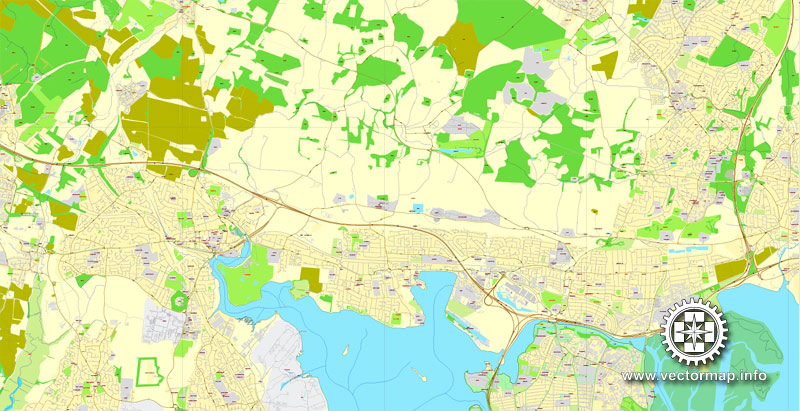
The Hilsea Lines are a series of defunct fortifications on the north coast of the island which border Portsbridge Creek and the mainland. Portsdown Hill dominates the skyline in the northern part of the city, and contains several large Palmerston Forts, such as Fort Fareham, Fort Wallington, Fort Nelson, Fort Southwick, Fort Widley, and Fort Purbrook. Portsdown Hill is formed by a large band of chalk, while the rest of Portsea Island is composed of layers of London Clay and sand (part of the Bagshot Formation), formed principally during the late and early Eocene Epoch.
Northern areas of the city include Stamshaw, Hilsea and Copnor, Cosham, Drayton, Farlington, and Port Solent. Other districts in Portsmouth include North End and Fratton. The west of the city is mainly council estates such as Buckland, Landport, and Portsea. These were built to replace Victorian terraces destroyed by bombing in the Second World War. After the war the 2,000 acres (810 ha) estate of Leigh Park was built to solve the chronic housing shortage during the post-war reconstruction. Since the early 2000s the estate has been entirely under the jurisdiction of Havant Borough Council, but Portsmouth City Council remains the landlord of these properties, making it the biggest landowner in Havant Borough.
The city’s main station, Portsmouth and Southsea railway station, is located in the city centre, close to the Guildhall and the Civic Offices. Just to the south of the Guildhall is Guildhall Walk, a nightlife area with many pubs and clubs. Edinburgh Road contains the city’s Roman Catholic cathedral and Victoria Park, a 15 acres (6.1 ha) park which opened in 1878.
Portsmouth
City in England
Portsmouth is the second largest city in the ceremonial county of Hampshire on the south coast of England. The local authority, Portsmouth City Council was given unitary authority district status in 1997.
Area: 40.25 km²
Ceremonial county: Hampshire
Area code: 023
Colleges and Universities: University of Portsmouth, Highbury College, University of Portsmouth Business School
Portsmouth is the second largest city in the ceremonial county of Hampshire on the south coast of England. The local authority, Portsmouth City Council was given unitary authority district status in 1997. Located mainly on Portsea Island, it is the United Kingdom’s only island city.
Portsmouth is situated 64 miles (103 km) south west of London and 19 miles (31 km) south east of Southampton. The city has a population of 205,400 and is the only city in the United Kingdom with a greater population density than London. The city of Portsmouth and Portsmouth Football Club are both nicknamed “Pompey”.
As a significant naval port for centuries, Portsmouth has the world’s oldest continuously used dry dock and is home to some noted ships, including HMS Warrior, the Tudor carrack Mary Rose and Lord Nelson’s flagship, HMS Victory (the world’s oldest naval ship still in commission). By the 19th century, Portsmouth was one of the most fortified cities in the world. During the Second World War, the city served as a pivotal embarkation point for the D-Day landings and was also chosen as the headquarters for the Supreme Allied Commander, Dwight D. Eisenhower. The city was bombed extensively during what was known as the Portsmouth Blitz, which resulted in the deaths of 930 people. Although smaller than in its heyday, the naval base at HMNB Portsmouth remains the largest dockyard for the Royal Navy and is home to two-thirds of the entire surface fleet.
The waterfront area and Portsmouth Harbour is dominated by the Spinnaker Tower, at 560 feet (170 m). The former HMS Vernon naval shore establishment has since been redeveloped as an area of retail outlets, restaurants, clubs and bars known as Gunwharf Quays. As well as the naval base, Portsmouth International Port is a commercial cruise ship and ferry port which serves international destinations for freight and passenger traffic. Portsmouth forms part of the South Hampshire built-up area which also covers Southampton, Havant, Waterlooville, Eastleigh, Fareham and Gosport. With approximately 860,000 residents, it is the 6th largest urban area in England and the largest in South East England, forming the centre of one of the United Kingdom’s most populous metropolitan areas with a population in excess of one million.
Source Wiki

Free vector map World, Adobe Illustrator, download now maps vector clipart Map for design, projects, presentation free to use as you like. World map vector, Vector world map, World vector map, Map western europe, West europe maps, Map of the world modifiable, High resolution world map, World map illustrator, World map PDF editable, World vector map download,
Free vector map World, Adobe Illustrator, download now maps vector clipart
Map for design, projects, presentation free to use as you like.
Free Download All World Vector Maps here >>>>>
See also: TERMS & CONDITIONS: SOFTWARE LICENSE AGREEMENT FOR DIGITAL CARTOGRAPHIC DATA
Small guide: How to work with the vector map?
You can: Mass select objects by type and color – for example, the objects type “building” (they are usually dark gray) – and remove them from the map, if you do not need them in your print or design project. You can also easily change the thickness of lines (streets), just bulk selection the road by the line color.
The streets are separated by type, for example, type “residential road” are usually white with a gray stroke. Highway usually orange with a brown or dark gray stroke.
All objects are divided by types: different types of roads and streets, polygons of buildings, landfills, urban areas, parks and more other.
It is easy to change the font of inscriptions, all or each individually. Also, just can be make and any other manipulation of objects on the vector map in Adobe illustrator format.
Important: All the proportions on the map are true, that is, the relative sizes of the objects are true, because Map is based on an accurate GPS projection, and It transated into the (usual for all) the Mercator projection.
You can easily change the color, stroke and fill of any object on the map, zoom without loss of quality Image Verification.
Select object

Bulk selection the same objects on the vector map

See the bulk selected objects on the vector map

Bulk delete buildungs from the vector map

Select residencial road (small street) on the vector map

Bulk selection the same lines (streets, roads) on the full map

Create fat lines of the streets on the vector maps (bulk action) 1

Create fat lines of the streets on the vector maps (bulk action) 2

Create fat lines of the streets on the vector maps (bulk action) 3

You can easily change the color, stroke and fill of any object on the map, zoom without loss of quality Image Verification.
More England cities vector maps?

 Author: Kirill Shrayber, Ph.D. FRGS
