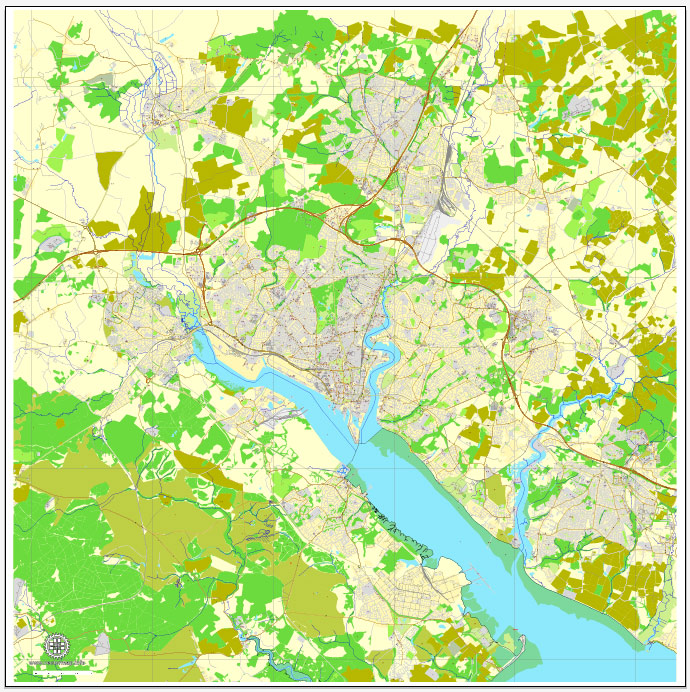
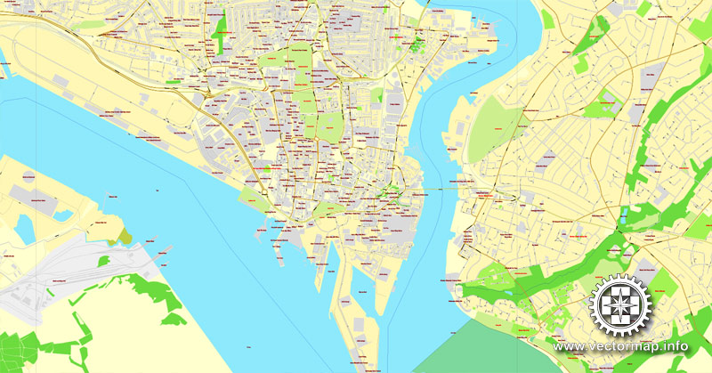
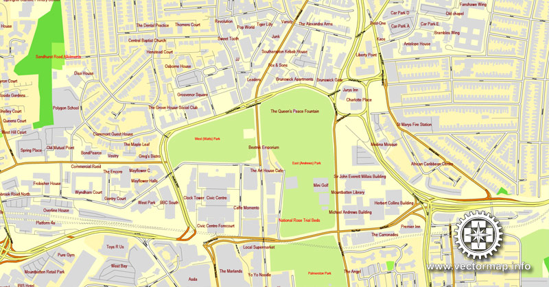
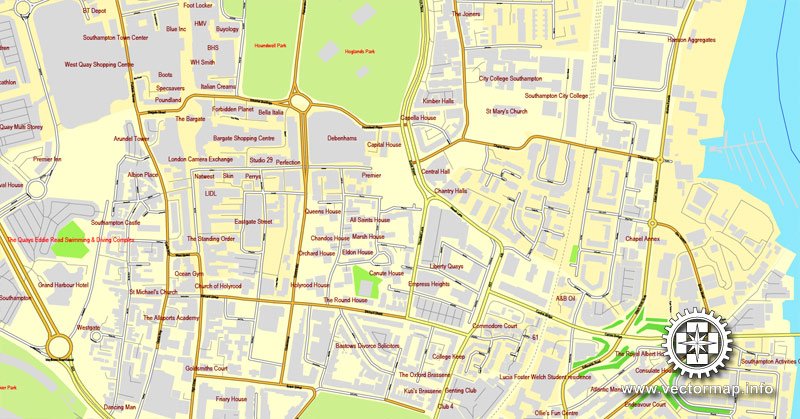
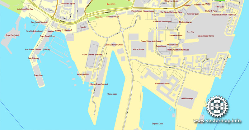
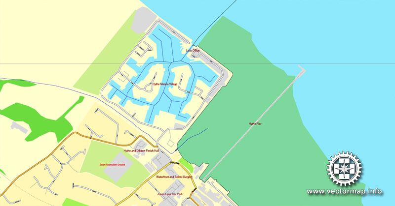
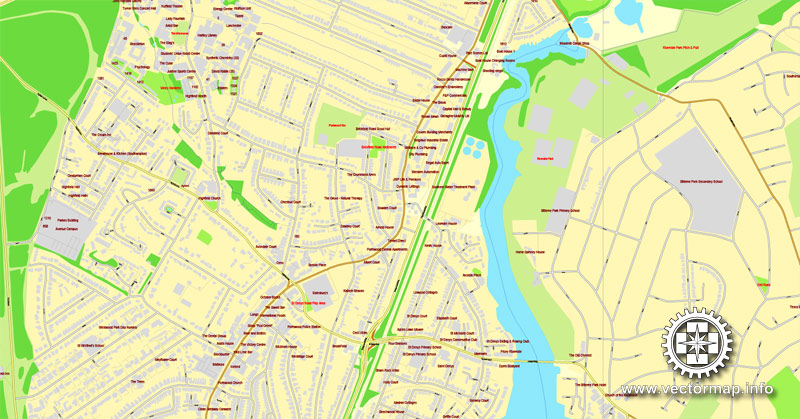
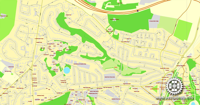
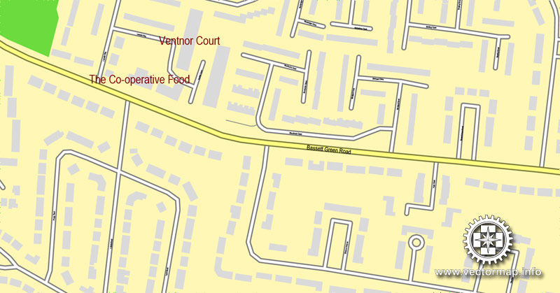
Southampton, Englang, printable vector street map, City Plan V.2, full editable, Adobe Illustrator, Royalty free, full vector, scalable, editable, text format street names, 12,5 mb ZIP
All streets, All buildings.
Map for design, print, arts, projects, presentations, for architects, designers and builders.
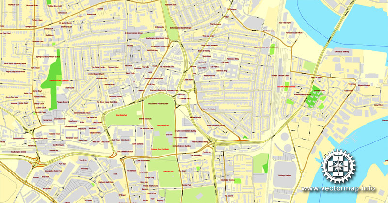
Different font colors of the street names (black); object names by type (brown, red).
The most accurate and detailed map of the city.
DXF, DWG, CDR and other formats – on request, same price, please, contact
Southampton, England.
This vector map of Southampton is used as a basis for design, editing, and further printing.
This is the most detailed, exact map of Southampton for high-quality printing and polygraphy. You can always clarify the map development date by contacting us.
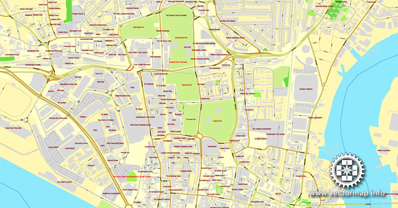
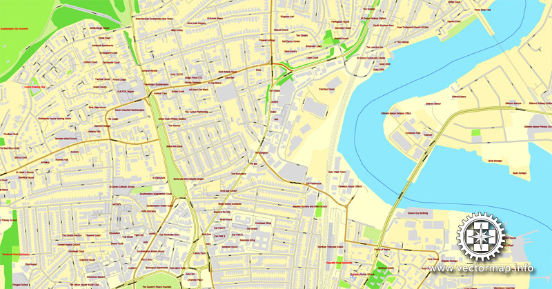
For your convenience, all objects on Southampton vector map are divided into layers. And the editing is very easy – colors, lines, etc.
You can easily add any objects needed (e.g. shops, salons, sale points, gas station or attraction) on any layer of Southampton vector map.
Southampton is the largest city in the ceremonial county of Hampshire, England. It is 69 miles (111 km) south-west of London and 15 miles (24 km) west north-west of Portsmouth. Southampton is a major port and the closest city to the New Forest. It lies at the northernmost point of Southampton Water at the confluence of the Rivers Test and Itchen, with the River Hamble joining to the south of the urban area. The city, which is a unitary authority, has an estimated population of 253,651. The city’s name is sometimes abbreviated in writing to “So’ton” or “Soton”, and a resident of Southampton is called a Sotonian.
One of the advantages of Southampton vector maps of our production is the relevance of cartographic data, we constantly update all our products.
This vector map of Southampton is used by:
designers, layout designers, printers, advertisers and architects. Our product – vector maps – is designed for further editing and printing in large formats – from @Wall format (a few meters) to A-0 and A-1, A-2, A-3.
Southampton map in vector format is used for design, urban planning, presentations and media visualizations.
Advertising and presentation map of Southampton (usually the final designer marks the routes, and puts the client’s objects (shops, saloons, gas stations etc.)
The undoubted advantage is that people will NEVER throw out this advertising product – the map. In fact, as an advertising medium, a map is the most “long-playing” of the well-known polygraphic advertising media, with the longest lifespan, and the maximum number of interactions with the customer.
For travelers, maps are sold at the airports and gas stations around the world. Often the source is our vector maps.
Take a look, who purchases our vector maps of Southampton in “Our Clients and Friends” page – these are large and small companies, from super-brands like Volvo and Starbucks, to small design studios and printing houses.
It’s very easy to work with vector maps of Southampton, even for a not very experienced designer who can turn on and off the map layers, add new objects, change the colors of fill and lines according to customer requirements.
The undoubted advantage of Southampton vector maps in printing is an excellent and detailed visualization, when customer can expand a large paper map and instantly define his location, find a landmark, an object or address on map, unlike using the popular electronic formats of Google and Yandex maps for example.
Printable vector maps of Southampton are much more convenient and efficient than any electronic maps on your smartphone, because ALL DETAILS are displayed in the entire space of Southampton map.
Useful tips on working with vector maps of cities and countries in Adobe Illustrator.
«V» – launches the Selection tool (cursor, black arrow), which makes active any vector line.
«А» – launches the Direct Selection tool (white cursor), allows you to select curve elements and drag them to the desired place.
«R» – activates the Rotate tool, which helps you rotating selected objects around the center point by 360 degrees.
«E» – gives you the opportunity to use the Eraser tool and erase unnecessary parts.
«X» – switches between Fill and Stroke in the Tools section. Try to get used to this hot key and
you will quickly understand that you can’t live and work without it.
Guides are not limited to vertical and horizontal in Adobe Illustrator. You can also create a diagonal guide for example. Moreover, you can turn any contours into guides. Select the outline and go to View > Guides > Make Guides (Create Guides), or simply press Cmd/Ctrl + 5. You can also turn the guides back into an editable object. Go to menu, View > Guides > Unlock Guides (Release Guides), select the guide you want to edit and select View > Guides > Release Guides (Reset Guides), or just press Cmd/Ctrl + Option / Alt + 5).
You will probably want to change the color scheme used on our Southampton vector map.
To quickly and effectively play with colors.
Of course, you can do it manually, all objects in our Southampton vector map are divided according to types and layers, and you can easily change the color gamma of vector objects in groups and layers.
But there is more effective way of working with the whole VECTOR MAP of Southampton and all layers:
The overview dialog «Edit colors»/«Repaint Graphic Object» (this dialog box name can change depending on the context):
If you have selected a part or a layer of Southampton vector map and open the dialog box by clicking the icon in the Control panel, on the Samples palette or the Color Catalog, or if you choose Edit > Edit Colors> Repaint Graphic Object, then the «Repaint Graphic Object» dialog box appears, and you get access to «Assign» and «Edit» tabs.
If a picture or a map fragment is not selected, and you open the dialog box by clicking the icon in the Control panel, on the Samples palette or in the Color Catalog, the «Edit Colors» dialog box appears and you can only access the «Edit» tab.
Regardless of the name at the top of the dialog box, the right-hand side always displays the color group of the current document, as well as two default color groups: Print Color and Grayscale. These color groups can be selected and used any time.
Create and edit color groups of Southampton vector map, and also assign colors using the «Edit Colors»/ а «Repaint Graphic Object» dialog box.
A. Creating and editing of a color group on the «Edit» tab
B. Assigning colors on the «Assign» tab
C. Select a group of colors from the «Color groups» list
The option «Repaint a graphic object» in the lower part of the dialog box allows you to preview the colors on a selected layer of Vector map, or a group of elements, and specify whether its colors will be redefined when the dialog box is closed.
The main areas of the dialog box are:
«Edit»
The «Edit» tab is designed to create a new or edit the existing color groups.
The harmony rules Menu and the Color Wheel are used to conduct experiments with color harmonies. The color wheel shows how colors are related in color harmony, and the color bars allow you to view and manipulate an individual color values. In addition, you can adjust the brightness, add and remove colors, save color groups and view colors on the selected Vector Map of Southampton or a separated layers.
«Assign»
The «Assign» tab is used to view and control on how the original colors are replaced with colors from the color group like your corporate colors in the Vector Map of Southampton.
The assign color ability is provided only if the entire map, layer or fragment is selected in the document. You can specify which of new colors replace the current colors, whether the spot colors should be preserved and how colors are replaced (for example, you can replace colors completely or changing the color tone while maintaining the brightness). The «Assign» tab allows you to redefine colors in the Vector Map of Southampton, or in separate layers and fragments using the current color group or reducing the number of colors in the current Vector Map.
Color groups
Is a list of all saved color groups for current document (the same groups appear in the «Samples» palette). You can edit and delete the existing color groups, as well as creating a new ones using the list of “Color Groups” in the dialog box. All changes appear in the «Samples» palette.
The highlighted color group shows, which color group is currently edited.
Any color group can be selected and edited, or used to redefine the colors in the selected vector map of Southampton, its fragments or elements.
Saving a color group adds this group to the specified list.
Opening the «Edit Colors»/«Repaint Graphic Object» dialog box.
Open the «Edit Colors»/«Repaint Graphic Object» dialog box using one of the following methods:
«Edit»> «Edit Colors»> «Repaint Graphic object» or «Repaint With Style».
Use these commands if you need to edit the colors in the selected vector map of Southampton.
«Repaint Graphic object» button on the «Control» panel.
Use this button if you need to adjust colors of Southampton vector map using the а «Repaint graphic object» dialog box.
The specified button is available if the selected vector map or its fragment contains two or more colors.
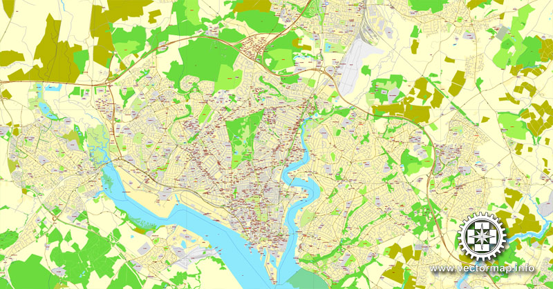
Significant employers in the city include Southampton City Council, the University of Southampton, Solent University, Southampton Airport, Ordnance Survey, BBC South, the NHS, ABP and Carnival UK. Southampton is noted for its association with the RMS Titanic, the Spitfire and more generally in the World War II narrative as one of the departure points for D-Day, and more recently as the home port of a number of the largest cruise ships in the world. Southampton has a large shopping centre and retail park, Westquay. In 2014, the city council approved a neighbouring followup Westquay South which opened in 2016–2017.
Note. This color editing method is convenient for global color adjustment in a vector map, if global colors were not used when creating a Map of Southampton.
The «Edit colors» button or «Edit or apply colors» on the «Color Catalog» palette
Click this button if you need to edit colors on the «Color Catalog» palette or edit and then apply them to the selected Vector Map of Southampton or its fragment.
The «Edit color group» button or «Edit or apply color group» on the «Samples» palette.
Click this button if you need to edit the colors in the specific color group or edit and apply them to the selected Vector Map of Southampton or a group of its elements, for example, the whole layer “Streets and lines”. You can also double-click the color group in the Samples panel to open the dialog box.
If the map file is too large and your computer freezes or even can’t open it quickly:
1. Try to reduce the color resolution of the video card (display) to 256 colors while working with a large map.
2. Using Windows Task Manager, select all the application you don’t need, while working with map, just turn them off.
3. Launch Adobe Illustrator. (DO NOT OPEN the vector map file)
4. Start the Windows Task Manager using administrator rights > Find the “Illustrator” process > set the «real time» priority,
5. Open the file. When you see the LEGACY FONT popup window – click “OK” (do not update). You can restore the TEXT later.
6. Can also be useful: When file is opened – Edit > Settings > Basic Settings > disable smoothing. /// It looks scary, but works quickly)))
We recommend saving the file in Adobe Illustrator 10 version. It’s much more stable when working with VERY BIG size files.
In the 2001 census Southampton and Portsmouth were recorded as being parts of separate urban areas; however by the time of the 2011 census they had merged apolitically to become the sixth-largest built-up area in England with a population of 855,569. This built-up area is part of the metropolitan area known as South Hampshire, which is also known as Solent City, particularly in the media when discussing local governance organisational changes. With a population of over 1.5 million this makes the region one of the United Kingdom’s most populous metropolitan areas.
Geography
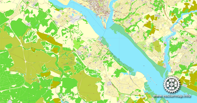
The geography of Southampton is influenced by the sea and rivers. The city lies at the northern tip of the Southampton Water, a deep water estuary, which is a ria formed at the end of the last Ice Age. Here, the rivers Test and Itchen converge. The Test—which has salt marsh that makes it ideal for salmon fishing—runs along the western edge of the city, while the Itchen splits Southampton in two—east and west. The city centre is located between the two rivers.
Town Quay is the original public quay, and dates from the 13th century. Today’s Eastern Docks were created in the 1830s by land reclamation of the mud flats between the Itchen & Test estuaries. The Western Docks date from the 1930s when the Southern Railway Company commissioned a major land reclamation and dredging programme. Most of the material used for reclamation came from dredging of Southampton Water, to ensure that the port can continue to handle large ships.
Southampton Water has the benefit of a double high tide, with two high tide peaks, making the movement of large ships easier. This is not caused as popularly supposed by the presence of the Isle of Wight, but is a function of the shape and depth of the English Channel. In this area the general water flow is distorted by more local conditions reaching across to France.
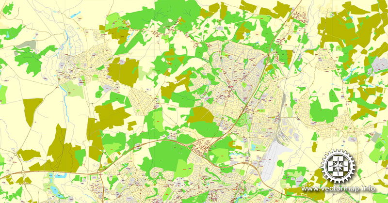
The city lies in the Hampshire Basin, which sits atop chalk beds.
The River Test runs along the western border of the city, separating it from the New Forest. There are bridges over the Test from Southampton, including the road and rail bridges at Redbridge in the south and the M27 motorway to the north. The River Itchen runs through the middle of the city and is bridged in several places. The northernmost bridge, and the first to be built, is at Mansbridge, where the A27 road crosses the Itchen. The original bridge is closed to road traffic, but is still standing and open to pedestrians and cyclists. The river is bridged again at Swaythling, where Woodmill Bridge separates the tidal and non tidal sections of the river. Further south is Cobden Bridge which is notable as it was opened as a free bridge (it was originally named the Cobden Free Bridge), and was never a toll bridge. Downstream of the Cobden Bridge is the Northam Railway Bridge, then the Northam Road Bridge, which was the first major pre-stressed concrete bridge to be constructed in the United Kingdom. The southernmost, and newest, bridge on the Itchen is the Itchen Bridge, which is a toll bridge.
Southampton
City in England
Southampton is the largest city in the ceremonial county of Hampshire on the south coast of England, and is situated 75 miles south-west of London and 19 miles north-west of Portsmouth.
Area: 51.81 km²
Ceremonial county: Hampshire
Area code: 023
Southampton is the largest city in the ceremonial county of Hampshire on the south coast of England, and is situated 75 miles (121 km) south-west of London and 19 miles (31 km) north-west of Portsmouth. Southampton is a major port and the closest city to the New Forest. It lies at the northernmost point of Southampton Water at the confluence of the River Test and River Itchen, with the River Hamble joining to the south of the urban area. The city, which is a unitary authority, has an estimated population of 253,651. The city’s name is sometimes abbreviated in writing to “So’ton” or “Soton”, and a resident of Southampton is called a Sotonian.
Significant employers in the city of Southampton include The University of Southampton, Southampton Solent University, Southampton Airport, Ordnance Survey, BBC South, the NHS, ABP and Carnival UK. Southampton is noted for its association with the RMS Titanic, the Spitfire and more generally in the World War II narrative as one of the departure points for D-Day, and more recently as the home port of a number of the largest cruise ships in the world. Southampton has a large shopping centre and retail park called WestQuay. In October 2014, the City Council approved a follow-up from the WestQuay park, called WestQuay Watermark. Construction by Sir Robert McAlpine commenced in January 2015. Hammerson, the owners of the retail park, aim to have at least 1,550 people employed on its premises at year-end 2016.
In the 2011 census Southampton and Portsmouth were recorded as being parts of separate urban areas, however by the time of the 2011 census they had merged to become the sixth largest built-up area in England with a population of 855,569. This built-up area is part of the metropolitan area known as South Hampshire, which is also known as Solent City, particularly in the media when discussing local governance organisational changes. With a population of over 1.5 million this makes the region one of the United Kingdom‘s most populous metropolitan areas.
Source

Free vector map World, Adobe Illustrator, download now maps vector clipart Map for design, projects, presentation free to use as you like. World map vector, Vector world map, World vector map, Map western europe, West europe maps, Map of the world modifiable, High resolution world map, World map illustrator, World map PDF editable, World vector map download,
Free vector map World, Adobe Illustrator, download now maps vector clipart
Map for design, projects, presentation free to use as you like.
Free Download All World Vector Maps here >>>>>
See also: TERMS & CONDITIONS: SOFTWARE LICENSE AGREEMENT FOR DIGITAL CARTOGRAPHIC DATA
Small guide: How to work with the vector map?
You can: Mass select objects by type and color – for example, the objects type “building” (they are usually dark gray) – and remove them from the map, if you do not need them in your print or design project. You can also easily change the thickness of lines (streets), just bulk selection the road by the line color.
The streets are separated by type, for example, type “residential road” are usually white with a gray stroke. Highway usually orange with a brown or dark gray stroke.
All objects are divided by types: different types of roads and streets, polygons of buildings, landfills, urban areas, parks and more other.
It is easy to change the font of inscriptions, all or each individually. Also, just can be make and any other manipulation of objects on the vector map in Adobe illustrator format.
Important: All the proportions on the map are true, that is, the relative sizes of the objects are true, because Map is based on an accurate GPS projection, and It transated into the (usual for all) the Mercator projection.
You can easily change the color, stroke and fill of any object on the map, zoom without loss of quality Image Verification.
Select object

Bulk selection the same objects on the vector map

See the bulk selected objects on the vector map

Bulk delete buildungs from the vector map

Select residencial road (small street) on the vector map

Bulk selection the same lines (streets, roads) on the full map

Create fat lines of the streets on the vector maps (bulk action) 1

Create fat lines of the streets on the vector maps (bulk action) 2

Create fat lines of the streets on the vector maps (bulk action) 3

You can easily change the color, stroke and fill of any object on the map, zoom without loss of quality Image Verification.

 Author: Kirill Shrayber, Ph.D. FRGS
