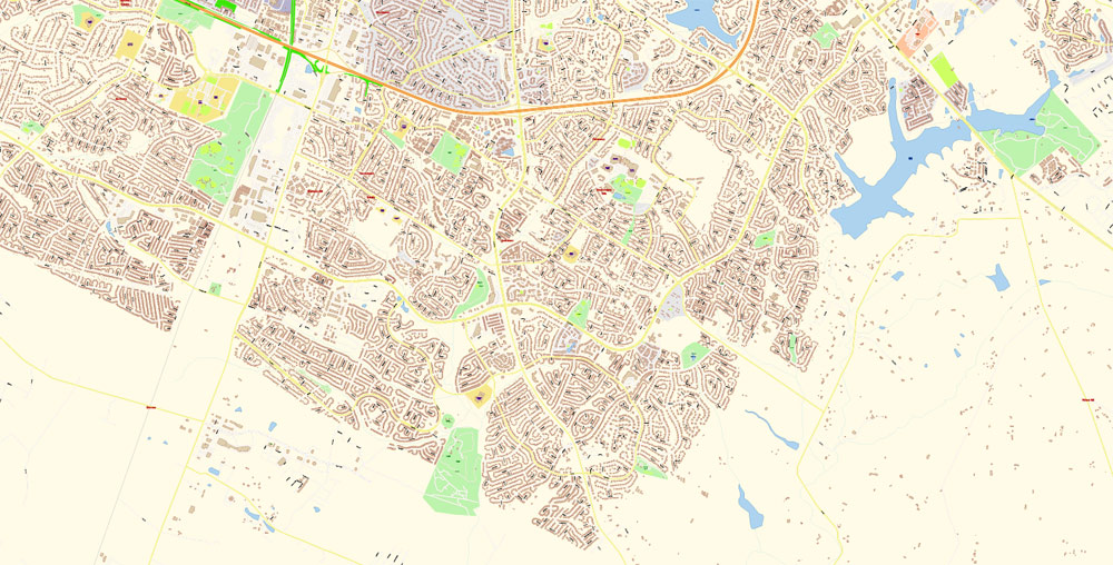
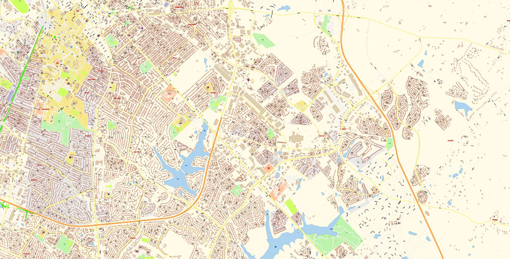
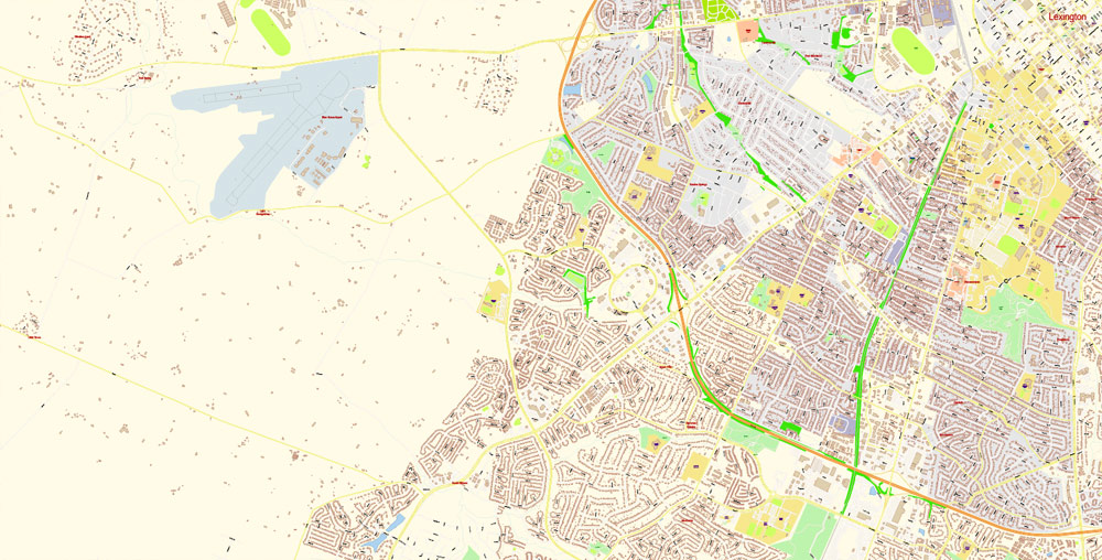
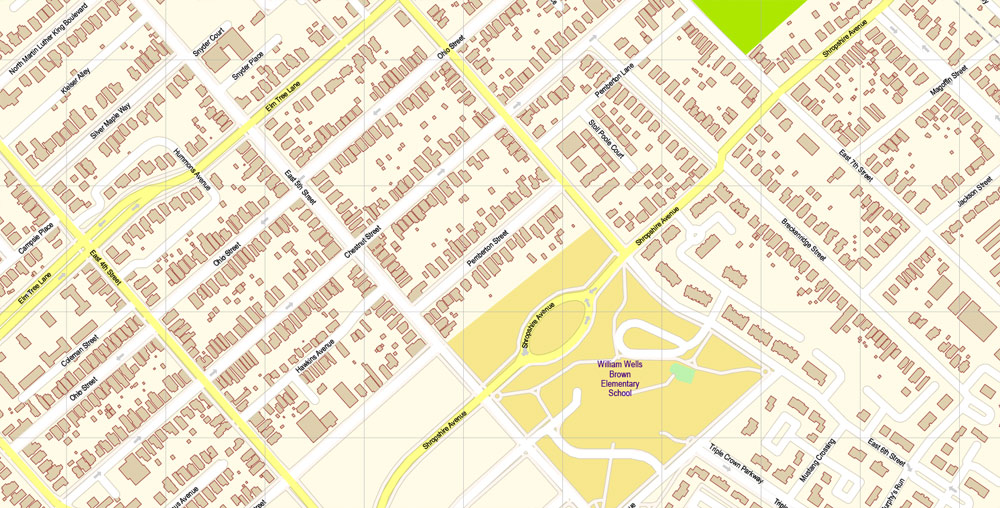
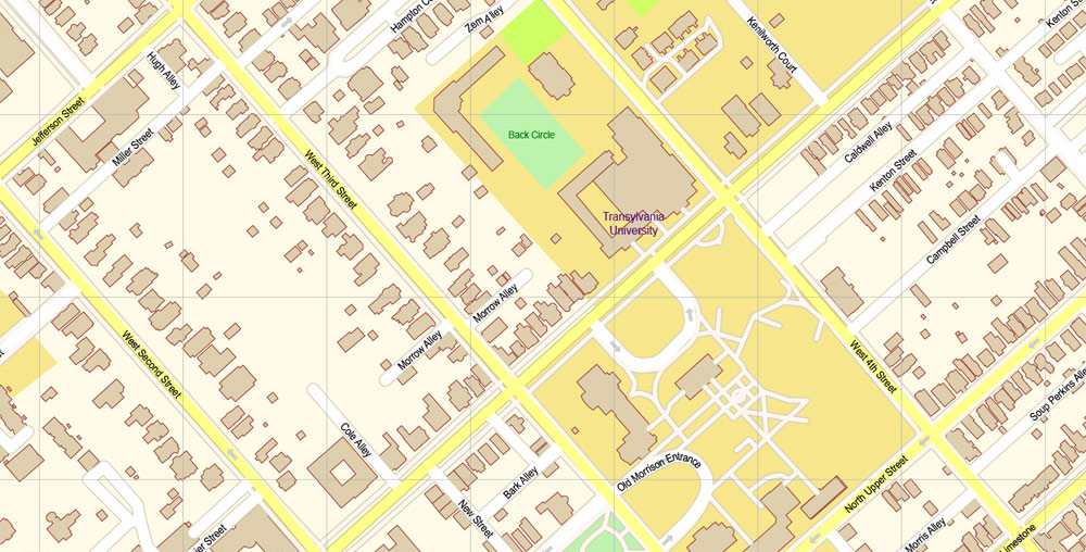
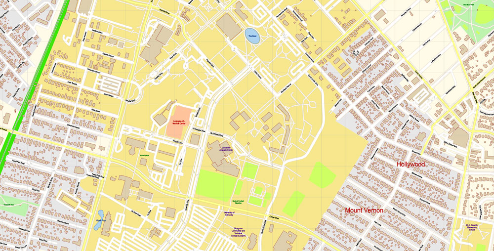
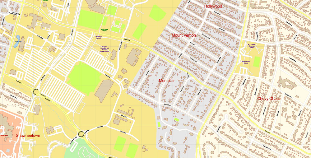
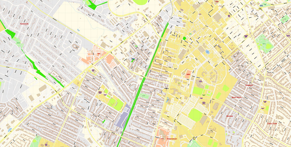
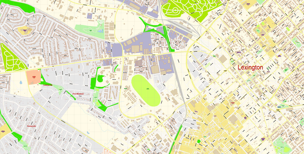
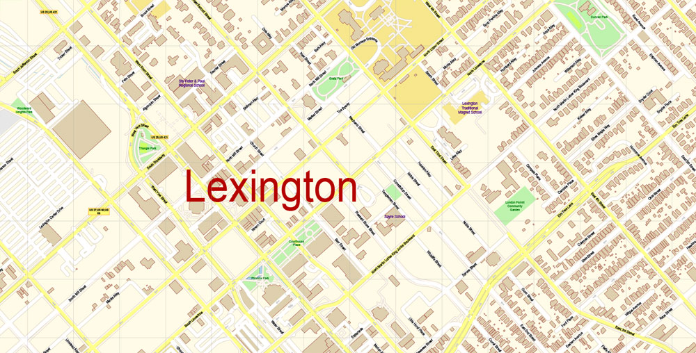
Printable PDF Vector Map of Lexington Kentucky US detailed City Plan scale 1:3699 full editable Adobe PDF Street Map in layers , scalable, editable text format all names, 37 mb ZIP
All streets names, Main Objects, All Buildings. Map for design, printing, arts, projects, presentations, for architects, designers and builders, business, logistics.
Layers: color_fills, streets_roads, labels_roads, names_objects, names_streets, names_places, water, buildings, grids, legend, etc.
The most exact and detailed map of the city in scale.
For Editing and High Quality Printing
DWG, DXF and other formats – on request, same price, please, contact
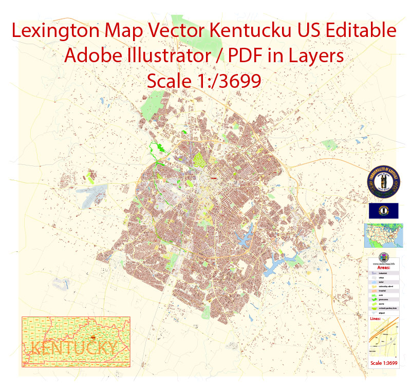
Lexington, consolidated with Fayette County and often denoted as Lexington-Fayette, is the second-largest city in Kentucky and the 60th-largest city in the United States. By land area, Lexington is the 28th largest city in the United States.
For your convenience, all objects on Lexington vector city map are divided into layers. And the editing is very easy – colors, lines, etc.
Known as the “Horse Capital of the World,” it is the heart of the state’s Bluegrass region. With a mayor-alderman form of government, it is one of two cities in Kentucky designated by the state as first-class; the other is the state’s largest city of Louisville.
One of the advantages of Lexington city vector maps of our production is the relevance of cartographic data, we constantly update all our products.
The advertising and presentation map of Lexington city (usually the final designer marks the routes, and puts the client’s objects (shops, saloons, gas stations etc.)
The undoubted advantage is that people will NEVER throw out this advertising product – the map. In fact, as an advertising medium, a city map is the most “long-playing” of the well-known polygraphic advertising media, with the longest lifespan, and the maximum number of interactions with the customer.
In the 2017 U.S. Census Estimate, the city’s population was 321,959, anchoring a metropolitan area of 512,650 people and a combined statistical area of 856,849 people.
Create and edit color groups of Lexington city vector map, and also assign colors using the «Edit Colors»/ а «Repaint Graphic Object» dialog box.
A. Creating and editing of a color group on the «Edit» tab
B. Assigning colors on the «Assign» tab
C. Select a group of colors from the «Color groups» list
The option «Repaint a graphic object» in the lower part of the dialog box allows you to preview the colors on a selected layer of Vector map, or a group of elements, and specify whether its colors will be redefined when the dialog box is closed.
The main areas of the dialog box are:
«Edit»
The «Edit» tab is designed to create a new or edit the existing color groups.
The harmony rules Menu and the Color Wheel are used to conduct experiments with color harmonies. The color wheel shows how colors are related in color harmony, and the color bars allow you to view and manipulate an individual color values. In addition, you can adjust the brightness, add and remove colors, save color groups and view colors on the selected Vector Map of Lexington city or a separated layers.
Assign
The «Assign» tab is used to view and control on how the original colors are replaced with colors from the color group like your corporate colors in the Vector Map of Lexington city.
Lexington ranks 10th among US cities in college education rate, with 39.5% of residents having at least a bachelor’s degree. Printable vector maps of Lexington city are much more convenient and efficient than any electronic maps on your smartphone, because ALL DETAILS are displayed in the entire space of Lexington city map. Any color group can be selected and edited, or used to redefine the colors in the selected vector map of Lexington city, its fragments or elements.
Saving a color group adds this group to the specified list.
Opening the «Edit Colors»/«Repaint Graphic Object» dialog box.
Open the «Edit Colors»/«Repaint Graphic Object» dialog box using one of the following methods:
«Edit»> «Edit Colors»> «Repaint Graphic object» or «Repaint With Style».
Use these commands if you need to edit the colors in the selected vector map of Lexington city.
Useful tips on working with vector maps of cities and countries in Adobe Illustrator.
«V» – launches the Selection tool (cursor, black arrow), which makes active any vector line.
«А» – launches the Direct Selection tool (white cursor), allows you to select curve elements and drag them to the desired place.
«R» – activates the Rotate tool, which helps you rotating selected objects around the center point by 360 degrees.
«E» – gives you the opportunity to use the Eraser tool and erase unnecessary parts.
«X» – switches between Fill and Stroke in the Tools section. Try to get used to this hot key and
you will quickly understand that you can’t live and work without it.
Guides are not limited to vertical and horizontal in Adobe Illustrator. You can also create a diagonal guide for example. Moreover, you can turn any contours into guides. Select the outline and go to View > Guides > Make Guides (Create Guides), or simply press Cmd/Ctrl + 5. You can also turn the guides back into an editable object. Go to menu, View > Guides > Unlock Guides (Release Guides), select the guide you want to edit and select View > Guides > Release Guides (Reset Guides), or just press Cmd/Ctrl + Option / Alt + 5).
It is the location of the Kentucky Horse Park, The Red Mile, and Keeneland race courses, Rupp Arena, Transylvania University, the University of Kentucky, and Bluegrass Community and Technical College.
Geography
Lexington, which includes all Fayette County, consists of 285.5 square miles (739.4 km2), mostly gently rolling plateau, in the center of the inner Bluegrass region. The area is noted for its fertile soil, excellent pastureland, and horse and stock farms. Poa pratensis (bluegrass) thrives on the limestone beneath the soil’s surface, playing a major role in the development of champion horses; it is associated with the area’s beauty of landscape. Numerous small creeks rise and flow into the Kentucky River.
The Lexington-Fayette metro area includes five additional counties: Clark, Jessamine, Bourbon, Woodford, and Scott. This is the second-largest metro area in Kentucky after Louisville. According to the United States Census Bureau, the city has a total area of 285.5 square miles (739 km2). 284.5 square miles (737 km2) of it is land and 1.0 square mile (2.6 km2) of it (0.35%) is covered by water.
Cityscape
Main article: Cityscape of Lexington, Kentucky
Lexington features a diverse cityscape. Forbes has ranked Lexington 10th place in the world’s cleanest cities.
Planning
Lexington must manage a rapidly growing population while working to maintain the character of the surrounding horse farms that give the region its identity. In 1958, Lexington enacted the nation’s first urban growth boundary, restricting new development to an urban service area (USA). It set a strict minimum area requirement, currently 40 acres (160,000 m2), to maintain open space for landholdings in the rural service area. In 1967, the USA was decreased in area; various zoning regulations were also amended from the original 1958 issue.
In 1980, the comprehensive plan was updated: the USA was modified to include urban activity centers (UACs) and rural activity centers (RACs). The UACs were commercial and light-industrial districts in urbanized areas, while RACs were retail trade and light-industrial centers clustered around the Interstate 64/Interstate 75 interchanges.
This vector map of Lexington city is used as a basis for design, editing, and further printing.
This is the most detailed, exact map of Lexington city for high-quality printing and polygraphy. You can always clarify the map development date by contacting us.
If a picture or a map fragment is not selected, and you open the dialog box by clicking the icon in the Control panel, on the Samples palette or in the Color Catalog, the «Edit Colors» dialog box appears and you can only access the «Edit» tab.
Regardless of the name at the top of the dialog box, the right-hand side always displays the color group of the current document, as well as two default color groups: Print Color and Grayscale. These color groups can be selected and used any time.
In 1996, the USA was expanded when 5,300 acres (21 km2) of the RSA were acquired through the expansion area master plan (EAMP).
It’s very easy to work with vector maps of Lexington city, even for a not very experienced designer who can turn on and off the map layers, add new objects, change the colors of fill and lines according to customer requirements.
The undoubted advantage of Lexington city vector maps in printing is an excellent and detailed visualization, when customer can expand a large paper map and instantly define his location, find a landmark, an object or address on map, unlike using the popular electronic formats of Google and Yandex maps for example. But there is more effective way of working with the whole VECTOR MAP of Lexington city and all layers:
The overview dialog «Edit colors»/«Repaint Graphic Object» (this dialog box name can change depending on the context):
If you have selected a part or a layer of Lexington city vector map and open the dialog box by clicking the icon in the Control panel, on the Samples palette or the Color Catalog, or if you choose Edit > Edit Colors> Repaint Graphic Object, then the «Repaint Graphic Object» dialog box appears, and you get access to «Assign» and «Edit» tabs.
This was controversial: this first major update to the comprehensive plan in over a decade was accompanied by arguments among residents about the future of Lexington and the Thoroughbred farms.
The EAMP included new concepts of impact fees, assessment districts, neighborhood design concepts, design overlays, mandatory greenways, major roadway improvements, stormwater management, and open-space mitigation for the first time.
«Repaint Graphic object» button on the «Control» panel.
Use this button if you need to adjust colors of Lexington city vector map using the а «Repaint graphic object» dialog box.
The specified button is available if the selected vector map or its fragment contains two or more colors.
Note. This color editing method is convenient for global color adjustment in a vector map, if global colors were not used when creating a City Map of Lexington.
The assign color ability is provided only if the entire map, layer or fragment is selected in the document. You can specify which of new colors replace the current colors, whether the spot colors should be preserved and how colors are replaced (for example, you can replace colors completely or changing the color tone while maintaining the brightness). The «Assign» tab allows you to redefine colors in the Vector Map of Lexington city, or in separate layers and fragments using the current color group or reducing the number of colors in the current Vector Map.
Color groups
Is a list of all saved color groups for current document (the same groups appear in the «Samples» palette). You can edit and delete the existing color groups, as well as creating a new ones using the list of “Color Groups” in the dialog box. All changes appear in the «Samples» palette.
The highlighted color group shows, which color group is currently edited.
You can easily add any objects needed (e.g. shops, salons, sale points, gas station or attraction) on any layer of Lexington vector map.
It also included a draft of the rural land management plan, which included large-lot zoning and traffic-impact controls. A prezoning of the entire expansion area was refuted in the plan. A 50-acre (200,000 m2) minimum proposal was defeated. Discussion of this proposal appeared to stimulate the development of numerous 10-acre (40,000 m2) subdivisions in the RSAs.
You will probably want to change the color scheme used on our Lexington vector city map.
To quickly and effectively play with colors.
Of course, you can do it manually, all objects in our Lexington city vector map are divided according to types and layers, and you can easily change the color gamma of vector objects in groups and layers.
For travelers, maps are sold at the airports and gas stations around the world. Often the source is our vector maps.
This vector map of Lexington city is used by:
designers, layout designers, printers, advertisers and architects. Our product – vector maps – is designed for further editing and printing in large formats – from @Wall format (a few meters) to A-0 and A-1, A-2, A-3.
Three years after the expansion was initiated, the RSA land management plan was adopted, which increased the minimum lot size in the agricultural rural zones to 40-acre (160,000 m2) minima. Take a look, who purchases our vector maps of Lexington city in “Our Clients and Friends” page – these are large and small companies, from super-brands like Volvo and Starbucks, to small design studios and printing houses.
In 2000, a purchase of development rights plan was adopted, granting the city the power to purchase the development rights of existing farms; in 2001, $40 million were allocated to the plan from a $25-million local, $15-million state grant.
The Lexington city map in vector format is used for design, urban planning, presentations and media visualizations.
An infill and redevelopment study was also initiated during that time, along with design guidelines for the areas surrounding the new Fayette County courthouses.
The «Edit colors» button or «Edit or apply colors» on the «Color Catalog» palette
Click this button if you need to edit colors on the «Color Catalog» palette or edit and then apply them to the selected Vector Map of Lexington city or its fragment.
The «Edit color group» button or «Edit or apply color group» on the «Samples» palette.
Click this button if you need to edit the colors in the specific color group or edit and apply them to the selected Vector Map of Lexington city or a group of its elements, for example, the whole layer “Streets and lines”. You can also double-click the color group in the Samples panel to open the dialog box.
If the map file is too large and your computer freezes or even can’t open it quickly:
1. Try to reduce the color resolution of the video card (display) to 256 colors while working with a large map.
2. Using Windows Task Manager, select all the application you don’t need, while working with map, just turn them off.
3. Launch Adobe Illustrator. (DO NOT OPEN the vector map file)
4. Start the Windows Task Manager using administrator rights > Find the “Illustrator” process > set the «real time» priority,
5. Open the file. When you see the LEGACY FONT popup window – click “OK” (do not update). You can restore the TEXT later.
6. Can also be useful: When file is opened – Edit > Settings > Basic Settings > disable smoothing. /// It looks scary, but works quickly)))
We recommend saving the file in Adobe Illustrator 10 version. It’s much more stable when working with VERY BIG size files.
Lexington
City in Kentucky
Lexington is a city in Kentucky. It’s known for horse farms and thoroughbred racetracks like Keeneland. The Kentucky Horse Park features the International Museum of the Horse, the Hall of Champions and many equine breeds. Ashland, the estate of 1800s politician Henry Clay, includes a mansion and formal garden. Clay is buried at the Lexington Cemetery, which has an arboretum, lakes and a Romanesque gatehouse.
Area
• Consolidated city-county 285.5 sq mi (739.4 km2)
• Land 284.5 sq mi (736.9 km2)
• Water 1.0 sq mi (2.6 km2)
• Urban 87.5 sq mi (226.7 km2)
Elevation 978 ft (298 m)
Population
• Consolidated city-county 318,449[1]
• Rank US: 60th Kentucky: 2nd
• Density 1,042.8/sq mi (364.5/km2)
• Urban 318,449
• Metro 606,751
Free US vector maps

Free Download Vector Map US County and State Adobe Illustrator
Free_Vector_Map_US_States_County_Map.ai
Free Download Vector Map US County and State Adobe PDF
Free_Vector_Map_US_States_County_Map.pdf

Free Download Vector Map US With States Names, Adobe Illustrator
Free_Map_of_USA_with_state_names_en.ai
Free Download Vector Map US With States Names, Adobe PDF
Free_Map_of_USA_with_state_names_en.pdf
From WIKI
Free vector map World, Adobe Illustrator, download now maps vector clipart
Map for design, projects, presentation free to use as you like.
See also: TERMS & CONDITIONS: SOFTWARE LICENSE AGREEMENT FOR DIGITAL CARTOGRAPHIC DATA.
Need more USA Vector Maps, printable and editable?


 Author: Kirill Shrayber, Ph.D. FRGS
 + Admin Areas editable Adobe Illustrator in layers")
 + Admin Areas + Relief Shaded Raster, editable Adobe Illustrator in layers")