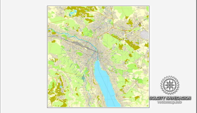
Zurich, Switzerland, printable vector street full City Plan map, full editable, Adobe Illustrator, full vector, scalable, editable, text format street names, 7,1 mb ZIP
All streets, all buildings.
Map for design, print, arts, projects.
CDR, DWG, DXF and other formats – on demand, same price, please, contact
Zürich, Schweiz druckbare Vektor Straßenkarte voll Stadtplan, voll editierbar, Adobe Illustrator, voll Vektor, skalierbare, editierbare Textformat Straßennamen , 7,1 MB ZIP
Alle Straßen, alle Gebäude.
Karte für Design, Druck, Kunst, Projekte.
Zurich, Switzerland.
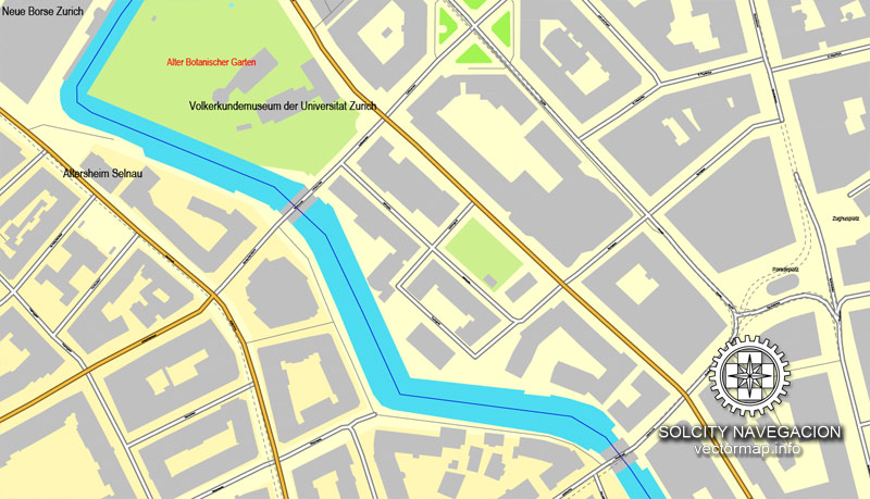
This vector map of Zurich city is used as a basis for design, editing, and further printing.
This is the most detailed, exact map of Zurich city for high-quality printing and polygraphy. You can always clarify the map development date by contacting us.
For your convenience, all objects on Zurich vector city map are divided into layers. And the editing is very easy – colors, lines, etc.
You can easily add any objects needed (e.g. shops, salons, sale points, gas station or attraction) on any layer of Zurich vector map.
Zürich or Zurich is the largest city in Switzerland and the capital of the canton of Zürich. It is located in north-central Switzerland at the northwestern tip of Lake Zürich. The municipality has approximately 400,028 inhabitants, the urban agglomeration 1.315 million and the Zürich metropolitan area 1.83 million. Zürich is a hub for railways, roads, and air traffic. Both Zürich Airport and railway station are the largest and busiest in the country.
One of the advantages of Zurich city vector maps of our production is the relevance of cartographic data, we constantly update all our products.
This vector map of Zurich city is used by:
designers, layout designers, printers, advertisers and architects. Our product – vector maps – is designed for further editing and printing in large formats – from @Wall format (a few meters) to A-0 and A-1, A-2, A-3.
The Zurich city map in vector format is used for design, urban planning, presentations and media visualizations.
The advertising and presentation map of Zurich city (usually the final designer marks the routes, and puts the client’s objects (shops, saloons, gas stations etc.)
The undoubted advantage is that people will NEVER throw out this advertising product – the map. In fact, as an advertising medium, a city map is the most “long-playing” of the well-known polygraphic advertising media, with the longest lifespan, and the maximum number of interactions with the customer.
Permanently settled for over 2,000 years, Zürich was founded by the Romans, who, in 15 BC, called it Turicum. However, early settlements have been found dating back more than 6,400 years ago. During the Middle Ages, Zürich gained the independent and privileged status of imperial immediacy and, in 1519, became a primary centre of the Protestant Reformation in Europe under the leadership of Huldrych Zwingli.
For travelers, maps are sold at the airports and gas stations around the world. Often the source is our vector maps.
Take a look, who purchases our vector maps of Zurich city in “Our Clients and Friends” page – these are large and small companies, from super-brands like Volvo and Starbucks, to small design studios and printing houses.
It’s very easy to work with vector maps of Zurich city, even for a not very experienced designer who can turn on and off the map layers, add new objects, change the colors of fill and lines according to customer requirements.
The undoubted advantage of Zurich city vector maps in printing is an excellent and detailed visualization, when customer can expand a large paper map and instantly define his location, find a landmark, an object or address on map, unlike using the popular electronic formats of Google and Yandex maps for example.
Printable vector maps of Zurich city are much more convenient and efficient than any electronic maps on your smartphone, because ALL DETAILS are displayed in the entire space of Zurich city map.
Useful tips on working with vector maps of cities and countries in Adobe Illustrator.
«V» – launches the Selection tool (cursor, black arrow), which makes active any vector line.
«А» – launches the Direct Selection tool (white cursor), allows you to select curve elements and drag them to the desired place.
«R» – activates the Rotate tool, which helps you rotating selected objects around the center point by 360 degrees.
«E» – gives you the opportunity to use the Eraser tool and erase unnecessary parts.
«X» – switches between Fill and Stroke in the Tools section. Try to get used to this hot key and
you will quickly understand that you can’t live and work without it.
Guides are not limited to vertical and horizontal in Adobe Illustrator. You can also create a diagonal guide for example. Moreover, you can turn any contours into guides. Select the outline and go to View > Guides > Make Guides (Create Guides), or simply press Cmd/Ctrl + 5. You can also turn the guides back into an editable object. Go to menu, View > Guides > Unlock Guides (Release Guides), select the guide you want to edit and select View > Guides > Release Guides (Reset Guides), or just press Cmd/Ctrl + Option / Alt + 5).
You will probably want to change the color scheme used on our Zurich vector city map.
To quickly and effectively play with colors.
Of course, you can do it manually, all objects in our Zurich city vector map are divided according to types and layers, and you can easily change the color gamma of vector objects in groups and layers.
But there is more effective way of working with the whole VECTOR MAP of Zurich city and all layers:
The overview dialog «Edit colors»/«Repaint Graphic Object» (this dialog box name can change depending on the context):
If you have selected a part or a layer of Zurich city vector map and open the dialog box by clicking the icon in the Control panel, on the Samples palette or the Color Catalog, or if you choose Edit > Edit Colors> Repaint Graphic Object, then the «Repaint Graphic Object» dialog box appears, and you get access to «Assign» and «Edit» tabs.
The official language of Zürich is German, but the main spoken language is the local variant of the Alemannic Swiss German dialect, Zürich German.
Many museums and art galleries can be found in the city, including the Swiss National Museum and the Kunsthaus. Schauspielhaus Zürich is one of the most important theatres in the German-speaking world.
If a picture or a map fragment is not selected, and you open the dialog box by clicking the icon in the Control panel, on the Samples palette or in the Color Catalog, the «Edit Colors» dialog box appears and you can only access the «Edit» tab.
Regardless of the name at the top of the dialog box, the right-hand side always displays the color group of the current document, as well as two default color groups: Print Color and Grayscale. These color groups can be selected and used any time.
Create and edit color groups of Zurich city vector map, and also assign colors using the «Edit Colors»/ а «Repaint Graphic Object» dialog box.
A. Creating and editing of a color group on the «Edit» tab
B. Assigning colors on the «Assign» tab
C. Select a group of colors from the «Color groups» list
The option «Repaint a graphic object» in the lower part of the dialog box allows you to preview the colors on a selected layer of Vector map, or a group of elements, and specify whether its colors will be redefined when the dialog box is closed.
Zürich is a leading global city and among the world’s largest financial centres despite having a relatively small population. The city is home to a large number of financial institutions and banking companies. Most of Switzerland’s research and development centres are concentrated in Zürich and the low tax rates attract overseas companies to set up their headquarters there.
Monocle’s 2012 “Quality of Life Survey” ranked Zürich first on a list of the top 25 cities in the world “to make a base within”. According to several surveys from 2006 to 2008, Zürich was named the city with the best quality of life in the world as well as the wealthiest city in Europe in terms of GDP per capita. The Economist Intelligence Unit’s Global Liveability Ranking sees Zürich rank among the top ten most liveable cities in the world.
The main areas of the dialog box are:
«Edit»
The «Edit» tab is designed to create a new or edit the existing color groups.
The harmony rules Menu and the Color Wheel are used to conduct experiments with color harmonies. The color wheel shows how colors are related in color harmony, and the color bars allow you to view and manipulate an individual color values. In addition, you can adjust the brightness, add and remove colors, save color groups and view colors on the selected Vector Map of Zurich city or a separated layers.
«Assign»
The «Assign» tab is used to view and control on how the original colors are replaced with colors from the color group like your corporate colors in the Vector Map of Zurich city.
The assign color ability is provided only if the entire map, layer or fragment is selected in the document. You can specify which of new colors replace the current colors, whether the spot colors should be preserved and how colors are replaced (for example, you can replace colors completely or changing the color tone while maintaining the brightness). The «Assign» tab allows you to redefine colors in the Vector Map of Zurich city, or in separate layers and fragments using the current color group or reducing the number of colors in the current Vector Map.
Geography
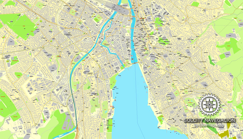
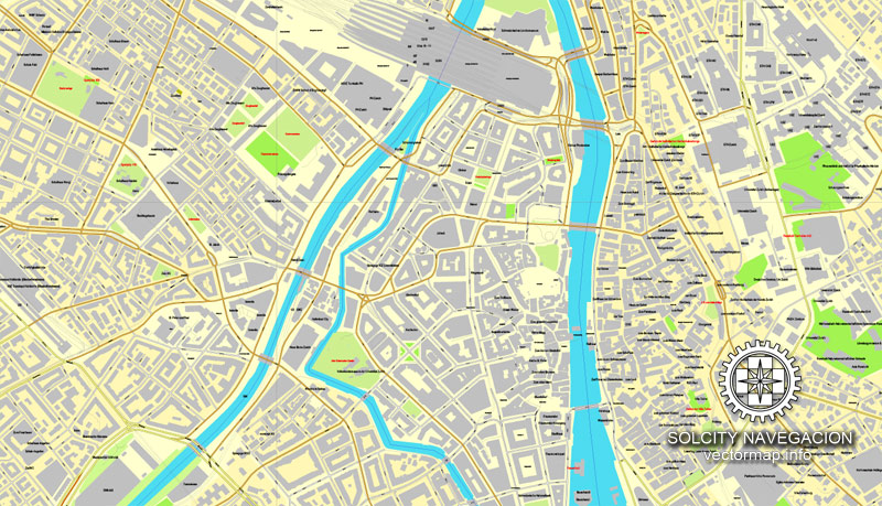
Zürich is situated at 408 m (1,339 ft) above sea level on the lower (northern) end of Lake Zürich (Zürichsee) about 30 kilometers (19 mi) north of the Alps, nestling between the wooded hills on the west and east side. The Old Town stretches on both sides of the Limmat, which flows from the lake, running northwards at first and then gradually turning into a curve to the west. The geographic (and historic) centre of the city is the Lindenhof, a small natural hill on the west bank of the Limmat, about 700 m (2,300 ft) north of where the river issues from Lake Zürich. Today the incorporated city stretches somewhat beyond the natural confines of the hills and includes some districts to the northeast in the Glatt Valley (Glattal) and to the north in the Limmat Valley (Limmattal). The boundaries of the older city are easy to recognize by the Schanzengraben canal. This artificial watercourse has been used for the construction of the third fortress in the 17th and 18th centuries.
Color groups
Is a list of all saved color groups for current document (the same groups appear in the «Samples» palette). You can edit and delete the existing color groups, as well as creating a new ones using the list of “Color Groups” in the dialog box. All changes appear in the «Samples» palette.
The highlighted color group shows, which color group is currently edited.
Any color group can be selected and edited, or used to redefine the colors in the selected vector map of Zurich city, its fragments or elements.
Saving a color group adds this group to the specified list.
Opening the «Edit Colors»/«Repaint Graphic Object» dialog box.
Open the «Edit Colors»/«Repaint Graphic Object» dialog box using one of the following methods:
«Edit»> «Edit Colors»> «Repaint Graphic object» or «Repaint With Style».
Topography
The municipality of Zürich has an area of 91.88 km2 (35.48 sq mi), of which 4.1 km2 (1.6 sq mi) is made up of Lake Zürich. The area includes a section of the northern Swiss Plateau. The banks of the Limmat constitute the densest part of the city. The river is oriented in the southeast-northwest direction, with the flat valley floor having a width of two to two to three kilometres (1.2 to 1.9 miles). The partially channeled and straightened Limmat does not flow in the central part of the valley, but always along its right (northeastern) side. The Sihl meets with the Limmat at the end of Platzspitz, which borders the Swiss National Museum. The Limmat reaches the lowest point of the municipality in Oberengstringen at 392 m (1,286 ft) above sea level.
Use these commands if you need to edit the colors in the selected vector map of Zurich city.
«Repaint Graphic object» button on the «Control» panel.
Use this button if you need to adjust colors of Zurich city vector map using the а «Repaint graphic object» dialog box.
The specified button is available if the selected vector map or its fragment contains two or more colors.
Note. This color editing method is convenient for global color adjustment in a vector map, if global colors were not used when creating a City Map of Zurich.
The «Edit colors» button or «Edit or apply colors» on the «Color Catalog» palette
Click this button if you need to edit colors on the «Color Catalog» palette or edit and then apply them to the selected Vector Map of Zurich city or its fragment.
The «Edit color group» button or «Edit or apply color group» on the «Samples» palette.
Click this button if you need to edit the colors in the specific color group or edit and apply them to the selected Vector Map of Zurich city or a group of its elements, for example, the whole layer “Streets and lines”. You can also double-click the color group in the Samples panel to open the dialog box.
If the map file is too large and your computer freezes or even can’t open it quickly:
1. Try to reduce the color resolution of the video card (display) to 256 colors while working with a large map.
2. Using Windows Task Manager, select all the application you don’t need, while working with map, just turn them off.
3. Launch Adobe Illustrator. (DO NOT OPEN the vector map file)
4. Start the Windows Task Manager using administrator rights > Find the “Illustrator” process > set the «real time» priority,
5. Open the file. When you see the LEGACY FONT popup window – click “OK” (do not update). You can restore the TEXT later.
6. Can also be useful: When file is opened – Edit > Settings > Basic Settings > disable smoothing. /// It looks scary, but works quickly)))
We recommend saving the file in Adobe Illustrator 10 version. It’s much more stable when working with VERY BIG size files.
On its west side, the Limmat valley is flanked by the wooded heights of the Albis chain, which runs along the western border. The Uetliberg is, with 869 m (2,851 ft) above sea level, the highest elevation of the surrounding area. Its summit can be reached easily by the Uetlibergbahn. From the platform of the observation tower on the summit, an impressive panorama of the city, the lake, and the Alps can be seen.
The northeast side of the Limmat valley includes a range of hills, which marks the watershed between the Limmat and the Glatt. From the northwest to the southeast, the height of the mostly wooded knolls generally increases: the Gubrist (615 m or 2,018 ft), the Hönggerberg (541 m or 1,775 ft), the Käferberg (571 m or 1,873 ft), the Zürichberg (676 m or 2,218 ft), the Adlisberg (701 m or 2,300 ft) and the Öschbrig (696 m or 2,283 ft). Between the Käferberg and the Zürichberg is located the saddle of the Milchbuck (about 470 m or 1,540 ft), an important passage from the Limmat valley to the Glatt valley.
The northernmost part of the municipality extends to the plain of the Glatt valley and to the saddle which makes the connection between the Glattal and Furttal. Also, a part of the Katzensee (nature reserve) and the Büsisee, both of which are drained by the Katzenbach to Glatt, belong to the city.
Zürich
City in Switzerland
The city of Zurich lies at the north end of Lake Zurich in northern Switzerland, a global center for banking and finance. The picturesque lanes of the central Altstadt (Old Town), on either side of the Limmat River, reflect its premedieval history. Waterfront promenades like the Limmatquai follow the river toward the 17th-century Rathaus (town hall).
Population: 378,884 (2012) UNdata
Canton: Canton of Zürich
Zürich or Zurich is the largest city in Switzerland and the capital of the canton of Zürich. It is located in north-central Switzerland at the northwestern tip of Lake Zürich. The municipality has approximately 400,028 inhabitants, the urban agglomeration 1.315 million, and the Zurich metropolitan area 1.83 million. Zürich is a hub for railways, roads, and air traffic. Both Zürich Airport and railway station are the largest and busiest in the country.
Permanently settled for around 2000 years, Zürich has a history that goes back to its founding by the Romans, who, in 15 BC, called it Turicum. However, early settlements have been found dating back more than 6400 years ago. During the Middle Ages Zürich gained the independent and privileged status of imperial immediacy and, in 1519, became a primary centre of the Protestant Reformation in Europe under the leadership of Ulrich Zwingli.
The official language of Zürich is (the Swiss variety of Standard) German, but the main spoken language is the local variant of the Alemannic Swiss German dialect.
Zürich is a leading global city and among the world’s largest financial centres despite a relatively low population. The city is home to a large number of financial institutions and banking giants. Most of Switzerland’s research and development centres are concentrated in Zürich and the low tax rates attract overseas companies to set up their headquarters there.
Monocle’s 2012 “Quality of Life Survey” ranked Zürich first on a list of the top 25 cities in the world “to make a base within”. According to several surveys from 2006 to 2008, Zürich was named the city with the best quality of life in the world as well as the wealthiest city in Europe. The Economist Intelligence Unit’s Global Liveability Ranking sees Zürich rank among the top ten most liveable cities in the world.
Many museums and art galleries can be found in the city, including the Swiss National Museum and the Kunsthaus. Schauspielhaus Zürich is one of the most important theatres in the German-speaking world.
Small guide: How to work with the vector map?
You can: Mass select objects by type and color – for example, the objects type “building” (they are usually dark gray) – and remove them from the map, if you do not need them in your print or design project. You can also easily change the thickness of lines (streets), just bulk selection the road by the line color.
The streets are separated by type, for example, type “residential road” are usually white with a gray stroke. Highway usually orange with a brown or dark gray stroke.
It is easy to change the font of inscriptions, all or each individually. Also, just can be make and any other manipulation of objects on the vector map in Adobe illustrator format.
Important: All the proportions on the map are true, that is, the relative sizes of the objects are true, because Map is based on an accurate GPS projection, and It transated into the (usual for all) the Mercator projection.
You can easily change the color, stroke and fill of any object on the map, zoom without loss of quality Image Verification.
Select object

Bulk selection the same objects on the vector map

See the bulk selected objects on the vector map

Bulk delete buildungs from the vector map

Select residencial road (small street) on the vector map

Bulk selection the same lines (streets, roads) on the full map

Create fat lines of the streets on the vector maps (bulk action) 1

Create fat lines of the streets on the vector maps (bulk action) 2

Create fat lines of the streets on the vector maps (bulk action) 3

You can easily change the color, stroke and fill of any object on the map, zoom without loss of quality Image Verification.


 Author: Kirill Shrayber, Ph.D. FRGS


 Street Map editable Adobe Illustrator in layers")