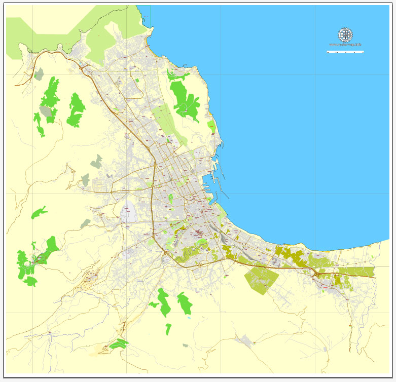
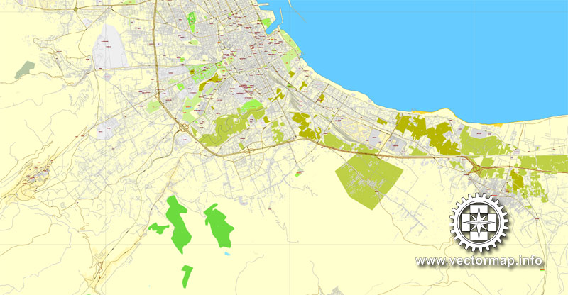
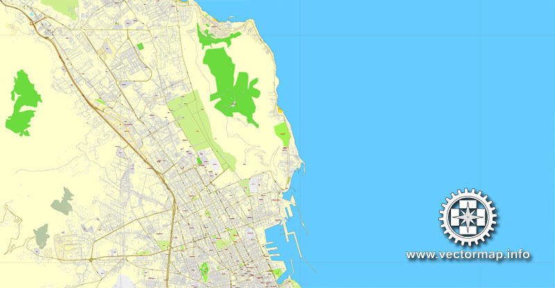
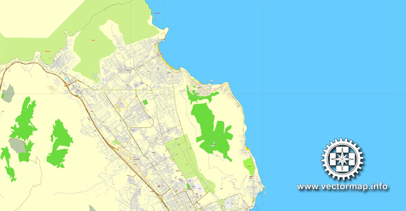
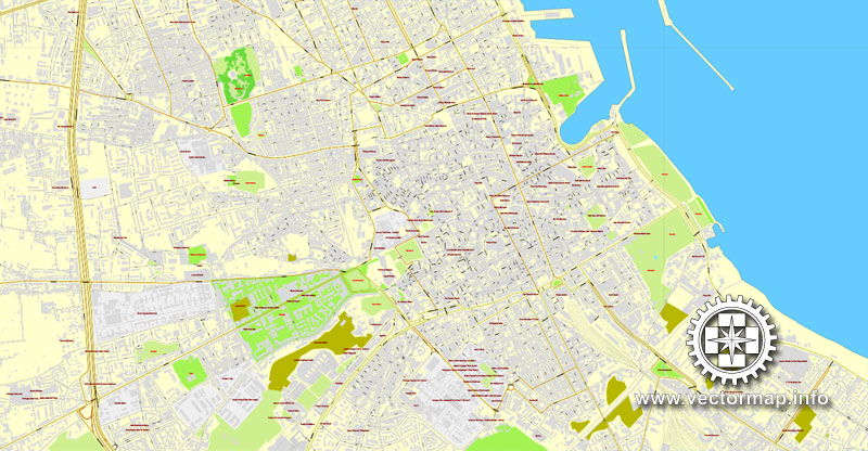
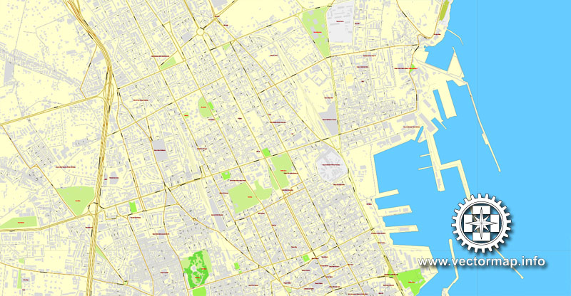
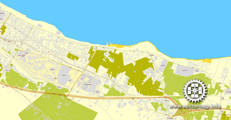
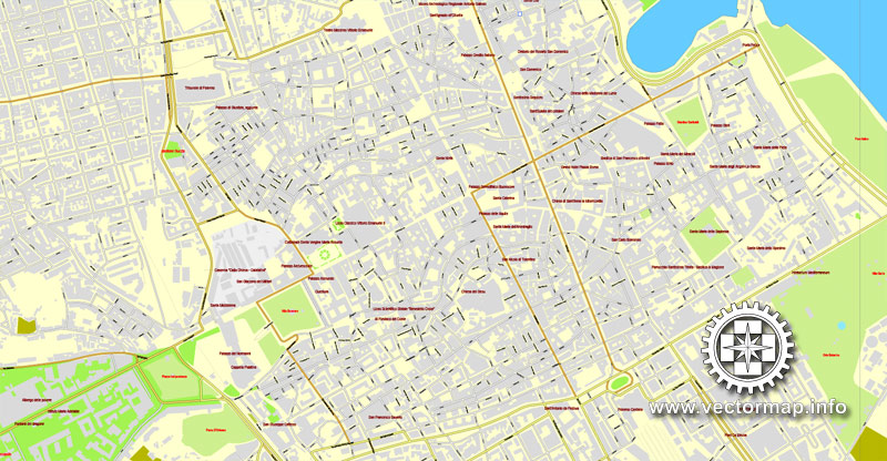
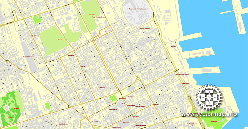
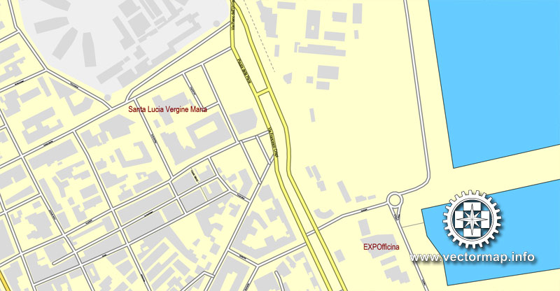
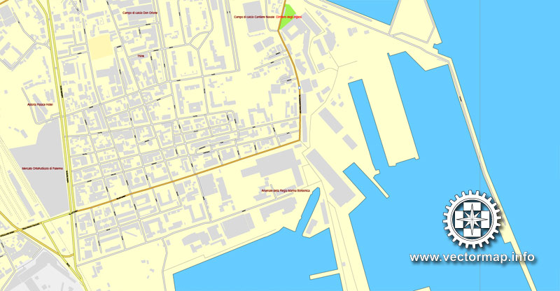
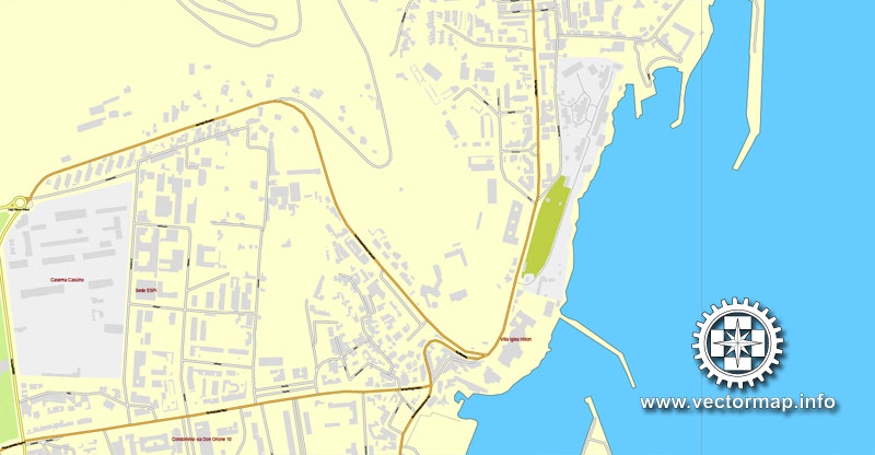
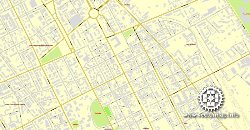
Palermo, Sicily, Italy, printable vector street map, City Plan full editable, Adobe Illustrator, Royalty free, full vector, scalable, editable, text format street names, 9,3 mb ZIP
All streets, All buildings.
Map for design, print, arts, projects, presentations, for architects, designers and builders.
Different font colors of the street names (black); object names by type (brown, red).
The most accurate and detailed map of the city.
DXF, DWG, CDR and other formats – on request, same price, please, contact
Palermo, Italy.
This vector map of Palermo is used as a basis for design, editing, and further printing.
This is the most detailed, exact map of Palermo for high-quality printing and polygraphy. You can always clarify the map development date by contacting us.
For your convenience, all objects on Palermo vector map are divided into layers. And the editing is very easy – colors, lines, etc.
You can easily add any objects needed (e.g. shops, salons, sale points, gas station or attraction) on any layer of Palermo vector map.
Palermo is a city of Southern Italy, the capital of both the autonomous region of Sicily and the Metropolitan City of Palermo. The city is noted for its history, culture, architecture and gastronomy, playing an important role throughout much of its existence; it is over 2,700 years old. Palermo is located in the northwest of the island of Sicily, right by the Gulf of Palermo in the Tyrrhenian Sea.
One of the advantages of Palermo vector maps of our production is the relevance of cartographic data, we constantly update all our products.
This vector map of Palermo is used by:
designers, layout designers, printers, advertisers and architects. Our product – vector maps – is designed for further editing and printing in large formats – from @Wall format (a few meters) to A-0 and A-1, A-2, A-3.
Palermo map in vector format is used for design, urban planning, presentations and media visualizations.
Advertising and presentation map of Palermo (usually the final designer marks the routes, and puts the client’s objects (shops, saloons, gas stations etc.)
The undoubted advantage is that people will NEVER throw out this advertising product – the map. In fact, as an advertising medium, a map is the most “long-playing” of the well-known polygraphic advertising media, with the longest lifespan, and the maximum number of interactions with the customer.
For travelers, maps are sold at the airports and gas stations around the world. Often the source is our vector maps.
Take a look, who purchases our vector maps of Palermo in “Our Clients and Friends” page – these are large and small companies, from super-brands like Volvo and Starbucks, to small design studios and printing houses.
It’s very easy to work with vector maps of Palermo, even for a not very experienced designer who can turn on and off the map layers, add new objects, change the colors of fill and lines according to customer requirements.
The undoubted advantage of Palermo vector maps in printing is an excellent and detailed visualization, when customer can expand a large paper map and instantly define his location, find a landmark, an object or address on map, unlike using the popular electronic formats of Google and Yandex maps for example.
Printable vector maps of Palermo are much more convenient and efficient than any electronic maps on your smartphone, because ALL DETAILS are displayed in the entire space of Palermo map.
Useful tips on working with vector maps of cities and countries in Adobe Illustrator.
«V» – launches the Selection tool (cursor, black arrow), which makes active any vector line.
«А» – launches the Direct Selection tool (white cursor), allows you to select curve elements and drag them to the desired place.
«R» – activates the Rotate tool, which helps you rotating selected objects around the center point by 360 degrees.
«E» – gives you the opportunity to use the Eraser tool and erase unnecessary parts.
«X» – switches between Fill and Stroke in the Tools section. Try to get used to this hot key and
you will quickly understand that you can’t live and work without it.
Guides are not limited to vertical and horizontal in Adobe Illustrator. You can also create a diagonal guide for example. Moreover, you can turn any contours into guides. Select the outline and go to View > Guides > Make Guides (Create Guides), or simply press Cmd/Ctrl + 5. You can also turn the guides back into an editable object. Go to menu, View > Guides > Unlock Guides (Release Guides), select the guide you want to edit and select View > Guides > Release Guides (Reset Guides), or just press Cmd/Ctrl + Option / Alt + 5).
You will probably want to change the color scheme used on our Palermo vector map.
To quickly and effectively play with colors.
Of course, you can do it manually, all objects in our Palermo vector map are divided according to types and layers, and you can easily change the color gamma of vector objects in groups and layers.
But there is more effective way of working with the whole VECTOR MAP of Palermo and all layers:
The overview dialog «Edit colors»/«Repaint Graphic Object» (this dialog box name can change depending on the context):
If you have selected a part or a layer of Palermo vector map and open the dialog box by clicking the icon in the Control panel, on the Samples palette or the Color Catalog, or if you choose Edit > Edit Colors> Repaint Graphic Object, then the «Repaint Graphic Object» dialog box appears, and you get access to «Assign» and «Edit» tabs.
If a picture or a map fragment is not selected, and you open the dialog box by clicking the icon in the Control panel, on the Samples palette or in the Color Catalog, the «Edit Colors» dialog box appears and you can only access the «Edit» tab.
Regardless of the name at the top of the dialog box, the right-hand side always displays the color group of the current document, as well as two default color groups: Print Color and Grayscale. These color groups can be selected and used any time.
Create and edit color groups of Palermo vector map, and also assign colors using the «Edit Colors»/ а «Repaint Graphic Object» dialog box.
A. Creating and editing of a color group on the «Edit» tab
B. Assigning colors on the «Assign» tab
C. Select a group of colors from the «Color groups» list
The option «Repaint a graphic object» in the lower part of the dialog box allows you to preview the colors on a selected layer of Vector map, or a group of elements, and specify whether its colors will be redefined when the dialog box is closed.
The main areas of the dialog box are:
«Edit»
The «Edit» tab is designed to create a new or edit the existing color groups.
The harmony rules Menu and the Color Wheel are used to conduct experiments with color harmonies. The color wheel shows how colors are related in color harmony, and the color bars allow you to view and manipulate an individual color values. In addition, you can adjust the brightness, add and remove colors, save color groups and view colors on the selected Vector Map of Palermo or a separated layers.
«Assign»
The «Assign» tab is used to view and control on how the original colors are replaced with colors from the color group like your corporate colors in the Vector Map of Palermo.
The assign color ability is provided only if the entire map, layer or fragment is selected in the document. You can specify which of new colors replace the current colors, whether the spot colors should be preserved and how colors are replaced (for example, you can replace colors completely or changing the color tone while maintaining the brightness). The «Assign» tab allows you to redefine colors in the Vector Map of Palermo, or in separate layers and fragments using the current color group or reducing the number of colors in the current Vector Map.
Color groups
Is a list of all saved color groups for current document (the same groups appear in the «Samples» palette). You can edit and delete the existing color groups, as well as creating a new ones using the list of “Color Groups” in the dialog box. All changes appear in the «Samples» palette.
The highlighted color group shows, which color group is currently edited.
Any color group can be selected and edited, or used to redefine the colors in the selected vector map of Palermo , its fragments or elements.
Saving a color group adds this group to the specified list.
Opening the «Edit Colors»/«Repaint Graphic Object» dialog box.
Open the «Edit Colors»/«Repaint Graphic Object» dialog box using one of the following methods:
«Edit»> «Edit Colors»> «Repaint Graphic object» or «Repaint With Style».
Use these commands if you need to edit the colors in the selected vector map of Palermo.
«Repaint Graphic object» button on the «Control» panel.
Use this button if you need to adjust colors of Palermo vector map using the а «Repaint graphic object» dialog box.
The specified button is available if the selected vector map or its fragment contains two or more colors.
The city was founded in 734 BC by the Phoenicians as Ziz. Palermo then became a possession of Carthage. Two Greek colonies were established, known collectively as Panormos or “All-Port”; the Carthaginians used this name on their coins after the 5th century BC. As Panormus, the town became part of the Roman Republic and Empire for over a thousand years. From 831 to 1072 the city was under Arab rule during the Emirate of Sicily when the city first became a capital. The Arabs shifted the Greek name into Bal’harm, the root for Palermo’s present-day name. Following the Norman reconquest, Palermo became the capital of a new kingdom (from 1130 to 1816), the Kingdom of Sicily and the capital of the Holy Roman Empire under Emperor Frederick II and King Conrad IV.
Note. This color editing method is convenient for global color adjustment in a vector map, if global colors were not used when creating a Map of Palermo.
The «Edit colors» button or «Edit or apply colors» on the «Color Catalog» palette
Click this button if you need to edit colors on the «Color Catalog» palette or edit and then apply them to the selected Vector Map of Palermo or its fragment.
The «Edit color group» button or «Edit or apply color group» on the «Samples» palette.
Click this button if you need to edit the colors in the specific color group or edit and apply them to the selected Vector Map of Palermo or a group of its elements, for example, the whole layer “Streets and lines”. You can also double-click the color group in the Samples panel to open the dialog box.
If the map file is too large and your computer freezes or even can’t open it quickly:
1. Try to reduce the color resolution of the video card (display) to 256 colors while working with a large map.
2. Using Windows Task Manager, select all the application you don’t need, while working with map, just turn them off.
3. Launch Adobe Illustrator. (DO NOT OPEN the vector map file)
4. Start the Windows Task Manager using administrator rights > Find the “Illustrator” process > set the «real time» priority,
5. Open the file. When you see the LEGACY FONT popup window – click “OK” (do not update). You can restore the TEXT later.
6. Can also be useful: When file is opened – Edit > Settings > Basic Settings > disable smoothing. /// It looks scary, but works quickly)))
We recommend saving the file in Adobe Illustrator 10 version. It’s much more stable when working with VERY BIG size files.
The population of Palermo urban area is estimated by Eurostat to be 855,285, while its metropolitan area is the fifth most populated in Italy with around 1.2 million people. In the central area, the city has a population of around 676,000 people. The inhabitants are known as Palermitani or, poetically, panormiti. The languages spoken by its inhabitants are the Italian language and the Palermitano dialect of the Sicilian language.
Palermo is Sicily’s cultural, economic and tourism capital. It is a city rich in history, culture, art, music and food. Numerous tourists are attracted to the city for its good Mediterranean weather, its renowned gastronomy and restaurants, its Romanesque, Gothic and Baroque churches, palaces and buildings, and its nightlife and music. Palermo is the main Sicilian industrial and commercial center: the main industrial sectors include tourism, services, commerce and agriculture. Palermo currently has an international airport, and a significant underground economy. In fact, for cultural, artistic and economic reasons, Palermo was one of the largest cities in the Mediterranean and is now among the top tourist destinations in both Italy and Europe. It is the main seat of the UNESCO World Heritage Site Arab-Norman Palermo and the Cathedral Churches of Cefalù and Monreale. The city is also going through careful redevelopment, preparing to become one of the major cities of the Euro-Mediterranean area.
Roman Catholicism is highly important in Palermitano culture. The Patron Saint of Palermo is Santa Rosalia whose Feast Day is celebrated on 15 July. The area attracts significant numbers of tourists each year and is widely known for its colourful fruit, vegetable and fish markets at the heart of Palermo, known as Vucciria, Ballarò and Capo.
Geography
Palermo lies in a basin, formed by the Papireto, Kemonia and Oreto rivers. The basin was named the Conca d’Oro (the Golden Basin) by the Arabs in the 9th century. The city is surrounded by a mountain range which is named after the city itself. These mountains face the Tyrrhenian Sea. Palermo is home to a natural port and offers excellent views to the sea, especially from Monte Pellegrino.
Palermo
City in Italy
Palermo is the capital of the Italian island of Sicily. The 12th-century Palermo Cathedral houses royal tombs, while the huge neoclassical Teatro Massimo is known for opera performances. Also in the center are the Palazzo dei Normanni, a royal palace started in the 9th century, and the Cappella Palatina, with Byzantine mosaics. Busy markets include the central Ballarò street market and the Vucciria, near the port.
Region: Sicily
University: University of Palermo
Palermo is a city of Southern Italy, the capital of both the autonomous region of Sicily and the Metropolitan City of Palermo. The city is noted for its history, culture, architecture and gastronomy, playing an important role throughout much of its existence; it is over 2,700 years old. Palermo is located in the northwest of the island of Sicily, right by the Gulf of Palermo in the Tyrrhenian Sea.
The city was founded in 734 BC by the Phoenicians as Ziz (‘flower’). Palermo then became a possession of Carthage, before becoming part of the Roman Republic, the Roman Empire and eventually part of the Byzantine Empire, for over a thousand years. The Greeks named the city Panormus meaning ‘complete port’. From 831 to 1072 the city was under Arab rule during the Emirate of Sicily when the city first became a capital. The Arabs shifted the Greek name into Balarm, the root for Palermo’s present-day name. Following the Norman reconquest, Palermo became the capital of a new kingdom (from 1130 to 1816), the Kingdom of Sicily and the capital of the Holy Roman Empire under Frederick II Holy Roman Emperor and Conrad IV of Germany, King of the Romans. Eventually Sicily would be united with the Kingdom of Naples to form the Kingdom of the Two Sicilies until the Italian unification of 1860.
The population of Palermo urban area is estimated by Eurostat to be 855,285, while its metropolitan area is the fifth most populated in Italy with around 1.2 million people. In the central area, the city has a population of around 676,000 people. The inhabitants are known as Palermitani or, poetically, panormiti. The languages spoken by its inhabitants are the Italian language, Sicilian language and the Palermitano dialect.
Palermo is Sicily’s cultural, economic and touristic capital. It is a city rich in history, culture, art, music and food. Numerous tourists are attracted to the city for its good Mediterranean weather, its renowned gastronomy and restaurants, its Romanesque, Gothic and Baroque churches, palaces and buildings, and its nightlife and music. Palermo is the main Sicilian industrial and commercial center: the main industrial sectors include tourism, services, commerce and agriculture. Palermo currently has an international airport, and a significant underground economy. In fact, for cultural, artistic and economic reasons, Palermo was one of the largest cities in the Mediterranean and is now among the top tourist destinations in both Italy and Europe. It is the main seat of the UNESCO World Heritage Site of Arab-Norman Palermo and the Cathedral Churches of Cefalù and Monreale. The city is also going through careful redevelopment, preparing to become one of the major cities of the Euro-Mediterranean area.
Roman Catholicism is highly important in Palermitano culture. The Patron Saint of Palermo is Santa Rosalia whose Feast Day is celebrated on 15 July. The area attracts significant numbers of tourists each year and is widely known for its colourful fruit, vegetable and fish markets at the heart of Palermo, known as Vucciria, Ballarò and Capo. Source Wiki

Free vector map World, Adobe Illustrator, download now maps vector clipart Map for design, projects, presentation free to use as you like. World map vector, Vector world map, World vector map, Map western europe, West europe maps, Map of the world modifiable, High resolution world map, World map illustrator, World map PDF editable, World vector map download,
Free vector map World, Adobe Illustrator, download now maps vector clipart
Map for design, projects, presentation free to use as you like.
Free Download All World Vector Maps here >>>>>
See also: TERMS & CONDITIONS: SOFTWARE LICENSE AGREEMENT FOR DIGITAL CARTOGRAPHIC DATA
Small guide: How to work with the vector map?
You can: Mass select objects by type and color – for example, the objects type “building” (they are usually dark gray) – and remove them from the map, if you do not need them in your print or design project. You can also easily change the thickness of lines (streets), just bulk selection the road by the line color.
The streets are separated by type, for example, type “residential road” are usually white with a gray stroke. Highway usually orange with a brown or dark gray stroke.
All objects are divided by types: different types of roads and streets, polygons of buildings, landfills, urban areas, parks and more other.
It is easy to change the font of inscriptions, all or each individually. Also, just can be make and any other manipulation of objects on the vector map in Adobe illustrator format.
Important: All the proportions on the map are true, that is, the relative sizes of the objects are true, because Map is based on an accurate GPS projection, and It transated into the (usual for all) the Mercator projection.
You can easily change the color, stroke and fill of any object on the map, zoom without loss of quality Image Verification.
Select object

Bulk selection the same objects on the vector map

See the bulk selected objects on the vector map

Bulk delete buildungs from the vector map

Select residencial road (small street) on the vector map

Bulk selection the same lines (streets, roads) on the full map

Create fat lines of the streets on the vector maps (bulk action) 1

Create fat lines of the streets on the vector maps (bulk action) 2

Create fat lines of the streets on the vector maps (bulk action) 3

You can easily change the color, stroke and fill of any object on the map, zoom without loss of quality Image Verification.

 Author: Kirill Shrayber, Ph.D. FRGS
