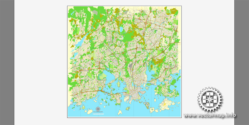
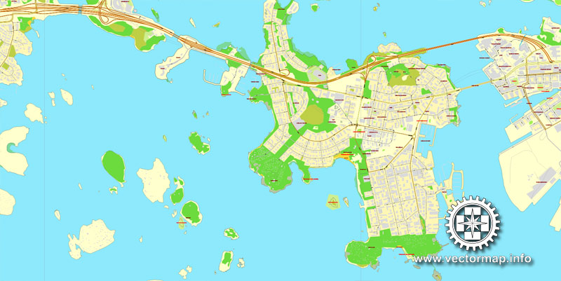
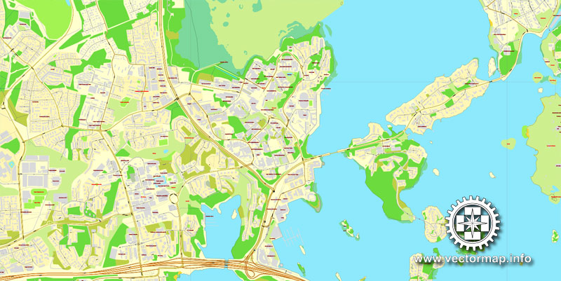
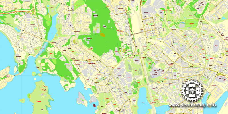
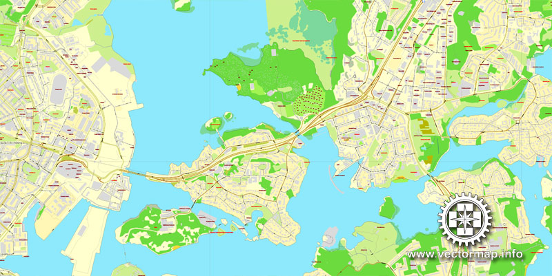
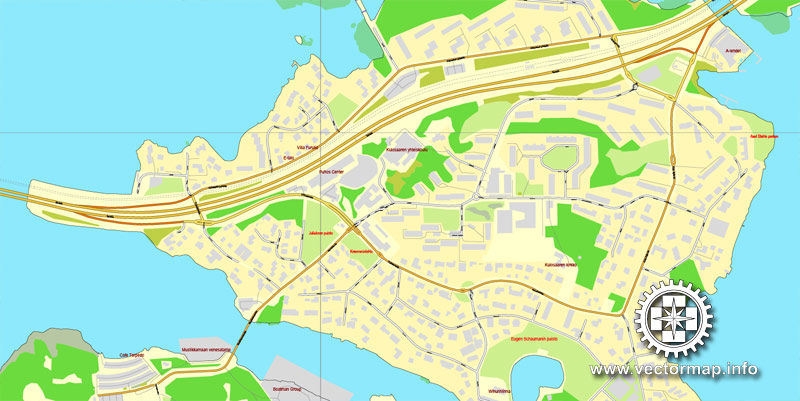
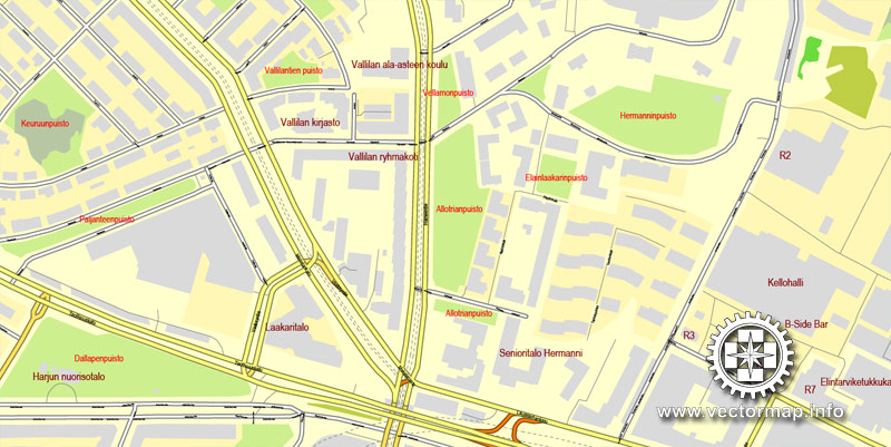
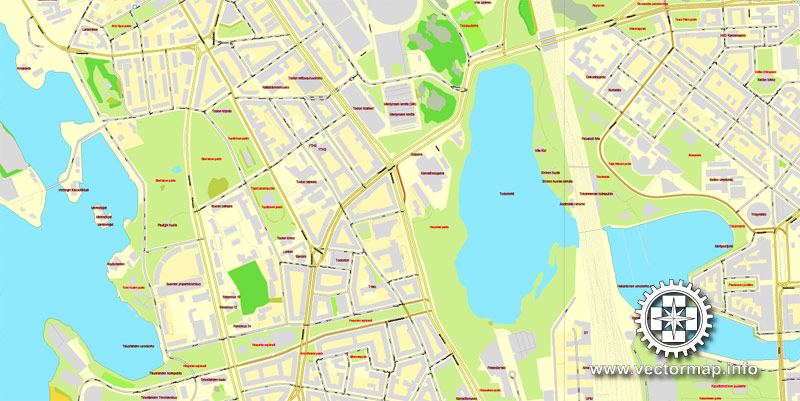
Helsinki, Finland, printable vector street City Plan map V.2, full editable, Adobe Illustrator, full vector, scalable, editable, text format street names, 20,3 mb ZIP
All streets, All buildings. Map for design, print, arts, projects, presentations.
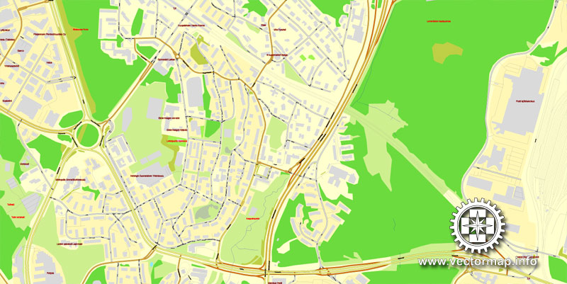
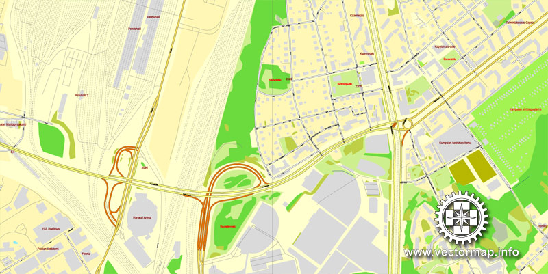
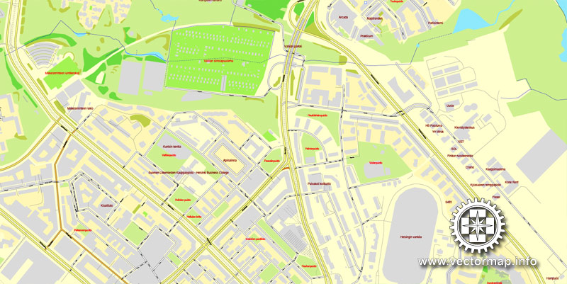
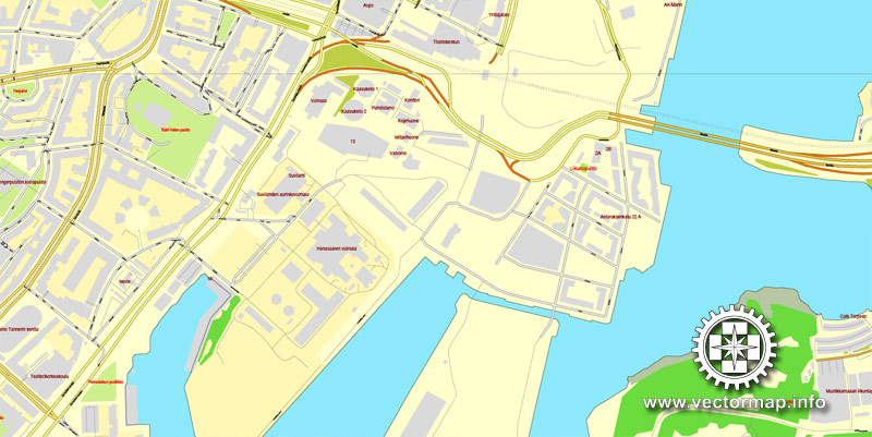
The most accurate and detailed map of the city.
Try turning the display mode VIEW/OUTLINE – you’ll see a lot of interesting things)))
DXF, DWG, CDR and other formats – on request, same price, please, contact
Helsinki, Finland.
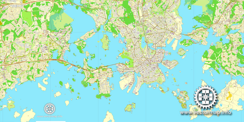
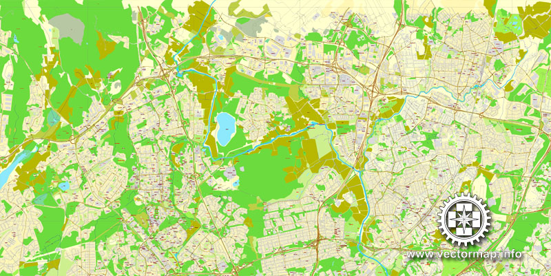
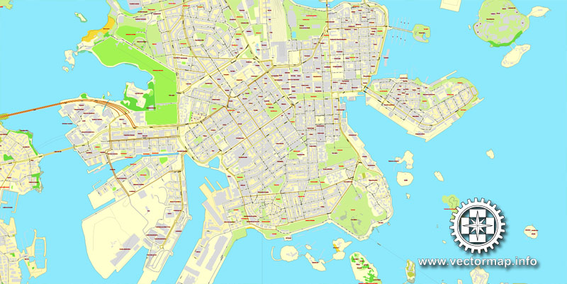
This vector map of Helsinki city is used as a basis for design, editing, and further printing.
This is the most detailed, exact map of Helsinki city for high-quality printing and polygraphy. You can always clarify the map development date by contacting us.
For your convenience, all objects on Helsinki vector city map are divided into layers. And the editing is very easy – colors, lines, etc.
You can easily add any objects needed (e.g. shops, salons, sale points, gas station or attraction) on any layer of Helsinki vector map.
Helsinki is the capital city and most populous municipality of Finland. Located on the shore of the Gulf of Finland, it is the seat of the region of Uusimaa in southern Finland, and has a population of 648,650. The city’s urban area has a population of 1,268,296, making it by far the most populous urban area in Finland as well as the country’s most important center for politics, education, finance, culture, and research. Helsinki is located 80 kilometres (50 mi) north of Tallinn, Estonia, 400 km (250 mi) east of Stockholm, Sweden, and 390 km (240 mi) west of Saint Petersburg, Russia. It has close historical ties with these three cities.
One of the advantages of Helsinki city vector maps of our production is the relevance of cartographic data, we constantly update all our products.
This vector map of Helsinki city is used by:
designers, layout designers, printers, advertisers and architects. Our product – vector maps – is designed for further editing and printing in large formats – from @Wall format (a few meters) to A-0 and A-1, A-2, A-3.
The Helsinki city map in vector format is used for design, urban planning, presentations and media visualizations.
The advertising and presentation map of Helsinki city (usually the final designer marks the routes, and puts the client’s objects (shops, saloons, gas stations etc.)
The undoubted advantage is that people will NEVER throw out this advertising product – the map. In fact, as an advertising medium, a city map is the most “long-playing” of the well-known polygraphic advertising media, with the longest lifespan, and the maximum number of interactions with the customer.
Together with the cities of Espoo, Vantaa, and Kauniainen, and surrounding commuter towns, Helsinki forms the Greater Helsinki metropolitan area, which has a population of nearly 1.5 million. Often considered to be Finland’s only metropolis, it is the world’s northernmost metro area with over one million people as well as the northernmost capital of an EU member state. After Stockholm and Oslo, Helsinki is the third largest city in the Nordic countries. The city is served by the international Helsinki Airport, located in the neighboring city of Vantaa, with frequent service to many destinations in Europe and Asia.
For travelers, maps are sold at the airports and gas stations around the world. Often the source is our vector maps.
Take a look, who purchases our vector maps of Helsinki city in “Our Clients and Friends” page – these are large and small companies, from super-brands like Volvo and Starbucks, to small design studios and printing houses.
It’s very easy to work with vector maps of Helsinki city, even for a not very experienced designer who can turn on and off the map layers, add new objects, change the colors of fill and lines according to customer requirements.
The undoubted advantage of Helsinki city vector maps in printing is an excellent and detailed visualization, when customer can expand a large paper map and instantly define his location, find a landmark, an object or address on map, unlike using the popular electronic formats of Google and Yandex maps for example.
Helsinki was the World Design Capital for 2012, the venue for the 1952 Summer Olympics, and the host of the 52nd Eurovision Song Contest.
Helsinki has one of the highest urban standards of living in the world. In 2011, the British magazine Monocle ranked Helsinki the world’s most liveable city in its liveable cities index. In the Economist Intelligence Unit’s 2016 liveability survey, Helsinki was ranked ninth among 140 cities.

Printable vector maps of Helsinki city are much more convenient and efficient than any electronic maps on your smartphone, because ALL DETAILS are displayed in the entire space of Helsinki city map.
Useful tips on working with vector maps of cities and countries in Adobe Illustrator.
«V» – launches the Selection tool (cursor, black arrow), which makes active any vector line.
«А» – launches the Direct Selection tool (white cursor), allows you to select curve elements and drag them to the desired place.
«R» – activates the Rotate tool, which helps you rotating selected objects around the center point by 360 degrees.
«E» – gives you the opportunity to use the Eraser tool and erase unnecessary parts.
«X» – switches between Fill and Stroke in the Tools section. Try to get used to this hot key and
you will quickly understand that you can’t live and work without it.
Geography
Called the “Daughter of the Baltic”, Helsinki is on the tip of a peninsula and on 315 islands. The inner city is located on a southern peninsula, Helsinginniemi (”Helsinki’s peninsula”), which is rarely referred to by its actual name, Vironniemi (”Estonia’s peninsula”). Population density in certain parts of Helsinki’s inner city area is very high, reaching 16,494 inhabitants per square kilometre (42,720/sq mi) in the district of Kallio, but as a whole Helsinki’s population density of 3,050 per square kilometre (7,900/sq mi) ranks the city as rather sparsely populated in comparison to other European capital cities.
Guides are not limited to vertical and horizontal in Adobe Illustrator. You can also create a diagonal guide for example. Moreover, you can turn any contours into guides. Select the outline and go to View > Guides > Make Guides (Create Guides), or simply press Cmd/Ctrl + 5. You can also turn the guides back into an editable object. Go to menu, View > Guides > Unlock Guides (Release Guides), select the guide you want to edit and select View > Guides > Release Guides (Reset Guides), or just press Cmd/Ctrl + Option / Alt + 5).
You will probably want to change the color scheme used on our Helsinki vector city map.
To quickly and effectively play with colors.
Of course, you can do it manually, all objects in our Helsinki city vector map are divided according to types and layers, and you can easily change the color gamma of vector objects in groups and layers.
But there is more effective way of working with the whole VECTOR MAP of Helsinki city and all layers:
The overview dialog «Edit colors»/«Repaint Graphic Object» (this dialog box name can change depending on the context):
If you have selected a part or a layer of Helsinki city vector map and open the dialog box by clicking the icon in the Control panel, on the Samples palette or the Color Catalog, or if you choose Edit > Edit Colors> Repaint Graphic Object, then the «Repaint Graphic Object» dialog box appears, and you get access to «Assign» and «Edit» tabs.
Outside of the inner city, much of Helsinki consists of postwar suburbs separated by patches of forest. A narrow, 10 kilometres (6.2 mi) long Helsinki Central Park, stretching from the inner city to Helsinki’s northern border, is an important recreational area for residents. The City of Helsinki has about 11,000 boat berths and possesses over 14,000 hectares of marine fishing waters adjacent to the Capital Region. Some 60 fish species are found in this area and recreational fishing is popular.
If a picture or a map fragment is not selected, and you open the dialog box by clicking the icon in the Control panel, on the Samples palette or in the Color Catalog, the «Edit Colors» dialog box appears and you can only access the «Edit» tab.
Regardless of the name at the top of the dialog box, the right-hand side always displays the color group of the current document, as well as two default color groups: Print Color and Grayscale. These color groups can be selected and used any time.
Create and edit color groups of Helsinki city vector map, and also assign colors using the «Edit Colors»/ а «Repaint Graphic Object» dialog box.
A. Creating and editing of a color group on the «Edit» tab
B. Assigning colors on the «Assign» tab
C. Select a group of colors from the «Color groups» list
The option «Repaint a graphic object» in the lower part of the dialog box allows you to preview the colors on a selected layer of Vector map, or a group of elements, and specify whether its colors will be redefined when the dialog box is closed.
Major islands in Helsinki include Seurasaari, Vallisaari, Lauttasaari, and Korkeasaari – the lattermost being the site of Finland’s largest zoo. Other noteworthy islands are the fortress island of Suomenlinna (Sveaborg), the military island of Santahamina, and Isosaari. Pihlajasaari island is a favorite summer spot for gay men and naturists, comparable to Fire Island in New York City.
The main areas of the dialog box are:
«Edit»
The «Edit» tab is designed to create a new or edit the existing color groups.
The harmony rules Menu and the Color Wheel are used to conduct experiments with color harmonies. The color wheel shows how colors are related in color harmony, and the color bars allow you to view and manipulate an individual color values. In addition, you can adjust the brightness, add and remove colors, save color groups and view colors on the selected Vector Map of Helsinki city or a separated layers.
«Assign»
The «Assign» tab is used to view and control on how the original colors are replaced with colors from the color group like your corporate colors in the Vector Map of Helsinki city.
The assign color ability is provided only if the entire map, layer or fragment is selected in the document. You can specify which of new colors replace the current colors, whether the spot colors should be preserved and how colors are replaced (for example, you can replace colors completely or changing the color tone while maintaining the brightness). The «Assign» tab allows you to redefine colors in the Vector Map of Helsinki city, or in separate layers and fragments using the current color group or reducing the number of colors in the current Vector Map.
Metropolitan area
The Helsinki metropolitan area, also known as the Capital Region (Finnish: Pääkaupunkiseutu, Swedish: Huvudstadsregionen) comprises four municipalities: Helsinki, Espoo, Vantaa, and Kauniainen. The Helsinki urban area is considered to be the only metropolis in Finland. It has a population of over 1,1 million, and is the most densely populated area of Finland. The Capital Region spreads over a land area of 770 square kilometres (300 sq mi) and has a population density of 1,418 inhabitants per square kilometre (3,670/sq mi). With over 20 percent of the country’s population in just 0.2 percent of its surface area, the area’s housing density is high by Finnish standards.
Color groups
Is a list of all saved color groups for current document (the same groups appear in the «Samples» palette). You can edit and delete the existing color groups, as well as creating a new ones using the list of “Color Groups” in the dialog box. All changes appear in the «Samples» palette.
The highlighted color group shows, which color group is currently edited.
Any color group can be selected and edited, or used to redefine the colors in the selected vector map of Helsinki city, its fragments or elements.
Saving a color group adds this group to the specified list.
Opening the «Edit Colors»/«Repaint Graphic Object» dialog box.
Open the «Edit Colors»/«Repaint Graphic Object» dialog box using one of the following methods:
«Edit»> «Edit Colors»> «Repaint Graphic object» or «Repaint With Style».
Use these commands if you need to edit the colors in the selected vector map of Helsinki city.
«Repaint Graphic object» button on the «Control» panel.
Use this button if you need to adjust colors of Helsinki city vector map using the а «Repaint graphic object» dialog box.
The Helsinki Metropolitan Area (Greater Helsinki) consists of the cities of Helsinki Capital Region and ten surrounding municipalities. The Metropolitan Area covers 3,697 square kilometres (1,427 sq mi) and has a population of over 1.4 million, or about a fourth of the total population of Finland. The metropolitan area has a high concentration of employment: approximately 750,000 jobs. Despite the intensity of land use, the region also has large recreational areas and green spaces. The Greater Helsinki area is the world’s northernmost urban area with a population of over one million people, and the northernmost EU capital city.
The specified button is available if the selected vector map or its fragment contains two or more colors.
Note. This color editing method is convenient for global color adjustment in a vector map, if global colors were not used when creating a City Map of Helsinki.
The «Edit colors» button or «Edit or apply colors» on the «Color Catalog» palette
Click this button if you need to edit colors on the «Color Catalog» palette or edit and then apply them to the selected Vector Map of Helsinki city or its fragment.
The «Edit color group» button or «Edit or apply color group» on the «Samples» palette.
Click this button if you need to edit the colors in the specific color group or edit and apply them to the selected Vector Map of Helsinki city or a group of its elements, for example, the whole layer “Streets and lines”. You can also double-click the color group in the Samples panel to open the dialog box.
The Helsinki urban area is an officially recognized urban area in Finland, defined by its population density. The area stretches throughout 11 municipalities, and is the largest such area in Finland, with a land area of 66,931 square kilometres (25,842 sq mi) and approximately 1,2 million inhabitants.
If the map file is too large and your computer freezes or even can’t open it quickly:
1. Try to reduce the color resolution of the video card (display) to 256 colors while working with a large map.
2. Using Windows Task Manager, select all the application you don’t need, while working with map, just turn them off.
3. Launch Adobe Illustrator. (DO NOT OPEN the vector map file)
4. Start the Windows Task Manager using administrator rights > Find the “Illustrator” process > set the «real time» priority,
5. Open the file. When you see the LEGACY FONT popup window – click “OK” (do not update). You can restore the TEXT later.
6. Can also be useful: When file is opened – Edit > Settings > Basic Settings > disable smoothing. /// It looks scary, but works quickly)))
We recommend saving the file in Adobe Illustrator 10 version. It’s much more stable when working with VERY BIG size files.
Cityscape
Carl Ludvig Engel, appointed to plan a new city centre on his own, designed several neoclassical buildings in Helsinki. The focal point of Engel’s city plan was the Senate Square. It is surrounded by the Government Palace (to the east), the main building of Helsinki University (to the west), and (to the north) the large Helsinki Cathedral, which was finished in 1852, twelve years after Engel’s death. Helsinki’s epithet, “The White City of the North”, derives from this construction era.
Helsinki is also home to numerous Art Nouveau-influenced (Jugend in Finnish) buildings belonging to the romantic nationalism trend, designed in the early 20th century and strongly influenced by Kalevala, which was a common theme of the era. Helsinki’s Art Nouveau style is also featured in central residential districts, such as Katajanokka and Ullanlinna. An important architect of the Finnish Art Nouveau style was Eliel Saarinen, whose architectural masterpiece was the Helsinki Central Station.
Helsinki also features several buildings by Finnish architect Alvar Aalto, recognized as one of the pioneers of architectural functionalism. However, some of his works, such as the headquarters of the paper company Stora Enso and the concert venue Finlandia Hall, have been subject to divided opinions from the citizens.
Functionalist buildings in Helsinki by other architects include the Olympic Stadium, the Tennis Palace, the Rowing Stadium, the Swimming Stadium, the Velodrome, the Glass Palace, the Töölö Sports Hall, and Helsinki-Malmi Airport. The sports venues were built to serve the 1940 Helsinki Olympic Games; the games were initially cancelled due to the Second World War, but the venues fulfilled their purpose in the 1952 Olympic Games. Many of them are listed by DoCoMoMo as significant examples of modern architecture. The Olympic Stadium and Helsinki-Malmi Airport are also catalogued by the Finnish National Board of Antiquities as cultural-historical environments of national significance.
Helsinki’s neoclassical buildings were often used as a backdrop for scenes set to take place in the Soviet Union in many Cold War era Hollywood movies, when filming in the USSR was not possible. Some of them include The Kremlin Letter (1970), Reds (1981), and Gorky Park (1983). Because some streetscapes were reminiscent of Leningrad’s and Moscow’s old buildings, they too were used in movie productions. At the same time the government secretly instructed Finnish officials not to extend assistance to such film projects.
In the 21st century Helsinki has decided to allow the construction of skyscrapers. As of April 2017 there are no skyscrapers taller than 100 meters in the Helsinki area, but there are several projects under construction or planning, mainly in Pasila and Kalasatama. An international architecture competition for at least 10 high-rises to be built in Pasila is being held. Construction of the towers will start before 2020. In Kalasatama, the first 35-story (130 m) and 32-story (122 m) residential towers are already under construction. Later they will be joined by a 37-story (140 metres), two 32-story (122 metres, 400 feet), 31-story (120 metres), and 27-story (100 metres) residential buildings. In the Kalasatama area, there will be about 15 high-rises within 10 years.
Helsinki
Capital of Finland
Helsinki, Finland’s southern capital, sits on a peninsula in the Gulf of Finland. Its central artery, Mannerheimintie, is flanked by institutions including the National Museum, tracing Finnish history from the Stone Age to the present, imposing Parliament House and Kiasma contemporary art museum. On busy Senate Square, the neoclassical Helsinki Cathedral stands in contrast with Uspenski Cathedral and its cupolas.
Population: 599,676 (2012) UNdata
Helsinki is the capital and largest city of Finland. It is in the region of Uusimaa, in southern Finland, on the shore of the Gulf of Finland. Helsinki has a population of 629,512, an urban population of 1,214,210, and a metropolitan population of over 1.4 million, making it the most populous municipality and urban area in Finland. Helsinki is located some 80 kilometres (50 mi) north of Tallinn, Estonia, 400 km (250 mi) east of Stockholm, Sweden, and 388 km (241 mi) west of Saint Petersburg, Russia. Helsinki has close historical connections with these three cities.
The Helsinki metropolitan area includes the urban core of Helsinki, Espoo, Vantaa, Kauniainen, and surrounding commuter towns. It is the world’s northernmost metro area of over one million people, and the city is the northernmost capital of an EU member state. The Helsinki metropolitan area is the fourth largest metropolitan area in the Nordic countries, the City of Helsinki being the third largest after Stockholm and Oslo.
Helsinki is Finland’s major political, educational, financial, cultural, and research center as well as one of northern Europe’s major cities. Approximately 75% of foreign companies operating in Finland have settled in the Helsinki region. The nearby municipality of Vantaa is the location of Helsinki Airport, with frequent service to various destinations in Europe and Asia.
In 2009, Helsinki was chosen to be the World Design Capital for 2012 by the International Council of Societies of Industrial Design, narrowly beating Eindhoven for the title. The city was the venue for the 1952 Summer Olympics and the 52nd Eurovision Song Contest 2007.
In 2011, the Monocle magazine ranked Helsinki the most liveable city in the world in its “Liveable Cities Index 2011”. In the Economist Intelligence Unit’s August 2015 Liveability survey, assessing the best and worst cities to live in globally, Helsinki placed among the world’s top ten cities.
Small guide: How to work with the vector map?
You can: Mass select objects by type and color – for example, the objects type “building” (they are usually dark gray) – and remove them from the map, if you do not need them in your print or design project. You can also easily change the thickness of lines (streets), just bulk selection the road by the line color.
The streets are separated by type, for example, type “residential road” are usually white with a gray stroke. Highway usually orange with a brown or dark gray stroke.
It is easy to change the font of inscriptions, all or each individually. Also, just can be make and any other manipulation of objects on the vector map in Adobe illustrator format.
Important: All the proportions on the map are true, that is, the relative sizes of the objects are true, because Map is based on an accurate GPS projection, and It transated into the (usual for all) the Mercator projection.
You can easily change the color, stroke and fill of any object on the map, zoom without loss of quality Image Verification.
Select object

Bulk selection the same objects on the vector map

See the bulk selected objects on the vector map

Bulk delete buildungs from the vector map

Select residencial road (small street) on the vector map

Bulk selection the same lines (streets, roads) on the full map

Create fat lines of the streets on the vector maps (bulk action) 1

Create fat lines of the streets on the vector maps (bulk action) 2

Create fat lines of the streets on the vector maps (bulk action) 3

You can easily change the color, stroke and fill of any object on the map, zoom without loss of quality Image Verification.
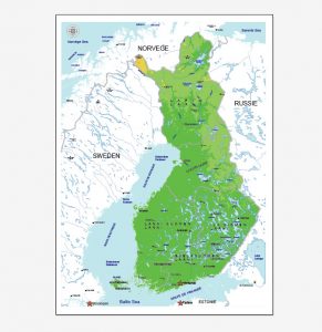
Free vector maps? Yes, we also have a small collection of free printable maps for design, arts and printing.
For example – free printable map of Finland in Adobe Illustrator format

 Author: Kirill Shrayber, Ph.D. FRGS


