Extended Description of the Vector Map
Printable PDF Vector Map of University of Central Florida US High detailed street map scale 1:4124 fully editable Layered Adobe PDF scalable, text format all names, 14 MB ZIP
All street names, Main Objects, Buildings. Map for design, printing, arts, projects, presentations, for architects, designers, and builders, business, logistics.
Note: All layers in the preview are enabled and displayed, you may not need all layers – just disable the layers you don’t need.
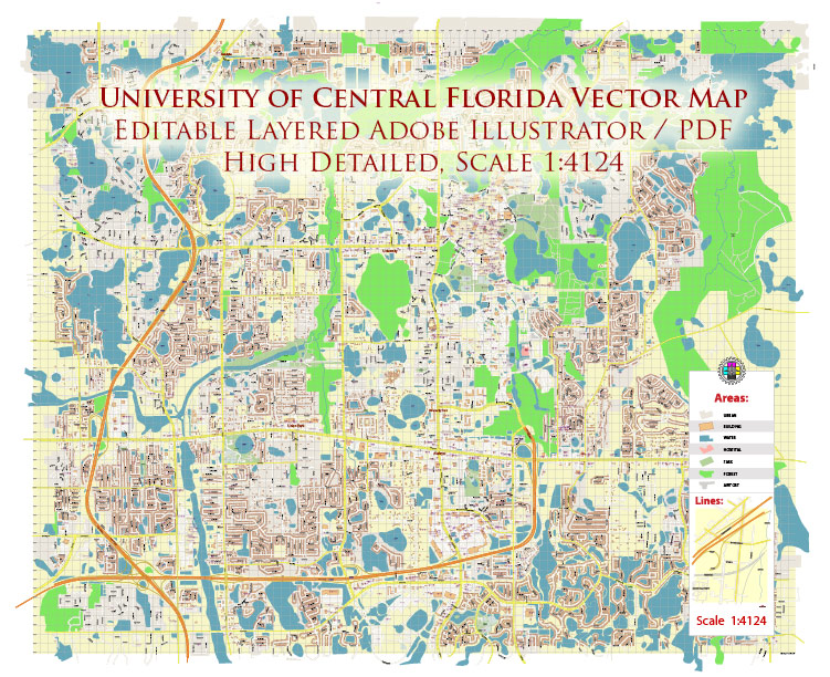
University of Central Florida US PDF Map Vector Exact Plan High Detailed Street Map editable Adobe PDF in layers
Layers list:
- Legend
- Labels of roads
- Names of places (city, hamlet, etc.)
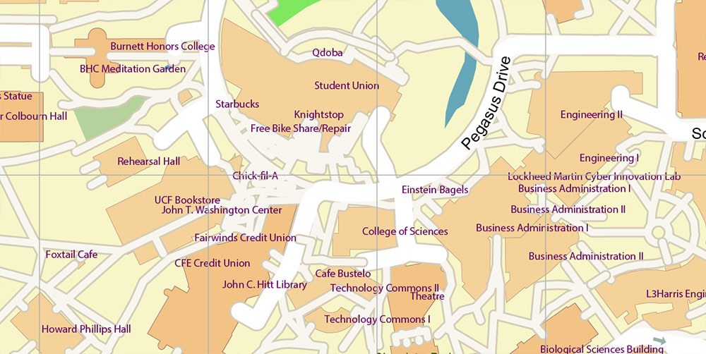
- Names of places 2 (buildings)
- Names of objects (parks, water)
- Names of main streets
- Names of civil streets
- Arrows of streets
- Main Streets, roads
- Residential streets
- Buildings
- Buildings 2 transparent 70%
- Water objects (rivers, lakes, ponds)
- Waterways
- Color fills (parks, land use, etc.)
- Background
The most exact and detailed map of the University of Central Florida US in scale.
For Editing and High-Quality Printing
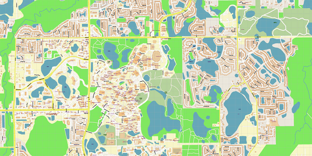
University of Central Florida (UCF) & Environs
1) Area Overview
-
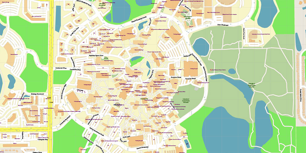
AO: UCF Main Campus, East Orlando. Core geometry is a ring road (Gemini Blvd N/E/S/W) with interior spines (Libra Dr, North/South Orion Blvd, Pegasus Dr).
-
Natural features: Lake Claire (NW) and the UCF Arboretum (E/NE) with wetlands/flatwoods.
-
Adjacent installation: Central Florida Research Park immediately E/SE of campus (defense/tech tenants).
2) Lines of Communication (LOC)
-
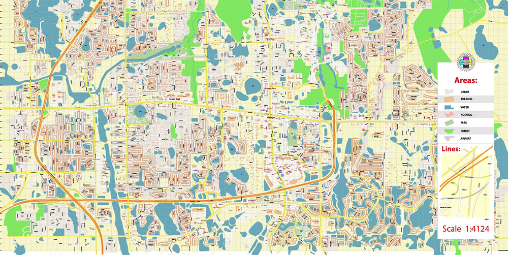
Primary arterial (W flank): Alafaya Trail / SR-434 → multiple eastbound entries (Central Florida Blvd, University Blvd, Gemini/Orion).
-
South ingress: University Blvd → main entrance and ring access. Wider grid via SR-50 (East Colonial Dr), SR-408 and SR-417.
-
North/East egress: McCulloch Rd, Lockwood Blvd, North Orion Blvd. Research Park circulation via Research Pkwy.
3) Key Terrain / Sites (KT)
-
Football Stadium (NE quadrant; mass-gathering node).
-
Addition Financial Arena (E side of ring; indoor events).
-
Student Core: Student Union and Reflecting Pond (symbolic center).
-
Recreation: Lake Claire access; Arboretum trailheads.
-
On-campus lodging / VIP: The Celeste Hotel (campus/Research Park edge).
-
Law & Order: UCF Police Department HQ on Libra Dr (with Emergency Management nearby).
4) History Snapshot
5) Demography / Human Terrain
-
Scale: ~70,000 students across 13 colleges; large commuter share plus substantial on-campus housing.
-
Composition: Mixed Florida in-state majority, strong Hispanic share, notable international presence; steady STEM/business pipeline.
6) Movement & Parking
-
Internal circulation: Gemini Blvd loop is the spine; structured garages (A–H) feed pedestrian cores.
-
Event patterns: Stadium/arena operations flip traffic emphasis to N/E sectors; common one-way/event control; egress heavy to McCulloch/Lockwood and SR-434.
7) Hazards / Seasonality
-
Weather: Heat/humidity most of year; frequent thunderstorms/lightning; hurricane season Jun–Nov may cause closures.
-
Terrain/Wildlife: Wetlands and lakes near rec zones—standard Central FL freshwater caution.
-
Crowd surges: Football and arena events reshape parking, transit, rideshare nodes; expect pedestrian saturation near Student Core and NE quadrant.
8) Sustainment / Support
9) Command Takeaways
-
Ring-road doctrine: Treat Gemini Blvd as primary internal MSR; plan ingress via University Blvd (S) and SR-434 connectors; egress via McCulloch/Orion.
-
Decisive nodes: Stadium/Arena (NE/E), Student Core (Reflecting Pond), Rec (Lake Claire/Arboretum), UCFPD (Libra).
-
Human terrain: High daily foot/bike density; surge operations on event days; anticipate weather-driven timeline shifts.
University of Central Florida US PDF Map Vector Exact Plan High Detailed Street Map editable Adobe PDF in layers
University of Central Florida US PDF Map Vector Exact Plan High Detailed Street Map editable Adobe PDF in layers
University of Central Florida US PDF Map Vector Exact Plan High Detailed Street Map editable Adobe PDF in layers
University of Central Florida US PDF Map Vector Exact Plan High Detailed Street Map editable Adobe PDF in layers
University of Central Florida US PDF Map Vector Exact Plan High Detailed Street Map editable Adobe PDF in layers

 Author: Kirill Shrayber, Ph.D. FRGS
 US Map Vector Exact City Plan High Detailed Street Map editable Adobe Illustrator in layers")
