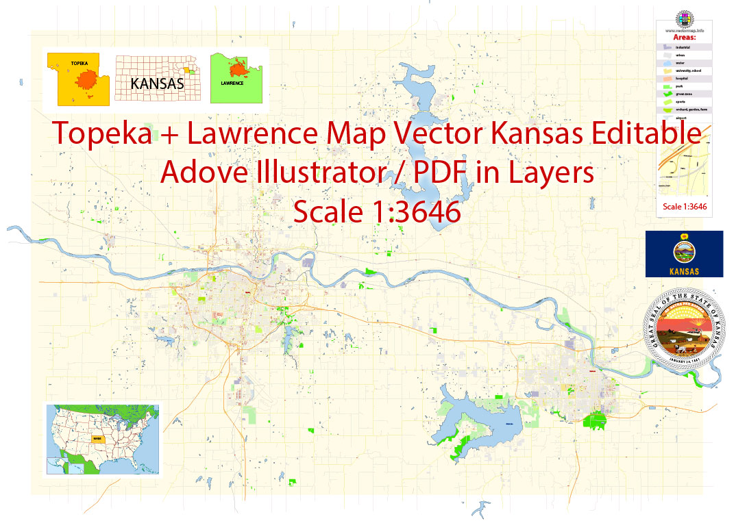
Printable Vector Map of Topeka + Lawrence Kansas US detailed City Plan scale 1:3646 full editable Adobe Illustrator Street Map in layers , scalable, editable text format all names, 14 mb ZIP
All streets names, Main Objects, Principal Buildings. Map for design, printing, arts, projects, presentations, for architects, designers and builders, business, logistics.
Layers: color_fills, streets_roads, labels_roads, names_objects, names_streets, names_places, water, buildings, grids, legend, etc.
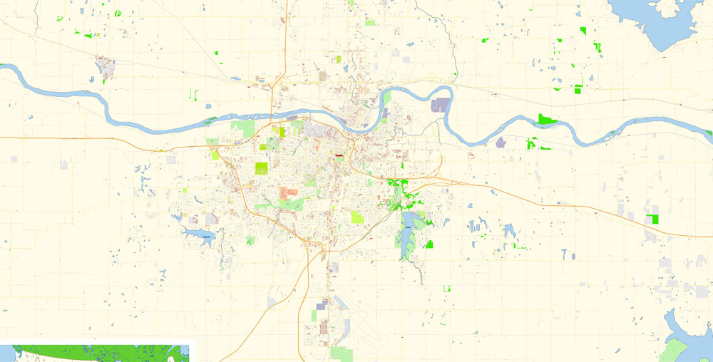
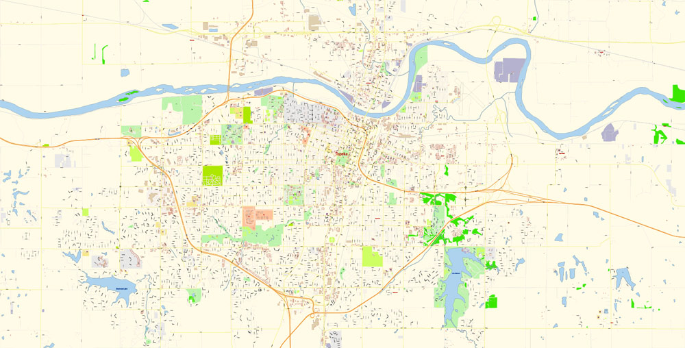
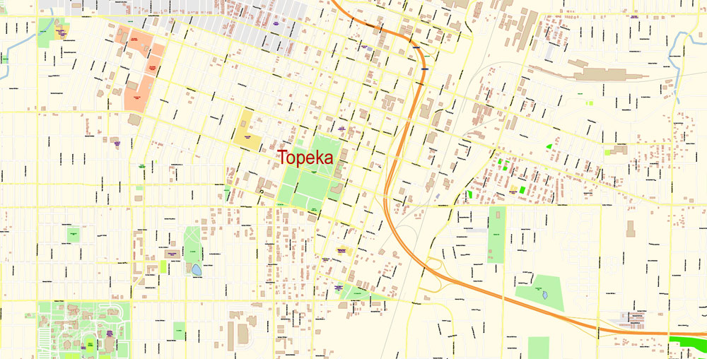
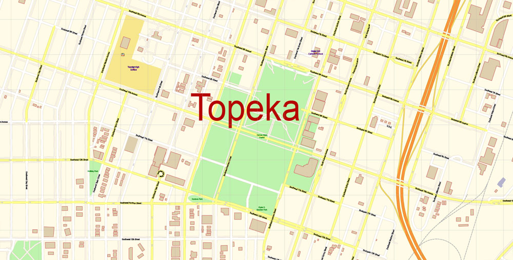
The most exact and detailed map of the city in scale.
For Editing and High Quality Printing
DWG, DXF and other formats – on request, same price, please, contact
Topeka is the capital city of the U.S. state of Kansas and the seat of Shawnee County. It is situated along the Kansas River in the central part of Shawnee County, in northeast Kansas, in the Central United States. As of the 2010 census, the city population was 127,473.
One of the advantages of Lawrence city vector maps of our production is the relevance of cartographic data, we constantly update all our products.
The Topeka Metropolitan Statistical Area, which includes Shawnee, Jackson, Jefferson, Osage, and Wabaunsee counties, had a population of 233,870 in the 2010 census.
If a picture or a map fragment is not selected, and you open the dialog box by clicking the icon in the Control panel, on the Samples palette or in the Color Catalog, the «Edit Colors» dialog box appears and you can only access the «Edit» tab.
Regardless of the name at the top of the dialog box, the right-hand side always displays the color group of the current document, as well as two default color groups: Print Color and Grayscale. These color groups can be selected and used any time.
Create and edit color groups of Lawrence city vector map, and also assign colors using the «Edit Colors»/ а «Repaint Graphic Object» dialog box.
The name Topeka is a Kansa-Osage sentence that means “place where we dug potatoes”, or “a good place to dig potatoes”. As a placename, Topeka was first recorded in 1826 as the Kansa name for what is now called the Kansas River.
Take a look, who purchases our vector maps of Lawrence city in “Our Clients and Friends” page – these are large and small companies, from super-brands like Volvo and Starbucks, to small design studios and printing houses.
Topeka’s founders chose the name in 1855 because it “was novel, of Indian origin and euphonious of sound.” The mixed-blood Kansa Native American, Joseph James, called Jojim, is credited with suggesting the name of Topeka. The city, laid out in 1854, was one of the Free-State towns founded by Eastern antislavery men immediately after the passage of the Kansas–Nebraska Bill. In 1857, Topeka was chartered as a city.
The city is well known for the landmark U.S. Supreme Court case Brown v. Board of Education of Topeka, which overturned Plessy vs. Ferguson and declared racial segregation in public schools to be unconstitutional. Three ships of the U.S. Navy have been named USS Topeka after the city.
Geography
Topeka is at 39°03′N 95°41′W, in north east Kansas at the intersection of I-70 and U.S. Highway 75. It is the origin of I-335 which is a portion of the Kansas Turnpike running from Topeka to Emporia, Kansas. Topeka is also on U.S. Highway 24 (about 50 miles east of Manhattan, Kansas) and U.S. Highway 40 (about 30 miles west of Lawrence, Kansas). U.S.-40 is coincident with I-70 west from Topeka. According to the United States Census Bureau, the city has a total area of 61.47 square miles (159.21 km2), of which, 60.17 square miles (155.84 km2) is land and 1.30 square miles (3.37 km2) is water.
Points of interest
Brown v. Board of Education National Historic Site
Kansas Children’s Discovery Center in Gage Park
Kansas State Capitol, with murals by John Steuart Curry, including the portrait of John Brown towering over “Bleeding Kansas” and the Kansas prairie, and topped with the sculpture of an American Indian named Ad Astra (from the state motto Ad Astra per Aspera, meaning “To the Stars Through Difficulty”.)
Kansas Expocentre and Landon Arena
Combat Air Museum at Forbes Field
Heartland Park Topeka, a major drag racing and road racing course just south of the city.
Kansas Museum of History
Reinisch Rose Garden and Doran Rock Garden, both parts of Gage Park.
Topeka High School
Topeka & Shawnee County Public Library
Topeka Zoo, famous as the birthplace of the first golden eagle chick hatched in captivity and as the first zoo in the nation to have an indoor rain forest.
Old Prairie Town at Ward-Meade Historic Site
Washburn University, the last city-chartered university in the United States.
Westboro Neighborhood
Potwin Neighborhood, originally its own town, Potwin has now been surrounded by the City of Topeka, though it still maintains its own mayor and traditions, including the Easter brunch and 4 July Parade.
Kansas Judicial Center, where both the Supreme Court and Court of Appeals for the state sit.
Cedar Crest, the Kansas Governor’s Mansion on a hilltop overlooking the massive MacLennan Park.
Children’s Discovery Center
Great Overland Station, home of the Kansas Hall of Fame.
The Upstage Gallery
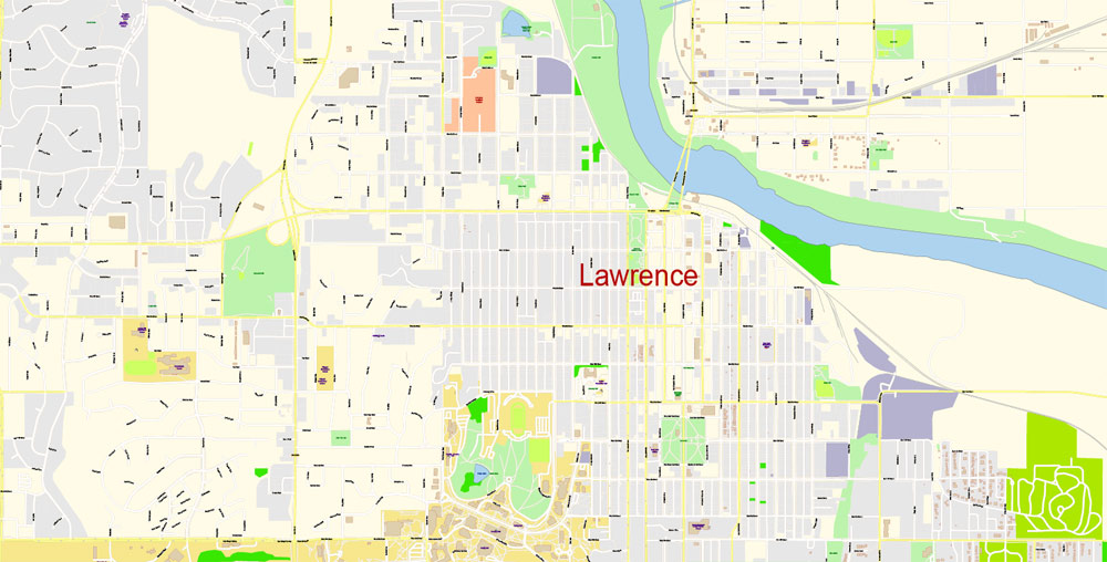
Lawrence is the county seat of Douglas County and sixth largest city in Kansas. It is located in the northeastern sector of the state, next to Interstate 70, between the Kansas and Wakarusa Rivers. As of the 2010 census, the city’s population was 87,643. Lawrence is a college town and the home to both the University of Kansas and Haskell Indian Nations University.
Lawrence was founded by the New England Emigrant Aid Company, and was named for Amos Adams Lawrence, who offered financial aid and support for the settlement. Lawrence was central to the “Bleeding Kansas” period and was the site of the Wakarusa War (1855) and the Sack of Lawrence (1856). During the American Civil War (1861–65), it was also the site of the Lawrence Massacre (1863).
Guides are not limited to vertical and horizontal in Adobe Illustrator. You can also create a diagonal guide for example. Moreover, you can turn any contours into guides. Select the outline and go to View > Guides > Make Guides (Create Guides), or simply press Cmd/Ctrl + 5. You can also turn the guides back into an editable object. Go to menu, View > Guides > Unlock Guides (Release Guides), select the guide you want to edit and select View > Guides > Release Guides (Reset Guides), or just press Cmd/Ctrl + Option / Alt + 5).
Lawrence began as a center of free-state politics. From here, its economy diversified into many industries, including agriculture, manufacturing, and ultimately education, beginning with the founding of the University of Kansas in 1865, and later Haskell Indian Nations University in 1884.
«V» – launches the Selection tool (cursor, black arrow), which makes active any vector line.
«А» – launches the Direct Selection tool (white cursor), allows you to select curve elements and drag them to the desired place.
«R» – activates the Rotate tool, which helps you rotating selected objects around the center point by 360 degrees.
«E» – gives you the opportunity to use the Eraser tool and erase unnecessary parts.
«X» – switches between Fill and Stroke in the Tools section. Try to get used to this hot key and
you will quickly understand that you can’t live and work without it.

Geography
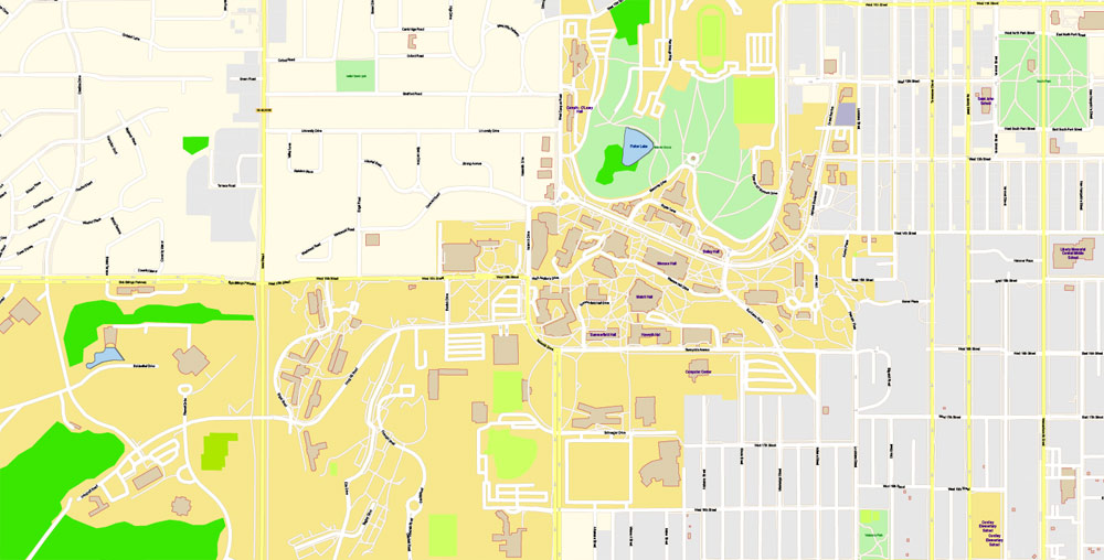
Downtown Lawrence is located at 38°58′18″N 95°14′7″W (38.959902, −95.253199), approximately 25 miles (40 kilometers) east of Topeka, and 35 mi (56 km) west of Kansas City, Kansas. Though Lawrence has a designated elevation of 866 feet (264 m), the highest elevation is Mount Oread on the University of Kansas campus with an elevation of 1,020 feet (310 m). For travelers, maps are sold at the airports and gas stations around the world. Often the source is our vector maps.
The city lies on the southern edge of the Dissected Till Plains, bordering the Osage Plains to the south. According to the United States Census Bureau, the city has a total area of 34.26 square miles (88.73 km2), of which, 33.56 square miles (86.92 km2) is land and 0.70 square miles (1.81 km2) is water, and is split between Wakarusa Township and Grant Township with small portions in Lecompton, Kanwaka and Clinton Townships.
Lawrence is located between the Kansas and Wakarusa Rivers. Several major creeks flow through Lawrence. Burroughs Creek in East Lawrence (named after the writer William S. Burroughs, who retired in East Lawrence) and Baldwin Creek in northwestern Lawrence empty into the Kansas River. Yankee Tank Creek in southwest Lawrence and an unnamed creek that flows through central Lawrence converge with the Wakarusa River south of the city.
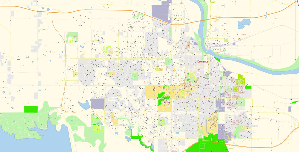
This is the most detailed, exact map of Lawrence city for high-quality printing and polygraphy. You can always clarify the map development date by contacting us.
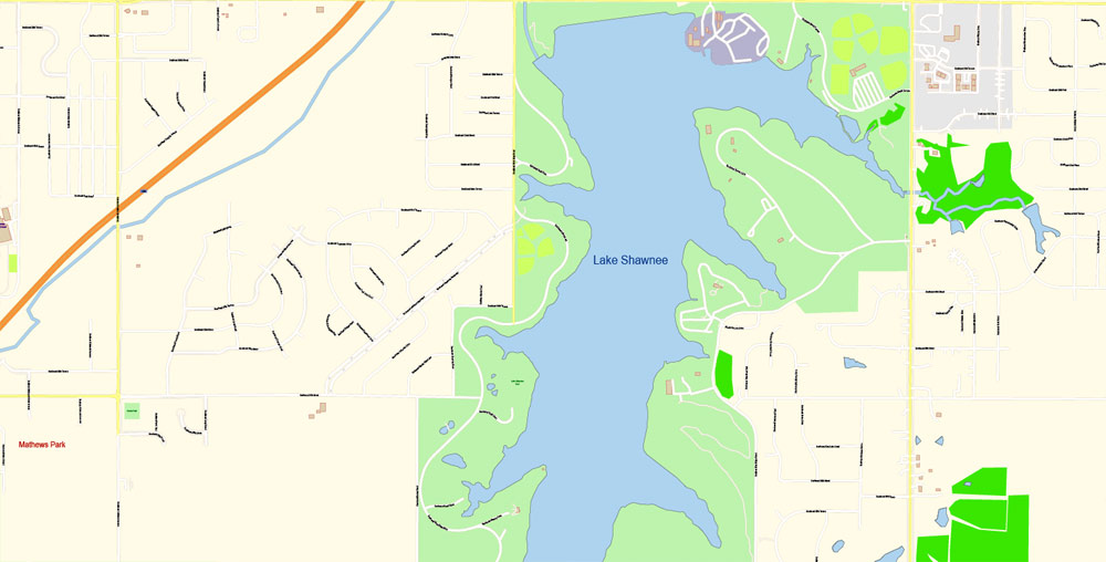
Yankee Tank Creek is dammed to form Lake Alvamar, which was originally called Yankee Tank Lake. The Wakarusa River was dammed to form Clinton Lake. Potter Lake is on the University of Kansas Campus and Mary’s Lake is located in southeastern Lawrence within Prairie Park. The Haskell-Baker Wetlands, maintained by Haskell University and Baker University, is an extensive open space located in the southern part of the city that features wetlands, native plants, hiking and biking trails, and interpretative signage about the prairie and wetland ecosystems.
Lawrence has 54 parks which include community and neighborhood parks, trails, cemeteries and nature preserves. A new, multi-use trail system called the Lawrence Loop (“the Loop”) encircles the city and, when fully completed, will create a 22-mile paved recreational trail, a green transportation network, and multiple opportunities for environmental restoration.
For your convenience, all objects on Lawrence vector city map are divided into layers. And the editing is very easy – colors, lines, etc.
Community parks include South Park, Buford Watson Park, Broken Arrow Park, Riverfront Park, Holcomb Park, “Dad” Perry Park, Centennial Park and Prairie Park. Cemeteries include Oak Hill, Maple Grove and Memorial Park. The first cemetery in Lawrence, Pioneer Cemetery, is on the University of Kansas campus and is maintained by KU. You will probably want to change the color scheme used on our Lawrence vector city map.
But there is more effective way of working with the whole VECTOR MAP of Lawrence city and all layers:
The overview dialog «Edit colors»/«Repaint Graphic Object» (this dialog box name can change depending on the context):
If you have selected a part or a layer of Lawrence city vector map and open the dialog box by clicking the icon in the Control panel, on the Samples palette or the Color Catalog, or if you choose Edit > Edit Colors> Repaint Graphic Object, then the «Repaint Graphic Object» dialog box appears, and you get access to «Assign» and «Edit» tabs.
To quickly and effectively play with colors.
Of course, you can do it manually, all objects in our Lawrence city vector map are divided according to types and layers, and you can easily change the color gamma of vector objects in groups and layers.
Streets
The early settlers of the town named the city’s main road “Massachusetts” to commemorate the New England Emigrant Aid Company’s home state.
The undoubted advantage of Lawrence city vector maps in printing is an excellent and detailed visualization, when customer can expand a large paper map and instantly define his location, find a landmark, an object or address on map, unlike using the popular electronic formats of Google and Yandex maps for example.
Originally, north–south streets were named after states in the order that they were admitted to the Union, and east-west streets were named after famous Revolutionary War heroes. Over the years, however, this plan became marred.
Color groups
Is a list of all saved color groups for current document (the same groups appear in the «Samples» palette). You can edit and delete the existing color groups, as well as creating a new ones using the list of “Color Groups” in the dialog box. All changes appear in the «Samples» palette.
The highlighted color group shows, which color group is currently edited.
Any color group can be selected and edited, or used to redefine the colors in the selected vector map of Lawrence city, its fragments or elements.
A number of streets were placed in the wrong order, North and South Carolina were consolidated into a single Carolina Street near Lawrence High School, and the names of nine states (Alaska, Georgia, Hawaii, Idaho, Nevada, New Mexico, Texas, Washington and Wyoming) were never given to streets. The state street naming system was abandoned with Iowa Street, which runs through the center of Lawrence. In 1913, the east-west streets were renamed to numbered streets.
The specified button is available if the selected vector map or its fragment contains two or more colors.
Note. This color editing method is convenient for global color adjustment in a vector map, if global colors were not used when creating a City Map of Lawrence.
The «Edit colors» button or «Edit or apply colors» on the «Color Catalog» palette
Click this button if you need to edit colors on the «Color Catalog» palette or edit and then apply them to the selected Vector Map of Lawrence city or its fragment.
Neighborhoods
Lawrence is designated by neighborhoods. Neighborhoods closest to downtown are Old West Lawrence, North Lawrence, East Lawrence, Oread, Hancock and Pinckney.
You can easily add any objects needed (e.g. shops, salons, sale points, gas station or attraction) on any layer of Lawrence vector map.
Saving a color group adds this group to the specified list.
Opening the «Edit Colors»/«Repaint Graphic Object» dialog box.
Open the «Edit Colors»/«Repaint Graphic Object» dialog box using one of the following methods:
«Edit»> «Edit Colors»> «Repaint Graphic object» or «Repaint With Style».
Use these commands if you need to edit the colors in the selected vector map of Lawrence city.
«Repaint Graphic object» button on the «Control» panel.
Use this button if you need to adjust colors of Lawrence city vector map using the а «Repaint graphic object» dialog box.
The neighborhoods west of Iowa Street are Sunset Hills, Prairie Meadows, Deerfield, and Alvamar. There are several neighborhoods listed on the National Register of Historic Places: Old West Lawrence, Oread, Hancock, Breezedale, and most of Rhode Island Street in East Lawrence.
This vector map of Lawrence city is used as a basis for design, editing, and further printing.
North Lawrence
Grant Township, north of the Kansas River, was annexed to Douglas County in 1870 from southern Sarcoxie Township in Jefferson County. The largest city in the township was Jefferson, founded in 1866 just over the river from Lawrence.
The Lawrence city map in vector format is used for design, urban planning, presentations and media visualizations.
The advertising and presentation map of Lawrence city (usually the final designer marks the routes, and puts the client’s objects (shops, saloons, gas stations etc.)
The undoubted advantage is that people will NEVER throw out this advertising product – the map. In fact, as an advertising medium, a city map is the most “long-playing” of the well-known polygraphic advertising media, with the longest lifespan, and the maximum number of interactions with the customer.
Jefferson was renamed North Lawrence in 1869 and it was attempted to annex the town to Lawrence proper but the motion failed.
This vector map of Lawrence city is used by:
designers, layout designers, printers, advertisers and architects. Our product – vector maps – is designed for further editing and printing in large formats – from @Wall format (a few meters) to A-0 and A-1, A-2, A-3.
A. Creating and editing of a color group on the «Edit» tab
B. Assigning colors on the «Assign» tab
C. Select a group of colors from the «Color groups» list
The option «Repaint a graphic object» in the lower part of the dialog box allows you to preview the colors on a selected layer of Vector map, or a group of elements, and specify whether its colors will be redefined when the dialog box is closed.
The main areas of the dialog box are:
«Edit»
The «Edit» tab is designed to create a new or edit the existing color groups.
The harmony rules Menu and the Color Wheel are used to conduct experiments with color harmonies. The color wheel shows how colors are related in color harmony, and the color bars allow you to view and manipulate an individual color values. In addition, you can adjust the brightness, add and remove colors, save color groups and view colors on the selected Vector Map of Lawrence city or a separated layers.
The following year, the State Legislature annexed the town.
Assign
The «Assign» tab is used to view and control on how the original colors are replaced with colors from the color group like your corporate colors in the Vector Map of Lawrence city.
The assign color ability is provided only if the entire map, layer or fragment is selected in the document. You can specify which of new colors replace the current colors, whether the spot colors should be preserved and how colors are replaced (for example, you can replace colors completely or changing the color tone while maintaining the brightness). The «Assign» tab allows you to redefine colors in the Vector Map of Lawrence city, or in separate layers and fragments using the current color group or reducing the number of colors in the current Vector Map.
Just northeast of North Lawrence there once was a popular park area known as Bismarck Grove. During the late 19th century, this area housed numerous fairs, picnics, and temperance meetings. In 1870, the Kansas Pacific railroad set up a number of manufacturing and repair shops in this area, which became known as “Bismarck”.
Printable vector maps of Lawrence city are much more convenient and efficient than any electronic maps on your smartphone, because ALL DETAILS are displayed in the entire space of Lawrence city map.
Useful tips on working with vector maps of cities and countries in Adobe Illustrator.
It’s very easy to work with vector maps of Lawrence city, even for a not very experienced designer who can turn on and off the map layers, add new objects, change the colors of fill and lines according to customer requirements.
The first organized gathering in the area took play in 1878 was the National Temperance camp meeting. The last fair was held at the Grove in 1899, and due to financial issues, the area was sold and became private property in 1900.
The «Edit color group» button or «Edit or apply color group» on the «Samples» palette.
Click this button if you need to edit the colors in the specific color group or edit and apply them to the selected Vector Map of Lawrence city or a group of its elements, for example, the whole layer “Streets and lines”. You can also double-click the color group in the Samples panel to open the dialog box.
If the map file is too large and your computer freezes or even can’t open it quickly:
1. Try to reduce the color resolution of the video card (display) to 256 colors while working with a large map.
2. Using Windows Task Manager, select all the application you don’t need, while working with map, just turn them off.
3. Launch Adobe Illustrator. (DO NOT OPEN the vector map file)
4. Start the Windows Task Manager using administrator rights > Find the “Illustrator” process > set the «real time» priority,
5. Open the file. When you see the LEGACY FONT popup window – click “OK” (do not update). You can restore the TEXT later.
6. Can also be useful: When file is opened – Edit > Settings > Basic Settings > disable smoothing. /// It looks scary, but works quickly)))
We recommend saving the file in Adobe Illustrator 10 version. It’s much more stable when working with VERY BIG size files.
Topeka
City in Kansas
Topeka is the capital city of Kansas. The domed, neoclassical State Capitol has murals and statues. Photos and exhibits at the Brown v. Board of Education National Historic Site commemorate the 1954 Supreme Court decision to end racial segregation in schools. The Kansas Museum of History features an 1880s locomotive. Old Prairie Town at Ward-Meade Historic Site has a mansion, 1890s schoolhouse and botanical garden.
Area
• State capital and city 61.47 sq mi (159.21 km2)
• Land 60.17 sq mi (155.84 km2)
• Water 1.30 sq mi (3.37 km2)
Elevation 945 ft (288 m)
Population
• State capital and city 127,473
• Estimate 126,808
• Rank US: 215th
• Density 2,100/sq mi (800/km2)
• Urban 150,003 (US: 217th)
• Metro 233,791 (US: 193rd)
Lawrence
City in Kansas
Lawrence is a city in northeast Kansas. On the University of Kansas campus, the Spencer Museum of Art has a large collection of contemporary and indigenous art. The KU Natural History Museum has dinosaur fossils, live insects and a honeybee colony. South, sprawling Baker Wetlands is home to hundreds of bird species. West of the city, trail-lined Clinton State Park has deer, plus bass and catfish in Clinton Lake.
Area
• Total 34.26 sq mi (88.7 km2)
• Land 33.56 sq mi (86.9 km2)
• Water 0.70 sq mi (1.8 km2)
Elevation 866 ft (264 m)
Population
• Total 87,643
• Estimate 95,358
• Density 2,600/sq mi (990/km2)
Free US vector maps

Free Download Vector Map US County and State Adobe Illustrator
Free_Vector_Map_US_States_County_Map.ai
Free Download Vector Map US County and State Adobe PDF
Free_Vector_Map_US_States_County_Map.pdf

Free Download Vector Map US With States Names, Adobe Illustrator
Free_Map_of_USA_with_state_names_en.ai
Free Download Vector Map US With States Names, Adobe PDF
Free_Map_of_USA_with_state_names_en.pdf
From WIKI
Free vector map World, Adobe Illustrator, download now maps vector clipart
Map for design, projects, presentation free to use as you like.
See also: TERMS & CONDITIONS: SOFTWARE LICENSE AGREEMENT FOR DIGITAL CARTOGRAPHIC DATA.
Need more USA Vector Maps, printable and editable?

 Author: Kirill Shrayber, Ph.D. FRGS

 full editable, Adobe Illustrator")
