Springfield PDF Vector Map large area Massachusetts US Extra detailed City Plan editable Adobe PDF Street Map

  1. Home
  2. North America maps
  3. United States vector maps cities, states and country: PDF and Adobe Illustrator
  4. Springfield PDF Vector Map large area Massachusetts US Extra detailed City Plan editable Adobe PDF Street Map

WhatsApp us! If you have any questions, please, feel free to contact us via WhatsApp +1.829.4100078

We accept PayPal and all  Debit or Credit Cards | Instantly Download Your Map after payment.
Verified Seller 10+ years.

$ 57.00

Printable PDF Vector Map of Springfield large area MA US Extra detailed City Plan scale 1:3479 full editable Adobe PDF Street Map in layers , scalable, editable text format  all names, 33 mb ZIP
All streets names, Main Objects, All Buildings. Map for design, printing, arts, projects, presentations, for architects, designers and builders, business, logistics.  
Layers: color_fills,  streets_roads, labels_roads, names_objects, names_streets, names_places, water, buildings, grids, legend, etc.
The most exact and detailed map of the city in scale.
Map cover area: Springfield, Holyoke, Chicopee, West Springfield, South Hadley, Hadley, East Hampton, Amherst and Northampton
For Editing and High Quality Printing

SKU: 2018.03.10.SF.LA.MA.US.GVL17B.PDF
Share this map for your friends!

Taxonomy: Product Tags for this Vector Map

AutoCAD Map Springfield Massachusetts US, City Map Springfield Massachusetts US, City Plan Springfield Massachusetts US, CorelDraw Map Springfield Massachusetts US, DWG Map Springfield Massachusetts US, DXF Map Springfield Massachusetts US, Editable Map Springfield Massachusetts US, Illustrator Map Springfield Massachusetts US, Map Springfield Massachusetts US for Printing, Map Springfield Massachusetts US: Editable Vector PDF and Adobe Illustrator, MASSACHUSETTS MA STATE: Vector Maps in PDF and Adobe Illustrator, printable map Springfield Massachusetts US, Road Map Springfield Massachusetts US, Springfield Massachusetts US City Vector Map, Springfield Massachusetts US Map, Street Map Springfield Massachusetts US, Tourist Map Springfield Massachusetts US, Urban Plan Springfield Massachusetts US, Vector Map Springfield Massachusetts US

Map Categories

North America maps, United States vector maps cities, states and country: PDF and Adobe Illustrator

Extended Description of the Vector Map

Printable PDF Vector Map of Springfield large area MA US Extra detailed City Plan scale 1:3479 full editable Adobe PDF Street Map in layers , scalable, editable text format  all names, 33 mb ZIP
All streets names, Main Objects, All Buildings. Map for design, printing, arts, projects, presentations, for architects, designers and builders, business, logistics.  
Layers: color_fills,  streets_roads, labels_roads, names_objects, names_streets, names_places, water, buildings, grids, legend, etc.
The most exact and detailed map of the city in scale.
Map cover area: Springfield, Holyoke, Chicopee, West Springfield, South Hadley, Hadley, East Hampton, Amherst and Northampton
For Editing and High Quality Printing
DWG, DXF and other formats – on request, same price, please, contact

Springfield
City in Massachusetts
Springfield is a city in western Massachusetts. Beside the Connecticut River, Naismith Memorial Basketball Hall of Fame commemorates the sport in a striking building. Collections at the Springfield Museums include American paintings and sculpture, scientific exhibits and Asian art. The Amazing World of Dr. Seuss celebrates the beloved children’s author. Springfield Armory documents 2 centuries of military history.

Area
• City 33.1 sq mi (85.7 km2)
• Land 31.9 sq mi (82.5 km2)
• Water 1.2 sq mi (3.1 km2)
Elevation 70 ft (21 m)
Population
• City 153,060
• Estimate 154,758
• Rank 165th, U.S. as of 2017 incorporated places estimate
• Density 4,803/sq mi (1,854.6/km2)
• Metro 692,942

Map cover area

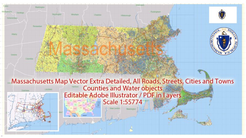
See Also: Extra detailed map Full Massachusetts State:

Printable Vector Map Massachusetts State US, exact extra detailed All Roads, Cities and Counties map editable Layered Adobe Illustrator

Free US vector maps

Free Download Vector Map US County and State Adobe Illustrator Free_Vector_Map_US_States_County_Map.ai Free Download Vector Map US County and State Adobe PDF Free_Vector_Map_US_States_County_Map.pdf
Free Download Vector Map US County and State Adobe Illustrator
Free_Vector_Map_US_States_County_Map.ai
Free Download Vector Map US County and State Adobe PDF
Free_Vector_Map_US_States_County_Map.pdf

Free Dowmload Vector Map US With States Names, Adobe Illustrator Free_Map_of_USA_with_state_names_en.ai Free Dowmload Vector Map US With States Names, Adobe PDF Free_Map_of_USA_with_state_names_en.pdf
Free Download Vector Map US With States Names, Adobe Illustrator
Free_Map_of_USA_with_state_names_en.ai

Free Download Vector Map US With States Names, Adobe PDF
Free_Map_of_USA_with_state_names_en.pdf 

From WIKI

Free vector map World, Adobe Illustrator, download now maps vector clipart
Map for design, projects, presentation free to use as you like.

See also: TERMS & CONDITIONS: SOFTWARE LICENSE AGREEMENT FOR DIGITAL CARTOGRAPHIC DATA.

Need more USA Vector Maps, printable and editable?

Author: Kirill Shrayber, Ph.D.

I have been working with vector cartography for over 25 years, including GPS, GIS, Adobe Illustrator and other professional cartographic software.
Linkedin: https://www.linkedin.com/in/kirill-shrayber-0b839325/
Twitter: https://twitter.com/vectormapper

See more maps of this city / area / state / country

Menu