Printable Vector Map of Severna Park + Annapolis Maryland US detailed City Plan scale 1:3648 full editable Adobe Illustrator Street Map in layers , scalable, text format all names, 21 mb ZIP
All streets names, Main Objects, Buildings. Map for design, printing, arts, projects, presentations, for architects, designers and builders, business, logistics.
Layers: color_fills, water, streets_roads, labels_roads, names_objects, names_streets, names_places, water, buildings, grids, legend, etc.
The most exact and detailed map of the city in scale.
For Editing and High Quality Printing
DWG, DXF and other formats – on request, same price, please, contact
Map coverage area
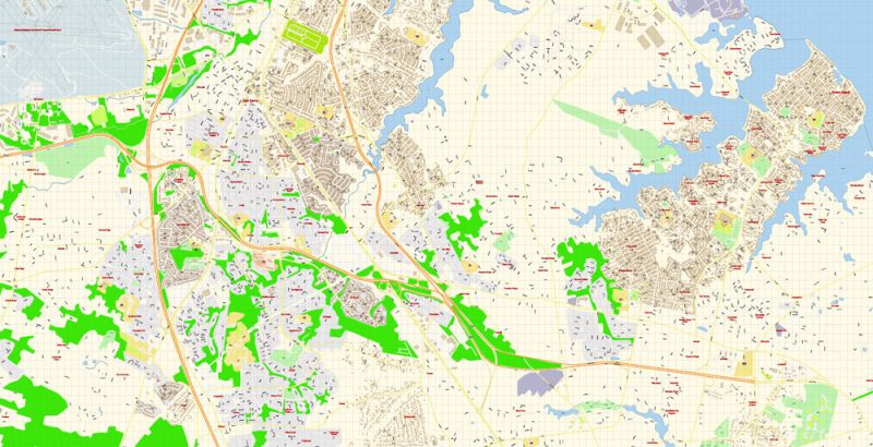
This vector map of Severna Park city is used as a basis for design, editing, and further printing.
This is the most detailed, exact map of Severna Park city for high-quality printing and polygraphy. You can always clarify the map development date by contacting us.
For your convenience, all objects on Severna Park vector city map are divided into layers, and the editing is very easy – colors, lines, etc.
You can easily add any objects needed (e.g. shops, salons, sale points, gas station or attraction) on any layer of Severna Park vector map.
One of the advantages of Severna Park city vector maps of our production is the relevance of cartographic data, we constantly update all our products.
Severna Park is a census-designated place (CDP) in Anne Arundel County, Maryland, United States. Severna Park is part of the Baltimore-Washington Metropolitan Area, and is located approximately 8 miles (13 km) north of Annapolis, 17 miles (27 km) south of Baltimore, and 39 miles (63 km) east of Washington, D.C. Severna Park’s population was 37,634 at the 2010 census.
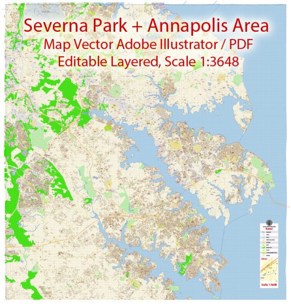
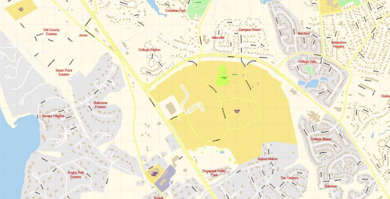
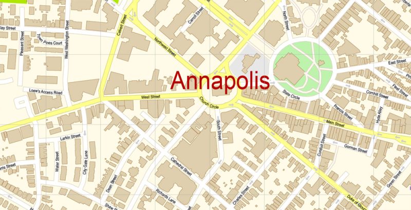
Vector Map Severna Park + Annapolis Maryland Exact City Plan detailed Street Map Adobe Illustrator overview
This vector map of Severna Park city is used by:
designers, layout designers, printers, advertisers and architects. Our product – vector maps – is designed for further editing and printing in large formats – from @Wall format (a few meters) to A-0 and A-1, A-2, A-3.
The Severna Park city map in vector format is used for design, urban planning, presentations and media visualizations.
The name Severna Park is believed to originate from a 1906 contest held by Oscar Hatton while the modern community was first becoming established. The winner would receive a portion of land but controversy arose because the winner was an African-American woman, who was instead rewarded $500.
The advertising and presentation map of Severna Park city (usually the final designer marks the routes, and puts the client’s objects (shops, saloons, gas stations etc.)
The undoubted advantage is that people will NEVER throw out this advertising product – the map. In fact, as an advertising medium, a city map is the most “long-playing” of the well-known polygraphic advertising media, with the longest lifespan, and the maximum number of interactions with the customer.
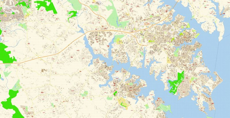
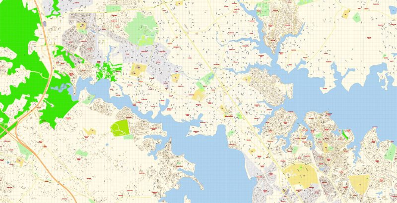
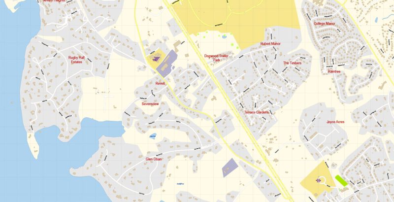
Vector Map Severna Park + Annapolis Maryland Exact City Plan detailed Street Map Adobe Illustrator preview 1
For travelers, maps are sold at the airports amd gas stations around the world. Often the source is our vector maps.
Robinson House was listed on the National Register of Historic Places in 2009. Severna Park was originally named “Boone,” and was a stop along the Baltimore & Annapolis Railroad, which was converted to the B&A Rail Trail in 1990. Severna Park is also home to the Severn School, which was established in 1914, as well as several other old homes and buildings.
Take a look, who purchases our vector maps of Severna Park city in “Our Clients and Friends” page – these are large and small companies, from super-brands like Volvo and Starbucks, to small design studios and printing houses.
It’s very easy to work with vector maps of Severna Park city, even for a not very experienced designer who can turn on and off the map layers, add new objects, change the colors of fill and lines according to customer requirements.
The undoubted advantage of Severna Park city vector maps in printing is an excellent and detailed visualization, when customer can expand a large paper map and instantly define his location, find a landmark, an object or address on map, unlike using the popular electronic formats of Google and Yandex maps for example.
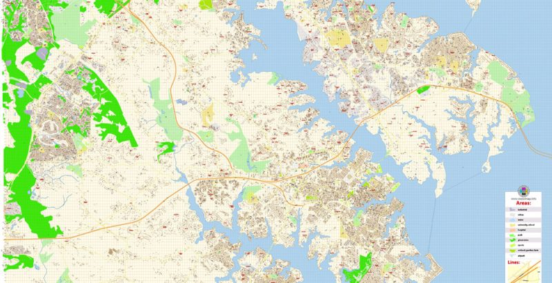
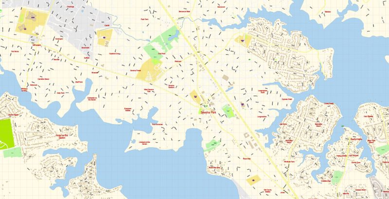
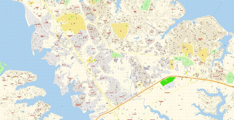
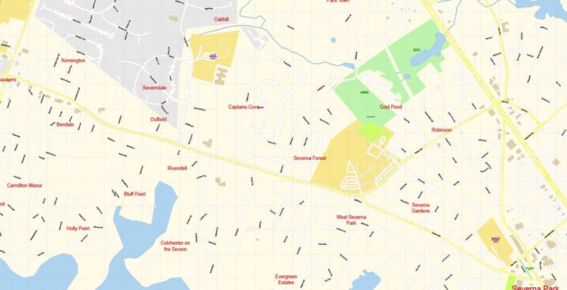
Vector Map Severna Park + Annapolis Maryland Exact City Plan detailed Street Map Adobe Illustrator preview 2
In many Slavic languages, Severna means “northern”.
Geography and transportation
Severna Park is located at 39°4′56″N 76°33′56″W (39.082109, −76.565656), between the eastern shore of the Severn River and northwestern shore of the Magothy River, approximately 17 miles (27 km) south of Baltimore and 39 miles (63 km) east of Washington, D.C. It is bordered to the north by Pasadena, to the east (across the Magothy River) by Lake Shore, to the southeast by Arnold, to the southwest (across the Severn River) by Herald Harbor and Arden on the Severn, and to the west by Gambrills and Millersville.
Take a look, who purchases our vector maps of Severna Park city in “Our Clients and Friends” page – these are large and small companies, from super-brands like Volvo and Starbucks, to small design studios and printing houses.
It’s very easy to work with vector maps of Severna Park city, even for a not very experienced designer who can turn on and off the map layers, add new objects, change the colors of fill and lines according to customer requirements.
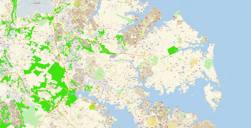
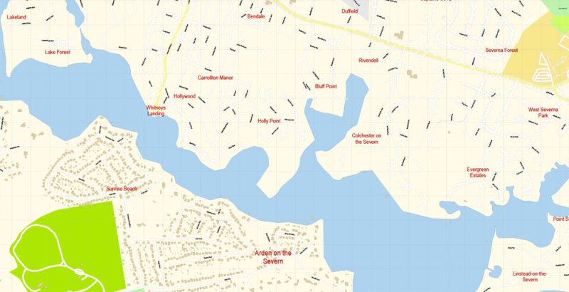
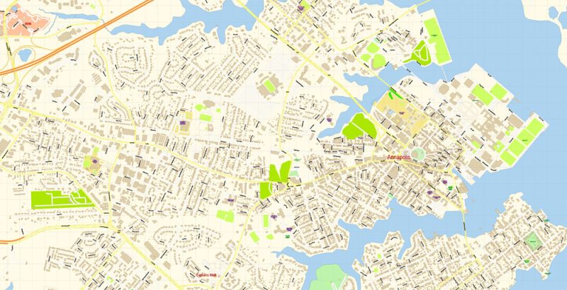
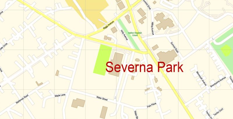
Vector Map Severna Park + Annapolis Maryland Exact City Plan detailed Street Map Adobe Illustrator preview 3
The undoubted advantage of Severna Park city vector maps in printing is an excellent and detailed visualization, when customer can expand a large paper map and instantly define his location, find a landmark, an object or address on map, unlike using the popular electronic formats of Google and Yandex maps for example.
Printable vector maps of Severna Park city is much more convenient and efficient than any electronic maps on your smartphone, because ALL DETAILS are displayed in the entire space of Severna Park city map.
Severna Park is split by Ritchie Highway (Maryland Route 2), which runs between Baltimore and Annapolis and directly through Severna Park, serving as one of the main thoroughfares in the area. Other main roads include Benfield Road and Baltimore-Annapolis Boulevard (Maryland Route 648). Interstate 97 runs from Annapolis to Baltimore directly west of Severna Park, passing through Millersville. Severna Park is accessible from I-97 via exit 10 to Benfield Boulevard/Veterans Highway.
Useful tips on working with vector maps of cities and countries in Adobe Illustrator.
«V» – launches the Selection tool (cursor, black arrow), which makes active any vector line.
«А» – launches the Direct Selection tool (white cursor), allows you to select curve elements and drag them to the desired place.
«R» – activates the Rotate tool, which helps you rotating selected objects around the center point by 360 degrees.
«E» – gives you the opportunity to use the Eraser tool and erase unnecessary parts.
«X» – switches between Fill and Stroke in the Tools section. Try to get used to this hot key and
you will quickly understand that you can’t live and work without it.
Vector Map Severna Park + Annapolis Maryland Exact City Plan detailed Street Map Adobe Illustrator preview 4
Severna Park is served by the Maryland Transit Administration’s Route 70. A large portion of the Baltimore & Annapolis Trail also runs through Severna Park. The trail, which is now a bike trail, was originally a rail trail before being converted as part of the East Coast Greenway in 1996. The trail’s headquarters are located on Earleigh Heights Road in Severna Park.
Guides are not limited to vertical and horizontal in Adobe Illustrator. You can also create a diagonal guide for example. Moreover, you can turn any contours into guides. Select the outline and go to View > Guides > Make Guides (Create Guides), or simply press Cmd/Ctrl + 5. You can also turn the guides back into an editable object. Go to menu, View > Guides > Unlock Guides (Release Guides), select the guide you want to edit and select View > Guides > Release Guides (Reset Guides), or just press Cmd/Ctrl + Option / Alt + 5).
According to the United States Census Bureau, Severna Park has a total area of 19.3 square miles (50.1 km2), of which 16.5 square miles (42.7 km2) is land and 2.9 square miles (7.4 km2), or 14.76%, is water.
You will probably want to change the color scheme used on our Severna Park vector city map.
To quickly and effectively play with colors.
Of course, you can do it manually, all objects in our Severna Park city vector map are divided according to types and layers, and you can easily change the color gamma of vector objects in groups and layers.
But there is more effective way of working with the whole VECTOR MAP of Severna Park city and all layers:
The overview dialog «Edit colors»/«Repaint Graphic Object» (this dialog box name can change depending on the context):
If you have selected a part or a layer of Severna Park city vector map and open the dialog box by clicking the icon in the Control panel, on the Samples palette or the Color Catalog, or if you choose Edit > Edit Colors> Repaint Graphic Object, then the «Repaint Graphic Object» dialog box appears, and you get access to «Assign» and «Edit» tabs.
Vector Map Severna Park + Annapolis Maryland Exact City Plan detailed Street Map Adobe Illustrator preview 5
If a picture or a map fragment is not selected, and you open the dialog box by clicking the icon in the Control panel, on the Samples palette or in the Color Catalog, the «Edit Colors» dialog box appears and you can only access the «Edit» tab.
Regardless of the name at the top of the dialog box, the right-hand side always displays the color group of the current document, as well as two default color groups: Print Color and Grayscale. These color groups can be selected and used any time.
Create and edit color groups of Severna Park city vector map, and also assign colors using the «Edit Colors»/ а «Repaint Graphic Object» dialog box.
A. Creating and editing of a color group on the «Edit» tab
B. Assigning colors on the «Assign» tab
C. Select a group of colors from the «Color groups» list
The option «Repaint a graphic object» in the lower part of the dialog box allows you to preview the colors on a selected layer of Vector map, or a group of elements, and specify whether its colors will be redefined when the dialog box is closed.
The main areas of the dialog box are:
«Edit»
The «Edit» tab is designed to create a new or edit the existing color groups.
The harmony rules Menu and the Color Wheel are used to conduct experiments with color harmonies. The color wheel shows how colors are related in color harmony, and the color bars allow you to view and manipulate an individual color values. In addition, you can adjust the brightness, add and remove colors, save color groups and view colors on the selected Vector Map of Severna Park city or a separated layers.
Assign
The «Assign» tab is used to view and control on how the original colors are replaced with colors from the color group like your corporate colors in the Vector Map of Severna Park city.
The assign color ability is provided only if the entire map, layer or fragment is selected in the document. You can specify which of new colors replace the current colors, whether the spot colors should be preserved and how colors are replaced (for example, you can replace colors completely or changing the color tone while maintaining the brightness). The «Assign» tab allows you to redefine colors in the Vector Map of Severna Park city, or in separate layers and fragments using the current color group or reducing the number of colors in the current Vector Map.
Vector Map Severna Park + Annapolis Maryland Exact City Plan detailed Street Map Adobe Illustrator preview 6
Color groups
Is a list of all saved color groups for current document (the same groups appear in the «Samples» palette). You can edit and delete the existing color groups, as well as creating a new ones using the list of “Color Groups” in the dialog box. All changes appear in the «Samples» palette.
The highlighted color group shows, which color group is currently edited. Any color group can be selected and edited, or used to redefine the colors in the selected vector map of Severna Park city, its fragments or elements.
Saving a color group adds this group to the specified list.
Opening the «Edit Colors»/«Repaint Graphic Object» dialog box.
Open the «Edit Colors»/«Repaint Graphic Object» dialog box using one of the following methods:
«Edit»> «Edit Colors»> «Repaint Graphic object» or «Repaint With Style».
Use these commands if you need to edit the colors in the selected vector map of Severna Park city.
«Repaint Graphic object» button on the «Control» panel.
Use this button if you need to adjust colors of Severna Park city vector map using the а «Repaint graphic object» dialog box.
The specified button is available if the selected vector map or its fragment contains two or more colors.
Note. This color editing method is convenient for global color adjustment in a vector map, if global colors were not used when creating a City Map of Severna Park.
Vector Map Severna Park + Annapolis Maryland Exact City Plan detailed Street Map Adobe Illustrator preview 7
The «Edit colors» button or «Edit or apply colors» on the «Color Catalog» palette
Click this button if you need to edit colors on the «Color Catalog» palette or edit and then apply them to the selected Vector Map of Severna Park city or its fragment.
The «Edit color group» button or «Edit or apply color group» on the «Samples» palette.
Click this button if you need to edit the colors in the specific color group or edit and apply them to the selected Vector Map of Severna Park city or a group of its elements, for example, the whole layer “Streets and lines”. You can also double-click the color group in the Samples panel to open the dialog box.

Vector Map Severna Park + Annapolis Maryland Exact City Plan detailed Street Map Adobe Illustrator preview 8
If the map file is too large and your computer freezes or even can’t open it quickly:
1. Try to reduce the color resolution of the video card (display) to 256 colors while working with a large map.
2. Using Windows Task Manager, select all the application you don’t need, while working with map, just turn them off.
3. Launch Adobe Illustrator. (DO NOT OPEN the vector map file)
4. Start the Windows Task Manager using administrator rights > Find the “Illustrator” process > set the «real time» priority,
5. Open the file. When you see the LEGACY FONT popup window – click “OK” (do not update). You can restore the TEXT later.
6. ???? Can also be useful: ???? When the file is opened – Edit > Settings > Basic Settings > disable smoothing. /// It looks scary, but works quickly)))
We recommend saving the file in Adobe Illustrator 10 version. It’s much more stable when working with VERY BIG size files.
Vector Map Severna Park + Annapolis Maryland Exact City Plan detailed Street Map Adobe Illustrator preview 9
Vector Map Severna Park + Annapolis Maryland Exact City Plan detailed Street Map Adobe Illustrator preview 10
Vector Map Severna Park + Annapolis Maryland Exact City Plan detailed Street Map Adobe Illustrator preview 11
Vector Map Severna Park + Annapolis Maryland Exact City Plan detailed Street Map Adobe Illustrator preview 12
Vector Map Severna Park + Annapolis Maryland Exact City Plan detailed Street Map Adobe Illustrator preview 13
Vector Map Severna Park + Annapolis Maryland Exact City Plan detailed Street Map Adobe Illustrator preview 14
Vector Map Severna Park + Annapolis Maryland Exact City Plan detailed Street Map Adobe Illustrator preview 15
Free US vector maps

Free Download Vector Map US County and State Adobe Illustrator
Free_Vector_Map_US_States_County_Map.ai
Free Download Vector Map US County and State Adobe PDF
Free_Vector_Map_US_States_County_Map.pdf

Free Download Vector Map US With States Names, Adobe Illustrator
Free_Map_of_USA_with_state_names_en.ai
Free Download Vector Map US With States Names, Adobe PDF
Free_Map_of_USA_with_state_names_en.pdf
From WIKI
Free vector map World, Adobe Illustrator, download now maps vector clipart
Map for design, projects, presentation free to use as you like.
See also: TERMS & CONDITIONS: SOFTWARE LICENSE AGREEMENT FOR DIGITAL CARTOGRAPHIC DATA.
Need more USA Vector Maps, printable and editable?


 Author: Kirill Shrayber, Ph.D. FRGS


 Street Map editable Adobe Illustrator in layers")