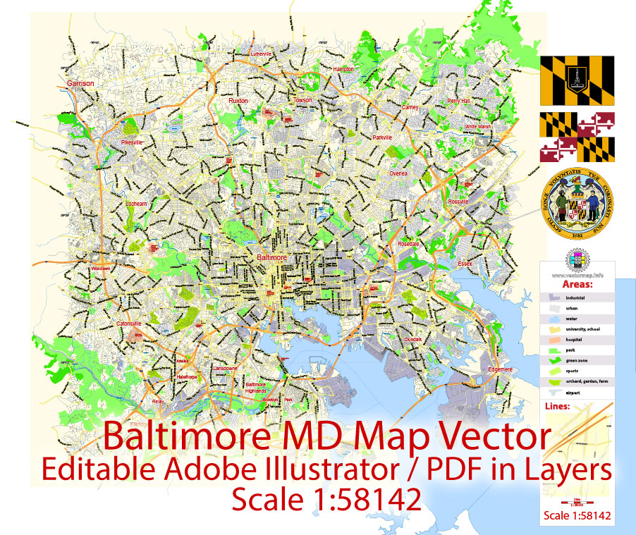
Printable Vector PDF Map Baltimore Maryland US, exact City Plan scale 1:58142 full editable Adobe PDF Street Map in layers, scalable, editable text format street names, 14 mb ZIP
Principal streets names, Main Objects. Map for design, printing, arts, projects, presentations, for architects, designers and builders, business, logistics.
Layers: color_fills, streets_roads, labels_roads, names_objects, names_streets, names_places, grids, halo 1-2, water objects, legend.
The most exact and detailed map of the city in scale.
For High Quality Printing Large or Small format.
DWG, DXF and other formats – on request, same price, please, contact
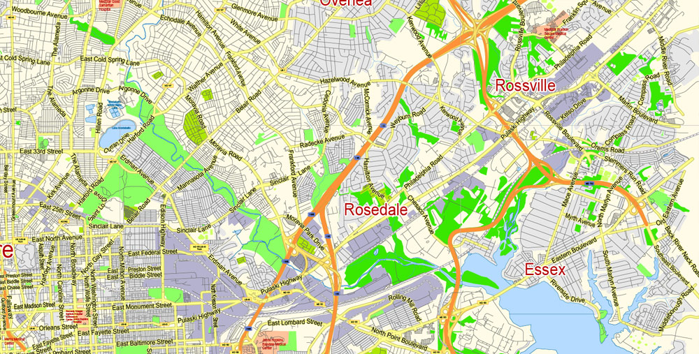
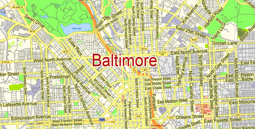
Baltimore, Maryland, USA.
This vector map of Baltimore city is used as a basis for design, editing, and further printing.
This is the most detailed, exact map of Baltimore city for high-quality printing and polygraphy. You can always clarify the map development date by contacting us.
For your convenience, all objects on Baltimore vector city map are divided into layers. And the editing is very easy – colors, lines, etc.
You can easily add any objects needed (e.g. shops, salons, sale points, gas station or attraction) on any layer of Baltimore vector map.
Baltimore is the largest city in the U.S. state of Maryland, and the 30th-most populous city in the United States.
One of the advantages of Baltimore city vector maps of our production is the relevance of cartographic data, we constantly update all our products.
This vector map of Baltimore city is used by:
designers, layout designers, printers, advertisers and architects. Our product – vector maps – is designed for further editing and printing in large formats – from @Wall format (a few meters) to A-0 and A-1, A-2, A-3.
The Baltimore city map in vector format is used for design, urban planning, presentations and media visualizations.
The advertising and presentation map of Baltimore city (usually the final designer marks the routes, and puts the client’s objects (shops, saloons, gas stations etc.)
The undoubted advantage is that people will NEVER throw out this advertising product – the map. In fact, as an advertising medium, a city map is the most “long-playing” of the well-known polygraphic advertising media, with the longest lifespan, and the maximum number of interactions with the customer.
Baltimore was established by the Constitution of Maryland and is an independent city that is not part of any county. With a population of 611,648 in 2017, Baltimore is the largest independent city in the United States. As of 2017, the population of the Baltimore metropolitan area was estimated to be just under 2.808 million, making it the 20th largest metropolitan area in the country. Baltimore is located about 40 miles (60 km) northeast of Washington, D.C., making it a principal city in the Washington-Baltimore combined statistical area (CSA), the fourth-largest CSA in the nation, with a calculated 2017 population of 9,764,315.
For travelers, maps are sold at the airports and gas stations around the world. Often the source is our vector maps.
Take a look, who purchases our vector maps of Baltimore city in “Our Clients and Friends” page – these are large and small companies, from super-brands like Volvo and Starbucks, to small design studios and printing houses.
It’s very easy to work with vector maps of Baltimore city, even for a not very experienced designer who can turn on and off the map layers, add new objects, change the colors of fill and lines according to customer requirements.
The undoubted advantage of Baltimore city vector maps in printing is an excellent and detailed visualization, when customer can expand a large paper map and instantly define his location, find a landmark, an object or address on map, unlike using the popular electronic formats of Google and Yandex maps for example.
Printable vector maps of Baltimore city are much more convenient and efficient than any electronic maps on your smartphone, because ALL DETAILS are displayed in the entire space of Baltimore city map.
Useful tips on working with vector maps of cities and countries in Adobe Illustrator.
«V» – launches the Selection tool (cursor, black arrow), which makes active any vector line.
«А» – launches the Direct Selection tool (white cursor), allows you to select curve elements and drag them to the desired place.
«R» – activates the Rotate tool, which helps you rotating selected objects around the center point by 360 degrees.
«E» – gives you the opportunity to use the Eraser tool and erase unnecessary parts.
«X» – switches between Fill and Stroke in the Tools section. Try to get used to this hot key and
you will quickly understand that you can’t live and work without it.
Founded in 1729, Baltimore is the second-largest seaport in the Mid-Atlantic. The city’s Inner Harbor was once the second leading port of entry for immigrants to the United States, when most were coming from Europe. It was also a major manufacturing center. After a decline in major manufacturing, heavy industry, and restructuring of the rail industry, Baltimore has shifted to a service-oriented economy. Johns Hopkins Hospital (founded 1889) and Johns Hopkins University (founded 1876) are the city’s top two employers.
Guides are not limited to vertical and horizontal in Adobe Illustrator. You can also create a diagonal guide for example. Moreover, you can turn any contours into guides. Select the outline and go to View > Guides > Make Guides (Create Guides), or simply press Cmd/Ctrl + 5. You can also turn the guides back into an editable object. Go to menu, View > Guides > Unlock Guides (Release Guides), select the guide you want to edit and select View > Guides > Release Guides (Reset Guides), or just press Cmd/Ctrl + Option / Alt + 5).
You will probably want to change the color scheme used on our Baltimore vector city map.
To quickly and effectively play with colors.
Of course, you can do it manually, all objects in our Baltimore city vector map are divided according to types and layers, and you can easily change the color gamma of vector objects in groups and layers.
But there is more effective way of working with the whole VECTOR MAP of Baltimore city and all layers:
The overview dialog «Edit colors»/«Repaint Graphic Object» (this dialog box name can change depending on the context):
If you have selected a part or a layer of Baltimore city vector map and open the dialog box by clicking the icon in the Control panel, on the Samples palette or the Color Catalog, or if you choose Edit > Edit Colors> Repaint Graphic Object, then the «Repaint Graphic Object» dialog box appears, and you get access to «Assign» and «Edit» tabs.
With hundreds of identified districts, Baltimore has been dubbed a “city of neighborhoods”. Famous residents have included writers Edgar Allan Poe, Edith Hamilton, Frederick Douglass, Ogden Nash, and H. L. Mencken; jazz musician James “Eubie” Blake; singer Billie Holiday; actor and filmmakers John Waters and Barry Levinson; and baseball player Babe Ruth. During the War of 1812, Francis Scott Key wrote “The Star-Spangled Banner” in Baltimore after the bombardment of Fort McHenry. His poem was set to music and popularized as a song; in 1931 it was designated as the American national anthem.
If a picture or a map fragment is not selected, and you open the dialog box by clicking the icon in the Control panel, on the Samples palette or in the Color Catalog, the «Edit Colors» dialog box appears and you can only access the «Edit» tab.
Regardless of the name at the top of the dialog box, the right-hand side always displays the color group of the current document, as well as two default color groups: Print Color and Grayscale. These color groups can be selected and used any time.
Create and edit color groups of Baltimore city vector map, and also assign colors using the «Edit Colors»/ а «Repaint Graphic Object» dialog box.
A. Creating and editing of a color group on the «Edit» tab
B. Assigning colors on the «Assign» tab
C. Select a group of colors from the «Color groups» list
The option «Repaint a graphic object» in the lower part of the dialog box allows you to preview the colors on a selected layer of Vector map, or a group of elements, and specify whether its colors will be redefined when the dialog box is closed.
Baltimore has more public statues and monuments per capita than any other city in the country, and is home to some of the earliest National Register Historic Districts in the nation, including Fell’s Point, Federal Hill, and Mount Vernon. These were added to the National Register between 1969–1971, soon after historic preservation legislation was passed. Nearly one third of the city’s buildings (over 65,000) are designated as historic in the National Register, which is more than any other U.S. city.
The main areas of the dialog box are:
«Edit»
The «Edit» tab is designed to create a new or edit the existing color groups.
The harmony rules Menu and the Color Wheel are used to conduct experiments with color harmonies. The color wheel shows how colors are related in color harmony, and the color bars allow you to view and manipulate an individual color values. In addition, you can adjust the brightness, add and remove colors, save color groups and view colors on the selected Vector Map of Baltimore city or a separated layers.
«Assign»
The «Assign» tab is used to view and control on how the original colors are replaced with colors from the color group like your corporate colors in the Vector Map of Baltimore city.
The assign color ability is provided only if the entire map, layer or fragment is selected in the document. You can specify which of new colors replace the current colors, whether the spot colors should be preserved and how colors are replaced (for example, you can replace colors completely or changing the color tone while maintaining the brightness). The «Assign» tab allows you to redefine colors in the Vector Map of Baltimore city, or in separate layers and fragments using the current color group or reducing the number of colors in the current Vector Map.
Geography
Baltimore is in north-central Maryland on the Patapsco River close to where it empties into the Chesapeake Bay. The city is also located on the fall line between the Piedmont Plateau and the Atlantic Coastal Plain, which divides Baltimore into “lower city” and “upper city”. The city’s elevation ranges from sea level at the harbor to 480 feet (150 m) in the northwest corner near Pimlico.
Color groups
Is a list of all saved color groups for current document (the same groups appear in the «Samples» palette). You can edit and delete the existing color groups, as well as creating a new ones using the list of “Color Groups” in the dialog box. All changes appear in the «Samples» palette.
The highlighted color group shows, which color group is currently edited.
Any color group can be selected and edited, or used to redefine the colors in the selected vector map of Baltimore city, its fragments or elements.
Saving a color group adds this group to the specified list.
Opening the «Edit Colors»/«Repaint Graphic Object» dialog box.
Open the «Edit Colors»/«Repaint Graphic Object» dialog box using one of the following methods:
«Edit»> «Edit Colors»> «Repaint Graphic object» or «Repaint With Style».
Use these commands if you need to edit the colors in the selected vector map of Baltimore city.
«Repaint Graphic object» button on the «Control» panel.
Use this button if you need to adjust colors of Baltimore city vector map using the а «Repaint graphic object» dialog box.
The specified button is available if the selected vector map or its fragment contains two or more colors.
Note. This color editing method is convenient for global color adjustment in a vector map, if global colors were not used when creating a City Map of Baltimore.
The «Edit colors» button or «Edit or apply colors» on the «Color Catalog» palette
Click this button if you need to edit colors on the «Color Catalog» palette or edit and then apply them to the selected Vector Map of Baltimore city or its fragment.
According to the 2010 Census, the city has a total area of 92.1 square miles (239 km2), of which 80.9 sq mi (210 km2) is land and 11.1 sq mi (29 km2) is water. The total area is 12.1 percent water.
Baltimore is almost completely surrounded by Baltimore County, but is politically independent of it. It is bordered by Anne Arundel County to the south.
The «Edit color group» button or «Edit or apply color group» on the «Samples» palette.
Click this button if you need to edit the colors in the specific color group or edit and apply them to the selected Vector Map of Baltimore city or a group of its elements, for example, the whole layer “Streets and lines”. You can also double-click the color group in the Samples panel to open the dialog box.
If the map file is too large and your computer freezes or even can’t open it quickly:
1. Try to reduce the color resolution of the video card (display) to 256 colors while working with a large map.
2. Using Windows Task Manager, select all the application you don’t need, while working with map, just turn them off.
3. Launch Adobe Illustrator. (DO NOT OPEN the vector map file)
4. Start the Windows Task Manager using administrator rights > Find the “Illustrator” process > set the «real time» priority,
5. Open the file. When you see the LEGACY FONT popup window – click “OK” (do not update). You can restore the TEXT later.
6. Can also be useful: When file is opened – Edit > Settings > Basic Settings > disable smoothing. /// It looks scary, but works quickly)))
We recommend saving the file in Adobe Illustrator 10 version. It’s much more stable when working with VERY BIG size files.
Neighborhoods
A map of Baltimore with the official city-designated Baltimore neighborhoods, by the Baltimore City Dept. of Planning
Baltimore is officially divided into nine geographical regions: North, Northeast, East, Southeast, South, Southwest, West, Northwest, and Central, with each district patrolled by a respective Baltimore Police Department. Interstate 83 and Charles Street down to Hanover Street and Ritchie Highway serve as the east-west dividing line and Eastern Avenue to Route 40 as the north-south dividing line. However, Baltimore Street is north-south dividing line for the U.S. Postal Service. It is not uncommon for locals to divide the city simply by East or West Baltimore, using Charles Street or I-83 as a dividing line or into North and South using Baltimore Street as a dividing line.
Central Baltimore
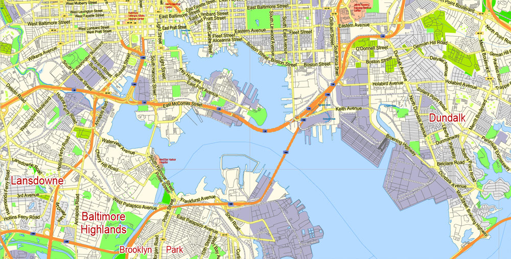
Central Baltimore, originally called the Middle District, stretches north of the Inner Harbor up to the edge of Druid Hill Park. Downtown Baltimore has mainly served as a commercial district with limited residential opportunities. However, between 2000 and 2010, the downtown population grew 130 percent as old commercial properties have been replaced by residential property. Still the city’s main commercial area and business district, it includes Baltimore’s sports complexes: Oriole Park at Camden Yards, M&T Bank Stadium, and the Royal Farms Arena; and the shops and attractions in the Inner Harbor: Harborplace, the Baltimore Convention Center, the National Aquarium, Maryland Science Center, Pier Six Pavilion, and Power Plant Live.
The University of Maryland, Baltimore, the University of Maryland Medical Center, and Lexington Market are also in the central district, as well as the Hippodrome and many nightclubs, bars, restaurants, shopping centers and various other attractions. The northern portion of Central Baltimore, between downtown and the Druid Hill Park, is home to many of the city’s cultural opportunities. Maryland Institute College of Art, the Peabody Institute (music conservatory), George Peabody Library, Enoch Pratt Free Library – Central Library, the Lyric Opera House, the Joseph Meyerhoff Symphony Hall, the Walters Art Museum, the Maryland Historical Society and its Enoch Pratt Mansion, and several galleries are located in this region.
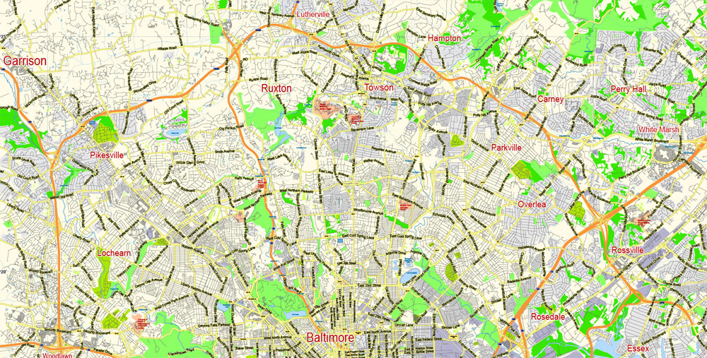
North Baltimore
North Baltimore lies directly north of Central Baltimore and is bounded on the east by The Alameda and on the west by Pimlico Road. Loyola University Maryland, Johns Hopkins University Homewood Campus, St. Mary’s Seminary and University and Notre Dame of Maryland University are located in this district. Baltimore Polytechnic Institute high school for mathematics, science and engineering, and adjacent Western High School, the oldest remaining public girls secondary school in America, share a joint campus at West Cold Spring Lane and Falls Road.
Several historic and notable neighborhoods are in this district: Roland Park (1891), Guilford (1913), Homeland (1924), Hampden, Woodberry, Old Goucher (the original campus of Goucher College), and Jones Falls. Along the York Road corridor going north are the large neighborhoods of Charles Village, Waverly, and Mount Washington. The Station North Arts and Entertainment District is also located in North Baltimore.
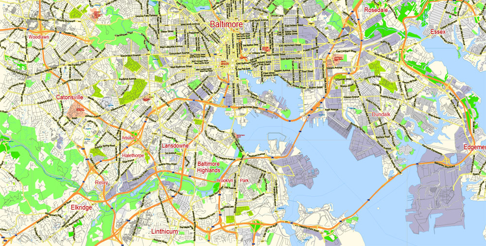
South Baltimore
South Baltimore, a mixed industrial and residential area, consists of the “Old South Baltimore” peninsula below the Inner Harbor and east of the old B&O Railroad’s Camden line tracks and Russell Street downtown. It is a culturally, ethnically, and socioeconomically diverse waterfront area with neighborhoods such as Locust Point and Riverside around a large park of the same name. Just south of the Inner Harbor, the historic Federal Hill neighborhood, is home to many working professionals, pubs and restaurants. At the end of the peninsula is historic Fort McHenry, a National Park since the end of World War I, when the old U.S. Army Hospital surrounding the 1798 star-shaped battlements was torn down.
The area south of the Vietnam Veterans (Hanover Street) Bridge and the Patapsco River was annexed to the city in 1919 from being independent towns in Anne Arundel County. Across the Hanover Street Bridge are residential areas such as Cherry Hill, Brooklyn, and Curtis Bay, with Fort Armistead bordering the city’s south side from Anne Arundel County.
Northeast Baltimore
Northeast is primarily a residential neighborhood, home to Morgan State University, bounded by the city line of 1919 on its northern and eastern boundaries, Sinclair Lane, Erdman Avenue, and Pulaski Highway to the south and The Alameda on to the west. Also in this wedge of the city on 33rd Street is Baltimore City College high school, third oldest active public secondary school in the United States, founded downtown in 1839. Across Loch Raven Boulevard is the former site of the old Memorial Stadium for the Baltimore Colts and Baltimore Orioles, now replaced by a YMCA athletic and housing complex. Lake Montebello is in Northeast Baltimore.
East Baltimore
Located below Sinclair Lane and Erdman Avenue, above Orleans Street, East Baltimore is mainly made up of residential neighborhoods. This section of East Baltimore is home to Johns Hopkins Hospital and Johns Hopkins University School of Medicine on Broadway. Notable neighborhoods include: Armistead Gardens, Broadway East, Barclay, Ellwood Park, Greenmount, and McElderry Park.
Southeast Baltimore
Southeast Baltimore, located below Fayette Street, bordering the Inner Harbor and the Northwest Branch of the Patapsco River to the west, the city line of 1919 on its eastern boundaries and the Patapsco River to the south, is a mixed industrial and residential area. Patterson Park, the “Best Backyard in Baltimore,” as well as the Highlandtown Arts District, and Johns Hopkins Bayview Medical Center are located in Southeast Baltimore. The Shops at Canton Crossing opened in 2013. The Canton neighborhood, is located along Baltimore’s prime waterfront. Other historic neighborhoods include: Fells Point, Patterson Park, Butchers Hill, Highlandtown, Greektown, Harbor East, Little Italy, and Upper Fell’s Point.
Northwest Baltimore
Northwestern is bounded by the county line to the north and west, Gwynns Falls Parkway on the south and Pimlico Road on the east, is home to Pimlico Race Course, Sinai Hospital, and the headquarters of the NAACP. Its neighborhoods are mostly residential and are dissected by Northern Parkway. The area has been the center of Baltimore’s Jewish community since after World War II. Notable neighborhoods include: Pimlico, Mount Washington, and Cheswolde, and Park Heights.
West Baltimore
West Baltimore is west of downtown and the Martin Luther King, Jr. Boulevard and is bounded by Gwynns Falls Parkway, Fremont Avenue, and West Baltimore Street. The Old West Baltimore Historic District includes the neighborhoods of Harlem Park, Sandtown-Winchester, Druid Heights, Madison Park, and Upton. Originally a predominantly German neighborhood, by the last half of the 1800s, Old West Baltimore was home to a substantial section of the city’s African American population. It became the largest neighborhood for the city’s black community and its cultural, political, and economic center. Coppin State University, Mondawmin Mall, and Edmondson Village are located in this district. The area’s crime problems have provided subject material for television series, such as The Wire. Local organizations, such as the Sandtown Habitat for Humanity and the Upton Planning Committee, have been steadily transforming parts of formerly blighted areas of West Baltimore into clean, safe communities.
Southwest Baltimore
Southwest Baltimore is bound by the Baltimore County line to the west, West Baltimore Street to the north, and Martin Luther King Jr. Boulevard and Russell Street/Baltimore-Washington Parkway (Maryland Route 295) to the east. Notable neighborhoods in Southwest Baltimore include: Pigtown, Carrolton Ridge, Ridgely’s Delight, Leakin Park, Violetville, Lakeland, and Morrell Park.
St. Agnes Hospital on Wilkens and Caton avenues is located in this district with the neighboring Cardinal Gibbons High School, which is the former site of Babe Ruth’s alma mater, St. Mary’s Industrial School. Also through this segment of Baltimore ran the beginnings of the historic National Road, which was constructed beginning in 1806 along Old Frederick Road and continuing into the county on Frederick Road into Ellicott City, Maryland. Other sides in this district are: Carroll Park, one of the city’s largest parks, the colonial Mount Clare Mansion, and Washington Boulevard, which dates to pre-Revolutionary War days as the prime route out of the city to Alexandria, Virginia, and Georgetown on the Potomac River.
Baltimore
City in Maryland
Baltimore is a major city in Maryland (see other map Baltimore high detailed) with a long history as an important seaport. Fort McHenry, birthplace of the U.S. national anthem, “The Star-Spangled Banner,” sits at the mouth of Baltimore’s Inner Harbor. Today, this harbor area offers shops, upscale crab shacks and attractions like the Civil War–era warship the USS Constellation and the National Aquarium, showcasing thousands of marine creatures.
Area
• Independent city 92.1 sq mi (239 km2)
• Land 80.9 sq mi (210 km2)
• Water 11.1 sq mi (29 km2) 12.1%
Elevation 0–480 ft (0–150 m)
Population
• Independent city 620,961 (US:30th)
• Estimate 611,648
• Density 7,561/sq mi (2,919/km2)
• Urban 2,203,663 (US: 19th)
• Metro 2,797,407 (US: 21st)
• CSA 9,625,360 (US: 4th)
Free US vector maps

Free Download Vector Map US County and State Adobe Illustrator
Free_Vector_Map_US_States_County_Map.ai
Free Download Vector Map US County and State Adobe PDF
Free_Vector_Map_US_States_County_Map.pdf

Free Download Vector Map US With States Names, Adobe Illustrator
Free_Map_of_USA_with_state_names_en.ai
Free Download Vector Map US With States Names, Adobe PDF
Free_Map_of_USA_with_state_names_en.pdf
From WIKI
Free vector map World, Adobe Illustrator, download now maps vector clipart
Map for design, projects, presentation free to use as you like.
See also: TERMS & CONDITIONS: SOFTWARE LICENSE AGREEMENT FOR DIGITAL CARTOGRAPHIC DATA.
Need more USA Vector Maps, printable and editable?

 Author: Kirill Shrayber, Ph.D. FRGS

 Street Map editable Adobe Illustrator in layers")
 Street Map editable Adobe Illustrator in layers")