Santa Barbara vector map. California, USA
Archive size: 26 Mb, zipped .AI
DPI: 300
License: Royalty Free
[Available in PDF and other formats: .DWG; .AI; .EPS; .CDR; .PPT.]
This is a Royalty Free license. You don`t pay extra: per volume sold; for each use; for period of use.
Santa Barbara (California) vector maps in Adobe Illustrator format (.AI) features (check the preview images):
Highways with names,
Major streets with names,
Major Roads,
Dam,
National Park Borders,
Minor Roads,
Big and small Rivers, small streams also,
Lake, ponds and other water bodies,
Landmark fill,
Houses,
Railway lines with stops,
Recreation zones,
Parks.
We provide detailed maps of Santa Barbara (California, USA) in AI. Also available in other formats (the same price): DWG, DXF AutoCAD, Corel Draw, EPS, PDF. Please also check other vector maps of USA cities.
Santa Barbara, California.
This vector map of Santa Barbara is used as a basis for design, editing, and further printing.
This is the most detailed, exact map of Santa Barbara for high-quality printing and polygraphy. You can always clarify the map development date by contacting us.
For your convenience, all objects on Santa Barbara vector map are divided into layers. And the editing is very easy – colors, lines, etc.
You can easily add any objects needed (e.g. shops, salons, sale points, gas station or attraction) on any layer of Santa Barbara vector map.
Santa Barbara is the county seat of Santa Barbara County in the U.S. state of California. Situated on a south-facing section of coastline, the longest such section on the West Coast of the United States, the city lies between the steeply rising Santa Ynez Mountains and the Pacific Ocean. Santa Barbara’s climate is often described as Mediterranean, and the city has been promoted as the “American Riviera”. As of 2014, the city had an estimated population of 91,196, up from 88,410 in 2010, making it the second most populous city in the county after Santa Maria. The contiguous urban area, which includes the cities of Goleta and Carpinteria, along with the unincorporated regions of Isla Vista, Montecito, Mission Canyon, Hope Ranch, Summerland, and others, has an approximate population of 220,000. The population of the entire county in 2010 was 423,895.
One of the advantages of Santa Barbara vector maps of our production is the relevance of cartographic data, we constantly update all our products.
This vector map of Santa Barbara is used by:
designers, layout designers, printers, advertisers and architects. Our product – vector maps – is designed for further editing and printing in large formats – from @Wall format (a few meters) to A-0 and A-1, A-2, A-3.
Santa Barbara map in vector format is used for design, urban planning, presentations and media visualizations.
Advertising and presentation map of Santa Barbara (usually the final designer marks the routes, and puts the client’s objects (shops, saloons, gas stations etc.)
The undoubted advantage is that people will NEVER throw out this advertising product – the map. In fact, as an advertising medium, a map is the most “long-playing” of the well-known polygraphic advertising media, with the longest lifespan, and the maximum number of interactions with the customer.
For travelers, maps are sold at the airports and gas stations around the world. Often the source is our vector maps.
Take a look, who purchases our vector maps of Santa Barbara in “Our Clients and Friends” page – these are large and small companies, from super-brands like Volvo and Starbucks, to small design studios and printing houses.
It’s very easy to work with vector maps of Santa Barbara, even for a not very experienced designer who can turn on and off the map layers, add new objects, change the colors of fill and lines according to customer requirements.
The undoubted advantage of Santa Barbara vector maps in printing is an excellent and detailed visualization, when customer can expand a large paper map and instantly define his location, find a landmark, an object or address on map, unlike using the popular electronic formats of Google and Yandex maps for example.
Printable vector maps of Santa Barbara are much more convenient and efficient than any electronic maps on your smartphone, because ALL DETAILS are displayed in the entire space of Santa Barbara map.
Useful tips on working with vector maps of cities and countries in Adobe Illustrator.
«V» – launches the Selection tool (cursor, black arrow), which makes active any vector line.
«А» – launches the Direct Selection tool (white cursor), allows you to select curve elements and drag them to the desired place.
«R» – activates the Rotate tool, which helps you rotating selected objects around the center point by 360 degrees.
«E» – gives you the opportunity to use the Eraser tool and erase unnecessary parts.
«X» – switches between Fill and Stroke in the Tools section. Try to get used to this hot key and
you will quickly understand that you can’t live and work without it.
Guides are not limited to vertical and horizontal in Adobe Illustrator. You can also create a diagonal guide for example. Moreover, you can turn any contours into guides. Select the outline and go to View > Guides > Make Guides (Create Guides), or simply press Cmd/Ctrl + 5. You can also turn the guides back into an editable object. Go to menu, View > Guides > Unlock Guides (Release Guides), select the guide you want to edit and select View > Guides > Release Guides (Reset Guides), or just press Cmd/Ctrl + Option / Alt + 5).
You will probably want to change the color scheme used on our Santa Barbara vector map.
To quickly and effectively play with colors.
Of course, you can do it manually, all objects in our Santa Barbara vector map are divided according to types and layers, and you can easily change the color gamma of vector objects in groups and layers.
But there is more effective way of working with the whole VECTOR MAP of Santa Barbara and all layers:
The overview dialog «Edit colors»/«Repaint Graphic Object» (this dialog box name can change depending on the context):
If you have selected a part or a layer of Santa Barbara vector map and open the dialog box by clicking the icon in the Control panel, on the Samples palette or the Color Catalog, or if you choose Edit > Edit Colors> Repaint Graphic Object, then the «Repaint Graphic Object» dialog box appears, and you get access to «Assign» and «Edit» tabs.
If a picture or a map fragment is not selected, and you open the dialog box by clicking the icon in the Control panel, on the Samples palette or in the Color Catalog, the «Edit Colors» dialog box appears and you can only access the «Edit» tab.
Regardless of the name at the top of the dialog box, the right-hand side always displays the color group of the current document, as well as two default color groups: Print Color and Grayscale. These color groups can be selected and used any time.
In addition to being a popular tourist and resort destination, the city economy includes a large service sector, education, technology, health care, finance, agriculture, manufacturing, and local government. In 2004, the service sector accounted for fully 35% of local employment. Education in particular is well represented, with four institutions of higher learning on the south coast (the University of California, Santa Barbara, Santa Barbara City College, Westmont College, and Antioch University). The Santa Barbara Airport serves the city, as does Amtrak (most notably the Pacific Surfliner which runs from San Diego to San Luis Obispo). U.S. Highway 101 connects the Santa Barbara area with Los Angeles to the southeast and San Francisco to the northwest. Behind the city, in and beyond the Santa Ynez Mountains, is the Los Padres National Forest, which contains several remote wilderness areas. Channel Islands National Park and Channel Islands National Marine Sanctuary are located approximately 20 miles (32 km) offshore.
Create and edit color groups of Santa Barbara vector map, and also assign colors using the «Edit Colors»/ а «Repaint Graphic Object» dialog box.
A. Creating and editing of a color group on the «Edit» tab
B. Assigning colors on the «Assign» tab
C. Select a group of colors from the «Color groups» list
The option «Repaint a graphic object» in the lower part of the dialog box allows you to preview the colors on a selected layer of Vector map, or a group of elements, and specify whether its colors will be redefined when the dialog box is closed.
The main areas of the dialog box are:
«Edit»
The «Edit» tab is designed to create a new or edit the existing color groups.
The harmony rules Menu and the Color Wheel are used to conduct experiments with color harmonies. The color wheel shows how colors are related in color harmony, and the color bars allow you to view and manipulate an individual color values. In addition, you can adjust the brightness, add and remove colors, save color groups and view colors on the selected Vector Map of Santa Barbara or a separated layers.
«Assign»
The «Assign» tab is used to view and control on how the original colors are replaced with colors from the color group like your corporate colors in the Vector Map of Santa Barbara.
The assign color ability is provided only if the entire map, layer or fragment is selected in the document. You can specify which of new colors replace the current colors, whether the spot colors should be preserved and how colors are replaced (for example, you can replace colors completely or changing the color tone while maintaining the brightness). The «Assign» tab allows you to redefine colors in the Vector Map of Santa Barbara, or in separate layers and fragments using the current color group or reducing the number of colors in the current Vector Map.
Color groups
Is a list of all saved color groups for current document (the same groups appear in the «Samples» palette). You can edit and delete the existing color groups, as well as creating a new ones using the list of “Color Groups” in the dialog box. All changes appear in the «Samples» palette.
The highlighted color group shows, which color group is currently edited.
Any color group can be selected and edited, or used to redefine the colors in the selected vector map of Santa Barbara, its fragments or elements.
Saving a color group adds this group to the specified list.
Opening the «Edit Colors»/«Repaint Graphic Object» dialog box.
Open the «Edit Colors»/«Repaint Graphic Object» dialog box using one of the following methods:
«Edit»> «Edit Colors»> «Repaint Graphic object» or «Repaint With Style».
Use these commands if you need to edit the colors in the selected vector map of Santa Barbara.
«Repaint Graphic object» button on the «Control» panel.
Use this button if you need to adjust colors of Santa Barbara vector map using the а «Repaint graphic object» dialog box.
The specified button is available if the selected vector map or its fragment contains two or more colors.
Note. This color editing method is convenient for global color adjustment in a vector map, if global colors were not used when creating a Map of Santa Barbara.
The «Edit colors» button or «Edit or apply colors» on the «Color Catalog» palette
Click this button if you need to edit colors on the «Color Catalog» palette or edit and then apply them to the selected Vector Map of Santa Barbara or its fragment.
The «Edit color group» button or «Edit or apply color group» on the «Samples» palette.
Click this button if you need to edit the colors in the specific color group or edit and apply them to the selected Vector Map of Santa Barbara or a group of its elements, for example, the whole layer “Streets and lines”. You can also double-click the color group in the Samples panel to open the dialog box.
If the map file is too large and your computer freezes or even can’t open it quickly:
1. Try to reduce the color resolution of the video card (display) to 256 colors while working with a large map.
2. Using Windows Task Manager, select all the application you don’t need, while working with map, just turn them off.
3. Launch Adobe Illustrator. (DO NOT OPEN the vector map file)
4. Start the Windows Task Manager using administrator rights > Find the “Illustrator” process > set the «real time» priority,
5. Open the file. When you see the LEGACY FONT popup window – click “OK” (do not update). You can restore the TEXT later.
6. Can also be useful: When file is opened – Edit > Settings > Basic Settings > disable smoothing. /// It looks scary, but works quickly)))
We recommend saving the file in Adobe Illustrator 10 version. It’s much more stable when working with VERY BIG size files.
Santa Barbara is located about 90 miles (145 km) WNW of Los Angeles, along the Pacific coast. This stretch of coast along southern Santa Barbara County is sometimes referred to as “The American Riviera”, presumably because its geography and climate are similar to that of areas along the northern Mediterranean Sea coast (especially in southern France) known as the Riviera. The Santa Ynez Mountains, an east–west trending range, rise dramatically behind the city, with several peaks exceeding 4,000 feet (1,200 m). Covered with chaparral and sandstone outcrops, they make a scenic backdrop to the town. Sometimes, perhaps once every three years, snow falls on the mountains, but it rarely stays for more than a few days. Nearer to town, directly east and adjacent to Mission Santa Barbara, is an east-west ridge known locally as “the Riviera,” traversed by a road called “Alameda Padre Serra” (shortened APS, which translates to “Father Serra’s pathway”).
According to the United States Census Bureau, the city has a total area of 42.0 square miles (108.8 km2), of which 19.5 square miles (51 km2) of it is land and 22.5 square miles (58 km2) of it (53.61%) is water. The high official figures for water is due to the extension of the city limit into the ocean, including a strip of city reaching out into the sea and inland again to keep the Santa Barbara Airport (SBA) within the city boundary.
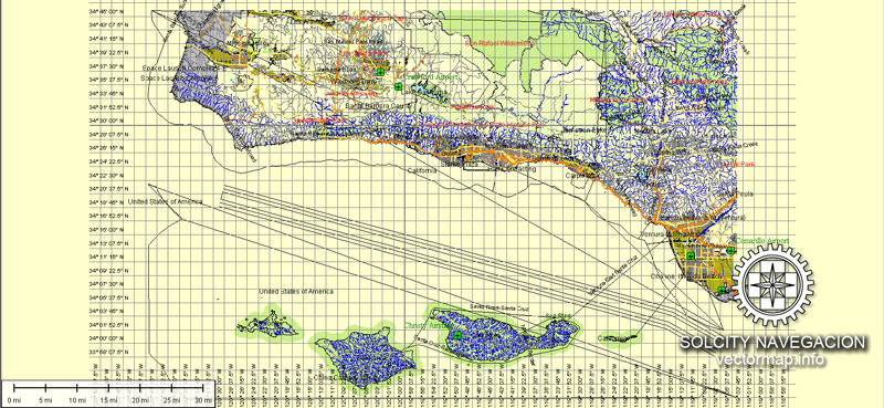
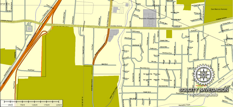
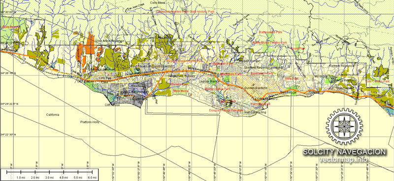
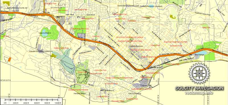
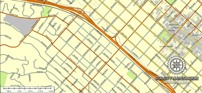
Please see preview image of this vectorial city maps of Santa Barbara. It has major and minor streets, and the most significant features like airports, parks and recreational zones.
This vector maps of Santa Barbara can be used for large size printing (wall or bigboard) or presentation projects. Zoom without quality loss, cause it`s vector map.
The same price for every format you choose.
Fully editable vector map of Santa Barbara, California. You can change fonts, colors of all objects mentioned above. This layered vector map is scalable and can be adjusted to any size you need, no matter what big it is. Zoom without quality loss.
You can edit all map data using different vector graphics editors like Adobe Illustrator, Freehand or CorelDraw, cropping, changing colors, fonts or borders, also adding your company logo or necessary objects. And also is a fully scalable map, no matter what size you need.
Probably you need more data on map? Please feel free to contact us, and we add it with no problem.
Santa Barbara map (California, USA) in vector. Cities and counties near
Our vector map of Santa Barbara includes maps of the nearest areas (see the preview):
Honda Valley, Elings Park, Campanil, Hitchcock, Samarkand, Foothill, Mission Canyon, Cielito, Palma Park, Eastside, Riviera, East Beach, Isla Vista, Goleta, More Mesa, Hope Ranch.
Santa Barbara map for Adobe Illustrator. Purchasing and downloading.
We accept PayPal and Credit Card payment. After the payment you will be redirected to the download page.
We have the biggest base of USA Vector Maps and other countries. Maps containing streets with names, buildings, railways and airports (see the list of POI above).
See more North America`s cities Vector Maps
For example: Honolulu, Oahu, Hawaii, printable vector street map, City Plan full editable
Vector map Topeka, US printable vector street City Plan map
Vector map Tuscaloosa, Alabama, US
Santa Barbara city vector map (California, USA)
Vectorial map of Seattle (Washington) in Adobe Illustrator
Small guide: How to work with the vector map?
You can: Mass select objects by type and color – for example, the objects type “building” (they are usually dark gray) – and remove them from the map, if you do not need them in your print or design project. You can also easily change the thickness of lines (streets), just bulk selection the road by the line color.
The streets are separated by type, for example, type “residential road” are usually white with a gray stroke. Highway usually orange with a brown or dark gray stroke.
All objects are divided by types: different types of roads and streets, polygons of buildings, landfills, urban areas, parks and more other.
It is easy to change the font of inscriptions, all or each individually. Also, just can be make and any other manipulation of objects on the vector map in Adobe illustrator format.
Important: All the proportions on the map are true, that is, the relative sizes of the objects are true, because Map is based on an accurate GPS projection, and It transated into the (usual for all) the Mercator projection.
You can easily change the color, stroke and fill of any object on the map, zoom without loss of quality Image Verification.


 Author: Kirill Shrayber, Ph.D. FRGS

