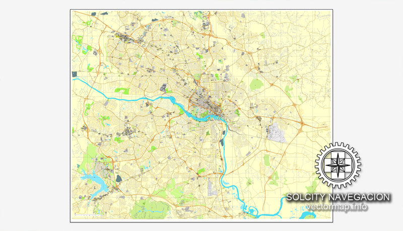
Richmond, Virginia, US printable vector street City Plan map, full editable, Adobe PDF, full vector, scalable, editable, text format street names, 31 mb ZIP
All streets, some buildings. Map for design, print, arts, projects, presentations.
You can edit this file by Adobe Illustrator, Adobe Acrobat, Corel Draw.
DWG, DXF, CDR and other formats – on request, same price, please, contact
Richmond, Virginia, USA.
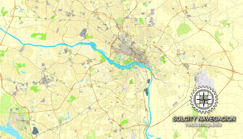
This vector map of Richmond city is used as a basis for design, editing, and further printing.
This is the most detailed, exact map of Richmond city for high-quality printing and polygraphy. You can always clarify the map development date by contacting us.
For your convenience, all objects on Richmond vector city map are divided into layers. And the editing is very easy – colors, lines, etc.
You can easily add any objects needed (e.g. shops, salons, sale points, gas station or attraction) on any layer of Richmond vector map.
Richmond is the capital of the Commonwealth of Virginia in the United States. It is the center of the Richmond Metropolitan Statistical Area (MSA) and the Greater Richmond Region. Richmond was incorporated in 1742 and has been an independent city since 1871.
One of the advantages of Richmond city vector maps of our production is the relevance of cartographic data, we constantly update all our products.
This vector map of Richmond city is used by:
designers, layout designers, printers, advertisers and architects. Our product – vector maps – is designed for further editing and printing in large formats – from @Wall format (a few meters) to A-0 and A-1, A-2, A-3.
The Richmond city map in vector format is used for design, urban planning, presentations and media visualizations.
The advertising and presentation map of Richmond city (usually the final designer marks the routes, and puts the client’s objects (shops, saloons, gas stations etc.)
The undoubted advantage is that people will NEVER throw out this advertising product – the map. In fact, as an advertising medium, a city map is the most “long-playing” of the well-known polygraphic advertising media, with the longest lifespan, and the maximum number of interactions with the customer.
As of the 2010 census, the city’s population was 204,214; in 2016, the population was estimated to be 223,170, making Richmond the fourth-most populous city in Virginia. The Richmond Metropolitan Area has a population of 1,260,029, the third-most populous metro in the state.
For travelers, maps are sold at the airports and gas stations around the world. Often the source is our vector maps.
Take a look, who purchases our vector maps of Richmond city in “Our Clients and Friends” page – these are large and small companies, from super-brands like Volvo and Starbucks, to small design studios and printing houses.
It’s very easy to work with vector maps of Richmond city, even for a not very experienced designer who can turn on and off the map layers, add new objects, change the colors of fill and lines according to customer requirements.
The undoubted advantage of Richmond city vector maps in printing is an excellent and detailed visualization, when customer can expand a large paper map and instantly define his location, find a landmark, an object or address on map, unlike using the popular electronic formats of Google and Yandex maps for example.
Richmond is located at the fall line of the James River, 44 miles (71 km) west of Williamsburg, 66 miles (106 km) east of Charlottesville, 100 miles (160 km) east of Lynchburg and 98 miles (158 km) south of Washington, D.C. Surrounded by Henrico and Chesterfield counties, the city is located at the intersections of Interstate 95 and Interstate 64, and encircled by Interstate 295 and Virginia State Route 288. Major suburbs include Midlothian to the southwest, Chesterfield to the south, Varina to the southeast, Sandston to the east, Glen Allen to the north and west, Short Pump to the west and Mechanicsville to the northeast.
Printable vector maps of Richmond city are much more convenient and efficient than any electronic maps on your smartphone, because ALL DETAILS are displayed in the entire space of Richmond city map.
Useful tips on working with vector maps of cities and countries in Adobe Illustrator.
«V» – launches the Selection tool (cursor, black arrow), which makes active any vector line.
«А» – launches the Direct Selection tool (white cursor), allows you to select curve elements and drag them to the desired place.
«R» – activates the Rotate tool, which helps you rotating selected objects around the center point by 360 degrees.
«E» – gives you the opportunity to use the Eraser tool and erase unnecessary parts.
«X» – switches between Fill and Stroke in the Tools section. Try to get used to this hot key and
you will quickly understand that you can’t live and work without it.
The site of Richmond had been an important village of the Powhatan Confederacy, and was briefly settled by English colonists from Jamestown in 1609, and in 1610–1611. The present city of Richmond was founded in 1737. It became the capital of the Colony and Dominion of Virginia in 1780, replacing Williamsburg. During the Revolutionary War period, several notable events occurred in the city, including Patrick Henry’s “Give me liberty or give me death” speech in 1775 at St. John’s Church, and the passage of the Virginia Statute for Religious Freedom written by Thomas Jefferson. During the American Civil War, Richmond served as the second and permanent capital of the Confederate States of America. The city entered the 20th century with one of the world’s first successful electric streetcar systems. The Jackson Ward neighborhood is a national hub of African-American commerce and culture.

Guides are not limited to vertical and horizontal in Adobe Illustrator. You can also create a diagonal guide for example. Moreover, you can turn any contours into guides. Select the outline and go to View > Guides > Make Guides (Create Guides), or simply press Cmd/Ctrl + 5. You can also turn the guides back into an editable object. Go to menu, View > Guides > Unlock Guides (Release Guides), select the guide you want to edit and select View > Guides > Release Guides (Reset Guides), or just press Cmd/Ctrl + Option / Alt + 5).
You will probably want to change the color scheme used on our Richmond vector city map.
To quickly and effectively play with colors.
Of course, you can do it manually, all objects in our Richmond city vector map are divided according to types and layers, and you can easily change the color gamma of vector objects in groups and layers.
Richmond’s economy is primarily driven by law, finance, and government, with federal, state, and local governmental agencies, as well as notable legal and banking firms, located in the downtown area. The city is home to both the United States Court of Appeals for the Fourth Circuit, one of 13 United States courts of appeals, and the Federal Reserve Bank of Richmond, one of 12 Federal Reserve Banks. Dominion Energy and WestRock, Fortune 500 companies, are headquartered in the city, with others in the metropolitan area.
But there is more effective way of working with the whole VECTOR MAP of Richmond city and all layers:
The overview dialog «Edit colors»/«Repaint Graphic Object» (this dialog box name can change depending on the context):
If you have selected a part or a layer of Richmond city vector map and open the dialog box by clicking the icon in the Control panel, on the Samples palette or the Color Catalog, or if you choose Edit > Edit Colors> Repaint Graphic Object, then the «Repaint Graphic Object» dialog box appears, and you get access to «Assign» and «Edit» tabs.
If a picture or a map fragment is not selected, and you open the dialog box by clicking the icon in the Control panel, on the Samples palette or in the Color Catalog, the «Edit Colors» dialog box appears and you can only access the «Edit» tab.
Regardless of the name at the top of the dialog box, the right-hand side always displays the color group of the current document, as well as two default color groups: Print Color and Grayscale. These color groups can be selected and used any time.
Geography and climate
Richmond is located at 37°32′N 77°28′W (37.538, −77.462). According to the United States Census Bureau, the city has a total area of 62 square miles (160 km2), of which 60 square miles (160 km2) is land and 2.7 square miles (7.0 km2) of it (4.3%) is water. The city is located in the Piedmont region of Virginia, at the highest navigable point of the James River. The Piedmont region is characterized by relatively low, rolling hills, and lies between the low, flat Tidewater region and the Blue Ridge Mountains. Significant bodies of water in the region include the James River, the Appomattox River, and the Chickahominy River.

Create and edit color groups of Richmond city vector map, and also assign colors using the «Edit Colors»/ а «Repaint Graphic Object» dialog box.
A. Creating and editing of a color group on the «Edit» tab
B. Assigning colors on the «Assign» tab
C. Select a group of colors from the «Color groups» list
The option «Repaint a graphic object» in the lower part of the dialog box allows you to preview the colors on a selected layer of Vector map, or a group of elements, and specify whether its colors will be redefined when the dialog box is closed.
The Richmond-Petersburg Metropolitan Statistical Area (MSA), the 44th largest in the United States, includes the independent cities of Richmond, Colonial Heights, Hopewell, and Petersburg, as well as the counties of Charles City, Chesterfield, Dinwiddie, Goochland, Hanover, Henrico, New Kent, Powhatan, and Prince George. As of July 1, 2009, the total population of the Richmond—Petersburg MSA was 1,258,251.
The main areas of the dialog box are:
«Edit»
The «Edit» tab is designed to create a new or edit the existing color groups.
The harmony rules Menu and the Color Wheel are used to conduct experiments with color harmonies. The color wheel shows how colors are related in color harmony, and the color bars allow you to view and manipulate an individual color values. In addition, you can adjust the brightness, add and remove colors, save color groups and view colors on the selected Vector Map of Richmond city or a separated layers.
«Assign»
The «Assign» tab is used to view and control on how the original colors are replaced with colors from the color group like your corporate colors in the Vector Map of Richmond city.
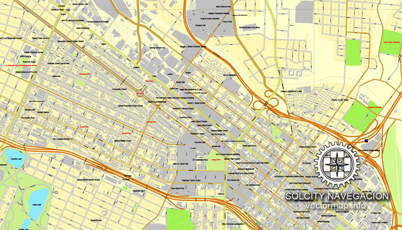
Cityscape
Richmond’s original street grid, laid out in 1737, included the area between what are now Broad, 17th, and 25th Streets and the James River. Modern Downtown Richmond is located slightly farther west, on the slopes of Shockoe Hill. Nearby neighborhoods include Shockoe Bottom, the historically significant and low-lying area between Shockoe Hill and Church Hill, and Monroe Ward, which contains the Jefferson Hotel.
The assign color ability is provided only if the entire map, layer or fragment is selected in the document. You can specify which of new colors replace the current colors, whether the spot colors should be preserved and how colors are replaced (for example, you can replace colors completely or changing the color tone while maintaining the brightness). The «Assign» tab allows you to redefine colors in the Vector Map of Richmond city, or in separate layers and fragments using the current color group or reducing the number of colors in the current Vector Map.
Color groups
Is a list of all saved color groups for current document (the same groups appear in the «Samples» palette). You can edit and delete the existing color groups, as well as creating a new ones using the list of “Color Groups” in the dialog box. All changes appear in the «Samples» palette.
The highlighted color group shows, which color group is currently edited.
Richmond’s East End includes neighborhoods like rapidly gentrifying Church Hill, home to St. John’s Church, as well as poorer areas like Fulton, Union Hill, and Fairmont, and public housing projects like Mosby Court, Whitcomb Court, Fairfield Court, and Creighton Court closer to Interstate 64. The area between Belvidere Street, Interstate 195, Interstate 95, and the river, which includes Virginia Commonwealth University, is socioeconomically and architecturally diverse.
Any color group can be selected and edited, or used to redefine the colors in the selected vector map of Richmond city, its fragments or elements.
Saving a color group adds this group to the specified list.
Opening the «Edit Colors»/«Repaint Graphic Object» dialog box.
Open the «Edit Colors»/«Repaint Graphic Object» dialog box using one of the following methods:
«Edit»> «Edit Colors»> «Repaint Graphic object» or «Repaint With Style».
Use these commands if you need to edit the colors in the selected vector map of Richmond city.
«Repaint Graphic object» button on the «Control» panel.
Use this button if you need to adjust colors of Richmond city vector map using the а «Repaint graphic object» dialog box.
The specified button is available if the selected vector map or its fragment contains two or more colors.
Note. This color editing method is convenient for global color adjustment in a vector map, if global colors were not used when creating a City Map of Richmond.
The «Edit colors» button or «Edit or apply colors» on the «Color Catalog» palette
Click this button if you need to edit colors on the «Color Catalog» palette or edit and then apply them to the selected Vector Map of Richmond city or its fragment.
The «Edit color group» button or «Edit or apply color group» on the «Samples» palette.
Click this button if you need to edit the colors in the specific color group or edit and apply them to the selected Vector Map of Richmond city or a group of its elements, for example, the whole layer “Streets and lines”. You can also double-click the color group in the Samples panel to open the dialog box.
If the map file is too large and your computer freezes or even can’t open it quickly:
1. Try to reduce the color resolution of the video card (display) to 256 colors while working with a large map.
2. Using Windows Task Manager, select all the application you don’t need, while working with map, just turn them off.
3. Launch Adobe Illustrator. (DO NOT OPEN the vector map file)
4. Start the Windows Task Manager using administrator rights > Find the “Illustrator” process > set the «real time» priority,
5. Open the file. When you see the LEGACY FONT popup window – click “OK” (do not update). You can restore the TEXT later.
6. Can also be useful: When file is opened – Edit > Settings > Basic Settings > disable smoothing. /// It looks scary, but works quickly)))
We recommend saving the file in Adobe Illustrator 10 version. It’s much more stable when working with VERY BIG size files.
North of Broad Street, the Carver and Newtowne West neighborhoods are demographically similar to neighboring Jackson Ward, with Carver experiencing some gentrification due to its proximity to VCU. The affluent area between the Boulevard, Main Street, Broad Street, and VCU, known as the Fan, is home to Monument Avenue, an outstanding collection of Victorian architecture, and many students. West of the Boulevard is the Museum District, the location of the Virginia Historical Society and the Virginia Museum of Fine Arts. South of the Downtown Expressway are Byrd Park, Maymont, Hollywood Cemetery, the predominantly black working class Randolph neighborhood, and white working class Oregon Hill. Cary Street between Interstate 195 and the Boulevard is a popular commercial area called Carytown.
Richmond’s Northside is home to numerous listed historic districts. Neighborhoods such as Chestnut Hill-Plateau and Barton Heights began to develop at the end of the 19th century when the new streetcar system made it possible for people to live on the outskirts of town and still commute to jobs downtown. Other prominent Northside neighborhoods include Azalea, Barton Heights, Bellevue, Chamberlayne, Ginter Park, Highland Park, and Rosedale.
Farther west is the affluent, suburban West End. Windsor Farms is among its best-known sections. The West End also includes middle to lower income neighborhoods, such as Laurel, Farmington and the areas surrounding the Regency Mall. More affluent areas include Glen Allen, Short Pump, and the areas of Tuckahoe away from Regency Mall, which can all be found north and northwest of the city. The University of Richmond and the Country Club of Virginia can be found here as well, which are located just inside the City Limits.
The portion of the city south of the James River is known as the Southside. Neighborhoods in the city’s Southside area range from affluent and middle class suburban neighborhoods Westover Hills, Forest Hill, Southampton, Stratford Hills, Oxford, Huguenot Hills, Hobby Hill, and Woodland Heights to the impoverished Manchester and Blackwell areas, the Hillside Court housing projects, and the ailing Jefferson Davis Highway commercial corridor. Other Southside neighborhoods include Fawnbrook, Broad Rock, Cherry Gardens, Cullenwood, and Beaufont Hills. Much of Southside developed a suburban character as part of Chesterfield County before being annexed by Richmond, most notably in 1970.
Small guide: How to work with the vector map?
You can: Mass select objects by type and color – for example, the objects type “building” (they are usually dark gray) – and remove them from the map, if you do not need them in your print or design project. You can also easily change the thickness of lines (streets), just bulk selection the road by the line color.
The streets are separated by type, for example, type “residential road” are usually white with a gray stroke. Highway usually orange with a brown or dark gray stroke.
It is easy to change the font of inscriptions, all or each individually. Also, just can be make and any other manipulation of objects on the vector map in Adobe illustrator format.
Important: All the proportions on the map are true, that is, the relative sizes of the objects are true, because Map is based on an accurate GPS projection, and It transated into the (usual for all) the Mercator projection.
You can easily change the color, stroke and fill of any object on the map, zoom without loss of quality Image Verification.
Select object

Bulk selection the same objects on the vector map

See the bulk selected objects on the vector map

Bulk delete buildungs from the vector map

Select residencial road (small street) on the vector map

Bulk selection the same lines (streets, roads) on the full map

Create fat lines of the streets on the vector maps (bulk action) 1

Create fat lines of the streets on the vector maps (bulk action) 2

Create fat lines of the streets on the vector maps (bulk action) 3

You can easily change the color, stroke and fill of any object on the map, zoom without loss of quality Image Verification.

 Author: Kirill Shrayber, Ph.D. FRGS
 City Plan editable Adobe Illustrator Street Map in layers")
