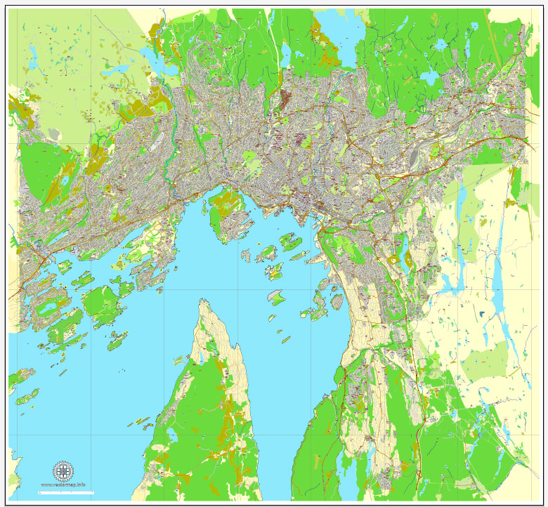
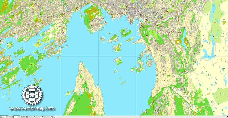
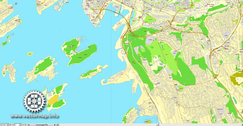
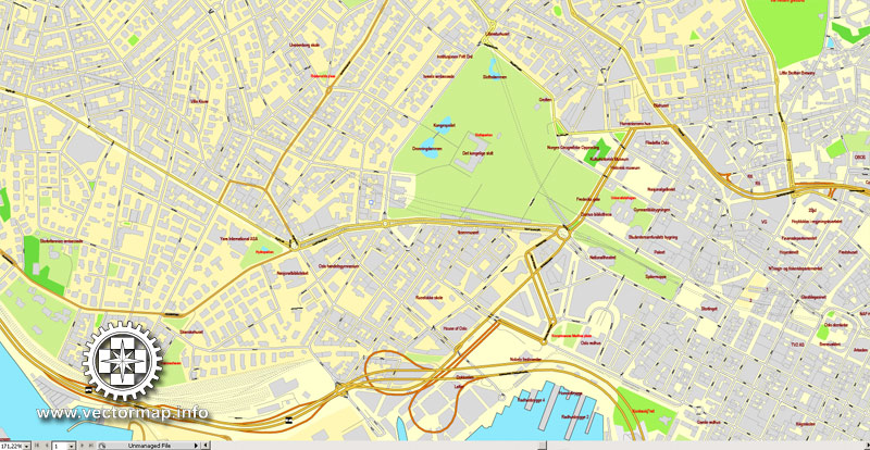
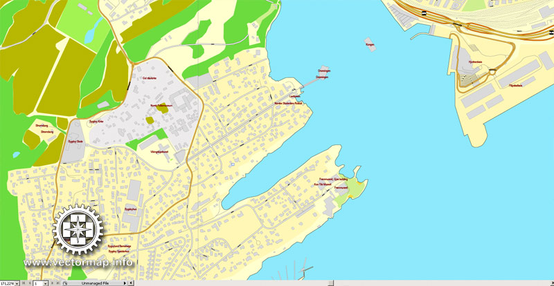
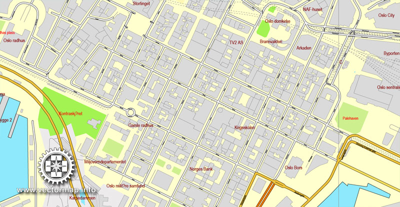
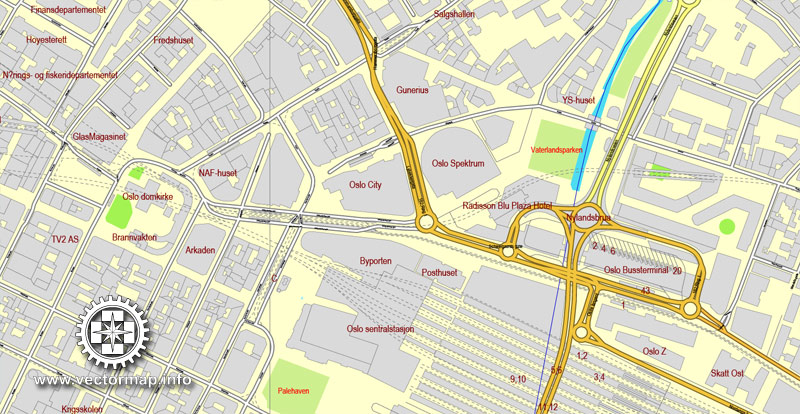
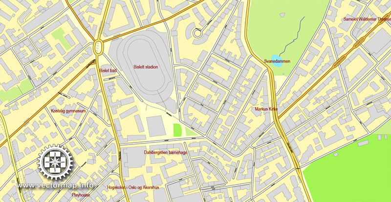
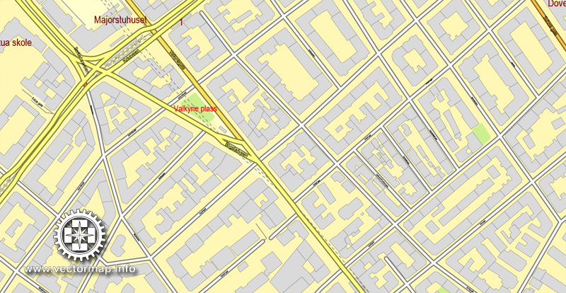
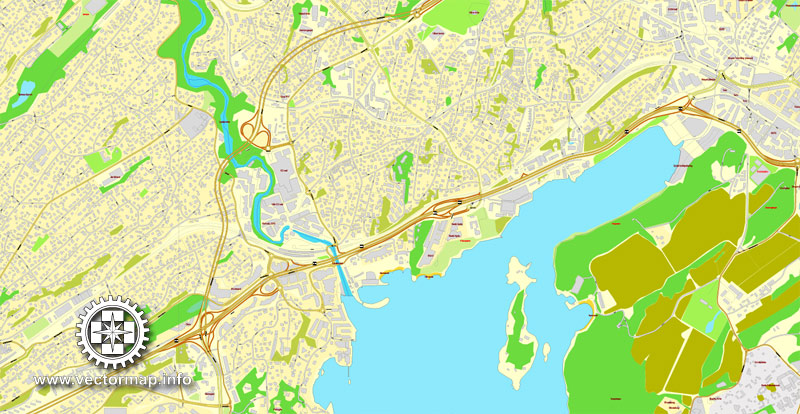
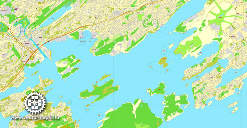
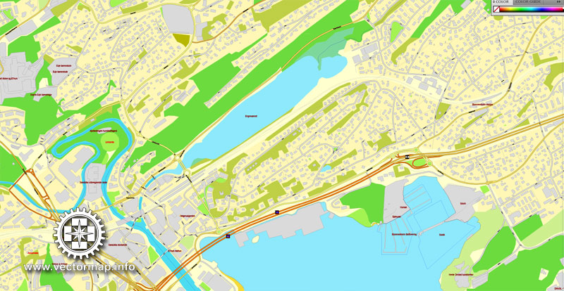
Oslo, Norway, printable vector street map, exact City Plan V.2 full editable, Adobe PDF, Royalty free, full vector, scalable, editable, text format street names, 29 mb ZIP
All streets, All buildings. Map for design, printing, publications, arts, projects, presentations, for architects, designers and builders, business, logistics. The most exact and detailed map of the city.
You can edit this file by Adobe Illustrator, Adobe Acrobat, Corel Draw.
Different font colors of the street names (black); object names by type (brown, red).
DXF, DWG, CDR and other formats – on request, same price, please, contact
Oslo, Norway.
This vector map of Oslo city is used as a basis for design, editing, and further printing.
This is the most detailed, exact map of Oslo city for high-quality printing and polygraphy. You can always clarify the map development date by contacting us.
For your convenience, all objects on Oslo vector city map are divided into layers. And the editing is very easy – colors, lines, etc.
You can easily add any objects needed (e.g. shops, salons, sale points, gas station or attraction) on any layer of Oslo vector map.
Oslo is the capital and most populous city of Norway. It constitutes both a county and a municipality. Founded in the year 1040 as Ánslo, and established as a kaupstad or trading place in 1048 by Harald Hardrada, the city was elevated to a bishopric in 1070 and a capital under Haakon V of Norway around 1300. Personal unions with Denmark from 1397 to 1523 and again from 1536 to 1814 and with Sweden from 1814 to 1905 reduced its influence. After being destroyed by a fire in 1624, during the reign of King Christian IV, a new city was built closer to Akershus Fortress and named Christiania in the king’s honour. It was established as a municipality (formannskapsdistrikt) on 1 January 1838. The city’s name was spelled Kristiania between 1877 and 1897 by state and municipal authorities, respectively. In 1925 the city was renamed Oslo.
One of the advantages of Oslo city vector maps of our production is the relevance of cartographic data, we constantly update all our products.
This vector map of Oslo city is used by:
designers, layout designers, printers, advertisers and architects. Our product – vector maps – is designed for further editing and printing in large formats – from @Wall format (a few meters) to A-0 and A-1, A-2, A-3.
The Oslo city map in vector format is used for design, urban planning, presentations and media visualizations.
The advertising and presentation map of Oslo city (usually the final designer marks the routes, and puts the client’s objects (shops, saloons, gas stations etc.)
The undoubted advantage is that people will NEVER throw out this advertising product – the map. In fact, as an advertising medium, a city map is the most “long-playing” of the well-known polygraphic advertising media, with the longest lifespan, and the maximum number of interactions with the customer.
For travelers, maps are sold at the airports and gas stations around the world. Often the source is our vector maps.
Take a look, who purchases our vector maps of Oslo city in “Our Clients and Friends” page – these are large and small companies, from super-brands like Volvo and Starbucks, to small design studios and printing houses.
It’s very easy to work with vector maps of Oslo city, even for a not very experienced designer who can turn on and off the map layers, add new objects, change the colors of fill and lines according to customer requirements.
The undoubted advantage of Oslo city vector maps in printing is an excellent and detailed visualization, when customer can expand a large paper map and instantly define his location, find a landmark, an object or address on map, unlike using the popular electronic formats of Google and Yandex maps for example.
Printable vector maps of Oslo city are much more convenient and efficient than any electronic maps on your smartphone, because ALL DETAILS are displayed in the entire space of Oslo city map.

Useful tips on working with vector maps of cities and countries in Adobe Illustrator.
«V» – launches the Selection tool (cursor, black arrow), which makes active any vector line.
«А» – launches the Direct Selection tool (white cursor), allows you to select curve elements and drag them to the desired place.
«R» – activates the Rotate tool, which helps you rotating selected objects around the center point by 360 degrees.
«E» – gives you the opportunity to use the Eraser tool and erase unnecessary parts.
«X» – switches between Fill and Stroke in the Tools section. Try to get used to this hot key and
you will quickly understand that you can’t live and work without it.
Guides are not limited to vertical and horizontal in Adobe Illustrator. You can also create a diagonal guide for example. Moreover, you can turn any contours into guides. Select the outline and go to View > Guides > Make Guides (Create Guides), or simply press Cmd/Ctrl + 5. You can also turn the guides back into an editable object. Go to menu, View > Guides > Unlock Guides (Release Guides), select the guide you want to edit and select View > Guides > Release Guides (Reset Guides), or just press Cmd/Ctrl + Option / Alt + 5).
You will probably want to change the color scheme used on our Oslo vector city map.
To quickly and effectively play with colors.
Of course, you can do it manually, all objects in our Oslo city vector map are divided according to types and layers, and you can easily change the color gamma of vector objects in groups and layers.
But there is more effective way of working with the whole VECTOR MAP of Oslo city and all layers:
The overview dialog «Edit colors»/«Repaint Graphic Object» (this dialog box name can change depending on the context):
If you have selected a part or a layer of Oslo city vector map and open the dialog box by clicking the icon in the Control panel, on the Samples palette or the Color Catalog, or if you choose Edit > Edit Colors> Repaint Graphic Object, then the «Repaint Graphic Object» dialog box appears, and you get access to «Assign» and «Edit» tabs.
If a picture or a map fragment is not selected, and you open the dialog box by clicking the icon in the Control panel, on the Samples palette or in the Color Catalog, the «Edit Colors» dialog box appears and you can only access the «Edit» tab.
Regardless of the name at the top of the dialog box, the right-hand side always displays the color group of the current document, as well as two default color groups: Print Color and Grayscale. These color groups can be selected and used any time.
Oslo is the economic and governmental centre of Norway. The city is also a hub of Norwegian trade, banking, industry and shipping. It is an important centre for maritime industries and maritime trade in Europe. The city is home to many companies within the maritime sector, some of which are among the world’s largest shipping companies, shipbrokers and maritime insurance brokers. Oslo is a pilot city of the Council of Europe and the European Commission intercultural cities programme.
Oslo is considered a global city and was ranked “Beta World City” in studies carried out by the Globalization and World Cities Study Group and Network in 2008. It was ranked number one in terms of quality of life among European large cities in the European Cities of the Future 2012 report by fDi magazine. A survey conducted by ECA International in 2011 placed Oslo as the second most expensive city in the world for living expenses after Tokyo. In 2013 Oslo tied with the Australian city of Melbourne as the fourth most expensive city in the world, according to the Economist Intelligence Unit (EIU)’s Worldwide Cost of Living study.
As of 1 July 2017, the municipality of Oslo had a population of 672,061, while the population of the city’s urban area of 3 December 2018 was 1,000,467. The metropolitan area had an estimated population of 1.71 million. The population was increasing at record rates during the early 2000s, making it the fastest growing major city in Europe at the time. This growth stems for the most part from international immigration and related high birth rates, but also from intra-national migration. The immigrant population in the city is growing somewhat faster than the Norwegian population, and in the city proper this is now more than 25% of the total if people with immigrant parents are included.
Geography
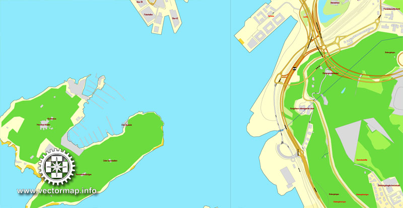
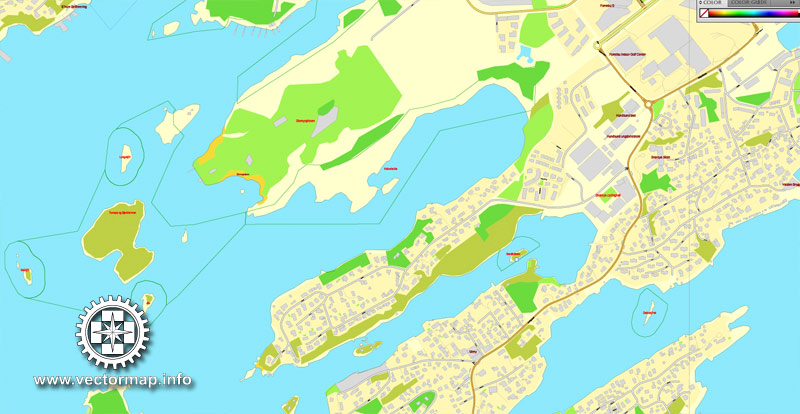
Oslo occupies an arc of land at the northernmost end of the Oslofjord. The fjord, which is nearly bisected by the Nesodden peninsula opposite Oslo, lies to the south; in all other directions Oslo is surrounded by green hills and mountains. There are 40 islands within the city limits, the largest being Malmøya (0.56 km2 or 0.22 sq mi), and scores more around the Oslofjord. Oslo has 343 lakes, the largest being Maridalsvannet (3.91 km2 or 1.51 sq mi). This is also a main source of drinking water for large parts of Oslo.
Although Eastern Norway has a number of rivers, none of these flow into the ocean at Oslo. Instead Oslo has two smaller rivers: Akerselva (draining Maridalsvannet, which flows into the fjord in Bjørvika), and Alna. The waterfalls in Akerselva gave power to some of the first modern industry of Norway in the 1840s. Later in the century, the river became the symbol of the stable and consistent economic and social divide of the city into an East End and a West End; the labourers’ neighbourhoods lie on both sides of the river, and the divide in reality follows Uelands street a bit further west. River Alna flows through Groruddalen, Oslo’s major suburb and industrial area. The highest point is Kirkeberget, at 629 metres (2,064 ft). Although the city’s population is small compared to most European capitals, it occupies an unusually large land area, of which two-thirds are protected areas of forests, hills and lakes. Its boundaries encompass many parks and open areas, giving it an airy and green appearance.
Parks and recreation areas
Frogner Park
Oslo has a large number of parks and green areas within the city core, as well as outside it.
Frogner Park is a large park located a few minutes’ walk away from the city centre. This is the biggest and best-known park in Norway, with a large collection of sculptures by Gustav Vigeland.
Bygdøy is a large green area, commonly called the Museum Peninsula of Oslo. The area is surrounded by the sea and is one of the most expensive districts in Norway.
Ekebergparken Sculpture Park is a sculpture park and a national heritage park with a panoramic view of the city at Ekeberg in the southeast of the city.
St. Hanshaugen Park is an old public park on a high hill in central Oslo. “St. Hanshaugen” is also the name of the surrounding neighbourhood as well as the larger administrative district (borough) that includes major parts of central Oslo.
Tøyen Park stretches out behind the Munch Museum, and is a vast, grassy expanse. In the north, there is a lookout point known as Ola Narr. The Tøyen area also includes the Botanical Garden and Museum belonging to the University of Oslo.
Oslo (with neighbouring Sandvika-Asker) is built in a horseshoe shape on the shores of the Oslofjord and limited in most directions by hills and forests. As a result, any point within the city is relatively close to the forest. There are two major forests bordering the city: Østmarka (literally “Eastern Forest”, on the eastern perimeter of the city), and the very large Nordmarka (literally “Northern Forest”, stretching from the northern perimeter of the city deep into the hinterland).
Create and edit color groups of Oslo city vector map, and also assign colors using the «Edit Colors»/ а «Repaint Graphic Object» dialog box.
A. Creating and editing of a color group on the «Edit» tab
B. Assigning colors on the «Assign» tab
C. Select a group of colors from the «Color groups» list
The option «Repaint a graphic object» in the lower part of the dialog box allows you to preview the colors on a selected layer of Vector map, or a group of elements, and specify whether its colors will be redefined when the dialog box is closed.
The main areas of the dialog box are:
«Edit»
The «Edit» tab is designed to create a new or edit the existing color groups.
The harmony rules Menu and the Color Wheel are used to conduct experiments with color harmonies. The color wheel shows how colors are related in color harmony, and the color bars allow you to view and manipulate an individual color values. In addition, you can adjust the brightness, add and remove colors, save color groups and view colors on the selected Vector Map of Oslo city or a separated layers.
«Assign»
The «Assign» tab is used to view and control on how the original colors are replaced with colors from the color group like your corporate colors in the Vector Map of Oslo city.
The assign color ability is provided only if the entire map, layer or fragment is selected in the document. You can specify which of new colors replace the current colors, whether the spot colors should be preserved and how colors are replaced (for example, you can replace colors completely or changing the color tone while maintaining the brightness). The «Assign» tab allows you to redefine colors in the Vector Map of Oslo city, or in separate layers and fragments using the current color group or reducing the number of colors in the current Vector Map.
Color groups
Is a list of all saved color groups for current document (the same groups appear in the «Samples» palette). You can edit and delete the existing color groups, as well as creating a new ones using the list of “Color Groups” in the dialog box. All changes appear in the «Samples» palette.
The highlighted color group shows, which color group is currently edited.
Any color group can be selected and edited, or used to redefine the colors in the selected vector map of Oslo city, its fragments or elements.
Sognsvann is a lake in Oslomarka, located at the land border, just north of Oslo. Sognsvann was drinking water for Oslo from 1876 to 1967.
The lake’s altitude above sea level is 183 metres. The water is in a popular hiking area. Near the water itself, it is great for barbecues, swimming, beach volleyball and other activities.
Saving a color group adds this group to the specified list.
Opening the «Edit Colors»/«Repaint Graphic Object» dialog box.
Open the «Edit Colors»/«Repaint Graphic Object» dialog box using one of the following methods:
«Edit»> «Edit Colors»> «Repaint Graphic object» or «Repaint With Style».
Use these commands if you need to edit the colors in the selected vector map of Oslo city.
«Repaint Graphic object» button on the «Control» panel.
Use this button if you need to adjust colors of Oslo city vector map using the а «Repaint graphic object» dialog box.
The specified button is available if the selected vector map or its fragment contains two or more colors.
Note. This color editing method is convenient for global color adjustment in a vector map, if global colors were not used when creating a City Map of Oslo.
The «Edit colors» button or «Edit or apply colors» on the «Color Catalog» palette
Click this button if you need to edit colors on the «Color Catalog» palette or edit and then apply them to the selected Vector Map of Oslo city or its fragment.
The «Edit color group» button or «Edit or apply color group» on the «Samples» palette.
Click this button if you need to edit the colors in the specific color group or edit and apply them to the selected Vector Map of Oslo city or a group of its elements, for example, the whole layer “Streets and lines”. You can also double-click the color group in the Samples panel to open the dialog box.
If the map file is too large and your computer freezes or even can’t open it quickly:
1. Try to reduce the color resolution of the video card (display) to 256 colors while working with a large map.
2. Using Windows Task Manager, select all the application you don’t need, while working with map, just turn them off.
3. Launch Adobe Illustrator. (DO NOT OPEN the vector map file)
4. Start the Windows Task Manager using administrator rights > Find the “Illustrator” process > set the «real time» priority,
5. Open the file. When you see the LEGACY FONT popup window – click “OK” (do not update). You can restore the TEXT later.
6. Can also be useful: When file is opened – Edit > Settings > Basic Settings > disable smoothing. /// It looks scary, but works quickly)))
We recommend saving the file in Adobe Illustrator 10 version. It’s much more stable when working with VERY BIG size files.
The municipality operates eight public swimming pools. Tøyenbadet is the largest indoor swimming facility in Oslo and one of the few pools in Norway offering a 50-metre main pool. Another in that size is the outdoor pool Frognerbadet.
Cityscape
Oslo’s cityscape is being redeveloped as a modern city with various access-points, an extensive metro-system with a new financial district and a cultural city. In 2008, an exhibition was held in London presenting the award-winning Oslo Opera House, the urban regeneration scheme of Oslo’s seafront, Munch/Stenersen and the new Deichman Library. Most of the buildings in the city and in neighbouring communities are low in height with only the Plaza, Posthuset and the highrises at Bjørvika considerably taller.
Oslo
Capital of Norway
Oslo, the capital of Norway, sits on the country’s southern coast at the head of the Oslofjord, and is known for its citywide green spaces and museums. Many of these are on the Bygdøy peninsula, including the Norwegian Maritime Museum, the Vikingskipshuset, with ships from the 10th century, and the Norsk Folkemuseum, with artifacts from Sami and Viking cultures.
Area: 454 km²
Population: 618,683 (2012) UNdata
Oslo is the capital and the most populous city in Norway. Oslo constitutes both a county and a municipality. Founded in the year 1040, and established as a “kaupstad” or trading place in 1048 by King Harald III, the city was elevated to a bishopric in 1070 and a capital under Haakon V around 1300. Personal unions with Denmark from 1397 to 1523 and again from 1536 to 1814 and with Sweden from 1814 to 1905 reduced its influence. After being destroyed by a fire in 1624, the city was moved closer to Akershus Fortress during the reign of King Christian IV and renamed Christiania in his honour. It was established as a municipality (formannskapsdistrikt) on 1 January 1838. Following a spelling reform, it was known as Kristiania from 1877 to 1925, at which time its original Norwegian name was restored.
Oslo is the economic and governmental centre of Norway. The city is also a hub of Norwegian trade, banking, industry and shipping. It is an important centre for maritime industries and maritime trade in Europe. The city is home to many companies within the maritime sector, some of which are among the world’s largest shipping companies, shipbrokers and maritime insurance brokers. Oslo is a pilot city of the Council of Europe and the European Commission intercultural cities programme.
Oslo is considered a global city and ranked “Beta World City” in studies carried out by the Globalization and World Cities Study Group and Network in 2008. It was ranked number one in terms of quality of life among European large cities in the European Cities of the Future 2012 report by fDi magazine. A survey conducted by ECA International in 2011 placed Oslo as the second most expensive city in the world for living expenses after Tokyo. In 2013 Oslo tied with the Australian city of Melbourne as the fourth most expensive city in the world, according to the Economist Intelligence Unit (EIU)’s Worldwide Cost of Living study.
As of January 1, 2016, the municipality of Oslo has a population of 658,390, while the population of the city’s urban area was 942,084. The metropolitan area had an estimated population of 1.71 million. The population is currently increasing at record rates, making it the fastest growing major city in Europe. This growth stems for the most part from international immigration and related high birth rates, but also from intra-national migration. The immigrant population in the city is growing somewhat faster than the Norwegian population, and in the city proper this is now more than 25% of the total.
Source Wiki

Free vector map World, Adobe Illustrator, download now maps vector clipart Map for design, projects, presentation free to use as you like. World map vector, Vector world map, World vector map, Map western europe, West europe maps, Map of the world modifiable, High resolution world map, World map illustrator, World map PDF editable, World vector map download,
Free vector map World, Adobe Illustrator, download now maps vector clipart
Map for design, projects, presentation free to use as you like.
Free Download All World Vector Maps here >>>>>
See also: TERMS & CONDITIONS: SOFTWARE LICENSE AGREEMENT FOR DIGITAL CARTOGRAPHIC DATA
Small guide: How to work with the vector map?
You can: Mass select objects by type and color – for example, the objects type “building” (they are usually dark gray) – and remove them from the map, if you do not need them in your print or design project. You can also easily change the thickness of lines (streets), just bulk selection the road by the line color.
The streets are separated by type, for example, type “residential road” are usually white with a gray stroke. Highway usually orange with a brown or dark gray stroke.
All objects are divided by types: different types of roads and streets, polygons of buildings, landfills, urban areas, parks and more other.
It is easy to change the font of inscriptions, all or each individually. Also, just can be make and any other manipulation of objects on the vector map in Adobe illustrator format.
Important: All the proportions on the map are true, that is, the relative sizes of the objects are true, because Map is based on an accurate GPS projection, and It transated into the (usual for all) the Mercator projection.
You can easily change the color, stroke and fill of any object on the map, zoom without loss of quality Image Verification.
Select object

Bulk selection the same objects on the vector map

See the bulk selected objects on the vector map

Bulk delete buildungs from the vector map

Select residencial road (small street) on the vector map

Bulk selection the same lines (streets, roads) on the full map

Create fat lines of the streets on the vector maps (bulk action) 1

Create fat lines of the streets on the vector maps (bulk action) 2

Create fat lines of the streets on the vector maps (bulk action) 3

You can easily change the color, stroke and fill of any object on the map, zoom without loss of quality Image Verification.


 Author: Kirill Shrayber, Ph.D. FRGS


 street City Plan map, full editable, Adobe Illustrator")