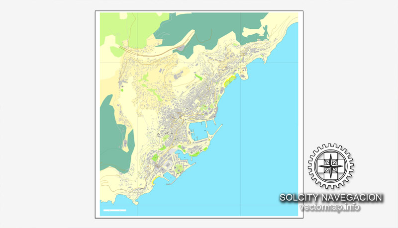
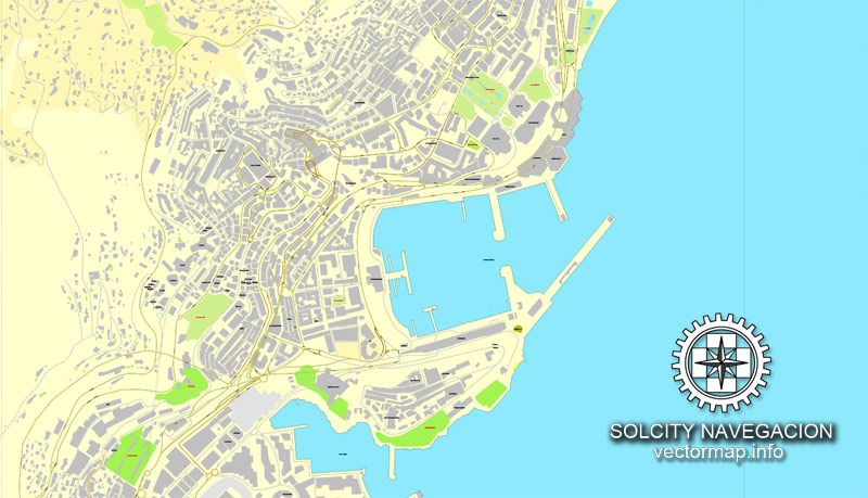
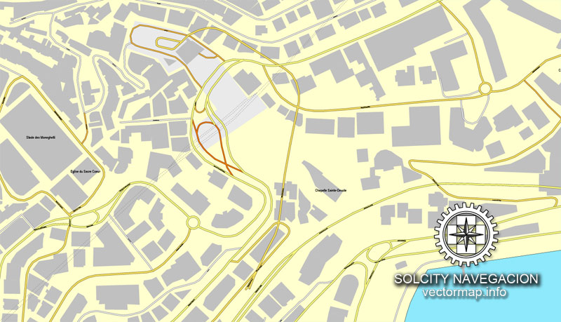
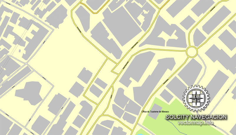
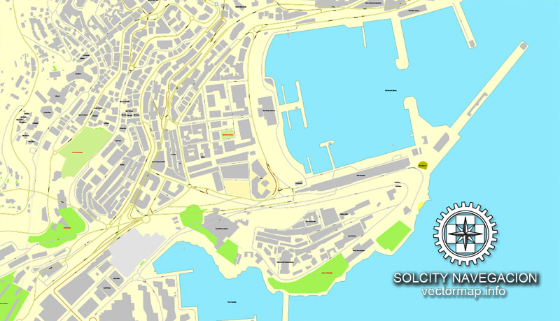
Monaco, France printable vector street City Plan map, full editable, Adobe PDF, full vector, scalable, editable, text format street names, 2 mb ZIP
All streets, All buildings. Map for design, print, arts, projects, presentations,
for architects, designers and builders.
You can edit this file by Adobe Illustrator, Adobe Acrobat, Corel Draw.
The most accurate and detailed map of the city.
DXF, DWG, CDR and other formats – on request, same price, please, contact
Monaco, France rue vecteur imprimable Plan Plan de ville, plein modifiable, Adobe PDF, vectoriel complet,,, noms évolutives rue format texte modifiable, 2 mb ZIP
Toutes les rues, tous les bâtiments. Carte de conception, d’impression, des arts, des projets, des présentations,
pour les architectes, les concepteurs et les constructeurs.
DXF, DWG, CDR et d’autres formats – sur demande, même prix, s’il vous plaît, contactez
Monaco.
This vector map of Monaco city is used as a basis for design, editing, and further printing.
This is the most detailed, exact map of Monaco city for high-quality printing and polygraphy. You can always clarify the map development date by contacting us.
For your convenience, all objects on Monaco vector city map are divided into layers. And the editing is very easy – colors, lines, etc.
You can easily add any objects needed (e.g. shops, salons, sale points, gas station or attraction) on any layer of Monaco vector map.
Monaco is a sovereign city-state, country and microstate on the French Riviera in Western Europe. France borders the country on three sides while the other side borders the Mediterranean Sea. Monaco is also located close to Italy, although it has no direct border.
One of the advantages of Monaco city vector maps of our production is the relevance of cartographic data, we constantly update all our products.
This vector map of Monaco city is used by:
designers, layout designers, printers, advertisers and architects. Our product – vector maps – is designed for further editing and printing in large formats – from @Wall format (a few meters) to A-0 and A-1, A-2, A-3.
The Monaco city map in vector format is used for design, urban planning, presentations and media visualizations.
The advertising and presentation map of Monaco city (usually the final designer marks the routes, and puts the client’s objects (shops, saloons, gas stations etc.)
The undoubted advantage is that people will NEVER throw out this advertising product – the map. In fact, as an advertising medium, a city map is the most “long-playing” of the well-known polygraphic advertising media, with the longest lifespan, and the maximum number of interactions with the customer.
For travelers, maps are sold at the airports and gas stations around the world. Often the source is our vector maps.
Take a look, who purchases our vector maps of Monaco city in “Our Clients and Friends” page – these are large and small companies, from super-brands like Volvo and Starbucks, to small design studios and printing houses.
It’s very easy to work with vector maps of Monaco city, even for a not very experienced designer who can turn on and off the map layers, add new objects, change the colors of fill and lines according to customer requirements.
The undoubted advantage of Monaco city vector maps in printing is an excellent and detailed visualization, when customer can expand a large paper map and instantly define his location, find a landmark, an object or address on map, unlike using the popular electronic formats of Google and Yandex maps for example.
Printable vector maps of Monaco city are much more convenient and efficient than any electronic maps on your smartphone, because ALL DETAILS are displayed in the entire space of Monaco city map.
Useful tips on working with vector maps of cities and countries in Adobe Illustrator.
«V» – launches the Selection tool (cursor, black arrow), which makes active any vector line.
«А» – launches the Direct Selection tool (white cursor), allows you to select curve elements and drag them to the desired place.
«R» – activates the Rotate tool, which helps you rotating selected objects around the center point by 360 degrees.
«E» – gives you the opportunity to use the Eraser tool and erase unnecessary parts.
«X» – switches between Fill and Stroke in the Tools section. Try to get used to this hot key and
you will quickly understand that you can’t live and work without it.
Guides are not limited to vertical and horizontal in Adobe Illustrator. You can also create a diagonal guide for example. Moreover, you can turn any contours into guides. Select the outline and go to View > Guides > Make Guides (Create Guides), or simply press Cmd/Ctrl + 5. You can also turn the guides back into an editable object. Go to menu, View > Guides > Unlock Guides (Release Guides), select the guide you want to edit and select View > Guides > Release Guides (Reset Guides), or just press Cmd/Ctrl + Option / Alt + 5).
You will probably want to change the color scheme used on our Monaco vector city map.
To quickly and effectively play with colors.
Of course, you can do it manually, all objects in our Monaco city vector map are divided according to types and layers, and you can easily change the color gamma of vector objects in groups and layers.
But there is more effective way of working with the whole VECTOR MAP of Monaco city and all layers:
The overview dialog «Edit colors»/«Repaint Graphic Object» (this dialog box name can change depending on the context):
If you have selected a part or a layer of Monaco city vector map and open the dialog box by clicking the icon in the Control panel, on the Samples palette or the Color Catalog, or if you choose Edit > Edit Colors> Repaint Graphic Object, then the «Repaint Graphic Object» dialog box appears, and you get access to «Assign» and «Edit» tabs.
If a picture or a map fragment is not selected, and you open the dialog box by clicking the icon in the Control panel, on the Samples palette or in the Color Catalog, the «Edit Colors» dialog box appears and you can only access the «Edit» tab.
Regardless of the name at the top of the dialog box, the right-hand side always displays the color group of the current document, as well as two default color groups: Print Color and Grayscale. These color groups can be selected and used any time.
Create and edit color groups of Monaco city vector map, and also assign colors using the «Edit Colors»/ а «Repaint Graphic Object» dialog box.
A. Creating and editing of a color group on the «Edit» tab
B. Assigning colors on the «Assign» tab
C. Select a group of colors from the «Color groups» list
The option «Repaint a graphic object» in the lower part of the dialog box allows you to preview the colors on a selected layer of Vector map, or a group of elements, and specify whether its colors will be redefined when the dialog box is closed.
The main areas of the dialog box are:
«Edit»
The «Edit» tab is designed to create a new or edit the existing color groups.
The harmony rules Menu and the Color Wheel are used to conduct experiments with color harmonies. The color wheel shows how colors are related in color harmony, and the color bars allow you to view and manipulate an individual color values. In addition, you can adjust the brightness, add and remove colors, save color groups and view colors on the selected Vector Map of Monaco city or a separated layers.
«Assign»
The «Assign» tab is used to view and control on how the original colors are replaced with colors from the color group like your corporate colors in the Vector Map of Monaco city.
The assign color ability is provided only if the entire map, layer or fragment is selected in the document. You can specify which of new colors replace the current colors, whether the spot colors should be preserved and how colors are replaced (for example, you can replace colors completely or changing the color tone while maintaining the brightness). The «Assign» tab allows you to redefine colors in the Vector Map of Monaco city, or in separate layers and fragments using the current color group or reducing the number of colors in the current Vector Map.
Color groups
Is a list of all saved color groups for current document (the same groups appear in the «Samples» palette). You can edit and delete the existing color groups, as well as creating a new ones using the list of “Color Groups” in the dialog box. All changes appear in the «Samples» palette.
The highlighted color group shows, which color group is currently edited.
Any color group can be selected and edited, or used to redefine the colors in the selected vector map of Monaco city, its fragments or elements.
Saving a color group adds this group to the specified list.
Opening the «Edit Colors»/«Repaint Graphic Object» dialog box.
Open the «Edit Colors»/«Repaint Graphic Object» dialog box using one of the following methods:
«Edit»> «Edit Colors»> «Repaint Graphic object» or «Repaint With Style».
Use these commands if you need to edit the colors in the selected vector map of Monaco city.
«Repaint Graphic object» button on the «Control» panel.
Use this button if you need to adjust colors of Monaco city vector map using the а «Repaint graphic object» dialog box.
The specified button is available if the selected vector map or its fragment contains two or more colors.
Note. This color editing method is convenient for global color adjustment in a vector map, if global colors were not used when creating a City Map of Monaco.
The «Edit colors» button or «Edit or apply colors» on the «Color Catalog» palette
Click this button if you need to edit colors on the «Color Catalog» palette or edit and then apply them to the selected Vector Map of Monaco city or its fragment.
The «Edit color group» button or «Edit or apply color group» on the «Samples» palette.
Click this button if you need to edit the colors in the specific color group or edit and apply them to the selected Vector Map of Monaco city or a group of its elements, for example, the whole layer “Streets and lines”. You can also double-click the color group in the Samples panel to open the dialog box.
If the map file is too large and your computer freezes or even can’t open it quickly:
1. Try to reduce the color resolution of the video card (display) to 256 colors while working with a large map.
2. Using Windows Task Manager, select all the application you don’t need, while working with map, just turn them off.
3. Launch Adobe Illustrator. (DO NOT OPEN the vector map file)
4. Start the Windows Task Manager using administrator rights > Find the “Illustrator” process > set the «real time» priority,
5. Open the file. When you see the LEGACY FONT popup window – click “OK” (do not update). You can restore the TEXT later.
6. Can also be useful: When file is opened – Edit > Settings > Basic Settings > disable smoothing. /// It looks scary, but works quickly)))
We recommend saving the file in Adobe Illustrator 10 version. It’s much more stable when working with VERY BIG size files.
Monaco has an area of 2.020 km2 (0.780 sq mi), making it the second-smallest country in the world after the Vatican. Its population was about 38,400 based on the last census of 2016. With 19,009 inhabitants per km², it is the most densely-populated sovereign state in the world. Monaco has a land border of 5.47 km (3.40 mi), a coastline of 3.83 km (2.38 mi), and a width that varies between 1,700 and 349 m (1,859 and 382 yd). The highest point in the country is a narrow pathway named Chemin des Révoires on the slopes of Mont Agel, in the Les Révoires Ward, which is 161 metres (528 feet) above sea level. Monaco’s most populous Quartier is Monte Carlo and the most populous Ward is Larvotto/Bas Moulins. Through land reclamation, Monaco’s land mass has expanded by 20 percent; in 2005, it had an area of only 1.974 km2 (0.762 sq mi). Monaco is known as a playground for the rich and famous, due to its tax laws. In 2014, it was noted about 30% of the population was made up of millionaires.
Monaco is a principality governed under a form of constitutional monarchy, with Prince Albert II as head of state. Although Prince Albert II is a constitutional monarch, he wields immense political power. The House of Grimaldi have ruled Monaco, with brief interruptions, since 1297. The official language is French, but Monégasque, Italian, and English are widely spoken and understood. The state’s sovereignty was officially recognized by the Franco-Monegasque Treaty of 1861, with Monaco becoming a full United Nations voting member in 1993. Despite Monaco’s independence and separate foreign policy, its defense is the responsibility of France. However, Monaco does maintain two small military units.
Economic development was spurred in the late 19th century with the opening of the country’s first casino, Monte Carlo, and a railway connection to Paris. Since then, Monaco’s mild climate, scenery, and gambling facilities have contributed to the principality’s status as a tourist destination and recreation centre for the rich. In more recent years, Monaco has become a major banking centre and has sought to diversify its economy into the services sector and small, high-value-added, non-polluting industries. The state has no income tax, low business taxes, and is well known for being a tax haven. It is also the host of the annual street circuit motor race Monaco Grand Prix, one of the original Grands Prix of Formula One. The principality has a club football team; AS Monaco, who have become French champions on multiple occasions.
Monaco is not formally a part of the European Union (EU), but it participates in certain EU policies, including customs and border controls. Through its relationship with France, Monaco uses the euro as its sole currency (prior to this it used the Monégasque franc). Monaco joined the Council of Europe in 2004. It is a member of the Organisation Internationale de la Francophonie (OIF).
Geography
Monaco is a sovereign city state, with five quartiers and ten wards, located on the French Riviera in Western Europe. It is bordered by France’s Alpes-Maritimes département on three sides, with one side bordering the Mediterranean Sea. Its center is about 16 km (9.9 mi) from Italy and only 13 km (8.1 mi) northeast of Nice, France. It has an area of 2.02 km2 (0.78 sq mi), or 202 hectares (500 acres), and a population of 38,400, making Monaco the second-smallest and the most densely populated country in the world. The country has a land border of only 5.47 km (3.40 mi), a coastline of 3.83 km (2.38 mi), a maritime claim that extends 22.2 kilometres (13.8 mi), and a width that varies between 1,700 and 349 m (5,577 and 1,145 ft).
The highest point in the country is at the access to the Patio Palace residential building on the Chemin des Révoires (ward Les Révoires) from the D6007 (Moyenne Corniche street) at 164.4 metres (539 feet) above sea level. The lowest point in the country is the Mediterranean Sea.
Saint-Jean is the longest flowing body of water, around 0.19 km (190 metres; 0.12 miles; 620 feet) in length, and Fontvieille is the largest lake, approximately 0.5 ha (5,000.00 m2; 1.24 acres; 53,819.55 sq ft) in area. Monaco’s most populated quartier is Monte Carlo, and the most populated ward is Larvotto/Bas Moulins.
After a recent expansion of Port Hercules, Monaco’s total area grew to 2.02 km2 (0.78 sq mi) or 202 hectares (500 acres); consequently, new plans have been approved to extend the district of Fontvieille by 0.08 km2 (0.031 sq mi) or 8 hectares (20 acres), with land reclaimed from the Mediterranean Sea. Current land reclamation projects include extending the district of Fontvieille. There are two ports in Monaco, Port Hercules and Port Fontvieille. Monaco’s only natural resource is fishing; with almost the entire country being an urban area, Monaco lacks any sort of commercial agriculture industry. There is a neighboring French port called Cap d’Ail that is near Monaco.
Small guide: How to work with the vector map?
You can: Mass select objects by type and color – for example, the objects type “building” (they are usually dark gray) – and remove them from the map, if you do not need them in your print or design project. You can also easily change the thickness of lines (streets), just bulk selection the road by the line color.
The streets are separated by type, for example, type “residential road” are usually white with a gray stroke. Highway usually orange with a brown or dark gray stroke.
It is easy to change the font of inscriptions, all or each individually. Also, just can be make and any other manipulation of objects on the vector map in Adobe illustrator format.
Important: All the proportions on the map are true, that is, the relative sizes of the objects are true, because Map is based on an accurate GPS projection, and It transated into the (usual for all) the Mercator projection.
You can easily change the color, stroke and fill of any object on the map, zoom without loss of quality Image Verification.
Select object

Bulk selection the same objects on the vector map

See the bulk selected objects on the vector map

Bulk delete buildungs from the vector map

Select residencial road (small street) on the vector map

Bulk selection the same lines (streets, roads) on the full map

Create fat lines of the streets on the vector maps (bulk action) 1

Create fat lines of the streets on the vector maps (bulk action) 2

Create fat lines of the streets on the vector maps (bulk action) 3

You can easily change the color, stroke and fill of any object on the map, zoom without loss of quality Image Verification.

 Author: Kirill Shrayber, Ph.D. FRGS
