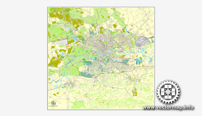
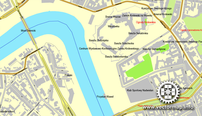
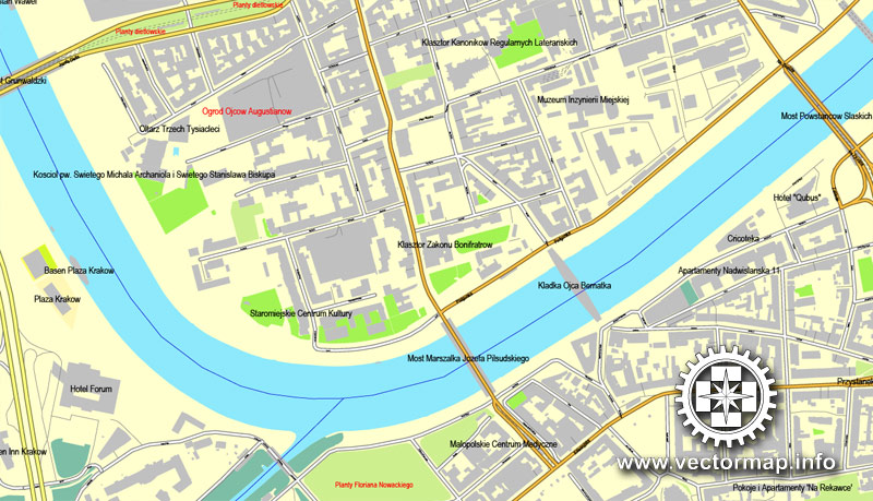
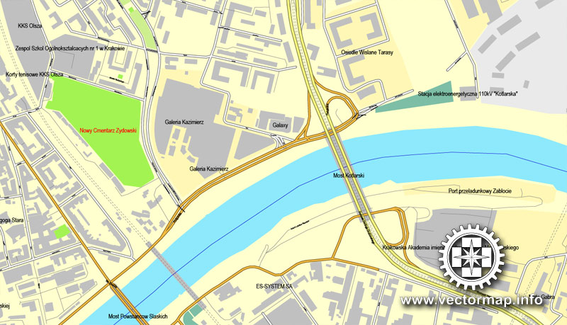
Krakow printable vector street map, Poland,, City Plan, fully editable, Adobe PDF, Royalty free, full vector, scalable, editable, text format of street names, 32 Mb ZIP.
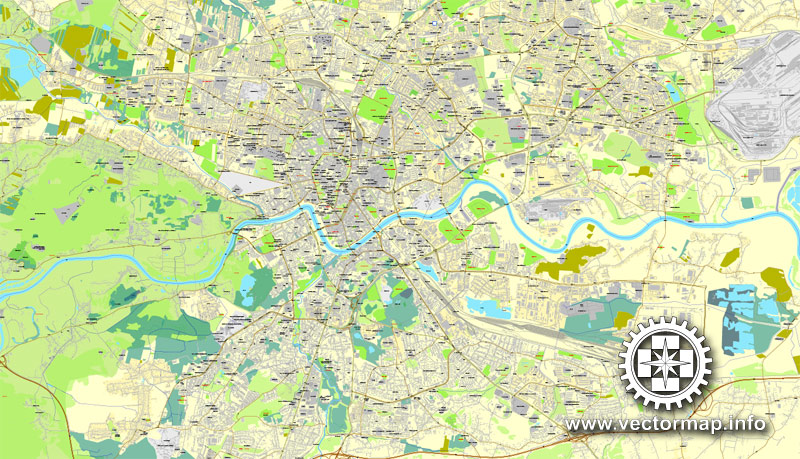
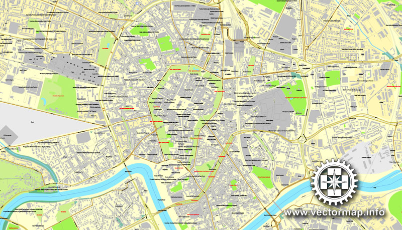
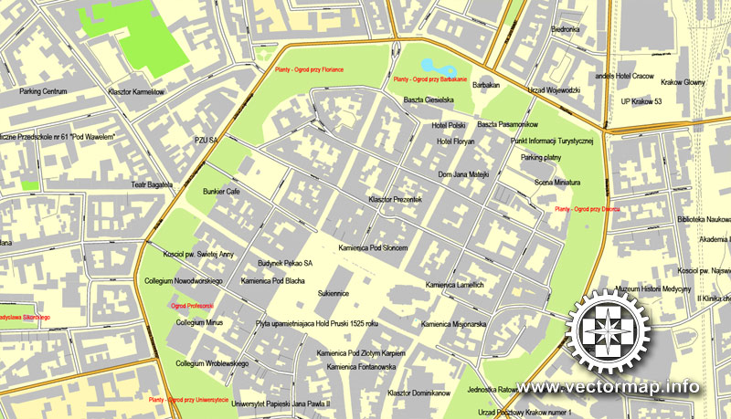
All streets, All buildings.
Map for design, print, arts, projects, presentations, for architects, designers and builders.
You can edit this file by Adobe Illustrator, Adobe Acrobat, Corel Draw.
The most accurate and detailed map of the city.
DXF, DWG, CDR and other formats – on request, same price, please, contact
Kraków, Polska, ulica wektor druku mapa, plan miasta, pełnej edycji, Adobe PDF, Nieodpłatnie pełne wektor, skalowalny edycji, formatowania tekstu nazwy ulic, 32 MB ZIP
Wszystkie ulice, wszystkie budynki.
Mapa do projektu, druk, sztuki, projekty, prezentacje, dla architektów, projektantów i budowniczych.
DXF, DWG, CDR i innych formatów – na żądanie, w tej samej cenie, prosimy o kontakt
See also: TERMS & CONDITIONS: SOFTWARE LICENSE AGREEMENT FOR DIGITAL CARTOGRAPHIC DATA
Krakow, Poland.
This vector map of Krakow is used as a basis for design, editing, and further printing.
This is the most detailed, exact map of Krakow for high-quality printing and polygraphy. You can always clarify the map development date by contacting us.
For your convenience, all objects on Krakow vector map are divided into layers. And the editing is very easy – colors, lines, etc.
You can easily add any objects needed (e.g. shops, salons, sale points, gas station or attraction) on any layer of Krakow vector map.
Krakow is the second largest and one of the oldest cities in Poland. Situated on the Vistula River in the Lesser Poland region, the city dates back to the 7th century. Kraków was the official capital of Poland until 1596 and has traditionally been one of the leading centres of Polish academic, economic, cultural and artistic life. Cited as one of Europe’s most beautiful cities, its Old Town was declared a UNESCO World Heritage Site.
One of the advantages of Krakow vector maps of our production is the relevance of cartographic data, we constantly update all our products.
This vector map of Krakow is used by:
designers, layout designers, printers, advertisers and architects. Our product – vector maps – is designed for further editing and printing in large formats – from @Wall format (a few meters) to A-0 and A-1, A-2, A-3.
Krakow map in vector format is used for design, urban planning, presentations and media visualizations.
Advertising and presentation map of Krakow (usually the final designer marks the routes, and puts the client’s objects (shops, saloons, gas stations etc.)
The undoubted advantage is that people will NEVER throw out this advertising product – the map. In fact, as an advertising medium, a map is the most “long-playing” of the well-known polygraphic advertising media, with the longest lifespan, and the maximum number of interactions with the customer.
For travelers, maps are sold at the airports and gas stations around the world. Often the source is our vector maps.
Take a look, who purchases our vector maps of Krakow in “Our Clients and Friends” page – these are large and small companies, from super-brands like Volvo and Starbucks, to small design studios and printing houses.
It’s very easy to work with vector maps of Krakow, even for a not very experienced designer who can turn on and off the map layers, add new objects, change the colors of fill and lines according to customer requirements.
The undoubted advantage of Krakow vector maps in printing is an excellent and detailed visualization, when customer can expand a large paper map and instantly define his location, find a landmark, an object or address on map, unlike using the popular electronic formats of Google and Yandex maps for example.
Printable vector maps of Krakow are much more convenient and efficient than any electronic maps on your smartphone, because ALL DETAILS are displayed in the entire space of Krakow map.
Useful tips on working with vector maps of cities and countries in Adobe Illustrator.
«V» – launches the Selection tool (cursor, black arrow), which makes active any vector line.
«А» – launches the Direct Selection tool (white cursor), allows you to select curve elements and drag them to the desired place.
«R» – activates the Rotate tool, which helps you rotating selected objects around the center point by 360 degrees.
«E» – gives you the opportunity to use the Eraser tool and erase unnecessary parts.
«X» – switches between Fill and Stroke in the Tools section. Try to get used to this hot key and
you will quickly understand that you can’t live and work without it.
Guides are not limited to vertical and horizontal in Adobe Illustrator. You can also create a diagonal guide for example. Moreover, you can turn any contours into guides. Select the outline and go to View > Guides > Make Guides (Create Guides), or simply press Cmd/Ctrl + 5. You can also turn the guides back into an editable object. Go to menu, View > Guides > Unlock Guides (Release Guides), select the guide you want to edit and select View > Guides > Release Guides (Reset Guides), or just press Cmd/Ctrl + Option / Alt + 5).
You will probably want to change the color scheme used on our Krakow vector map.
To quickly and effectively play with colors.
Of course, you can do it manually, all objects in our Krakow vector map are divided according to types and layers, and you can easily change the color gamma of vector objects in groups and layers.
But there is more effective way of working with the whole VECTOR MAP of Krakow and all layers:
The overview dialog «Edit colors»/«Repaint Graphic Object» (this dialog box name can change depending on the context):
If you have selected a part or a layer of Krakow vector map and open the dialog box by clicking the icon in the Control panel, on the Samples palette or the Color Catalog, or if you choose Edit > Edit Colors> Repaint Graphic Object, then the «Repaint Graphic Object» dialog box appears, and you get access to «Assign» and «Edit» tabs.
If a picture or a map fragment is not selected, and you open the dialog box by clicking the icon in the Control panel, on the Samples palette or in the Color Catalog, the «Edit Colors» dialog box appears and you can only access the «Edit» tab.
Regardless of the name at the top of the dialog box, the right-hand side always displays the color group of the current document, as well as two default color groups: Print Color and Grayscale. These color groups can be selected and used any time.
Create and edit color groups of Krakow vector map, and also assign colors using the «Edit Colors»/ а «Repaint Graphic Object» dialog box.
A. Creating and editing of a color group on the «Edit» tab
B. Assigning colors on the «Assign» tab
C. Select a group of colors from the «Color groups» list
The option «Repaint a graphic object» in the lower part of the dialog box allows you to preview the colors on a selected layer of Vector map, or a group of elements, and specify whether its colors will be redefined when the dialog box is closed.
The main areas of the dialog box are:
«Edit»
The «Edit» tab is designed to create a new or edit the existing color groups.
The harmony rules Menu and the Color Wheel are used to conduct experiments with color harmonies. The color wheel shows how colors are related in color harmony, and the color bars allow you to view and manipulate an individual color values. In addition, you can adjust the brightness, add and remove colors, save color groups and view colors on the selected Vector Map of Krakow or a separated layers.
«Assign»
The «Assign» tab is used to view and control on how the original colors are replaced with colors from the color group like your corporate colors in the Vector Map of Krakow.
The assign color ability is provided only if the entire map, layer or fragment is selected in the document. You can specify which of new colors replace the current colors, whether the spot colors should be preserved and how colors are replaced (for example, you can replace colors completely or changing the color tone while maintaining the brightness). The «Assign» tab allows you to redefine colors in the Vector Map of Krakow, or in separate layers and fragments using the current color group or reducing the number of colors in the current Vector Map.
Color groups
Is a list of all saved color groups for current document (the same groups appear in the «Samples» palette). You can edit and delete the existing color groups, as well as creating a new ones using the list of “Color Groups” in the dialog box. All changes appear in the «Samples» palette.
The highlighted color group shows, which color group is currently edited.
Any color group can be selected and edited, or used to redefine the colors in the selected vector map of Krakow, its fragments or elements.
Saving a color group adds this group to the specified list.
Opening the «Edit Colors»/«Repaint Graphic Object» dialog box.
Open the «Edit Colors»/«Repaint Graphic Object» dialog box using one of the following methods:
«Edit»> «Edit Colors»> «Repaint Graphic object» or «Repaint With Style».
Use these commands if you need to edit the colors in the selected vector map of Krakow.
«Repaint Graphic object» button on the «Control» panel.
Use this button if you need to adjust colors of Krakow vector map using the а «Repaint graphic object» dialog box.
The specified button is available if the selected vector map or its fragment contains two or more colors.
Note. This color editing method is convenient for global color adjustment in a vector map, if global colors were not used when creating a Map of Krakow.
The «Edit colors» button or «Edit or apply colors» on the «Color Catalog» palette
Click this button if you need to edit colors on the «Color Catalog» palette or edit and then apply them to the selected Vector Map of Krakow or its fragment.
The «Edit color group» button or «Edit or apply color group» on the «Samples» palette.
Click this button if you need to edit the colors in the specific color group or edit and apply them to the selected Vector Map of Krakow or a group of its elements, for example, the whole layer “Streets and lines”. You can also double-click the color group in the Samples panel to open the dialog box.
If the map file is too large and your computer freezes or even can’t open it quickly:
1. Try to reduce the color resolution of the video card (display) to 256 colors while working with a large map.
2. Using Windows Task Manager, select all the application you don’t need, while working with map, just turn them off.
3. Launch Adobe Illustrator. (DO NOT OPEN the vector map file)
4. Start the Windows Task Manager using administrator rights > Find the “Illustrator” process > set the «real time» priority,
5. Open the file. When you see the LEGACY FONT popup window – click “OK” (do not update). You can restore the TEXT later.
6. Can also be useful: When file is opened – Edit > Settings > Basic Settings > disable smoothing. /// It looks scary, but works quickly)))
We recommend saving the file in Adobe Illustrator 10 version. It’s much more stable when working with VERY BIG size files.
The city has grown from a Stone Age settlement to Poland’s second most important city. It began as a hamlet on Wawel Hill and was already being reported as a busy trading centre of Slavonic Europe in 965. With the establishment of new universities and cultural venues at the emergence of the Second Polish Republic in 1918 and throughout the 20th century, Kraków reaffirmed its role as a major national academic and artistic centre. The city has a population of about 770,000, with approximately 8 million additional people living within a 100 km (62 mi) radius of its main square.
After the invasion of Poland by the Nazi Regime at the start of World War II, the newly defined Distrikt Krakau (Kraków District) became the capital of Germany’s General Government. The Jewish population of the city was forced into a walled zone known as the Kraków Ghetto, from which they were sent to German extermination camps such as the nearby Auschwitz never to return, and the Nazi concentration camps like Płaszów.
In 1978, Karol Wojtyła, archbishop of Kraków, was elevated to the papacy as Pope John Paul II — the first Slavic pope ever, and the first non-Italian pope in 455 years. Also that year, UNESCO approved the first ever sites for its new World Heritage List, including the entire Old Town in inscribing Kraków’s Historic Centre. Kraków is classified as a global city with the ranking of high sufficiency by GaWC. Its extensive cultural heritage across the epochs of Gothic, Renaissance and Baroque architecture includes the Wawel Cathedral and the Royal Castle on the banks of the Vistula, the St. Mary’s Basilica, Saints Peter and Paul Church and the largest medieval market square in Europe, the Rynek Główny. Kraków is home to Jagiellonian University, one of the oldest universities in the world and traditionally Poland’s most reputable institution of higher learning.
In 2000, Kraków was named European Capital of Culture. In 2013 Kraków was officially approved as a UNESCO City of Literature. The city hosted the World Youth Day in July 2016.
Kraków lies in the southern part of Poland, on the Vistula River, in a valley at the foot of the Carpathian Mountains, 219 m (719 ft) above sea level; halfway between the Jurassic Rock Upland (Polish: Jura Krakowsko-Częstochowska) to the north, and the Tatra Mountains 100 km (62 mi) to the south, constituting the natural border with Slovakia and the Czech Republic; 230 km (143 mi) west from the border with Ukraine.
There are five nature reserves in Kraków, with a combined area of ca. 48.6 hectares (120 acres). Due to their ecological value, these areas are legally protected. The western part of the city, along its northern and north-western side, borders an area of international significance known as the Jurassic Bielany-Tyniec refuge. The main motives for the protection of this area include plant and animal wildlife and the area’s geomorphological features and landscape. Another part of the city is located within the ecological ‘corridor’ of the Vistula River valley. This corridor is also assessed as being of international significance as part of the Pan-European ecological network. The city centre is situated on the left (northern) bank of the river.
Small guide: How to work with the vector map?
You can: Mass select objects by type and color – for example, the objects type “building” (they are usually dark gray) – and remove them from the map, if you do not need them in your print or design project. You can also easily change the thickness of lines (streets), just bulk selection the road by the line color.
The streets are separated by type, for example, type “residential road” are usually white with a gray stroke. Highway usually orange with a brown or dark gray stroke.
All objects are divided by types: different types of roads and streets, polygons of buildings, landfills, urban areas, parks and more other.
It is easy to change the font of inscriptions, all or each individually. Also, just can be make and any other manipulation of objects on the vector map in Adobe illustrator format.
Important: All the proportions on the map are true, that is, the relative sizes of the objects are true, because Map is based on an accurate GPS projection, and It transated into the (usual for all) the Mercator projection.
You can easily change the color, stroke and fill of any object on the map, zoom without loss of quality Image Verification.
Select object

Bulk selection the same objects on the vector map

See the bulk selected objects on the vector map

Bulk delete buildungs from the vector map

Select residencial road (small street) on the vector map

Bulk selection the same lines (streets, roads) on the full map

Create fat lines of the streets on the vector maps (bulk action) 1

Create fat lines of the streets on the vector maps (bulk action) 2

Create fat lines of the streets on the vector maps (bulk action) 3

You can easily change the color, stroke and fill of any object on the map, zoom without loss of quality Image Verification.
Kraków, also Cracow or Krakow, is the second largest and one of the oldest cities in Poland. Situated on the Vistula River (Polish: Wisła) in the Lesser Poland region, the city dates back to the 7th century. Kraków has traditionally been one of the leading centres of Polish academic, cultural, and artistic life and is one of Poland’s most important economic hubs. It was the capital of the Crown of the Kingdom of Poland from 1038 to 1569; the Polish–Lithuanian Commonwealth from 1569 to 1795; the Free City of Kraków from 1815 to 1846; the Grand Duchy of Cracow from 1846 to 1918; and Kraków Voivodeship from the 14th century to 1998. It has been the capital of Lesser Poland Voivodeship since 1999.
The city has grown from a Stone Age settlement to Poland’s second most important city. It began as a hamlet on Wawel Hill and was already being reported as a busy trading centre of Slavonic Europe in 965. With the establishment of new universities and cultural venues at the emergence of the Second Polish Republic in 1918 and throughout the 20th century, Kraków reaffirmed its role as a major national academic and artistic centre. The city has a population of approximately 760,000, with approximately 8 million additional people living within a 100 km (62 mi) radius of its main square.
After the invasion of Poland at the start of World War II, Kraków street map became the capital of Germany’s General Government. The Jewish population of the city was forced into a walled zone known as the Kraków Ghetto, from which they were sent to German extermination camps such as the nearby Auschwitz never to return, and the Nazi concentration camps like Płaszów.
In 1978, Karol Wojtyła, archbishop of Kraków, was elevated to the papacy as Pope John Paul II — the first Slavic pope ever, and the first non-Italian pope in 455 years. Also that year, UNESCO approved the first ever sites for its new World Heritage List, including the entire Old Town in inscribing Cracow’s Historic Centre. Kraków is classified as a Gamma- global city by GaWC. Cited as one of Europe’s most beautiful cities, as well as one of the most unique destinations in the world, its extensive cultural heritage across the epochs of Gothic, Renaissance and Baroque architecture includes the Wawel Cathedral and the Royal Castle on the banks of the Vistula river, the St. Mary’s Basilica and the largest medieval market square in Europe, the Rynek Główny. Kraków is home to Jagiellonian University, one of the oldest universities in the world and traditionally Poland’s most reputable institution of higher learning.
In 2000, Kraków was named European Capital of Culture. In 2013 Kraków was officially approved as a UNESCO City of Literature. The city hosted the World Youth Day in July 2016.
Geography of Kraków
Zalew Zakrzówek, a flooded quarry within the city limits of Kraków
Kraków lies in the southern part of Poland, on the Vistula River, in a valley at the foot of the Carpathian Mountains, 219 m (719 ft) above sea level; halfway between the Jurassic Rock Upland (Polish: Jura Krakowsko-Częstochowska) to the north, and the Tatra Mountains 100 km (62 mi) to the south, constituting the natural border with Slovakia and the Czech Republic; 230 km (143 mi) west from the border with Ukraine. There are five nature reserves in Kraków printable map, with a combined area of ca. 48.6 hectares (120 acres). Due to their ecological value, these areas are legally protected. The western part of the city, along its northern and north-western side, borders an area of international significance known as the Jurassic Bielany-Tyniec refuge. The main motives for the protection of this area include plant and animal wildlife and the area’s geomorphological features and landscape. Another part of the city is located within the ecological ‘corridor’ of the Vistula River valley. This corridor is also assessed as being of international significance as part of the Pan-European ecological network. The city centre is situated on the left (northern) bank of the river.
Source
Kraków (łac. Cracovia) – miasto położone w południowej Polsce nad Wisłą, drugie w kraju pod względem liczby mieszkańców[1][5] i powierzchni[1], stolica Polski do 1795 r. i miasto koronacyjne oraz nekropolia królów Polski, od 1000 roku nieprzerwanie stolica diecezji krakowskiej (jednej z pięciu w ówczesnej Polsce), a od 1925 archidiecezji i metropolii, od odzyskania niepodległości w 1918 r. miasto wojewódzkie (od 1998 r. siedziba władz województwa małopolskiego), jest także centralnym ośrodkiem metropolitalnym aglomeracji krakowskiej i Krakowskiego Obszaru Metropolitalnego. W zapisach historycznych Kraków editable map jest uznawany za główne miasto historycznej Małopolski. Leży na obszarze Bramy Krakowskiej, Niecki Nidziańskiej i Pogórza Zachodniobeskidzkiego.
W Krakowie znajdują się główne siedziby m.in.: Polskiej Akademii Umiejętności, Narodowego Centrum Nauki, Polskiego Towarzystwa Promieniowania Synchrotronowego[6], Krajowej Szkoły Sądownictwa i Prokuratury[7], dowództwa Sił Specjalnych RP będące jednocześnie jednym z kilku dowództw sił specjalnych NATO[8][9], Centrum Operacji Lądowych – Dowództwa Komponentu Lądowego[10], Polskiego Związku Narciarskiego[11]. W mieście działają placówki kulturalne o znaczeniu i statusie narodowym m.in. Narodowy Stary Teatr, Muzeum Narodowe, Panteon Narodowy[12], Archiwum Narodowe[13], Biblioteka Jagiellońska, Instytut Książki[14], Centrum Operacji Specjalnych[15], Narodowe Centrum Rugby[16].
Miasto na prawach powiatu pełni funkcję centrum administracyjnego, kulturalnego, edukacyjnego, naukowego, gospodarczego, usługowego i turystycznego. Kraków jest drugim co do wielkości, po Warszawie, rynkiem nowoczesnej powierzchni biurowej[17], a także jednym z kluczowych węzłów kolejowych w Polsce. W Balicach pod Krakowem znajduje się drugi co do liczby obsługiwanych pasażerów rocznie port lotniczy w Polsce[18], a który ponownie obsługiwał będzie połączenia transatlantyckie.[19]
Toponimia of Kraków
Za pełny tytuł miasta przedstawia się Stołeczne Królewskie Miasto Kraków. Pomimo coraz większej kosmopolityzacji, Kraków pozostaje nadal depozytariuszem polskiego godła[styl do poprawy]. Jako jedyne miasto w Polsce ma prawo używać w herbie godła Państwa Polskiego. Taka możliwość, według symboliki heraldycznej, przysługuje jedynie miastom i regionom stołecznym.
Autorem pierwszego źródła piśmiennego, w którym w 966 pojawia się Kraków city map jest Ibrahim ibn Jakub. W dokumentach łacińskich w 973 występuje w formie Cracoua.
Językoznawca Jerzy Nalepa twierdzi, że rdzeń krak oznacza odgałęzienie rzeczne.
Według legendy zapisanej w końcu XII wieku przez Wincentego Kadłubka nazwa Krakowa pochodzi od imienia księcia Kraka, natomiast w legendach czeskich występuje postać księcia Kroka.
Do historycznej funkcji Krakowa odnosi się jego pełna nazwa – Stołeczne Królewskie Miasto Kraków usankcjonowana prawnie przez Radę Ministrów, jak i wcześniej przez naczelne władze państwowe II Rzeczypospolitej, które używały tej nazwy w swoich aktach prawnych. Również nazwy skróconej, tj.: st. król. miasto Kraków, st.kr. miasto Kraków vector map albo stoł. król. miasto Kraków. Niektóre z tych aktów prawnych obowiązują do dzisiaj. Na arenie międzynarodowej Kraków postrzegany jest jako „duchowe i naukowe serce Polski”
Source
See more Poland cities vector maps for printing and editing
For example: Warsaw street map printable, Poland
Krakow vector map for printing, Poland
Poznan city editable map, Poland

 Author: Kirill Shrayber, Ph.D. FRGS

