Odense, Denmark printable vector street full City Plan map, full editable, Adobe Illustrator, full vector, scalable, editable, text format street names, 3,6 mb ZIP
All streets, all buildings. Map for design, print, arts, projects.
PDF, DXF and other formats – on demand, same price, please, contact
Odense, Danmark printable vektor gade fuld By Plan kort, fuld redigerbare, Adobe Illustrator, fuld vektor, skalerbare, redigerbare, tekst format gadenavne, 3,6 mb ZIP
Alle gader, alle bygninger. Kort for design, print, kunst, projekter.
PDF, DXF og andre formater – on demand, samme pris, bedes du kontakte
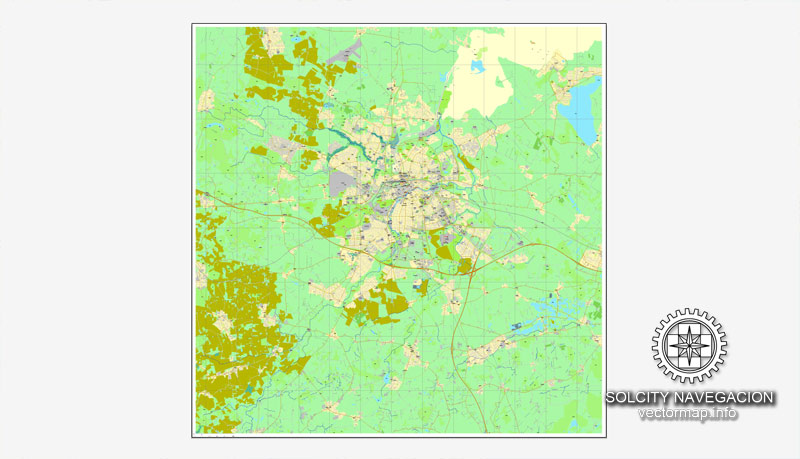
Odense, Denmark.
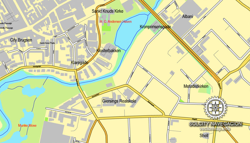
This vector map of Odense is used as a basis for design, editing, and further printing.
This is the most detailed, exact map of Odense for high-quality printing and polygraphy. You can always clarify the map development date by contacting us.
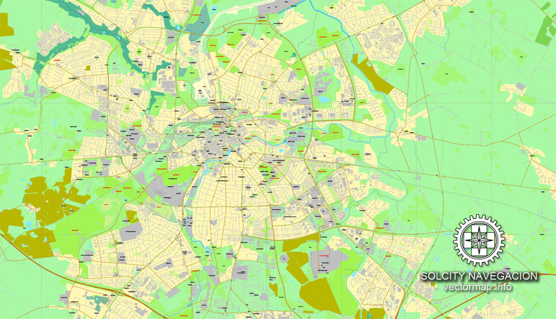
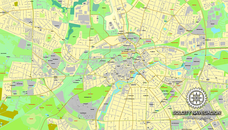
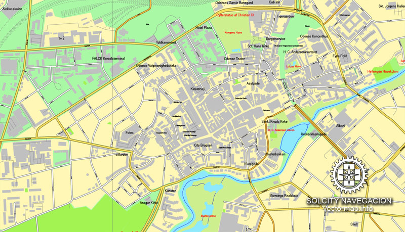
For your convenience, all objects on Odense vector map are divided into layers. And the editing is very easy – colors, lines, etc.
You can easily add any objects needed (e.g. shops, salons, sale points, gas station or attraction) on any layer of Odense vector map.
Odense is the third-largest city in Denmark. It has a population of 178,210 as of January 2016, and is the main city of the island of Funen. By road, Odense is located 45 kilometres (28 mi) north of Svendborg, 144 kilometres (89 mi) to the south of Aarhus and 167 kilometres (104 mi) to the southwest of Copenhagen. The city is the seat of Odense Municipality and was the seat of Odense County until 1970, and Funen County from 1970 until 1 January 2007, when Funen County became part of the Region of Southern Denmark. Odense has close associations with Hans Christian Andersen who is remembered above all for his fairy tales. He was born in the city in 1805 and spent his childhood years there.
One of the advantages of Odense vector maps of our production is the relevance of cartographic data, we constantly update all our products.
This vector map of Odense is used by:
designers, layout designers, printers, advertisers and architects. Our product – vector maps – is designed for further editing and printing in large formats – from @Wall format (a few meters) to A-0 and A-1, A-2, A-3.
Odense map in vector format is used for design, urban planning, presentations and media visualizations.
Advertising and presentation map of Odense (usually the final designer marks the routes, and puts the client’s objects (shops, saloons, gas stations etc.)
The undoubted advantage is that people will NEVER throw out this advertising product – the map. In fact, as an advertising medium, a map is the most “long-playing” of the well-known polygraphic advertising media, with the longest lifespan, and the maximum number of interactions with the customer.
For travelers, maps are sold at the airports and gas stations around the world. Often the source is our vector maps.
Take a look, who purchases our vector maps of Odense in “Our Clients and Friends” page – these are large and small companies, from super-brands like Volvo and Starbucks, to small design studios and printing houses.
It’s very easy to work with vector maps of Odense, even for a not very experienced designer who can turn on and off the map layers, add new objects, change the colors of fill and lines according to customer requirements.
The undoubted advantage of Odense vector maps in printing is an excellent and detailed visualization, when customer can expand a large paper map and instantly define his location, find a landmark, an object or address on map, unlike using the popular electronic formats of Google and Yandex maps for example.
Printable vector maps of Odense are much more convenient and efficient than any electronic maps on your smartphone, because ALL DETAILS are displayed in the entire space of Odense map.
Useful tips on working with vector maps of cities and countries in Adobe Illustrator.
«V» – launches the Selection tool (cursor, black arrow), which makes active any vector line.
«А» – launches the Direct Selection tool (white cursor), allows you to select curve elements and drag them to the desired place.
«R» – activates the Rotate tool, which helps you rotating selected objects around the center point by 360 degrees.
«E» – gives you the opportunity to use the Eraser tool and erase unnecessary parts.
«X» – switches between Fill and Stroke in the Tools section. Try to get used to this hot key and
you will quickly understand that you can’t live and work without it.
Guides are not limited to vertical and horizontal in Adobe Illustrator. You can also create a diagonal guide for example. Moreover, you can turn any contours into guides. Select the outline and go to View > Guides > Make Guides (Create Guides), or simply press Cmd/Ctrl + 5. You can also turn the guides back into an editable object. Go to menu, View > Guides > Unlock Guides (Release Guides), select the guide you want to edit and select View > Guides > Release Guides (Reset Guides), or just press Cmd/Ctrl + Option / Alt + 5).
You will probably want to change the color scheme used on our Odense vector map.
To quickly and effectively play with colors.
Of course, you can do it manually, all objects in our Odense vector map are divided according to types and layers, and you can easily change the color gamma of vector objects in groups and layers.
But there is more effective way of working with the whole VECTOR MAP of Odense and all layers:
The overview dialog «Edit colors»/«Repaint Graphic Object» (this dialog box name can change depending on the context):
If you have selected a part or a layer of Odense vector map and open the dialog box by clicking the icon in the Control panel, on the Samples palette or the Color Catalog, or if you choose Edit > Edit Colors> Repaint Graphic Object, then the «Repaint Graphic Object» dialog box appears, and you get access to «Assign» and «Edit» tabs.
If a picture or a map fragment is not selected, and you open the dialog box by clicking the icon in the Control panel, on the Samples palette or in the Color Catalog, the «Edit Colors» dialog box appears and you can only access the «Edit» tab.
Regardless of the name at the top of the dialog box, the right-hand side always displays the color group of the current document, as well as two default color groups: Print Color and Grayscale. These color groups can be selected and used any time.
There has been human settlement in the Odense area for over 4,000 years, although the name was not mentioned in writing until 988, and by 1070, it had already grown into a thriving city. Canute IV of Denmark, generally considered to be the last Viking king, was murdered by unruly peasants in Odense’s St Alban’s Priory on 10 July 1086. Although the city was burned in 1249 following a royal rivalry, it quickly recovered and flourished as a centre of commerce in the Middle Ages. After a period of decline, large-scale plans for development were made during the 18th century, which led to the rebuilding of Odense Palace and the building of a canal to the Port of Odense, facilitating trade. In 1865, one of the largest railway terminals in Denmark was built, further increasing the population and commerce, and by 1900, Odense had reached a population of 35,000. Odense’s Odinstårnet was one of the tallest towers in Europe when built in 1935 but was destroyed by the Nazis during World War II. The University of Southern Denmark was established in 1966.
Create and edit color groups of Odense vector map, and also assign colors using the «Edit Colors»/ а «Repaint Graphic Object» dialog box.
A. Creating and editing of a color group on the «Edit» tab
B. Assigning colors on the «Assign» tab
C. Select a group of colors from the «Color groups» list
The option «Repaint a graphic object» in the lower part of the dialog box allows you to preview the colors on a selected layer of Vector map, or a group of elements, and specify whether its colors will be redefined when the dialog box is closed.
The main areas of the dialog box are:
«Edit»
The «Edit» tab is designed to create a new or edit the existing color groups.
The harmony rules Menu and the Color Wheel are used to conduct experiments with color harmonies. The color wheel shows how colors are related in color harmony, and the color bars allow you to view and manipulate an individual color values. In addition, you can adjust the brightness, add and remove colors, save color groups and view colors on the selected Vector Map of Odense or a separated layers.
«Assign»
The «Assign» tab is used to view and control on how the original colors are replaced with colors from the color group like your corporate colors in the Vector Map of Odense.
The assign color ability is provided only if the entire map, layer or fragment is selected in the document. You can specify which of new colors replace the current colors, whether the spot colors should be preserved and how colors are replaced (for example, you can replace colors completely or changing the color tone while maintaining the brightness). The «Assign» tab allows you to redefine colors in the Vector Map of Odense, or in separate layers and fragments using the current color group or reducing the number of colors in the current Vector Map.
Color groups
Is a list of all saved color groups for current document (the same groups appear in the «Samples» palette). You can edit and delete the existing color groups, as well as creating a new ones using the list of “Color Groups” in the dialog box. All changes appear in the «Samples» palette.
The highlighted color group shows, which color group is currently edited.
Any color group can be selected and edited, or used to redefine the colors in the selected vector map of Odense, its fragments or elements.
Saving a color group adds this group to the specified list.
Opening the «Edit Colors»/«Repaint Graphic Object» dialog box.
Open the «Edit Colors»/«Repaint Graphic Object» dialog box using one of the following methods:
«Edit»> «Edit Colors»> «Repaint Graphic object» or «Repaint With Style».
Use these commands if you need to edit the colors in the selected vector map of Odense.
«Repaint Graphic object» button on the «Control» panel.
Use this button if you need to adjust colors of Odense vector map using the а «Repaint graphic object» dialog box.
The specified button is available if the selected vector map or its fragment contains two or more colors.
Note. This color editing method is convenient for global color adjustment in a vector map, if global colors were not used when creating a Map of Odense.
The «Edit colors» button or «Edit or apply colors» on the «Color Catalog» palette
Click this button if you need to edit colors on the «Color Catalog» palette or edit and then apply them to the selected Vector Map of Odense or its fragment.
The «Edit color group» button or «Edit or apply color group» on the «Samples» palette.
Click this button if you need to edit the colors in the specific color group or edit and apply them to the selected Vector Map of Odense or a group of its elements, for example, the whole layer “Streets and lines”. You can also double-click the color group in the Samples panel to open the dialog box.
If the map file is too large and your computer freezes or even can’t open it quickly:
1. Try to reduce the color resolution of the video card (display) to 256 colors while working with a large map.
2. Using Windows Task Manager, select all the application you don’t need, while working with map, just turn them off.
3. Launch Adobe Illustrator. (DO NOT OPEN the vector map file)
4. Start the Windows Task Manager using administrator rights > Find the “Illustrator” process > set the «real time» priority,
5. Open the file. When you see the LEGACY FONT popup window – click “OK” (do not update). You can restore the TEXT later.
6. Can also be useful: When file is opened – Edit > Settings > Basic Settings > disable smoothing. /// It looks scary, but works quickly)))
We recommend saving the file in Adobe Illustrator 10 version. It’s much more stable when working with VERY BIG size files.
In the present day, Odense remains the commercial hub of Funen, and has a notable shopping district with a diversity of stores. Several major industries are located in the city including the Albani Brewery and GASA, Denmark’s major dealer in vegetables, fruits and flowers. The city is home to Odense Palace, erected by King Frederik IV who died there in 1730, the Odense Theatre, the Odense Symphony Orchestra, and the Hans Christian Andersen Museum, situated in the house that was the birthplace of Hans Christian Andersen. In sports, Odense has a number of football clubs including OB, BM, B1909, and B1913, the Odense Bulldogs professional ice hockey team, and the city also hosts the H.C. Andersen Marathon. Odense is served by Hans Christian Andersen Airport and Odense station, which lies on the line between Copenhagen and the Jutland peninsula.
Small guide: How to work with the vector map?
You can: Mass select objects by type and color – for example, the objects type “building” (they are usually dark gray) – and remove them from the map, if you do not need them in your print or design project. You can also easily change the thickness of lines (streets), just bulk selection the road by the line color.
The streets are separated by type, for example, type “residential road” are usually white with a gray stroke. Highway usually orange with a brown or dark gray stroke.
It is easy to change the font of inscriptions, all or each individually. Also, just can be make and any other manipulation of objects on the vector map in Adobe illustrator format.
Important: All the proportions on the map are true, that is, the relative sizes of the objects are true, because Map is based on an accurate GPS projection, and It transated into the (usual for all) the Mercator projection.
You can easily change the color, stroke and fill of any object on the map, zoom without loss of quality Image Verification.
Select object

Bulk selection the same objects on the vector map

See the bulk selected objects on the vector map

Bulk delete buildungs from the vector map

Select residencial road (small street) on the vector map

Bulk selection the same lines (streets, roads) on the full map

Create fat lines of the streets on the vector maps (bulk action) 1

Create fat lines of the streets on the vector maps (bulk action) 2

Create fat lines of the streets on the vector maps (bulk action) 3

You can easily change the color, stroke and fill of any object on the map, zoom without loss of quality Image Verification.

 Author: Kirill Shrayber, Ph.D. FRGS
