Extended Description of the Vector Map
Norway is located in the north of Europe, in the western part of the Scandinavian Peninsula. A third of the country lies beyond the Arctic Circle. The country shares borders with Russia, Sweden, and Finland. In the north, the coast of Norway is washed by the Barents Sea, in the west – the Norwegian and Northern Seas, in the south the Skagerrak Strait separates Norway from Denmark. Norway owns the Svalbard archipelago with the Bear Island in the Arctic Ocean, the island of Jan Mayen in the North Atlantic, as well as the island of Bouvet off the coast of Antarctica and more than 50 thousand small islands.
State system: constitutional monarchy
Capital: Oslo
Population: about 4.5 million people. The main part of the population is Norwegian, about 94% of them live here, as well as 2.5% of the inhabitants are Swedes.
Language: Norwegian
Religion: Christianity is practiced by the majority of the population. 93% of Christians are evangelicals.
Currency: Norwegian Krona/NOK
Norway is an amazing place with fabulous nature. Thousands of bays and fjords surround the coast of Norway, majestic mountains covered with forests, glaciers, rivers, and lakes make the country picturesque and unique. Norway is located in the north of Europe, but the climate here is quite favorable – cool summers and mild winters. Norway is considered a prosperous country in terms of economic development.
There are a great many ski resorts in Norway. After all, this northern country gave a start to the development of skiing. The resort has all the conditions for living and recreation. The ski resorts are equipped with all the necessary equipment and are perfect for families with children. On the territory of the ski base, there are special children’s areas for skiing. If your child does not yet know how to skate, then he can learn the skill at a skating school. Well, if your child’s age is such that it is still too early for him to get up on skis, then a nursery is provided. While your child is under the supervision of a babysitter, you can safely go skiing. This country is just a paradise for fishermen. Many tourists come to the country just to go fishing.
This region has a huge number of rivers, lakes, and bays that are rich in wildlife. Here, even a beginner can expect a rich catch. At the fishing base, you can rent all the necessary equipment for fishing. The fishing guide will teach you the skills of fishing, butchering, and storing fish. And on your return from fishing, your catch will be prepared for you according to a special recipe. After all, fish dishes are the basis of Norwegian cuisine.
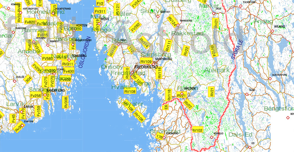
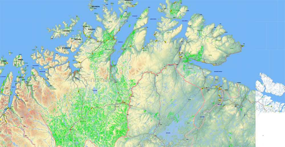
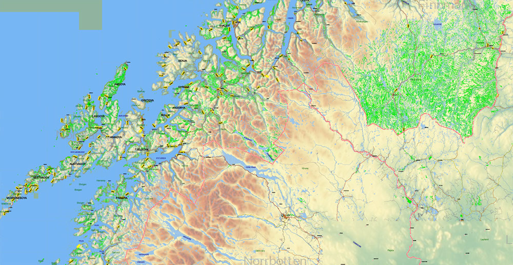
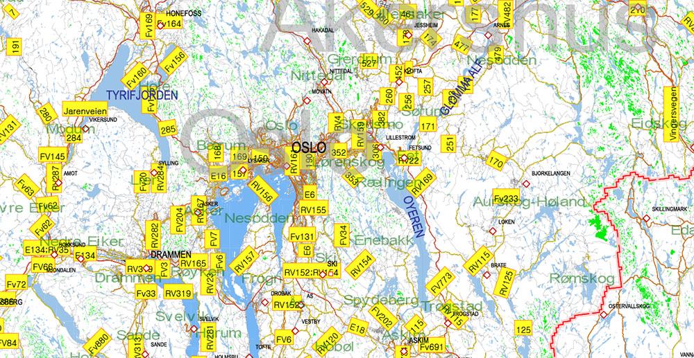
Printable Vector Map of Norway All Roads + Relief + Admin areas (provinces and counties) full editable Adobe Illustrator Map in layers, in 1 file, scalable, 741 MB ZIP (2,628 GB!!!! size in decompressed file, USE POWERFULL MACHINE!)
All streets and roads, All Cities and Towns, Counties, Provinces, Relief layer (raster HR). Map for design, printing, arts, projects, presentations, for architects, designers, and builders, business, logistics.
Excluded: Svalbard (Spitsbergen)
For Editing and High-Quality Printing, Royalty free
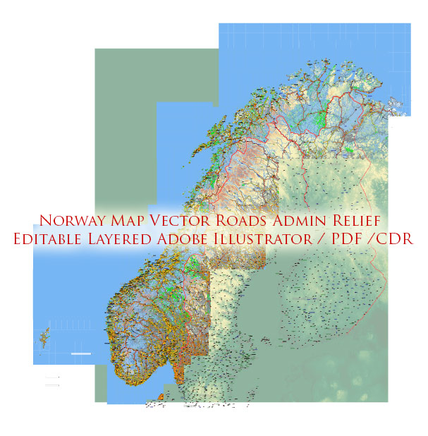
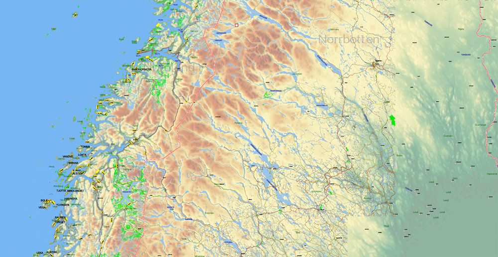
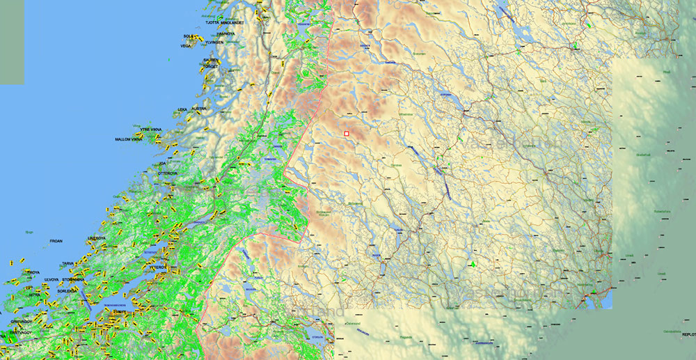
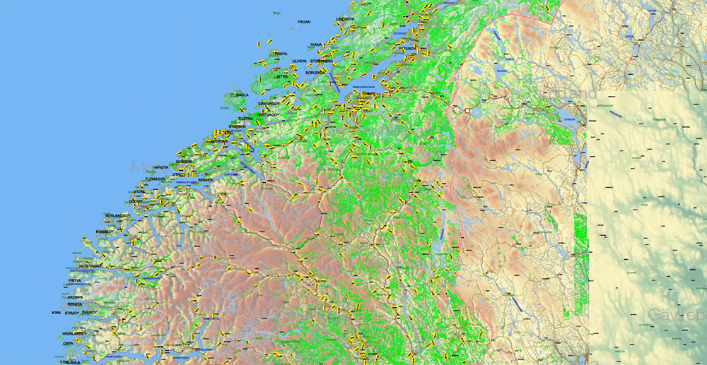
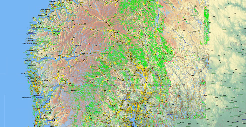
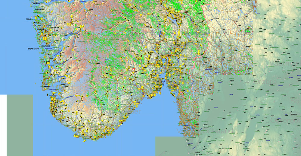
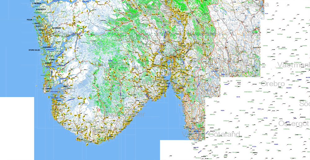
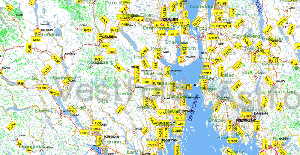
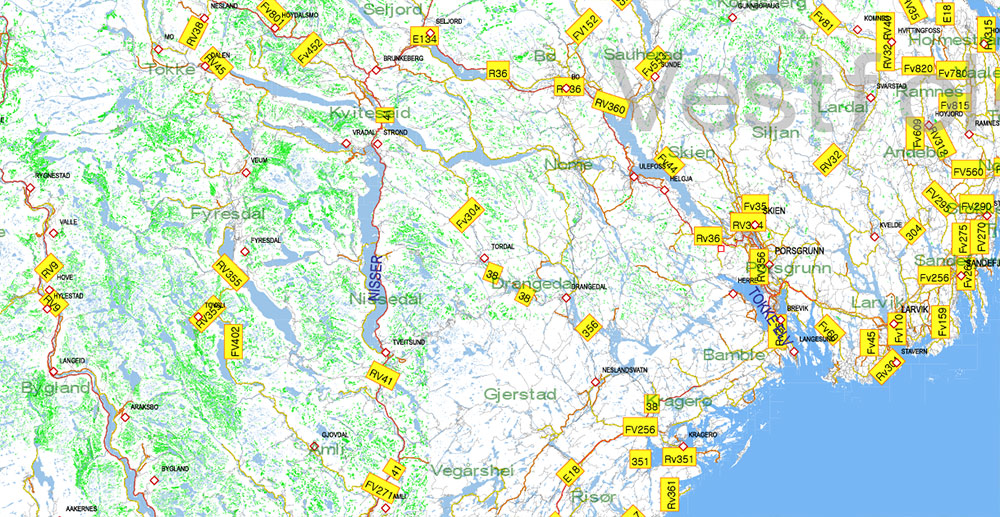
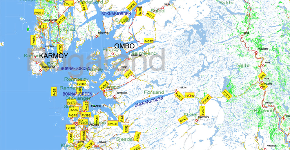
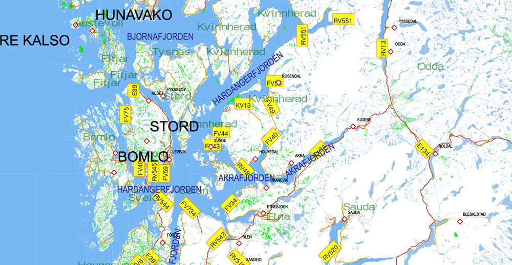
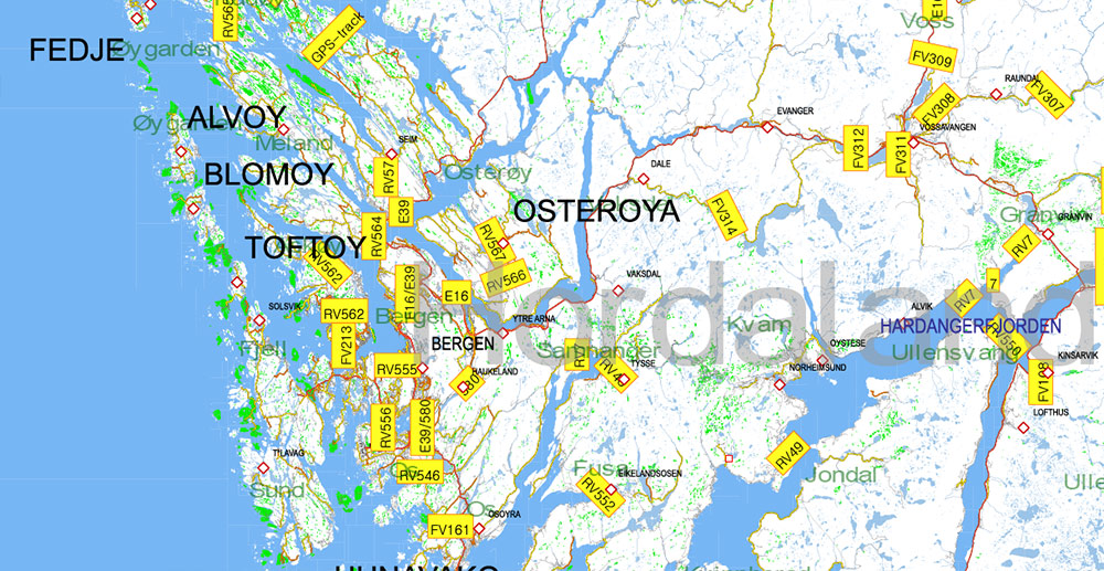
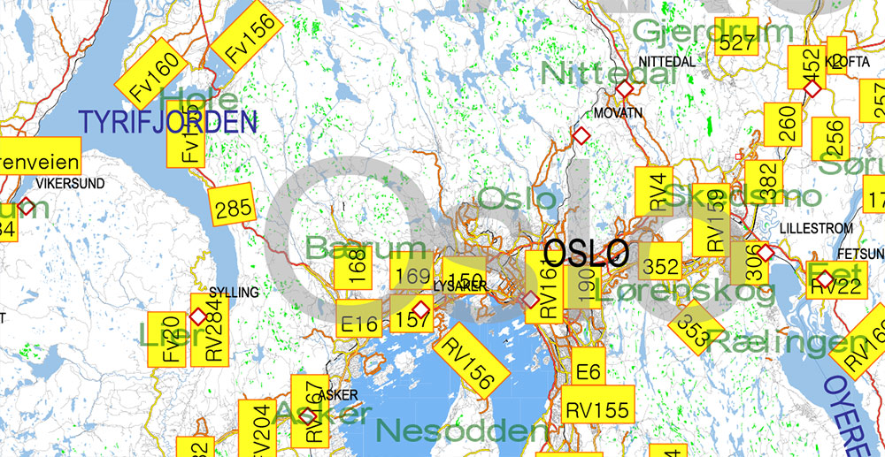
Norway Map Vector Full Extra High Detailed 01 (all roads) in ONE file + Relief + Admin Areas editable Adobe Illustrator in layers
Layers list:
- Names of Cities and Towns
- Numbers of roads
- Names of Water objects
- Names of Provinces
- Names of Counties
- Points of the Cities and Towns
- Major Roads – Highways
- Minor Roads and streets
- Country Borders
- Railroads and Aeroway lines
- Water objects (rivers, lakes, ponds, swamps, reefs)
- Waterways
- Sea
- Country Areas
- Provinces Areas
- Relief (topo raster image HR TIFF 150 DPI)
Norway Map Vector Full Extra High Detailed 01 (all roads) in ONE file + Relief + Admin Areas editable Adobe Illustrator in layers
Norway Map Vector Full Extra High Detailed 01 (all roads) in ONE file + Relief + Admin Areas editable Adobe Illustrator in layers
Norway Map Vector Full Extra High Detailed 01 (all roads) in ONE file + Relief + Admin Areas editable Adobe Illustrator in layers
Norway Map Vector Full Extra High Detailed 01 (all roads) in ONE file + Relief + Admin Areas editable Adobe Illustrator in layers
Norway Map Vector Full Extra High Detailed 01 (all roads) in ONE file + Relief + Admin Areas editable Adobe Illustrator in layers
Norway Map Vector Full Extra High Detailed 01 (all roads) in ONE file + Relief + Admin Areas editable Adobe Illustrator in layers
Norway Map Vector Full Extra High Detailed 01 (all roads) in ONE file + Relief + Admin Areas editable Adobe Illustrator in layers
Norway Map Vector Full Extra High Detailed 01 (all roads) in ONE file + Relief + Admin Areas editable Adobe Illustrator in layers
Norway Map Vector Full Extra High Detailed 01 (all roads) in ONE file + Relief + Admin Areas editable Adobe Illustrator in layers
Norway Map Vector Full Extra High Detailed 01 (all roads) in ONE file + Relief + Admin Areas editable Adobe Illustrator in layers
Norway Map Vector Full Extra High Detailed 01 (all roads) in ONE file + Relief + Admin Areas editable Adobe Illustrator in layers
Norway Map Vector Full Extra High Detailed 01 (all roads) in ONE file + Relief + Admin Areas editable Adobe Illustrator in layers
Norway Map Vector Full Extra High Detailed 01 (all roads) in ONE file + Relief + Admin Areas editable Adobe Illustrator in layers
Norway Map Vector Full Extra High Detailed 01 (all roads) in ONE file + Relief + Admin Areas editable Adobe Illustrator in layers
Norway Map Vector Full Extra High Detailed 01 (all roads) in ONE file + Relief + Admin Areas editable Adobe Illustrator in layers
Norway Map Vector Full Extra High Detailed 01 (all roads) in ONE file + Relief + Admin Areas editable Adobe Illustrator in layers

 Author: Kirill Shrayber, Ph.D. FRGS


 + Relief + Admin Areas editable Adobe Illustrator in layers (2 parts NS)")