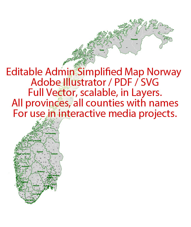
Administrative Vector Map Norway Adobe Illustrator Editable PDF SVG layers simplified Provinces Counties for use in the interactive media projects special edition
Layers: Counties_with_names, Borders_provinces, Names_provinces.
Text format all names
Ready for use in interactive media projects such as http://jvectormap.com/ or jQuery Mapael https://www.vincentbroute.fr/mapael/ https://github.com/neveldo/jQuery-Mapael
Norway.
This vector map of Norway is used as a basis for design, editing, and further printing.
This is the most detailed, exact map of Norway for high-quality printing and polygraphy. You can always clarify the map development date by contacting us.
For your convenience, all objects on Norway vector map are divided into layers. And the editing is very easy – colors, lines, etc.
You can easily add any objects needed (e.g. shops, salons, sale points, gas station or attraction) on any layer of Norway vector map.
Norway is a Nordic country in Northwestern Europe whose core territory comprises the western and northernmost portion of the Scandinavian Peninsula; the remote island of Jan Mayen and the archipelago of Svalbard are also part of the Kingdom of Norway. The Antarctic Peter I Island and the sub-Antarctic Bouvet Island are dependent territories and thus not considered part of the kingdom. Norway also lays claim to a section of Antarctica known as Queen Maud Land.
One of the advantages of Norway vector maps of our production is the relevance of cartographic data, we constantly update all our products.
This vector map of Norway is used by:
designers, layout designers, printers, advertisers and architects. Our product – vector maps – is designed for further editing and printing in large formats – from @Wall format (a few meters) to A-0 and A-1, A-2, A-3.
The Norway map in vector format is used for design, urban planning, presentations and media visualizations.
The advertising and presentation map of Norway (usually the final designer marks the routes, and puts the client’s objects (shops, saloons, gas stations etc.)
The undoubted advantage is that people will NEVER throw out this advertising product – the map. In fact, as an advertising medium, a map is the most “long-playing” of the well-known polygraphic advertising media, with the longest lifespan, and the maximum number of interactions with the customer.
For travelers, maps are sold at the airports and gas stations around the world. Often the source is our vector maps.
Take a look, who purchases our vector maps of Norway in “Our Clients and Friends” page – these are large and small companies, from super-brands like Volvo and Starbucks, to small design studios and printing houses.
It’s very easy to work with vector maps of Norway city, even for a not very experienced designer who can turn on and off the map layers, add new objects, change the colors of fill and lines according to customer requirements.
The undoubted advantage of Norway vector maps in printing is an excellent and detailed visualization, when customer can expand a large paper map and instantly define his location, find a landmark, an object or address on map, unlike using the popular electronic formats of Google and Yandex maps for example.
Printable vector maps of Norway are much more convenient and efficient than any electronic maps on your smartphone, because ALL DETAILS are displayed in the entire space of Norway map.
Useful tips on working with vector maps of cities and countries in Adobe Illustrator.
«V» – launches the Selection tool (cursor, black arrow), which makes active any vector line.
«А» – launches the Direct Selection tool (white cursor), allows you to select curve elements and drag them to the desired place.
«R» – activates the Rotate tool, which helps you rotating selected objects around the center point by 360 degrees.
«E» – gives you the opportunity to use the Eraser tool and erase unnecessary parts.
«X» – switches between Fill and Stroke in the Tools section. Try to get used to this hot key and
you will quickly understand that you can’t live and work without it.
Guides are not limited to vertical and horizontal in Adobe Illustrator. You can also create a diagonal guide for example. Moreover, you can turn any contours into guides. Select the outline and go to View > Guides > Make Guides (Create Guides), or simply press Cmd/Ctrl + 5. You can also turn the guides back into an editable object. Go to menu, View > Guides > Unlock Guides (Release Guides), select the guide you want to edit and select View > Guides > Release Guides (Reset Guides), or just press Cmd/Ctrl + Option / Alt + 5).
You will probably want to change the color scheme used on our Norway vector map.
To quickly and effectively play with colors.
Of course, you can do it manually, all objects in our Norway vector map are divided according to types and layers, and you can easily change the color gamma of vector objects in groups and layers.
But there is more effective way of working with the whole VECTOR MAP of Norway and all layers:
The overview dialog «Edit colors»/«Repaint Graphic Object» (this dialog box name can change depending on the context):
If you have selected a part or a layer of Norway vector map and open the dialog box by clicking the icon in the Control panel, on the Samples palette or the Color Catalog, or if you choose Edit > Edit Colors> Repaint Graphic Object, then the «Repaint Graphic Object» dialog box appears, and you get access to «Assign» and «Edit» tabs.
If a picture or a map fragment is not selected, and you open the dialog box by clicking the icon in the Control panel, on the Samples palette or in the Color Catalog, the «Edit Colors» dialog box appears and you can only access the «Edit» tab.
Regardless of the name at the top of the dialog box, the right-hand side always displays the color group of the current document, as well as two default color groups: Print Color and Grayscale. These color groups can be selected and used any time.
Create and edit color groups of Norway vector map, and also assign colors using the «Edit Colors»/ а «Repaint Graphic Object» dialog box.
A. Creating and editing of a color group on the «Edit» tab
B. Assigning colors on the «Assign» tab
C. Select a group of colors from the «Color groups» list
The option «Repaint a graphic object» in the lower part of the dialog box allows you to preview the colors on a selected layer of Vector map, or a group of elements, and specify whether its colors will be redefined when the dialog box is closed.
The main areas of the dialog box are:
«Edit»
The «Edit» tab is designed to create a new or edit the existing color groups.
The harmony rules Menu and the Color Wheel are used to conduct experiments with color harmonies. The color wheel shows how colors are related in color harmony, and the color bars allow you to view and manipulate an individual color values. In addition, you can adjust the brightness, add and remove colors, save color groups and view colors on the selected Vector Map of Norway or a separated layers.
«Assign»
The «Assign» tab is used to view and control on how the original colors are replaced with colors from the color group like your corporate colors in the Vector Map of Norway city.
The assign color ability is provided only if the entire map, layer or fragment is selected in the document. You can specify which of new colors replace the current colors, whether the spot colors should be preserved and how colors are replaced (for example, you can replace colors completely or changing the color tone while maintaining the brightness). The «Assign» tab allows you to redefine colors in the Vector Map of Norway city, or in separate layers and fragments using the current color group or reducing the number of colors in the current Vector Map.
Color groups
Is a list of all saved color groups for current document (the same groups appear in the «Samples» palette). You can edit and delete the existing color groups, as well as creating a new ones using the list of “Color Groups” in the dialog box. All changes appear in the «Samples» palette.
The highlighted color group shows, which color group is currently edited.
Any color group can be selected and edited, or used to redefine the colors in the selected vector map of Norway city, its fragments or elements.
Saving a color group adds this group to the specified list.
Opening the «Edit Colors»/«Repaint Graphic Object» dialog box.
Open the «Edit Colors»/«Repaint Graphic Object» dialog box using one of the following methods:
«Edit»> «Edit Colors»> «Repaint Graphic object» or «Repaint With Style».
Use these commands if you need to edit the colors in the selected vector map of Norway city.
«Repaint Graphic object» button on the «Control» panel.
Use this button if you need to adjust colors of Norway vector map using the а «Repaint graphic object» dialog box.
The specified button is available if the selected vector map or its fragment contains two or more colors.
Note. This color editing method is convenient for global color adjustment in a vector map, if global colors were not used when creating a Map of Norway.
The «Edit colors» button or «Edit or apply colors» on the «Color Catalog» palette
Click this button if you need to edit colors on the «Color Catalog» palette or edit and then apply them to the selected Vector Map of Norway or its fragment.
The «Edit color group» button or «Edit or apply color group» on the «Samples» palette.
Click this button if you need to edit the colors in the specific color group or edit and apply them to the selected Vector Map of Norway or a group of its elements, for example, the whole layer “Streets and lines”. You can also double-click the color group in the Samples panel to open the dialog box.
If the map file is too large and your computer freezes or even can’t open it quickly:
1. Try to reduce the color resolution of the video card (display) to 256 colors while working with a large map.
2. Using Windows Task Manager, select all the application you don’t need, while working with map, just turn them off.
3. Launch Adobe Illustrator. (DO NOT OPEN the vector map file)
4. Start the Windows Task Manager using administrator rights > Find the “Illustrator” process > set the «real time» priority,
5. Open the file. When you see the LEGACY FONT popup window – click “OK” (do not update). You can restore the TEXT later.
6. Can also be useful: When file is opened – Edit > Settings > Basic Settings > disable smoothing. /// It looks scary, but works quickly)))
We recommend saving the file in Adobe Illustrator 10 version. It’s much more stable when working with VERY BIG size files.
Norway has a total area of 385,252 square kilometres (148,747 sq mi) and a population of 5,312,300 (as of August 2018). The country shares a long eastern border with Sweden (1,619 km or 1,006 mi long). Norway is bordered by Finland and Russia to the north-east, and the Skagerrak strait to the south, with Denmark on the other side. Norway has an extensive coastline, facing the North Atlantic Ocean and the Barents Sea.
King Harald V of the Dano-German House of Glücksburg is the current King of Norway. Erna Solberg became prime minister in 2013 and was reelected in September 2017. Erna Solberg replaced Jens Stoltenberg who was the prime minister between 2000 and 2001 and 2005–2013. A unitary sovereign state with a constitutional monarchy, Norway divides state power between the Parliament, the cabinet and the Supreme Court, as determined by the 1814 Constitution. The kingdom was established as a merger of a large number of petty kingdoms. By the traditional count from 872, the kingdom has existed continuously for 1,145 years, and the list of Norwegian monarchs includes over sixty kings and earls. From 1537 to 1814, Norway was a part of the Kingdom of Denmark-Norway, and from 1814 to 1905, it was in a personal union with the Kingdom of Sweden. Norway was neutral during the first World War. Norway remained neutral until April 1940 when the country was invaded and occupied by Germany until the end of World War II.
Norway has both administrative and political subdivisions on two levels: counties and municipalities. The Sámi people have a certain amount of self-determination and influence over traditional territories through the Sámi Parliament and the Finnmark Act. Norway maintains close ties with both the European Union and the United States. Norway is a founding member of the United Nations, NATO, the European Free Trade Association, the Council of Europe, the Antarctic Treaty, and the Nordic Council; a member of the European Economic Area, the WTO, and the OECD; and a part of the Schengen Area.
Norway maintains the Nordic welfare model with universal health care and a comprehensive social security system, and its values are rooted in egalitarian ideals. The Norwegian state has large ownership positions in key industrial sectors, having extensive reserves of petroleum, natural gas, minerals, lumber, seafood, and fresh water. The petroleum industry accounts for around a quarter of the country’s gross domestic product (GDP). On a per-capita basis, Norway is the world’s largest producer of oil and natural gas outside of the Middle East.
The country has the fourth-highest per capita income in the world on the World Bank and IMF lists. On the CIA’s GDP (PPP) per capita list (2015 estimate) which includes autonomous territories and regions, Norway ranks as number eleven. It has the world’s largest sovereign wealth fund, with a value of USD 1 trillion. Norway has had the highest Human Development Index ranking in the world since 2009, a position also held previously between 2001 and 2006. It also had the highest inequality-adjusted ranking until 2018 when Iceland moved to the top of the list. Norway ranked first on the World Happiness Report for 2017 and currently ranks first on the OECD Better Life Index, the Index of Public Integrity, and the Democracy Index. Norway has one of the lowest crime rates in the world.
Geography
Norway’s core territory comprises the western and northernmost portion of the Scandinavian Peninsula; the remote island of Jan Mayen and the archipelago of Svalbard are also part of the Kingdom of Norway. The Antarctic Peter I Island and the sub-Antarctic Bouvet Island are dependent territories and thus not considered part of the Kingdom. Norway also lays claim to a section of Antarctica known as Queen Maud Land. From the Middle ages to 1814 Norway was part of the Danish kingdom. Norwegian possessions in the North Atlantic, Faroe Islands, Greenland, and Iceland, remained Danish when Norway was passed to Sweden at the Treaty of Kiel. Norway also comprised Bohuslän until 1658, Jämtland and Härjedalen until 1645, Shetland and Orkney until 1468, and the Hebrides and Isle of Man until the Treaty of Perth in 1266.
Norway comprises the western and northernmost part of Scandinavia in Northern Europe. Norway lies between latitudes 57° and 81° N, and longitudes 4° and 32° E. Norway is the northernmost of the Nordic countries and if Svalbard is included also the easternmost. Vardø at 31° 10′ 07″ east of Greenwich lies further east than St. Petersburg and Istanbul. Norway includes the northernmost point on the European mainland. The rugged coastline is broken by huge fjords and thousands of islands. The coastal baseline is 2,532 kilometres (1,573 mi). The coastline of the mainland including fjords stretches 28,953 kilometres (17,991 mi), when islands are included the coastline has been estimated to 100,915 kilometres (62,706 mi). Norway shares a 1,619-kilometre (1,006 mi) land border with Sweden, 727 kilometres (452 mi) with Finland, and 196 kilometres (122 mi) with Russia to the east. To the north, west and south, Norway is bordered by the Barents Sea, the Norwegian Sea, the North Sea, and Skagerrak. The Scandinavian Mountains form much of the border with Sweden.
At 385,252 square kilometres (148,747 sq mi) (including Svalbard and Jan Mayen) (and 323,802 square kilometres (125,021 sq mi) without), much of the country is dominated by mountainous or high terrain, with a great variety of natural features caused by prehistoric glaciers and varied topography. The most noticeable of these are the fjords: deep grooves cut into the land flooded by the sea following the end of the Ice Age. Sognefjorden is the world’s second deepest fjord, and the world’s longest at 204 kilometres (127 mi). Hornindalsvatnet is the deepest lake in all Europe. Norway has about 400,000 lakes. There are registred 239,057 islands. Permafrost can be found all year in the higher mountain areas and in the interior of Finnmark county. Numerous glaciers are found in Norway.
The land is mostly made of hard granite and gneiss rock, but slate, sandstone, and limestone are also common, and the lowest elevations contain marine deposits. Because of the Gulf Stream and prevailing westerlies, Norway experiences higher temperatures and more precipitation than expected at such northern latitudes, especially along the coast. The mainland experiences four distinct seasons, with colder winters and less precipitation inland. The northernmost part has a mostly maritime Subarctic climate, while Svalbard has an Arctic tundra climate.
Because of the large latitudinal range of the country and the varied topography and climate, Norway has a larger number of different habitats than almost any other European country. There are approximately 60,000 species in Norway and adjacent waters (excluding bacteria and virus). The Norwegian Shelf large marine ecosystem is considered highly productive.
Norway
Country in Europe
Norway is a Scandinavian country encompassing mountains, glaciers and deep coastal fjords. Oslo, the capital, is a city of green spaces and museums. Preserved 9th-century Viking ships are displayed at Oslo’s Viking Ship Museum. Bergen, with colorful wooden houses, is the starting point for cruises to the dramatic Sognefjord. Norway is also known for fishing, hiking and skiing, notably at Lillehammer’s Olympic resort.
Capital: Oslo
Population: 5.233 million (2016) World Bank
Capital and largest city: Oslo; 59°56′N 10°41′E / 59.933°N 10.683°E
Official languages: Norwegian, Bokmål, Nynorsk, Saami, North

 Author: Kirill Shrayber, Ph.D. FRGS

 + Relief + Admin Areas editable Adobe Illustrator in layers (2 parts NS)")
 in ONE file + Relief + Admin Areas editable Adobe Illustrator in layers")