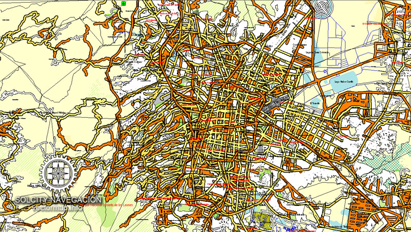
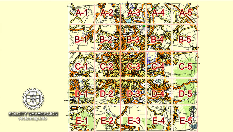
Mexico City with neighborhoods and suburbs 25 parts Full vector map with street names in AI (Illustrator).
Some buildings, full street map with neighborhoods and suburbs
Mexico, North America
Archive size: 49.0 Mb, zipped .AI
DPI: 300
This vector maps of Mexico City is created using 2016 data.
License: Royalty Free
Attention: See montage scheme A-1 ~ E-5
Separated layers, all names in text format.
Good for print in A0 format = 2xA0
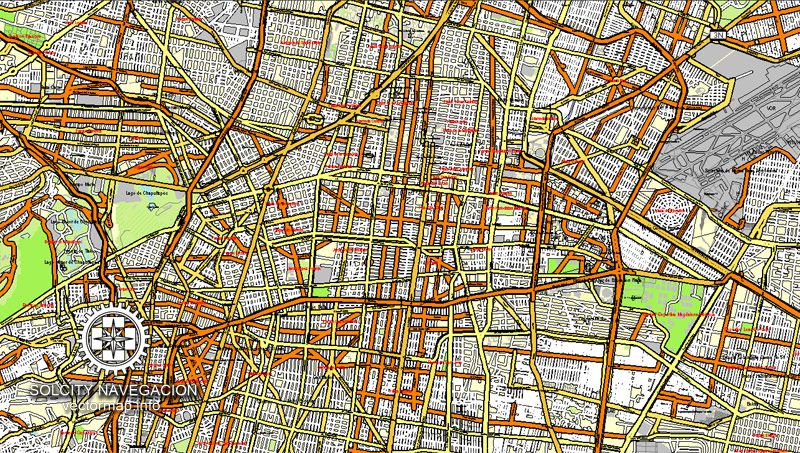
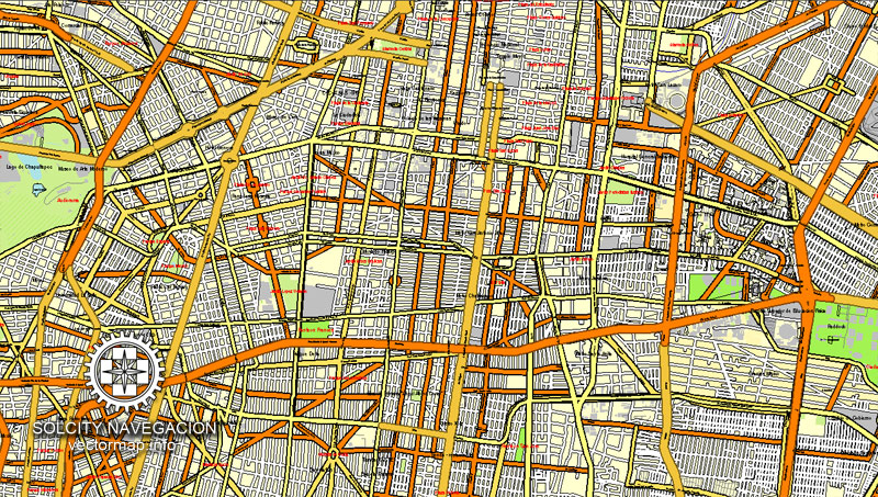
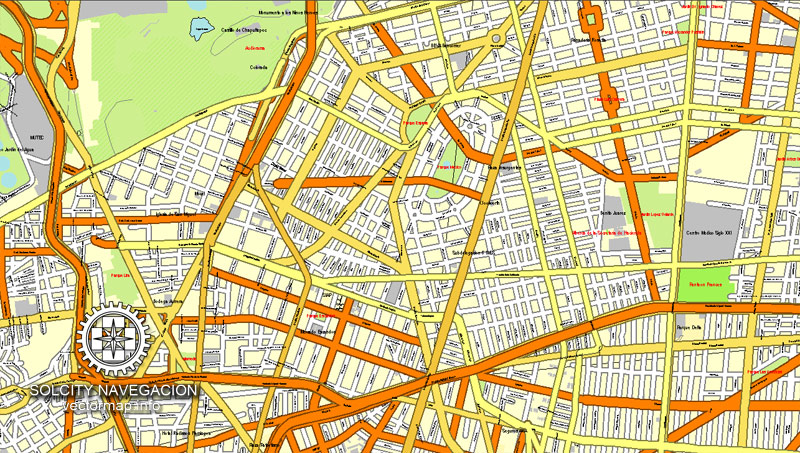
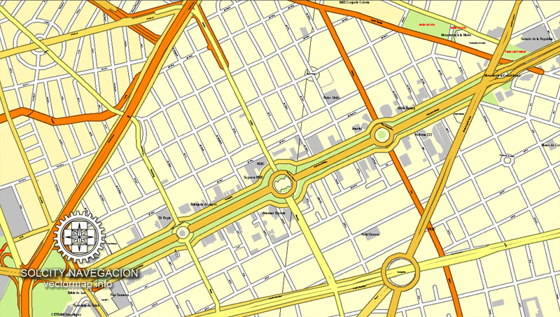
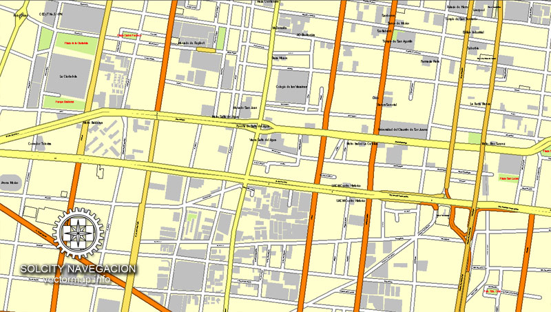
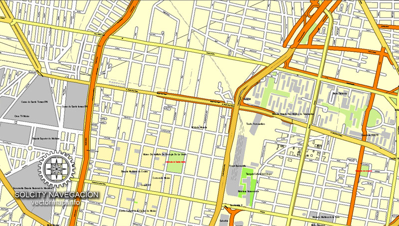
Mexico City (Mexico) vector maps in Adobe Illustrator format (.AI) features (check the preview images):
Highways with names,
Major Roads,
National Park Borders,
Minor Roads,
Big and small Rivers, small streams also,
Lake, ponds and other water bodies,
Landmark fill,
Some buildings,
with neighborhoods and suburbs,
Recreation zones,
Parks.
By request, if needed:
POI (Points of Interest) like: restaurants, hospital, shops, drugstores, military objects or tourist attractive points.
Our maps can be suited to any size needed. Perfect for presentation or large size printing, like office walls (we are sure, Big Boss wants one of this) or bigboards. We provide detailed maps of Mexico City (Mexico) in AI. Being vector maps, they are completely editable, you can add your company logo or change fonts style, line thickness or borders. Need more objects (POI) on map? We can add it with no extra fee. Separated layers, you can turn on or off layer needed.
Please also check other vector maps of Mexico we have.
You can customize all map data using different vector graphics editors like: Adobe Illustrator, Freehand or CorelDraw, Autocad or Freehand. And also is a fully scalable map, no matter what size you need.
This vector map of Mexico City is available in different vector formats (the same price): .AI, .CDR .DWG, .DXF, .EPS, .PDF.
Royalty Free license. You don`t pay extra: per volume sold; for each use; for period of use.
Mexico City map with big “zoom” without quality degradation. The difference between raster and vector is that vector can be adjusted to any size you need with NO quality loss. Perfect for large-size printing (walls & billboards, tourist map. business map).
Probably, you need more objects to be added? Just tell us, we don`t charge for this work.
Mexico City, Mexico.
This vector map of Mexico is used as a basis for design, editing, and further printing.
This is the most detailed, exact map of Mexico for high-quality printing and polygraphy. You can always clarify the map development date by contacting us.
For your convenience, all objects on Mexico vector map are divided into layers. And the editing is very easy – colors, lines, etc.
You can easily add any objects needed (e.g. shops, salons, sale points, gas station or attraction) on any layer of Mexico vector map.
Mexico City is the capital of Mexico and the most populous city in North America. Mexico City is one of the most important cultural and financial centres in the Americas. It is located in the Valley of Mexico (Valle de México), a large valley in the high plateaus in the center of Mexico, at an altitude of 2,240 meters (7,350 ft). The city has 16 boroughs.
One of the advantages of Mexico vector maps of our production is the relevance of cartographic data, we constantly update all our products.
This vector map of Mexico is used by:
designers, layout designers, printers, advertisers and architects. Our product – vector maps – is designed for further editing and printing in large formats – from @Wall format (a few meters) to A-0 and A-1, A-2, A-3.
Mexico map in vector format is used for design, urban planning, presentations and media visualizations.
Advertising and presentation map of Mexico (usually the final designer marks the routes, and puts the client’s objects (shops, saloons, gas stations etc.)
The undoubted advantage is that people will NEVER throw out this advertising product – the map. In fact, as an advertising medium, a map is the most “long-playing” of the well-known polygraphic advertising media, with the longest lifespan, and the maximum number of interactions with the customer.
For travelers, maps are sold at the airports and gas stations around the world. Often the source is our vector maps.
Take a look, who purchases our vector maps of Mexico in “Our Clients and Friends” page – these are large and small companies, from super-brands like Volvo and Starbucks, to small design studios and printing houses.
It’s very easy to work with vector maps of Mexico, even for a not very experienced designer who can turn on and off the map layers, add new objects, change the colors of fill and lines according to customer requirements.
The undoubted advantage of Mexico vector maps in printing is an excellent and detailed visualization, when customer can expand a large paper map and instantly define his location, find a landmark, an object or address on map, unlike using the popular electronic formats of Google and Yandex maps for example.
Printable vector maps of Mexico are much more convenient and efficient than any electronic maps on your smartphone, because ALL DETAILS are displayed in the entire space of Mexico map.
Useful tips on working with vector maps of cities and countries in Adobe Illustrator.
«V» – launches the Selection tool (cursor, black arrow), which makes active any vector line.
«А» – launches the Direct Selection tool (white cursor), allows you to select curve elements and drag them to the desired place.
«R» – activates the Rotate tool, which helps you rotating selected objects around the center point by 360 degrees.
«E» – gives you the opportunity to use the Eraser tool and erase unnecessary parts.
«X» – switches between Fill and Stroke in the Tools section. Try to get used to this hot key and
you will quickly understand that you can’t live and work without it.
Guides are not limited to vertical and horizontal in Adobe Illustrator. You can also create a diagonal guide for example. Moreover, you can turn any contours into guides. Select the outline and go to View > Guides > Make Guides (Create Guides), or simply press Cmd/Ctrl + 5. You can also turn the guides back into an editable object. Go to menu, View > Guides > Unlock Guides (Release Guides), select the guide you want to edit and select View > Guides > Release Guides (Reset Guides), or just press Cmd/Ctrl + Option / Alt + 5).
You will probably want to change the color scheme used on our Mexico vector map.
To quickly and effectively play with colors.
Of course, you can do it manually, all objects in our Mexico vector map are divided according to types and layers, and you can easily change the color gamma of vector objects in groups and layers.
But there is more effective way of working with the whole VECTOR MAP of Mexico and all layers:
The overview dialog «Edit colors»/«Repaint Graphic Object» (this dialog box name can change depending on the context):
If you have selected a part or a layer of Mexico vector map and open the dialog box by clicking the icon in the Control panel, on the Samples palette or the Color Catalog, or if you choose Edit > Edit Colors> Repaint Graphic Object, then the «Repaint Graphic Object» dialog box appears, and you get access to «Assign» and «Edit» tabs.
If a picture or a map fragment is not selected, and you open the dialog box by clicking the icon in the Control panel, on the Samples palette or in the Color Catalog, the «Edit Colors» dialog box appears and you can only access the «Edit» tab.
Regardless of the name at the top of the dialog box, the right-hand side always displays the color group of the current document, as well as two default color groups: Print Color and Grayscale. These color groups can be selected and used any time.
Create and edit color groups of Mexico vector map, and also assign colors using the «Edit Colors»/ а «Repaint Graphic Object» dialog box.
A. Creating and editing of a color group on the «Edit» tab
B. Assigning colors on the «Assign» tab
C. Select a group of colors from the «Color groups» list
The option «Repaint a graphic object» in the lower part of the dialog box allows you to preview the colors on a selected layer of Vector map, or a group of elements, and specify whether its colors will be redefined when the dialog box is closed.
The main areas of the dialog box are:
«Edit»
The «Edit» tab is designed to create a new or edit the existing color groups.
The harmony rules Menu and the Color Wheel are used to conduct experiments with color harmonies. The color wheel shows how colors are related in color harmony, and the color bars allow you to view and manipulate an individual color values. In addition, you can adjust the brightness, add and remove colors, save color groups and view colors on the selected Vector Map of Mexico or a separated layers.
«Assign»
The «Assign» tab is used to view and control on how the original colors are replaced with colors from the color group like your corporate colors in the Vector Map of Mexico.
The assign color ability is provided only if the entire map, layer or fragment is selected in the document. You can specify which of new colors replace the current colors, whether the spot colors should be preserved and how colors are replaced (for example, you can replace colors completely or changing the color tone while maintaining the brightness). The «Assign» tab allows you to redefine colors in the Vector Map of Mexico, or in separate layers and fragments using the current color group or reducing the number of colors in the current Vector Map.
Color groups
Is a list of all saved color groups for current document (the same groups appear in the «Samples» palette). You can edit and delete the existing color groups, as well as creating a new ones using the list of “Color Groups” in the dialog box. All changes appear in the «Samples» palette.
The highlighted color group shows, which color group is currently edited.
The 2009 population for the city proper was approximately 8.84 million people, with a land area of 1,485 square kilometers (573 sq mi). According to the most recent definition agreed upon by the federal and state governments, the population of Greater Mexico City is 21.3 million, which makes it the largest metropolitan area of the Western Hemisphere, the eleventh-largest agglomeration (2017), and the largest Spanish-speaking city in the world.
Any color group can be selected and edited, or used to redefine the colors in the selected vector map of Mexico, its fragments or elements.
Saving a color group adds this group to the specified list.
Opening the «Edit Colors»/«Repaint Graphic Object» dialog box.
Open the «Edit Colors»/«Repaint Graphic Object» dialog box using one of the following methods:
«Edit»> «Edit Colors»> «Repaint Graphic object» or «Repaint With Style».
Use these commands if you need to edit the colors in the selected vector map of Mexico.
«Repaint Graphic object» button on the «Control» panel.
Use this button if you need to adjust colors of Mexico vector map using the а «Repaint graphic object» dialog box.
The specified button is available if the selected vector map or its fragment contains two or more colors.
Note. This color editing method is convenient for global color adjustment in a vector map, if global colors were not used when creating a Map of Mexico.
The «Edit colors» button or «Edit or apply colors» on the «Color Catalog» palette
Click this button if you need to edit colors on the «Color Catalog» palette or edit and then apply them to the selected Vector Map of Mexico or its fragment.
The «Edit color group» button or «Edit or apply color group» on the «Samples» palette.
Click this button if you need to edit the colors in the specific color group or edit and apply them to the selected Vector Map of Mexico or a group of its elements, for example, the whole layer “Streets and lines”. You can also double-click the color group in the Samples panel to open the dialog box.
If the map file is too large and your computer freezes or even can’t open it quickly:
1. Try to reduce the color resolution of the video card (display) to 256 colors while working with a large map.
2. Using Windows Task Manager, select all the application you don’t need, while working with map, just turn them off.
3. Launch Adobe Illustrator. (DO NOT OPEN the vector map file)
4. Start the Windows Task Manager using administrator rights > Find the “Illustrator” process > set the «real time» priority,
5. Open the file. When you see the LEGACY FONT popup window – click “OK” (do not update). You can restore the TEXT later.
6. Can also be useful: When file is opened – Edit > Settings > Basic Settings > disable smoothing. /// It looks scary, but works quickly)))
We recommend saving the file in Adobe Illustrator 10 version. It’s much more stable when working with VERY BIG size files.
Greater Mexico City has a GDP of $411 billion in 2011, making Greater Mexico City one of the most productive urban areas in the world. The city was responsible for generating 15.8% of Mexico’s GDP, and the metropolitan area accounted for about 22% of total national GDP. If it were an independent country, in 2013, Mexico City would be the fifth-largest economy in Latin America, five times as large as Costa Rica and about the same size as Peru.
Mexico’s capital is both the oldest capital city in the Americas and one of two founded by Native Americans, the other being Quito, Ecuador. The city was originally built on an island of Lake Texcoco by the Aztecs in 1325 as Tenochtitlan, which was almost completely destroyed in the 1521 siege of Tenochtitlan and subsequently redesigned and rebuilt in accordance with the Spanish urban standards. In 1524, the municipality of Mexico City was established, known as México Tenochtitlán, and as of 1585, it was officially known as Ciudad de México (Mexico City). Mexico City was the political, administrative, and financial center of a major part of the Spanish colonial empire. After independence from Spain was achieved, the federal district was created in 1824.
After years of demanding greater political autonomy, residents were finally given the right to elect both a Head of Government and the representatives of the unicameral Legislative Assembly by election in 1997. Ever since, the left-wing Party of the Democratic Revolution (PRD) has controlled both of them. The city has several progressive policies, such as abortion on request, a limited form of euthanasia, no-fault divorce, and same-sex marriage.
On January 29, 2016, it ceased to be the Federal District (Spanish: Distrito Federal or D.F.), and is now officially known as “Ciudad de México” (or “CDMX”), with a greater degree of autonomy. A clause in the Constitution of Mexico, however, prevents it from becoming a state, as it is the seat of power in the country, unless the capital of the country were relocated elsewhere.
Mexico City is located in the Valley of Mexico, sometimes called the Basin of Mexico. This valley is located in the Trans-Mexican Volcanic Belt in the high plateaus of south-central Mexico. It has a minimum altitude of 2,200 meters (7,200 feet) above sea level and is surrounded by mountains and volcanoes that reach elevations of over 5,000 meters (16,000 feet). This valley has no natural drainage outlet for the waters that flow from the mountainsides, making the city vulnerable to flooding. Drainage was engineered through the use of canals and tunnels starting in the 17th century.
Mexico City primarily rests on what was Lake Texcoco. Seismic activity is frequent there. Lake Texcoco was drained starting from the 17th century. Although none of the lake waters remain, the city rests on the lake bed’s heavily saturated clay. This soft base is collapsing due to the over-extraction of groundwater, called groundwater-related subsidence. Since the beginning of the 20th century the city has sunk as much as nine meters (30 feet) in some areas. This sinking is causing problems with runoff and wastewater management, leading to flooding problems, especially during the rainy season. The entire lake bed is now paved over and most of the city’s remaining forested areas lie in the southern boroughs of Milpa Alta, Tlalpan and Xochimilco.
Mexico City map with neighborhoods and suburbs (Mexico, North America) in vector.
Our vector map of Mexico City includes maps of the nearest areas (see the preview):
Mexico City vector map for Adobe Illustrator. Purchasing and downloading.
Credit Card and PayPal payment accepted. After the payment you will be redirected to the download page.
We also offer custom mapping. If you need something special – just contact our friendly team.
Es: Ciudad de México con los barrios y suburbios 25 partes completo mapa vectorial con nombres de calles en AI (Illustrator).
Algunos edificios, callejero completo con los barrios y suburbios
México, América del Norte
Tamaño del archivo: 49,0 Mb, con cremallera .AI
DPI: 300
Este vector mapas de la ciudad de México usa la información de 2016.
Licencia: Libre de derechos
Capas separadas, todos los nombres en formato texto.
Bueno para impresión en formato A0 = 2xA0
Ciudad de México (México) mapas vectoriales en formato Adobe Illustrator (.AI) cuenta (marcar las imágenes de vista previa):
Carreteras con nombres,
Principales carreteras,
Parque Nacional de Fronteras,
Carreteras secundarias,
Los ríos grandes y pequeños, pequeños arroyos también,
Lago, lagunas y otros cuerpos de agua,
Relleno Landmark,
Algunos edificios,
con los barrios y suburbios,
Zonas de recreo,
Parques.
Por petición, si es necesario:
POI (puntos de interés) como: restaurantes, hospitales, tiendas, farmacias, objetos militares o puntos turísticos atractivos.
Nuestros mapas pueden ser adaptados a cualquier tamaño necesario. Perfecto para la presentación o la impresión de gran tamaño, como paredes de la oficina (estamos seguros, Big Boss quiere uno de ello) o billboards. Proporcionamos mapas detallados de la Ciudad de México (México) en la IA. Siendo mapas vectoriales, que son totalmente editable, puede añadir el logotipo de su empresa o cambiar las fuentes de estilo, grosor de línea o fronteras. ¿Necesitas más objetos (POI) en el mapa? Podemos añadir que sin ningún cargo extra. Capas separadas, se puede activar o desactivar la capa sea necesario.
Por favor, compruebe también otros mapas vectoriales de México que tenemos.
Usted puede personalizar todos los datos de los mapas utilizando diferentes editores de gráficos vectoriales como Adobe Illustrator, Freehand o CorelDraw, AutoCAD o Freehand. Y también es un mapa totalmente escalable, sin importar el tamaño que usted necesita.
Este mapa vectorial de la Ciudad de México está disponible en diferentes formatos vectoriales (el mismo precio): .AI, .CDR .DWG, .DXF, .EPS, .PDF.
Imagen de archivo libre de licencia. Usted don `t pagar extra: por volumen vendido; para cada uso; para el período de uso.
Mapa de la Ciudad de México con el “zoom” grande sin degradación de la calidad. La diferencia entre raster y vector es que el vector se puede ajustar a cualquier tamaño que usted necesita sin pérdida de calidad. Perfecto para impresión de gran tamaño (paredes y vallas publicitarias, mapa turístico. Mapa empresarial).
Probablemente, usted necesita más objetos que se añadirán? Sólo tienes que decirnos, ponemos el `t responsable de este trabajo.
Ciudad de México Mapa con los barrios y suburbios (México, América del Norte) en el vector.
Nuestro mapa vectorial de la Ciudad de México incluye mapas de las áreas más cercanas (ver la vista previa):
Ciudad de México mapa vectorial para Adobe Illustrator. Compras y descarga.
Tarjeta de crédito y pago de PayPal aceptaron. Después del pago usted será redirigido a la página de descarga.
También ofrecemos asignación personalizada. Si necesita algo especial – sólo en contacto con nuestro equipo.
Small guide: How to work with the vector map?
You can: Mass select objects by type and color – for example, the objects type “building” (they are usually dark gray) – and remove them from the map, if you do not need them in your print or design project. You can also easily change the thickness of lines (streets), just bulk selection the road by the line color.
The streets are separated by type, for example, type “residential road” are usually white with a gray stroke. Highway usually orange with a brown or dark gray stroke.
All objects are divided by types: different types of roads and streets, polygons of buildings, landfills, urban areas, parks and more other.
It is easy to change the font of inscriptions, all or each individually. Also, just can be make and any other manipulation of objects on the vector map in Adobe illustrator format.
Important: All the proportions on the map are true, that is, the relative sizes of the objects are true, because Map is based on an accurate GPS projection, and It transated into the (usual for all) the Mercator projection.
You can easily change the color, stroke and fill of any object on the map, zoom without loss of quality Image Verification.
Select object

Bulk selection the same objects on the vector map

See the bulk selected objects on the vector map

Bulk delete buildungs from the vector map

Select residencial road (small street) on the vector map

Bulk selection the same lines (streets, roads) on the full map

Create fat lines of the streets on the vector maps (bulk action) 1

Create fat lines of the streets on the vector maps (bulk action) 2

Create fat lines of the streets on the vector maps (bulk action) 3

You can easily change the color, stroke and fill of any object on the map, zoom without loss of quality Image Verification.

 Author: Kirill Shrayber, Ph.D. FRGS


