Extended Description of the Vector Map
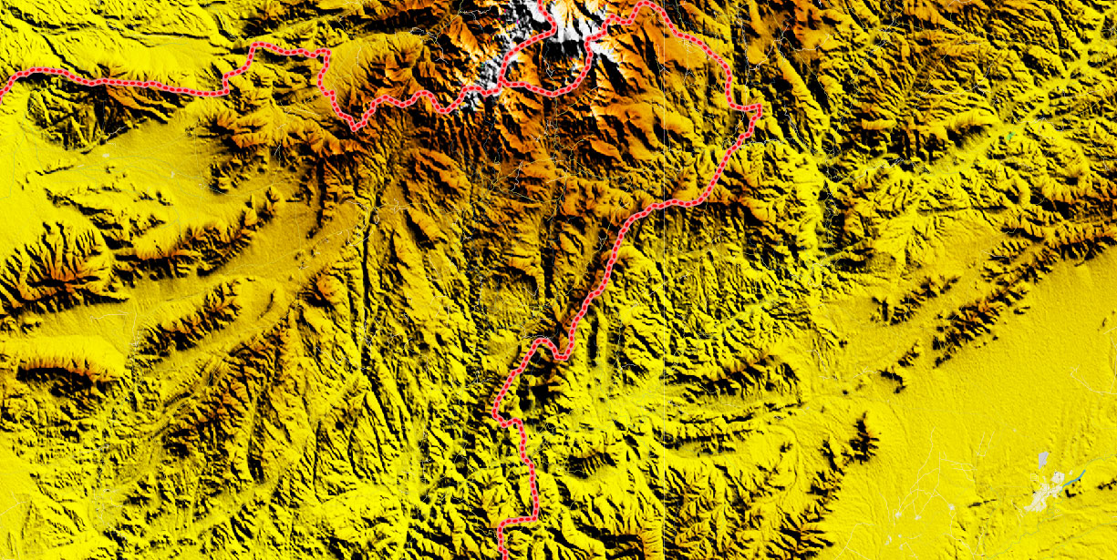
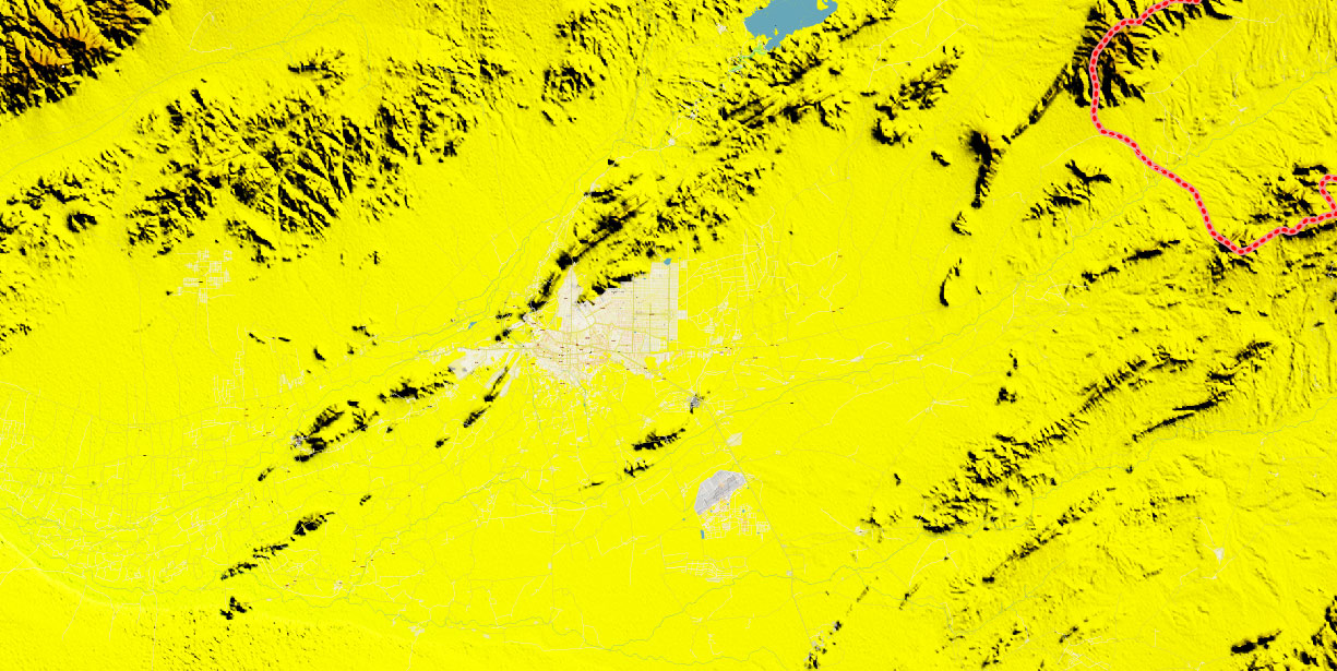
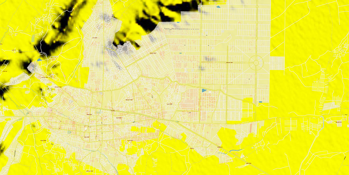
Printable PDF Vector Map of Kandahar Province Afghanistan detailed Relief Road Plan scale full editable Adobe PDF Street Map + Relief Topo Colored Raster in layers, scalable, text/curves format all names, 697 MB ZIP
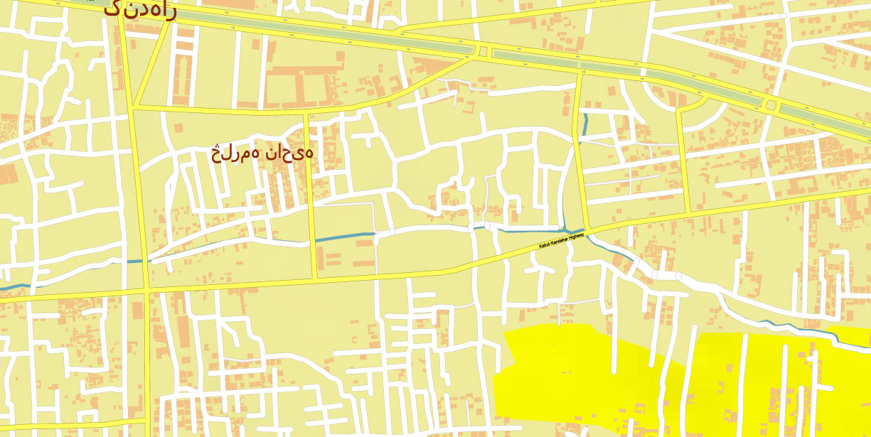
Some street names (ENG), Main Objects, some Buildings, Topo Relief (Colored Raster). Map for design, printing, arts, projects, presentations, for architects, designers, and builders, business, logistics.
Also: We can add (additional layer for this map), any other objects for you. It’s free for our customers.
If you need any OTHER format – DWG, DXF, Corel, or something else – please, email us
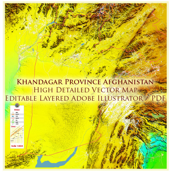
Kandahar Province Afghanistan PDF Vector Map Exact High Detailed editable Adobe PDF Street Map + Relief Topo Raster in layers
Layers list:
- Legend
- Grids
- Labels of roads
- Names of places (city, hamlet, etc.)
- Names of objects (hospitals, parks, water)
- Names of main streets
- Names of residential streets
- Arrows of the street directions
- Main Streets, roads
- Residential streets
- Buildings
- Waterways
- Water objects (rivers, lakes, ponds)
- Airports and Heliports
- Color fills (parks, hospital areas, land use, etc.)
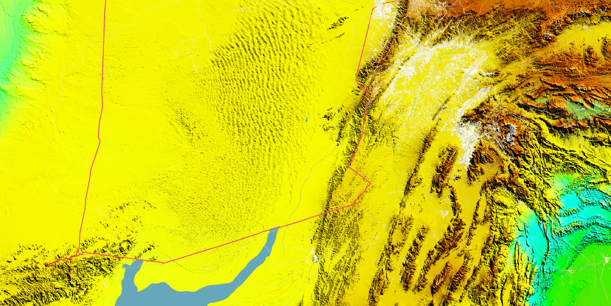
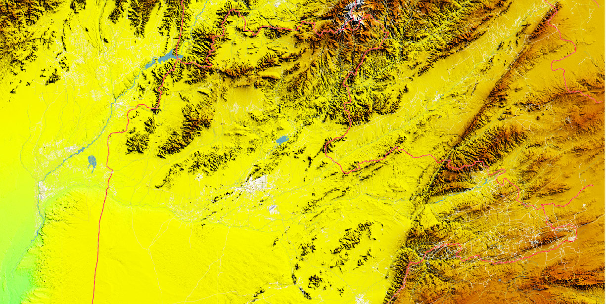
- Relief Topo (Colored Raster)
- Background
Kandahar Province, Afghanistan
Overview
-
Location: South Afghanistan; borders Helmand (W), Uruzgan/Zabul (N/NE), Pakistan–Balochistan (SE via Spin Boldak), Daykundi (NW).
-
Terrain: Mix of Registan Desert (south/southwest), stony plains and low hills (west/north), and the Arghandab/Tarnak river valleys forming a cultivated green belt around Kandahar City. Elev. ~900–1,500 m; broken ridges (Maiwand, Panjwayi, Shah Wali Kot) create micro-valleys and canalized movement.
-
Key nodes: Kandahar City (provincial capital), Kandahar International Airport (KDH), Spin Boldak/Chaman border crossing (“Friendship Gate”).
Key Roads / Lines of Communication
-
A01 (Ring Road / AH1): East–west MSR skirting N of Kandahar City; links Herat–Helmand (W) ↔ Kabul/Ghazni (E). Primary strategic freight artery.
-
Kandahar–Spin Boldak Road (to Chaman/Quetta): SE corridor to Pakistan; heavy commerce, customs, smuggling risk, choke points in towns and wadis.
-
Kandahar–Uruzgan/Zabul spurs: Secondary MSRs through Shah Wali Kot and toward Qalat; narrow passes, ambush terrain.
-
Intra-valley routes: Dense irrigation-canal road net in Panjwayi, Zhari, Arghandab; short sightlines, frequent defiles and low bridges.
-
Condition: Paved on A01/Spin Boldak axis; variable elsewhere (broken asphalt, gravel). Culvert/bridge IED history along canals and wadis.
Urban / Settlements
-
Kandahar City: Administrative/commercial hub; low-rise compounds, bazaars, walled neighborhoods; ring canals/roads.
-
Spin Boldak: Border town, customs yards, rail/road trans-load potential; crowd/congestion hazards.
-
Other districts: Panjwayi, Zhari, Arghandab, Daman, Maiwand, Shah Wali Kot, Khakrez, Reg/Shorabak. Villages are compound clusters (qalats) along canals and wadis.
Water / Irrigation
-
Arghandab River (W→E across N of Kandahar City); Dahla (Arghandab) Dam upstream—controls irrigation flows; canals create lush orchards (pomegranates/grapes).
-
Tarnak & Dori Rivers (intermittent/seasonal) to the east/southeast.
-
Aquifers & karez (traditional underground channels) still present but degraded.
-
Hazards: Seasonal flash flooding in wadis; canal banks = mobility obstacles and IED cover.
Climate / Seasonality
-
Arid steppe–desert.
-
Summer: Very hot (often >40 °C), dust storms, reduced midday mobility; brownout risk for rotary-wing.
-
Winter: Mild/cool days, cold nights; occasional freeze; precipitation low but rain-on-parched events drive flash floods.
-
Fighting season: Typically spring → late autumn (after winter lull).
-
Best mobility: Late autumn–early spring; desert hard-pack improves cross-country, but wadis remain traps after rains.
Demography / Human Terrain
-
Population: ~1–1.5 million (dispersed in river valleys; sparse desert).
-
Ethnic/Tribal: Predominantly Pashtun (Durrani confederation: Popalzai, Barakzai, Alokozai; plus Noorzai, Achakzai); tribal influence strong in rural districts.
-
Economy: Agriculture (orchards, vineyards), cross-border trade at Spin Boldak, informal markets; historical opium cultivation in peripheral districts.
-
Language/Religion: Pashto dominant; Sunni Islam.
Hazards / Threats
-
IED belts on canal roads/culverts; pressure-plate legacy hazards in Panjwayi/Zhari/Maiwand.
-
Complex terrain (walls, orchards, narrow alleys) favors close-range engagements; limited LOS for sensors.
-
Smuggling/cross-border flows via Spin Boldak; sudden crowd surges at the gate.
-
Environmental: Heat injury, dehydration, Haboob dust events, flash floods; UXO in old fighting areas.
Logistics / Sustainment
-
Air: Kandahar International Airport (KDH) — longest, most reliable runway in the south; primary airhead for cargo/MEDEVAC.
-
Ground MSRs: A01 for strategic resupply; Spin Boldak–Quetta route for imports; convoy planning must account for canal bridges, weight limits, and detours.
-
Fuel/water: Commercial fuel available along A01/city; bulk water by treatment or well-points (test for salinity/contamination).
Tourism / Key Compounds (awareness)
Command Takeaways
-
Decisive terrain: Arghandab–Panjwayi–Zhari canal belt and A01/Spin Boldak MSRs. Control of canal crossings and culverts = control of movement.
-
Mobility: Favor valley roads; deserts allow flanking when surface is firm, but navigation/soft sand risks rise south of the city.
-
ISR/FP: Expect short LOS in orchards; use elevated ISR and route-clearance for canalized segments.
-
Sustainment: Leverage KDH airhead; ground convoys time-deconflict with market hours and border surges.
-
Weather: Plan heat mitigation and dust procedures May–Sep; flood contingencies in late winter/spring.
Kandahar Province Afghanistan PDF Vector Map Exact High Detailed editable Adobe PDF Street Map + Relief Topo Raster in layers
Kandahar Province Afghanistan PDF Vector Map Exact High Detailed editable Adobe PDF Street Map + Relief Topo Raster in layers
Kandahar Province Afghanistan PDF Vector Map Exact High Detailed editable Adobe PDF Street Map + Relief Topo Raster in layers
Kandahar Province Afghanistan PDF Vector Map Exact High Detailed editable Adobe PDF Street Map + Relief Topo Raster in layers
Kandahar Province Afghanistan PDF Vector Map Exact High Detailed editable Adobe PDF Street Map + Relief Topo Raster in layers
Kandahar Province Afghanistan PDF Vector Map Exact High Detailed editable Adobe PDF Street Map + Relief Topo Raster in layers

 Author: Kirill Shrayber, Ph.D. FRGS