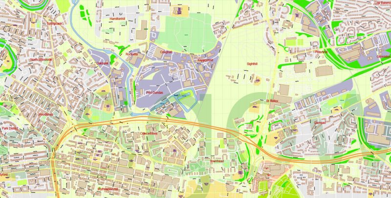
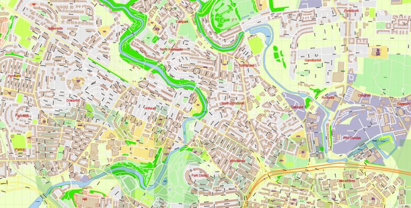
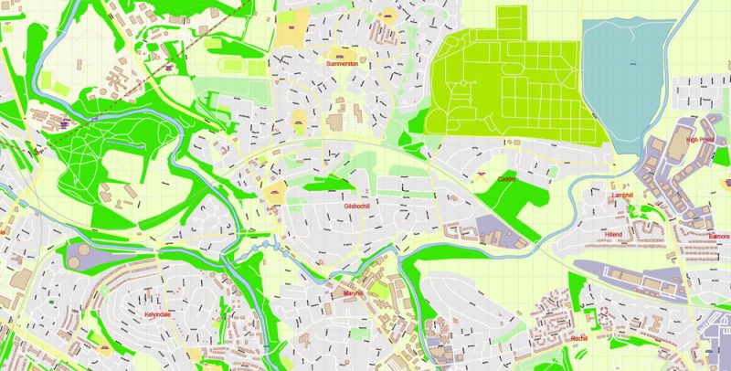
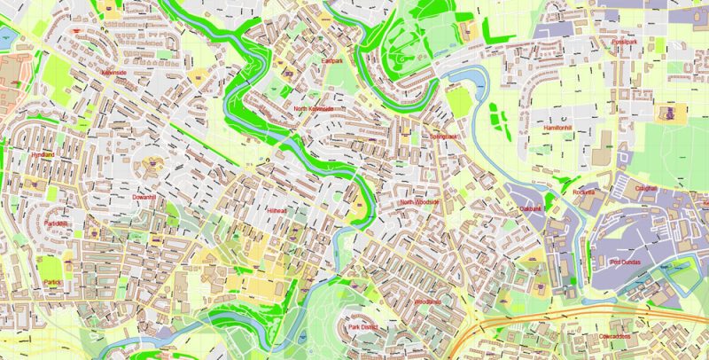
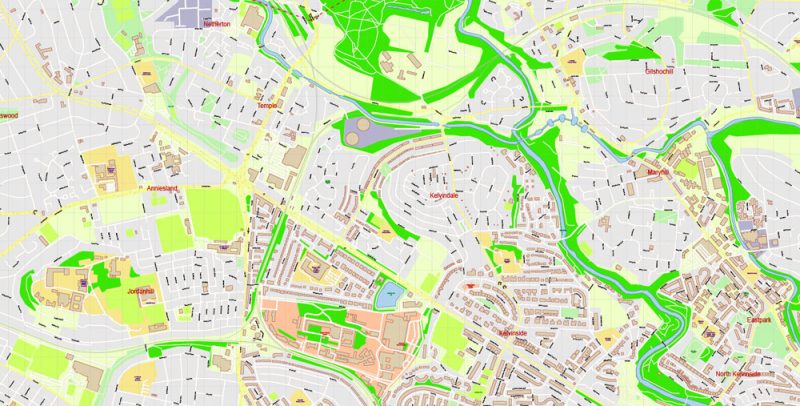
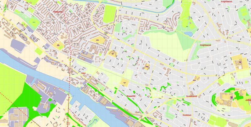
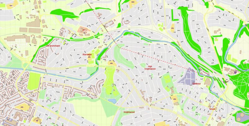
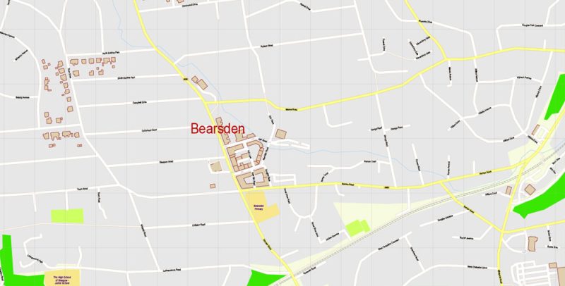
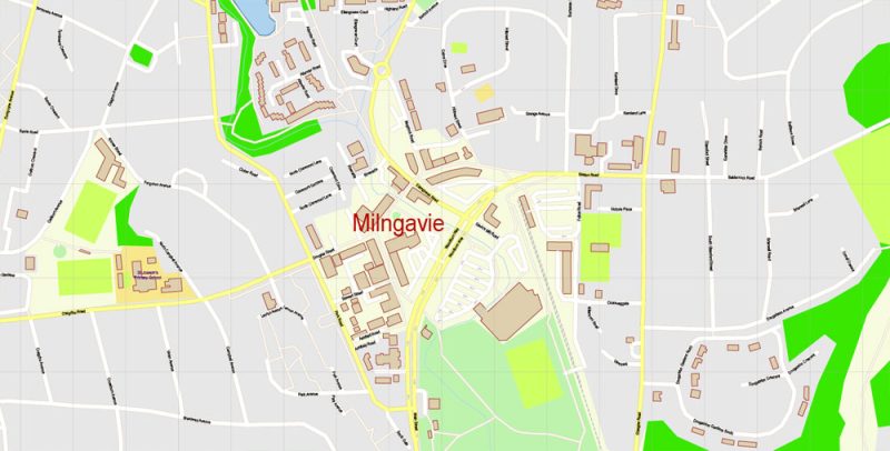
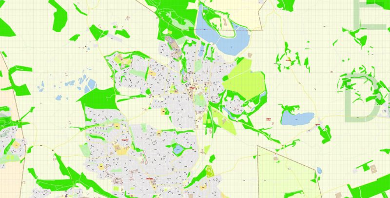
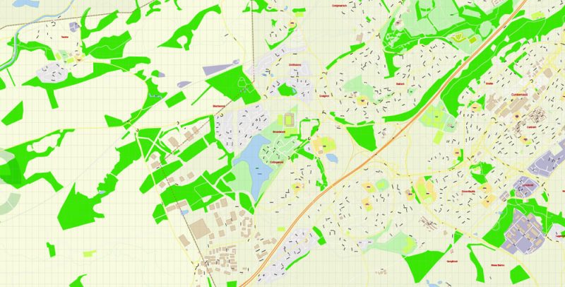
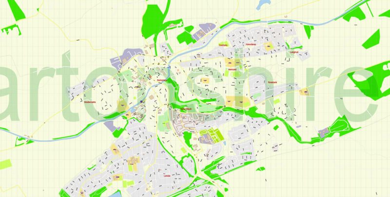
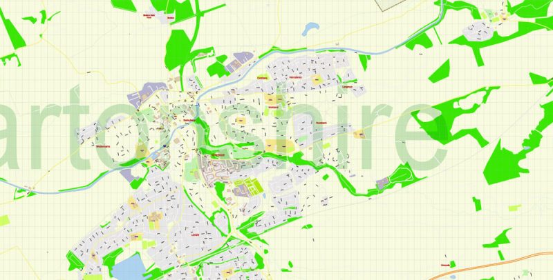
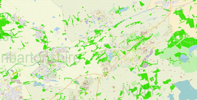
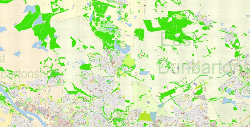
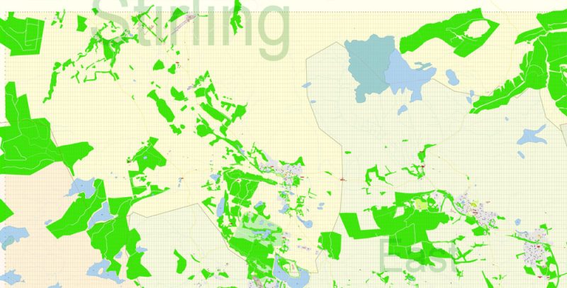
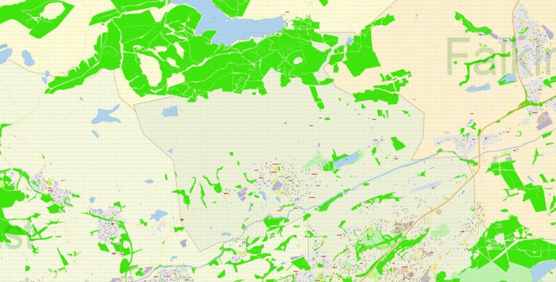
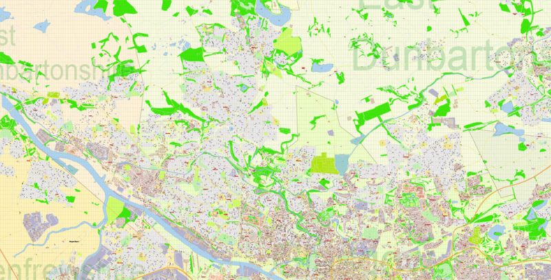
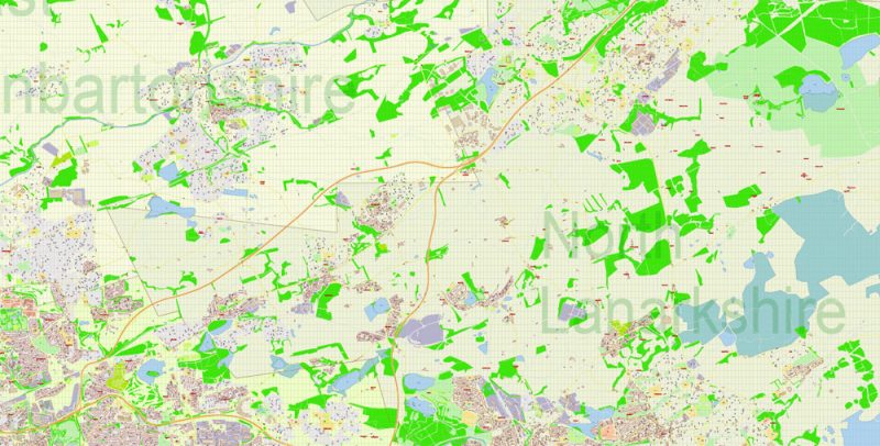
Printable PDF Vector Map of East Dunbartonshire Scotland UK detailed City Plan scale 100 m 1:2630 full editable Adobe PDF Street Map in layers, scalable, text format all names, 46 MB ZIP
All street names, Main Objects, Buildings. Map for design, printing, arts, projects, presentations, for architects, designers, and builders, business, logistics.
Included: The North Part of Glasgow
Layers: color_fills, water, admin_areas, names_admin_areas, streets_roads, labels_roads, names_objects, names_streets, names_places, arrows_streets, buildings, legend, etc.
The most exact and detailed map in scale.
For Editing and High-Quality Printing
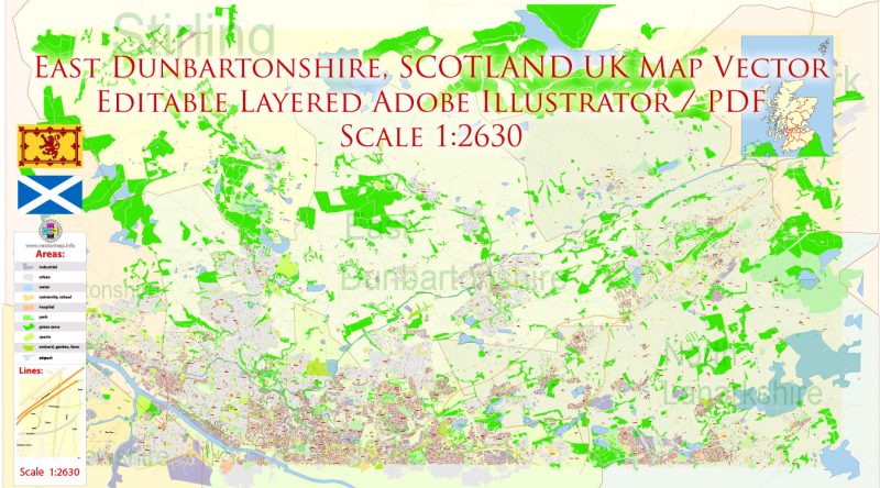
East Dunbartonshire Scotland UK PDF Map Vector Exact State Plan High Detailed Street Road Admin Map editable Adobe PDF in layers
Scotland
Scotland is an integral part of the United Kingdom of Great Britain and Northern Ireland. However, the political status of Scotland in this title is not marked. Although Scotland has never been an Autonomous or Federal unit of Great Britain and is no longer a Kingdom, it is not just a geographical or administrative area. Scotland can be considered as a separate country. Scots defend their national identity and preserve many institutions that do not exist in England and other English-speaking countries. They have their capital Edinburgh, their Church, laws and courts, their banks and banknotes. In Scotland, cities are called burgs (unlike the boroughs in England), and their mayors – Provost (in England – mayors), sheriffs there – judges who receive wages, not honorary dignitaries, as in England.
East Dunbartonshire Scotland UK PDF Map Vector Exact State Plan High Detailed Street Road Admin Map editable Adobe PDF in layers
Footprint (78 772 sq km) Scotland is more than half the size of England and Wales taken together (151 126 thousand sq km), its population in 1991 numbered only 4989 thousand against 49 890 thousand in England and Wales. In the 20th century in Scotland, there were significant changes in the placement of the population: increased migration to the city, where now live 9 out of every 10 Scots. In the mountains and Islands, the population density does not exceed 12 people per 1 square km. However, at present, the population growth centers are not large cities, but their suburban areas.
East Dunbartonshire Scotland UK PDF Map Vector Exact State Plan High Detailed Street Road Admin Map editable Adobe PDF in layers
Scottish parliament
The unicameral legislature of Scotland. The emergence of the Scottish Kingdom Parliament dates back to the XIII century. In 1707, after the unification of England and Scotland into a single Kingdom of Great Britain, the Parliament ceased to exist and was restored only in 1999 under the Scottish act of 1998.
East Dunbartonshire Scotland UK PDF Map Vector Exact State Plan High Detailed Street Road Admin Map editable Adobe PDF in layers
Religion
Many Scots are Presbyterians, and their religious life takes place within the Scottish Church. The adherents of this Church make up 2/3 of all believers, it has a strong influence almost everywhere. The heresies and schisms that afflicted the Scottish Presbyterians in the 18th and 19th centuries are largely overcome. The two extant Presbyterian minority Free Church and Free Presbyterian Church has its supporters mainly in some mountain areas and the Western Isles, where they are very conservative doctrine retains its attractiveness for the population.
East Dunbartonshire Scotland UK PDF Map Vector Exact State Plan High Detailed Street Road Admin Map editable Adobe PDF in layers
Sport
The national sport in Scotland – football, but it is played mainly by professionals. Scotland is the birthplace of Golf, and the sandy East coast offers convenient Golf courses. In the mountains to the children’s play hockey similar to a regular. The costumes of the mountaineers give color to sports competitions, which together with the competitions of players on bagpipes are regularly held in mountainous areas.
East Dunbartonshire Scotland UK PDF Map Vector Exact State Plan High Detailed Street Road Admin Map editable Adobe PDF in layers
The best time to travel is from May to September, but in summer it will not be possible to avoid rain in Edinburgh. In winter, the city is also very beautiful but darkens quite early. In August, during the festival, there are a lot of people in the city who want to visit Edinburgh at this time, you need to worry about booking a hotel in advance.
East Dunbartonshire Scotland UK PDF Map Vector Exact State Plan High Detailed Street Road Admin Map editable Adobe PDF in layers
Transport
The Scottish railway passes only through the main cities of the region — where there are no rails, you will have to use local buses (for example, to get to highland). As in Wales, many remote towns and villages can be reached by Royal Mail Postbuses (usually no more than 4 seats). “The carrier pigeon” is usually followed by alternative routes that (a bonus for the long journey!) often run through the most beautiful corners of Scotland. The official stops these bus there, so they usually just catch on the road.
East Dunbartonshire Scotland UK PDF Map Vector Exact State Plan High Detailed Street Road Admin Map editable Adobe PDF in layers
Scottish cuisine and restaurants
Scotland is famous primarily for beef and lamb dishes, as well as excellent fresh fish (especially good salmon), shellfish and crustaceans. Game dishes (partridge, pheasant) — very lean and healthy, they are often prepared with Scottish raspberries, black currants or blueberries.
East Dunbartonshire Scotland UK PDF Map Vector Exact State Plan High Detailed Street Road Admin Map editable Adobe PDF in layers
One of the world-famous traditional dishes of Scotland — “Haggis” (haggis). This amazing lamb tripe stuffed with oatmeal and offal with interior bacon and spices. Soups are also an integral part of the Scottish diet. Delicious “Cullen soup” (Cullen skink) of smoked haddock with potatoes — their traditional dish.
East Dunbartonshire Scotland UK PDF Map Vector Exact State Plan High Detailed Street Road Admin Map editable Adobe PDF in layers
Love the Scots to sweet (and strong, however) became a legend. It is worth trying their “cranachan” (cranachan — fried oat flakes with whiskey, cream, berries, and honey), “cloutie dumpling” (cloutie dumpling — pudding with dried fruits and spices) or just delicious ice cream from Scottish milk.
East Dunbartonshire Scotland UK PDF Map Vector Exact State Plan High Detailed Street Road Admin Map editable Adobe PDF in layers
Entertainment, excursions, and attractions in Scotland
Loch ness is one of the most famous attractions in Scotland and around the world. Glory lake brought the legend of the monster, nicknamed “Nessie”. Visiting the village of Drumnadrochit, you can see two exhibitions devoted to the elusive creature, and look at the statue of the monster, made, allegedly in full size. The lake is no less interesting: this Aldouri castle and castle ruins Orchard, offering amazing views of the lake. And nearby is Inverness — a small town 260 km North of Edinburgh; it is believed that it is from Inverness that most of the ancient Scottish families come and that it is the real homeland of oatmeal, whiskey, and bagpipes.
East Dunbartonshire Scotland UK PDF Map Vector Exact State Plan High Detailed Street Road Admin Map editable Adobe PDF in layers
On the Shetland Islands is a Marine Park, “rich” walruses, and seals. Another Zoological feature of the Islands — a miniature Shetland pony.
West island: the island South-YUST — a unique Callanish-standing-stones, exhibition center Lanter, gallery Harbor view Kalangis-Visitor Centre where the history of ancient stones, the ruins of Gaelic castles. Barra Island is famous for the castle Kismul, on the island of Isle of Skye you can see the ruins of the castle NOK castle in Armadale, the castle on the water Maol and lichen spectacular Eilean Donan castle.
East Dunbartonshire Scotland UK PDF Map Vector Exact State Plan High Detailed Street Road Admin Map editable Adobe PDF in layers
The Orkney Islands have a colorful history, which was influenced by the fact that for many centuries the Islands belonged to Norway. On the West side of West Mainland in Skara Bray is a prehistoric village, which is about 5,000 years old, and the ancient boulders of standing stones, which stand in a circle. The Ring-of-Brogar is especially interesting — a circle with a diameter of 104 m from vertical stone blocks, approximately identical in shape and size. You can also visit the tomb of Meis Hove, built 3000 years BC, and the catacombs of main Hove (2000 years).
East Dunbartonshire Scotland UK PDF Map Vector Exact State Plan High Detailed Street Road Admin Map editable Adobe PDF in layers
The historic Aberdeen lies on the North East coast of Scotland. This city is mentioned in medieval Chronicles in the days of William the Conqueror, and even then it was known throughout Europe, and in the 12-14 centuries, it was the residence of Scottish kings. But the largest city in Scotland — Glasgow — is considered the center of the arts and the venue for numerous festivals.
East Dunbartonshire Scotland UK PDF Map Vector Exact State Plan High Detailed Street Road Admin Map editable Adobe PDF in layers
Trossachs National Park (Loch Lomond) was established to protect the local nature, which has about 200 species of birds and 25 percent of wild plant species throughout the country.
East Dunbartonshire Scotland UK PDF Map Vector Exact State Plan High Detailed Street Road Admin Map editable Adobe PDF in layers
Inverary castle — a fabulous Gothic building, standing on the shore of lake fine near Glasgow, one of the main tourist centers of Western Scotland. In the castle, you can see the Armory, tapestry hall, Victorian hall, salon for guests and a magnificent dining room. The hotel is also close to the Inverary Museum and wildlife Park. Sterling Castle, Scone Palace, and Blair Castle are just a small part of Scotland’s architectural wealth.
East Dunbartonshire Scotland UK PDF Map Vector Exact State Plan High Detailed Street Road Admin Map editable Adobe PDF in layers
Deep-Sea World is an aquarium entertainment center 12 miles West of Edinburgh city center, offering water activities for visitors. This is the only aquarium in the world where you can swim with sharks. And also — to make a fascinating journey through the world’s largest underwater tunnel (112 m).
East Dunbartonshire Scotland UK PDF Map Vector Exact State Plan High Detailed Street Road Admin Map editable Adobe PDF in layers
The beaches of Scotland are some of the best beaches in the world. The coastline is 16,491 km long. West Coast Beaches with white sand and crystal clear water are often photographed as Caribbean beaches for tourist avenues.
Scotland is the European capital of adventure tourism, as well as the main tourist destination for wildlife observation in Europe.
East Dunbartonshire Scotland UK PDF Map Vector Exact State Plan High Detailed Street Road Admin Map editable Adobe PDF in layers
East Dunbartonshire Scotland UK PDF Map Vector Exact State Plan High Detailed Street Road Admin Map editable Adobe PDF in layers
East Dunbartonshire Scotland UK PDF Map Vector Exact State Plan High Detailed Street Road Admin Map editable Adobe PDF in layers


 Author: Kirill Shrayber, Ph.D. FRGS