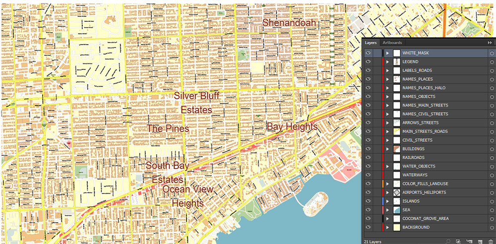
Printable Vector Map of Coconut Grove Miami Florida US detailed street map scale 1:4224 fully editable Layered Adobe Illustrator + PDF in 1 archive scalable, text format all names, 9 MB ZIP
All street names, Main Objects, Buildings. Map for design, printing, arts, projects, presentations, for architects, designers, and builders, business, logistics.
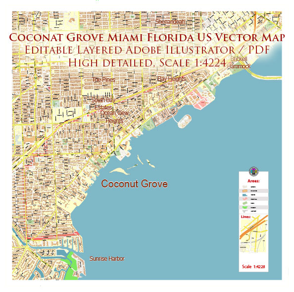
Coconut Grove Miami Florida US Map Vector Exact City Plan High Detailed Street Map editable Adobe Illustrator and PDF in layers
Layers list:
- Legend
- Labels of roads
- Names of places (city, hamlet, etc.)
- Names of objects (parks, water)
- Names of main streets
- Names of civil streets
- Arrows of streets
- Main Streets, roads
- Civil streets
- Buildings
- Water objects (rivers, lakes, ponds)
- Waterways
- Color fills (parks, land use, etc.)
- Islands
- Sea
- Coconut Grove Boundaries
- Background
The most exact and detailed map of the city in scale.
For Editing and High-Quality Printing
Coconut Grove Miami Florida US Map Vector Exact City Plan High Detailed Street Map editable Adobe Illustrator and PDF in layers
Coconut Grove Miami Florida US Map Vector Exact City Plan High Detailed Street Map editable Adobe Illustrator and PDF in layers
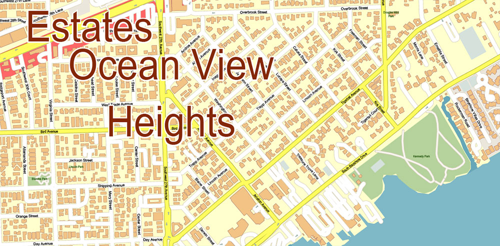
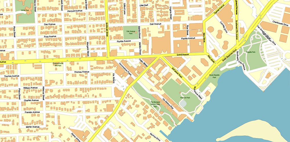
Detailed geographical description of the Coconut Grove Miami Florida + main streets
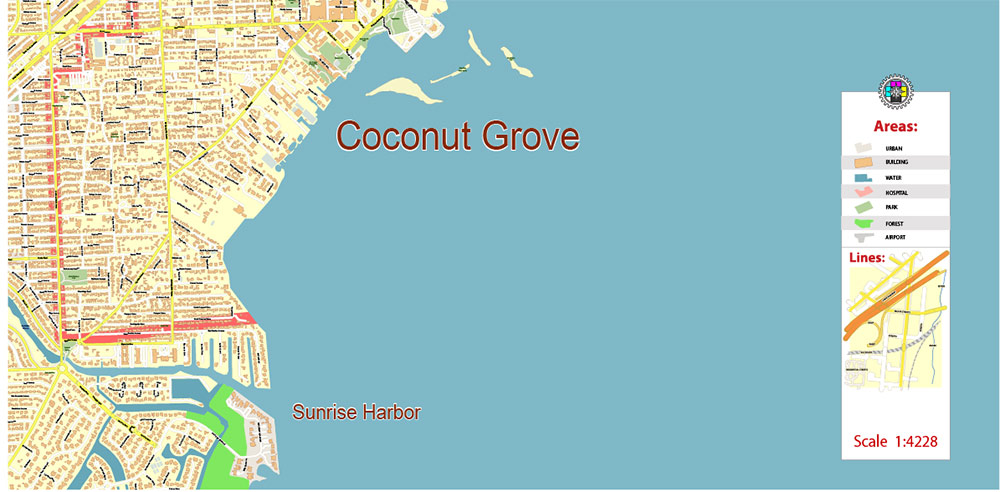
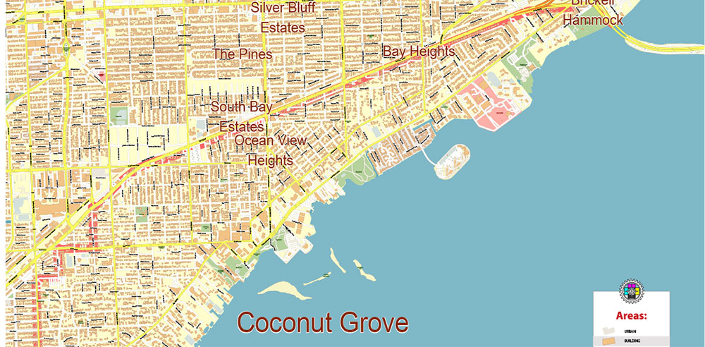
Coconut Grove, often called “The Grove,” is Miami’s oldest continuously inhabited neighborhood, located in Miami-Dade County, Florida. It is an affluent, lush, and bayside community known for its tropical vibe, historic charm, and green spaces.
Geographical Boundaries
Coconut Grove is roughly bounded by:
North: South Dixie Highway (US 1) and the Rickenbacker Causeway
South: North Prospect Drive (City of Miami boundary)
West: LeJeune Road (Southwest 42nd Avenue)
East: Biscayne Bay
It lies south of Brickell and The Roads neighborhoods and east of Coral Gables.
Area and Population
The neighborhood covers about 5.6 square miles and corresponds approximately to the 33133 ZIP Code, though the ZIP extends slightly into Coral Gables and Coral Way. The population is around 19,000 residents, with a diverse demographic including a significant portion of foreign-born residents and a historic Black community with Bahamian roots dating back to the 1870s.
Main Streets and Key Roads
Coconut Grove’s street layout includes several important thoroughfares and charming residential streets:
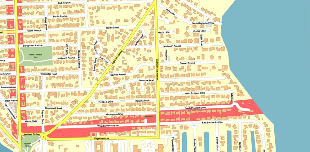
Main Highway (South Bayshore Drive/Ingraham Highway/Old Cutler Road): A major scenic road running along the bay, central to the neighborhood’s character and lined with historic homes and green spaces.
Grand Avenue: A key commercial and cultural street intersecting with Main Highway and McFarlane Road, forming the historic heart of Coconut Grove’s village center.
McFarlane Road: Runs parallel to Grand Avenue and Main Highway, also part of the vibrant commercial and dining district near the waterfront.
Virginia Street: Known as a quiet shortcut near Dixie Highway, with residential charm and access to local shops.
Florida Avenue: A lively street with a mix of residential and bazaar-style shopping, known for its vibrant nighttime atmosphere.
South Dixie Highway (US 1): Forms the northern boundary and serves as a major arterial road connecting Coconut Grove to downtown Miami and other neighborhoods.
LeJeune Road (SW 42nd Avenue): Marks the western boundary and connects to Coral Gables and Miami International Airport area.
Tigertail Avenue and Mary Street: Leafy, pedestrian-friendly streets with shops, cafes, and cultural venues near the waterfront.
27th Avenue (SW 27th Avenue): Runs north-south through the neighborhood and is served by public transit, including the Metrorail station.
Neighborhood Character and Landmarks
Coconut Grove is known for its dense canopy of banyan trees, palms, and live oaks lining quiet residential streets. The neighborhood blends historic homes, tropical gardens, and a lively commercial core with boutiques, restaurants, and cultural sites.
Parks and Nature
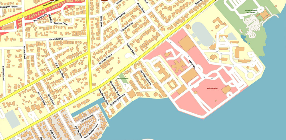
The Barnacle Historic State Park: The oldest home in Miami-Dade County still in its original location, surrounded by tropical hardwood hammock and situated on Biscayne Bay.
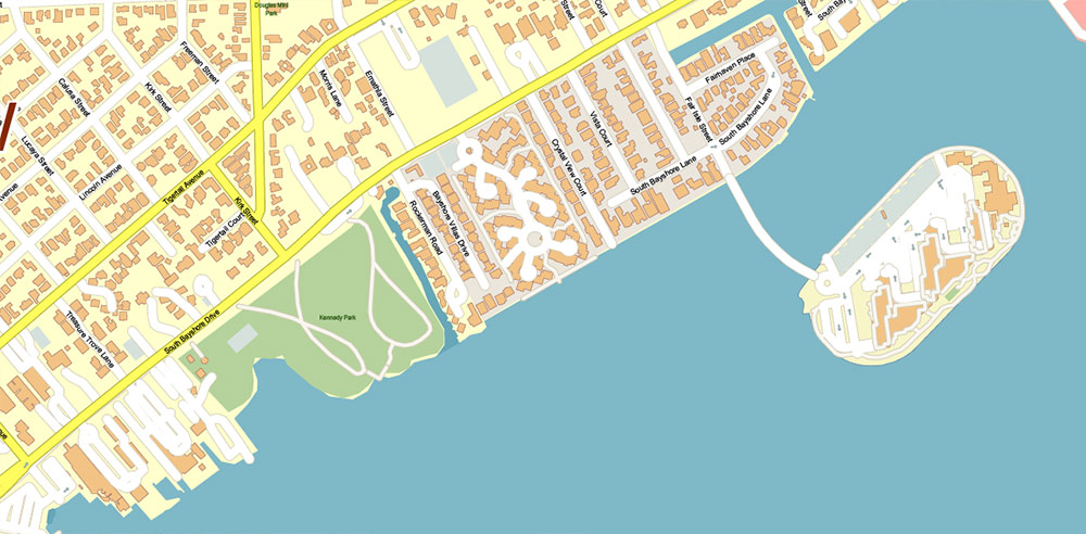
Peacock Park and David T. Kennedy Park: Popular waterfront parks hosting sailing events and community gatherings.
The Kampong: A tropical botanical garden that is part of the National Tropical Botanical Garden.
Other parks include Merrie Christmas Park, Steele Park, Blanche Park, and Alice Wainwright Park.
Cultural and Commercial Areas
CocoWalk: A three-story open-air shopping, dining, and entertainment complex, a central hub for locals and visitors.
Historic Village Center: Around the intersection of Grand Avenue, McFarlane Road, and Main Highway, featuring shops, restaurants, and historic sites including the former Coconut Grove Bank building.
Dinner Key Marina: A major boating center reflecting the neighborhood’s strong maritime culture.
Vizcaya Museum and Gardens: Nearby historic estate and gardens, a major cultural attraction.
Transportation
Coconut Grove is well connected by major roads such as US 1 and Main Highway. The Miami Metrorail serves the area with stations at Coconut Grove, Douglas Road, and nearby SW 27th and 32nd Avenues. Several bus lines also serve the neighborhood, making it accessible without a car, though renting a car is recommended for full exploration.
In summary, Coconut Grove is a picturesque, historic, and vibrant neighborhood in Miami, bounded by Biscayne Bay, US 1, LeJeune Road, and North Prospect Drive. Its main streets—Main Highway, Grand Avenue, McFarlane Road, and Florida Avenue—form the core of its commercial and cultural life, while the leafy residential streets and waterfront parks contribute to its lush, tropical atmosphere. The neighborhood is a blend of history, nature, and modern urban life, making it a unique and cherished part of Miami.
Coconut Grove Miami Florida US Map Vector Exact City Plan High Detailed Street Map editable Adobe Illustrator and PDF in layers
Coconut Grove Miami Florida US Map Vector Exact City Plan High Detailed Street Map editable Adobe Illustrator and PDF in layers
Coconut Grove Miami Florida US Map Vector Exact City Plan High Detailed Street Map editable Adobe Illustrator and PDF in layers
Coconut Grove Miami Florida US Map Vector Exact City Plan High Detailed Street Map editable Adobe Illustrator and PDF in layers
Coconut Grove Miami Florida US Map Vector Exact City Plan High Detailed Street Map editable Adobe Illustrator and PDF in layers
Coconut Grove Miami Florida US Map Vector Exact City Plan High Detailed Street Map editable Adobe Illustrator and PDF in layers

 Author: Kirill Shrayber, Ph.D. FRGS


