Extended Description of the Vector Map
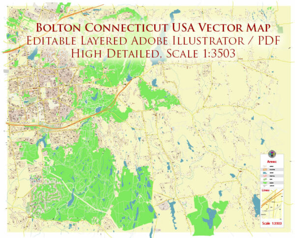
Printable PDF Vector Map of Bolton Connecticut USA detailed City Plan scale 1:3503 full editable Adobe PDF scalable, text / curves format all names, 16 MB ZIP
All street names, Main Objects, Buildings. Map for design, printing, arts, projects, presentations, for architects, designers, and builders, business, logistics.

Bolton Connecticut USA PDF Map Vector Exact City Plan High Detailed Street Map editable Adobe PDF in layers
Layers list:
- Legend
- Grids
- Labels of roads
- Names of places (city, hamlet, etc.)
- Names of objects (hospitals, parks, water)
- Names of main streets
- Names of civil streets
- Arrows of streets
- Main Streets, roads
- Civil streets
- Buildings
- Water objects (rivers, lakes, ponds)
- Waterways
- Color fills (parks, hospital areas, land use, etc.)
- Background
The most exact and detailed map of the city in scale.
For Editing and High-Quality Printing
Bolton, Connecticut, is a small town located in Tolland County in the northeastern part of the state. It is part of the Capitol Planning Region and is situated about 12 miles east of Hartford, the state capital. Here’s a detailed geographical description of Bolton:
General Location and Boundaries
-
Coordinates: Approximately 41.768°N latitude and 72.434°W longitude.
-
Region: Northeastern Connecticut, part of the Capitol Planning Region (formerly the Capitol Region Council of Governments).
-
Neighboring Towns:
-
North: Vernon
-
East: Tolland and Coventry
-
South: Andover and Hebron
-
West: Manchester and Glastonbury (via rural borders)
Topography and Land Features
-
Area: Roughly 14.7 square miles (38.1 km²)
-
Terrain: Hilly and forested, with numerous small ridges, valleys, and drumlins formed by glacial activity.
-
Elevation: Generally varies between 400 to 800 feet (122 to 244 meters) above sea level.
Natural Features
-
Forests: Bolton is heavily wooded, and much of the land remains rural or semi-rural with oak, maple, and birch dominating the forest cover.
-
Water Bodies:
-
Bolton Lake (Lower, Middle, and Upper): A chain of lakes on the eastern side, partly shared with Vernon and Coventry, used for recreation.
-
Railroad Brook and Roaring Brook: Small tributaries that contribute to the local watershed, feeding into the Hop River and eventually the Thames River.
-
Soil: Predominantly sandy loam and glacial till, supporting agriculture and forestry in certain areas.
Development and Land Use
-
Residential: Primarily low-density single-family homes.
-
Agriculture: Some open land still in use for small-scale farming and orchards.
-
Commercial: Limited commercial activity concentrated along Route 44 and Route 6.
-
Preserved Land: Bolton Notch State Park and the Hop River State Park Trail are key recreational and conservation areas.
Transportation and Roads
-
Major Roads:
-
U.S. Route 6: Runs east-west through Bolton, part of the historic transcontinental route.
-
U.S. Route 44: Merges with Route 6 through part of the town, a key corridor toward Hartford and Putnam.
-
Interstate 384: Passes just north of town (via Manchester), providing fast access to Hartford and I-84.
-
Trails:
-
Hop River State Park Trail: A popular multi-use trail running along a former rail bed, connecting to Manchester and Columbia.
-
Shenipsit Trail: A long-distance hiking trail that skirts through parts of Bolton’s wooded areas.
Climate
-
Type: Humid continental climate.
-
Winters: Cold and snowy, with average lows in the teens (°F).
-
Summers: Warm and humid, with average highs in the low to mid-80s (°F).
-
Precipitation: Evenly distributed throughout the year, with occasional Nor’easters in winter and thunderstorms in summer.
Notable Geographic & Recreational Sites
-
Bolton Notch State Park: A scenic park with exposed rock formations, caves, and panoramic views, popular for hiking and picnicking.
-
Freja Park: A small park with trail access connecting to larger trail systems.
-
Valley Falls Park (nearby in Vernon): Often visited by Bolton residents for hiking and fishing.
Geographic Character Summary
Bolton combines rural New England charm with natural beauty and accessibility. Its landscape is shaped by glacial features and wooded hills, with a relatively undeveloped feel despite being close to major highways and urban centers. Outdoor recreation is deeply tied to its geography, with hiking, biking, fishing, and scenic drives being central to its identity.

Bolton Connecticut USA PDF Map Vector Exact City Plan High Detailed Street Map editable Adobe PDF in layers

Bolton Connecticut USA PDF Map Vector Exact City Plan High Detailed Street Map editable Adobe PDF in layers

Bolton Connecticut USA PDF Map Vector Exact City Plan High Detailed Street Map editable Adobe PDF in layers

Bolton Connecticut USA PDF Map Vector Exact City Plan High Detailed Street Map editable Adobe PDF in layers

Bolton Connecticut USA PDF Map Vector Exact City Plan High Detailed Street Map editable Adobe PDF in layers


 Author: Kirill Shrayber, Ph.D. FRGS


