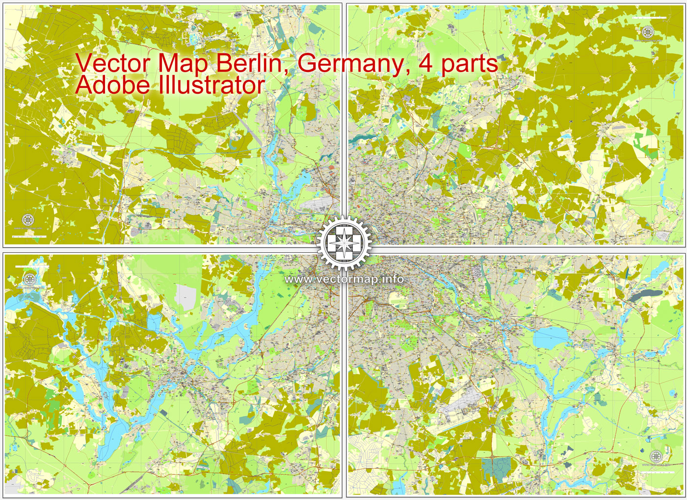
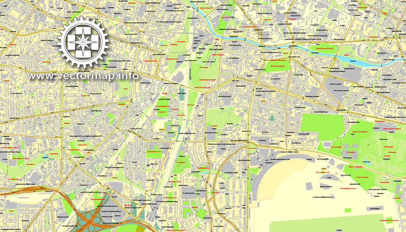
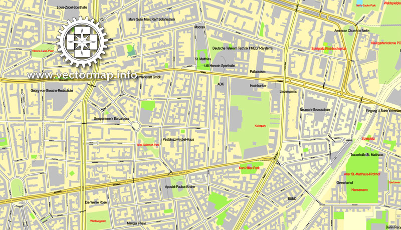
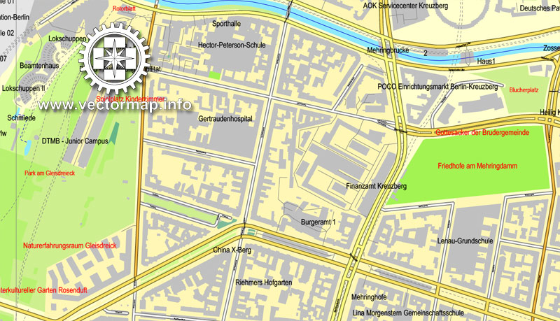
Berlin, Germany, printable vector street map City Plan in 4 parts, full editable, Adobe illustrator, full vector, scalable, editable, text format street names, 56,7 mb ZIP
All streets, All buildings. Map for design, print, arts, projects, presentations, for architects, designers and builders.
PDF, DXF, DWG, CDR and other formats – on request, same price, please, contact
Berlin, Deutschland, Straße druckbare Vektorkarte Stadtplan in 4 Teile, voll editierbar, Adobe Illustrator, voll Vektor, skalierbare, editierbare, Textformat Straßennamen , 56,7 mb ZIP
Alle Straßen, alle Gebäude. Karte für Design, Druck, Kunst, Projekte, Präsentationen,
für Architekten, Planer und Bauherren.
PDF, DXF, DWG, CDR und andere Formate – auf Anfrage, gleicher Preis, kontaktieren Sie
Berlin, Germany.
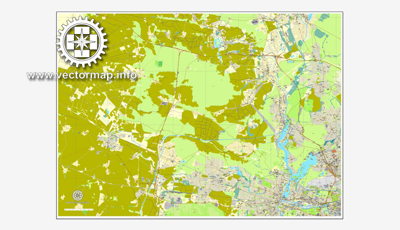
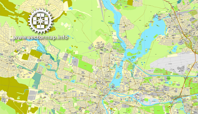
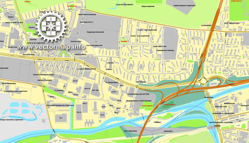
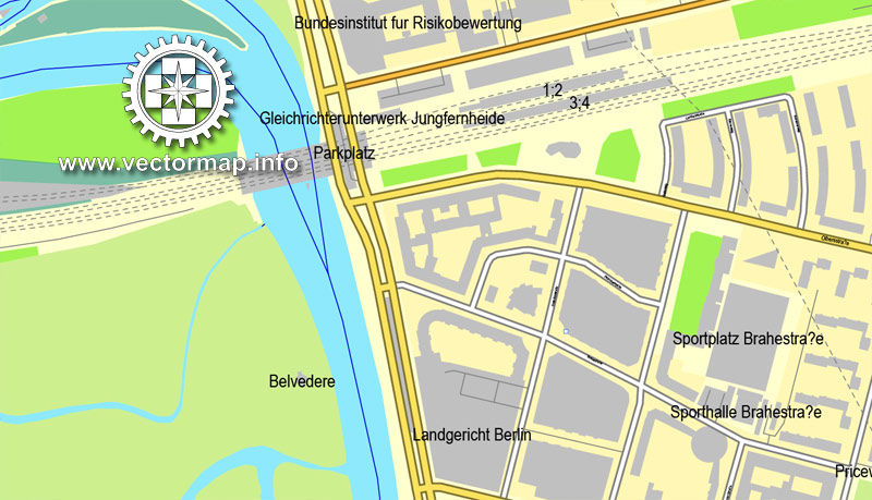
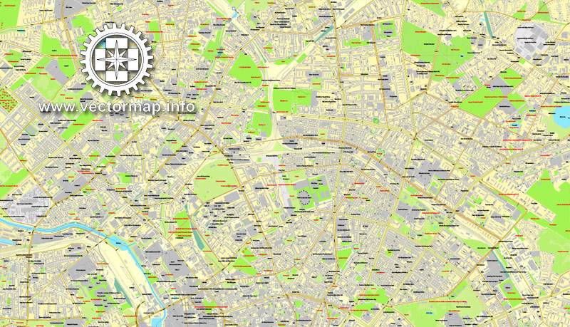
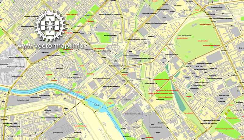
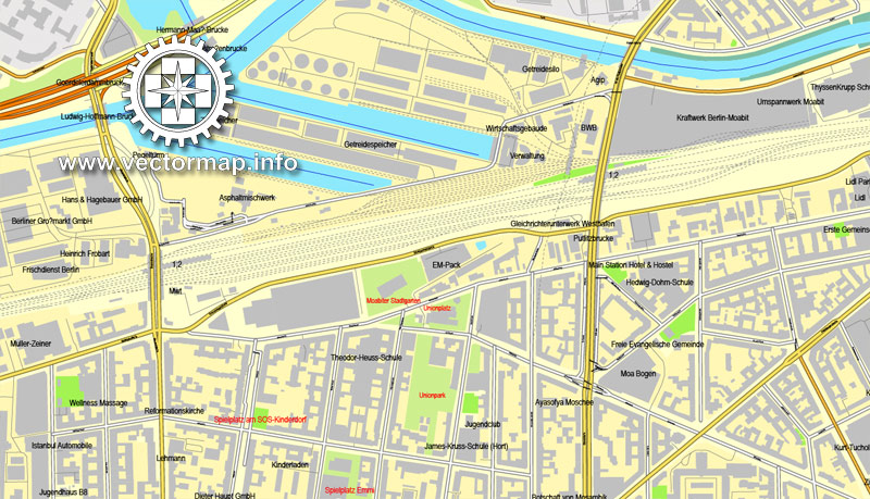
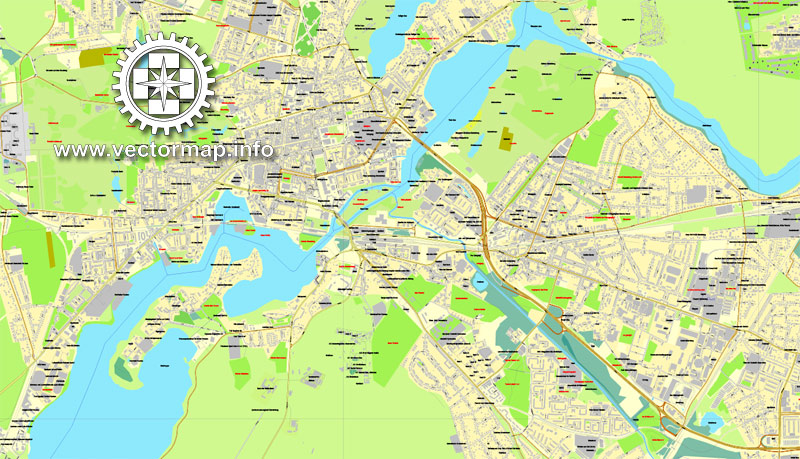
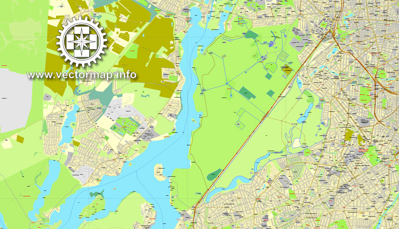
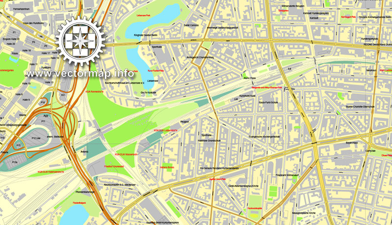
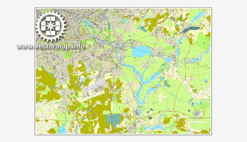
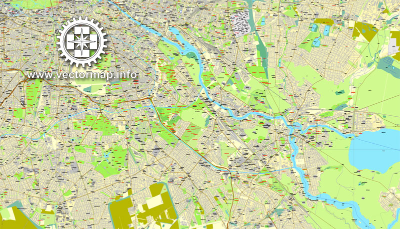
This vector map of Berlin city is used as a basis for design, editing, and further printing.
This is the most detailed, exact map of Berlin city for high-quality printing and polygraphy. You can always clarify the map development date by contacting us.
You can easily add any objects needed (e.g. shops, salons, sale points, gas station or attraction) on any layer of Berlin vector map.
Berlin is the capital and largest city of Germany by both area and population. Its 3,711,930 (2017) inhabitants make it the second most populous city proper of the European Union after London. The city is one of Germany’s 16 federal states, and it is surrounded by the state of Brandenburg, the capital of which, Potsdam, is contiguous with Berlin.
One of the advantages of Berlin city vector maps of our production is the relevance of cartographic data, we constantly update all our products.
This vector map of Berlin city is used by:
designers, layout designers, printers, advertisers and architects. Our product – vector maps – is designed for further editing and printing in large formats – from @Wall format (a few meters) to A-0 and A-1, A-2, A-3.
The two cities are at the center of the Berlin/Brandenburg Metropolitan Region, which is, with 6,004,857 (2015) inhabitants, Germany’s third-largest metropolitan region after the Rhine-Ruhr and Rhine-Main regions. Berlin Tegel airport is the fourth busiest in Germany.
The advertising and presentation map of Berlin city (usually the final designer marks the routes, and puts the client’s objects (shops, saloons, gas stations etc.)
The undoubted advantage is that people will NEVER throw out this advertising product – the map. In fact, as an advertising medium, a city map is the most “long-playing” of the well-known polygraphic advertising media, with the longest lifespan, and the maximum number of interactions with the customer.
Berlin straddles the banks of the River Spree, which flows into the River Havel (a tributary of the River Elbe) in the western borough of Spandau. Among the city’s main topographical features are the many lakes in the western and southeastern boroughs, formed by the Spree, Havel, and Dahme rivers, the largest of which is Lake Müggelsee. Due to its location in the European Plain, Berlin is influenced by a temperate seasonal climate.
For travelers, maps are sold at the airports and gas stations around the world. Often the source is our vector maps.
Take a look, who purchases our vector maps of Berlin city in “Our Clients and Friends” page – these are large and small companies, from super-brands like Volvo and Starbucks, to small design studios and printing houses.
About one-third of the city’s area is composed of forests, parks, gardens, rivers, canals and lakes. The city lies in the Central German dialect area, the Berlin dialect being a variant of the Lusatian-New Marchian dialects.
It’s very easy to work with vector maps of Berlin city, even for a not very experienced designer who can turn on and off the map layers, add new objects, change the colors of fill and lines according to customer requirements.
The undoubted advantage of Berlin city vector maps in printing is an excellent and detailed visualization, when customer can expand a large paper map and instantly define his location, find a landmark, an object or address on map, unlike using the popular electronic formats of Google and Yandex maps for example.
First documented in the 13th century and situated at the crossing of two important historic trade routes, Berlin became the capital of the Margraviate of Brandenburg (1417–1701), the Kingdom of Prussia (1701–1918), the German Empire (1871–1918), the Weimar Republic (1919–1933), and the Third Reich (1933–1945).
Printable vector maps of Berlin city are much more convenient and efficient than any electronic maps on your smartphone, because ALL DETAILS are displayed in the entire space of Berlin city map.
Berlin in the 1920s was the third largest municipality in the world. After World War II and its subsequent occupation by the victorious countries, the city was divided; West Berlin became a de facto West German exclave, surrounded by the Berlin Wall (1961–1989) and East German territory. East Berlin was declared capital of East Germany, while Bonn became the West German capital. Following German reunification in 1990, Berlin once again became the capital of all of Germany.
Useful tips on working with vector maps of cities and countries in Adobe Illustrator.
«V» – launches the Selection tool (cursor, black arrow), which makes active any vector line.
«А» – launches the Direct Selection tool (white cursor), allows you to select curve elements and drag them to the desired place.
«R» – activates the Rotate tool, which helps you rotating selected objects around the center point by 360 degrees.
«E» – gives you the opportunity to use the Eraser tool and erase unnecessary parts.
«X» – switches between Fill and Stroke in the Tools section. Try to get used to this hot key and
you will quickly understand that you can’t live and work without it.
Berlin is a world city of culture, politics, media and science. Its economy is based on high-tech firms and the service sector, encompassing a diverse range of creative industries, research facilities, media corporations and convention venues. Berlin serves as a continental hub for air and rail traffic and has a highly complex public transportation network. The metropolis is a popular tourist destination. Significant industries also include IT, pharmaceuticals, biomedical engineering, clean tech, biotechnology, construction and electronics.
Guides are not limited to vertical and horizontal in Adobe Illustrator. You can also create a diagonal guide for example. Moreover, you can turn any contours into guides. Select the outline and go to View > Guides > Make Guides (Create Guides), or simply press Cmd/Ctrl + 5. You can also turn the guides back into an editable object. Go to menu, View > Guides > Unlock Guides (Release Guides), select the guide you want to edit and select View > Guides > Release Guides (Reset Guides), or just press Cmd/Ctrl + Option / Alt + 5).
Berlin is home to world-renowned universities, orchestras, museums, and entertainment venues, and is host to many sporting events. Its Zoological Garden is the most visited zoo in Europe and one of the most popular worldwide. With the world’s oldest large-scale movie studio complex, Berlin is an increasingly popular location for international film productions. The city is well known for its festivals, diverse architecture, nightlife, contemporary arts and a very high quality of living. Since the 2000s Berlin has seen the emergence of a cosmopolitan entrepreneurial scene.
You will probably want to change the color scheme used on our Berlin vector city map.
To quickly and effectively play with colors.
Of course, you can do it manually, all objects in our Berlin city vector map are divided according to types and layers, and you can easily change the color gamma of vector objects in groups and layers.
Topography
Berlin is situated in northeastern Germany, in an area of low-lying marshy woodlands with a mainly flat topography, part of the vast Northern European Plain which stretches all the way from northern France to western Russia.
But there is more effective way of working with the whole VECTOR MAP of Berlin city and all layers:
The overview dialog «Edit colors»/«Repaint Graphic Object» (this dialog box name can change depending on the context):
If you have selected a part or a layer of Berlin city vector map and open the dialog box by clicking the icon in the Control panel, on the Samples palette or the Color Catalog, or if you choose Edit > Edit Colors> Repaint Graphic Object, then the «Repaint Graphic Object» dialog box appears, and you get access to «Assign» and «Edit» tabs.
The Berliner Urstromtal (an ice age glacial valley), between the low Barnim Plateau to the north and the Teltow Plateau to the south, was formed by meltwater flowing from ice sheets at the end of the last Weichselian glaciation.
If a picture or a map fragment is not selected, and you open the dialog box by clicking the icon in the Control panel, on the Samples palette or in the Color Catalog, the «Edit Colors» dialog box appears and you can only access the «Edit» tab.
Regardless of the name at the top of the dialog box, the right-hand side always displays the color group of the current document, as well as two default color groups: Print Color and Grayscale. These color groups can be selected and used any time.
The Spree follows this valley now. In Spandau, a borough in the west of Berlin, the Spree empties into the river Havel, which flows from north to south through western Berlin. The course of the Havel is more like a chain of lakes, the largest being the Tegeler See and the Großer Wannsee. A series of lakes also feeds into the upper Spree, which flows through the Großer Müggelsee in eastern Berlin.
Create and edit color groups of Berlin city vector map, and also assign colors using the «Edit Colors»/ а «Repaint Graphic Object» dialog box.
A. Creating and editing of a color group on the «Edit» tab
B. Assigning colors on the «Assign» tab
C. Select a group of colors from the «Color groups» list
The option «Repaint a graphic object» in the lower part of the dialog box allows you to preview the colors on a selected layer of Vector map, or a group of elements, and specify whether its colors will be redefined when the dialog box is closed.
Substantial parts of present-day Berlin extend onto the low plateaus on both sides of the Spree Valley. Large parts of the boroughs Reinickendorf and Pankow lie on the Barnim Plateau, while most of the boroughs of Charlottenburg-Wilmersdorf, Steglitz-Zehlendorf, Tempelhof-Schöneberg, and Neukölln lie on the Teltow Plateau.
The main areas of the dialog box are:
«Edit»
The «Edit» tab is designed to create a new or edit the existing color groups.
The harmony rules Menu and the Color Wheel are used to conduct experiments with color harmonies. The color wheel shows how colors are related in color harmony, and the color bars allow you to view and manipulate an individual color values. In addition, you can adjust the brightness, add and remove colors, save color groups and view colors on the selected Vector Map of Berlin city or a separated layers.
The borough of Spandau lies partly within the Berlin Glacial Valley and partly on the Nauen Plain, which stretches to the west of Berlin. Since 2015, the highest elevation in Berlin is found on the Arkenberge hills in Pankow, at 122 metres (400 feet). Through the dumping of construction debris, they surpassed Teufelsberg (120.1 m or 394 ft), a hill made of rubble from the ruins of the Second World War. The highest natural elevation is found on the Müggelberge at 114.7 metres (376 feet), and the lowest at the Spektesee in Spandau, at 28.1 metres (92 feet).
«Assign»
The «Assign» tab is used to view and control on how the original colors are replaced with colors from the color group like your corporate colors in the Vector Map of Berlin city.
The assign color ability is provided only if the entire map, layer or fragment is selected in the document. You can specify which of new colors replace the current colors, whether the spot colors should be preserved and how colors are replaced (for example, you can replace colors completely or changing the color tone while maintaining the brightness). The «Assign» tab allows you to redefine colors in the Vector Map of Berlin city, or in separate layers and fragments using the current color group or reducing the number of colors in the current Vector Map.
Boroughs
Berlin is subdivided into 12 boroughs or districts (Bezirke). Each borough is made up by a number of subdistricts or neighborhoods (Ortsteile), which have historic roots in much older municipalities that predate the formation of Greater Berlin on 1 October 1920. These subdistricts became urbanized and incorporated into the city later on. Many residents strongly identify with their neighbourhoods, colloquially called Kiez. At present, Berlin consists of 96 subdistricts, which are commonly made up of several smaller residential areas or quarters.
Color groups
Is a list of all saved color groups for current document (the same groups appear in the «Samples» palette). You can edit and delete the existing color groups, as well as creating a new ones using the list of “Color Groups” in the dialog box. All changes appear in the «Samples» palette.
The highlighted color group shows, which color group is currently edited.
Any color group can be selected and edited, or used to redefine the colors in the selected vector map of Berlin city, its fragments or elements.
Each borough is governed by a borough council (Bezirksamt) consisting of five councilors (Bezirksstadträte) including the borough’s mayor (Bezirksbürgermeister). The council is elected by the borough assembly (Bezirksverordnetenversammlung). However, the individual boroughs are not independent municipalities, but subordinate to the Senate of Berlin. The borough’s mayors make up the council of mayors (Rat der Bürgermeister), which is led by the city’s Governing Mayor and advises the Senate. The neighborhoods have no local government bodies.
Saving a color group adds this group to the specified list.
Opening the «Edit Colors»/«Repaint Graphic Object» dialog box.
Open the «Edit Colors»/«Repaint Graphic Object» dialog box using one of the following methods:
«Edit»> «Edit Colors»> «Repaint Graphic object» or «Repaint With Style».
Use these commands if you need to edit the colors in the selected vector map of Berlin city.
«Repaint Graphic object» button on the «Control» panel.
Use this button if you need to adjust colors of Berlin city vector map using the а «Repaint graphic object» dialog box.
The specified button is available if the selected vector map or its fragment contains two or more colors.
Note. This color editing method is convenient for global color adjustment in a vector map, if global colors were not used when creating a City Map of Berlin.
The «Edit colors» button or «Edit or apply colors» on the «Color Catalog» palette
Click this button if you need to edit colors on the «Color Catalog» palette or edit and then apply them to the selected Vector Map of Berlin city or its fragment.
The «Edit color group» button or «Edit or apply color group» on the «Samples» palette.
Click this button if you need to edit the colors in the specific color group or edit and apply them to the selected Vector Map of Berlin city or a group of its elements, for example, the whole layer “Streets and lines”. You can also double-click the color group in the Samples panel to open the dialog box.
If the map file is too large and your computer freezes or even can’t open it quickly:
1. Try to reduce the color resolution of the video card (display) to 256 colors while working with a large map.
2. Using Windows Task Manager, select all the application you don’t need, while working with map, just turn them off.
3. Launch Adobe Illustrator. (DO NOT OPEN the vector map file)
4. Start the Windows Task Manager using administrator rights > Find the “Illustrator” process > set the «real time» priority,
5. Open the file. When you see the LEGACY FONT popup window – click “OK” (do not update). You can restore the TEXT later.
6. Can also be useful: When file is opened – Edit > Settings > Basic Settings > disable smoothing. /// It looks scary, but works quickly)))
We recommend saving the file in Adobe Illustrator 10 version. It’s much more stable when working with VERY BIG size files.
Small guide:
You can: Mass select objects by type and color – for example, the objects type “building” (they are usually dark gray) – and remove them from the map, if you do not need them in your print or design project. You can also easily change the thickness of lines (streets), just bulk selection the road by the line color.
The streets are separated by type, for example, type “residential road” are usually white with a gray stroke. Highway usually orange with a brown or dark gray stroke.
It is easy to change the font of inscriptions, all or each individually. Also, just can be make and any other manipulation of objects on the vector map in Adobe illustrator format.
Important: All the proportions on the map are true, that is, the relative sizes of the objects are true, because Map is based on an accurate GPS projection, and It transated into the (usual for all) the Mercator projection.
You can easily change the color, stroke and fill of any object on the map, zoom without loss of quality Image Verification.

 Author: Kirill Shrayber, Ph.D. FRGS
 Street Map editable Adobe Illustrator in layers")

