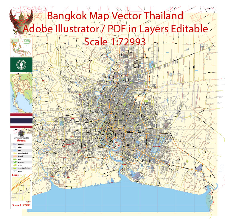
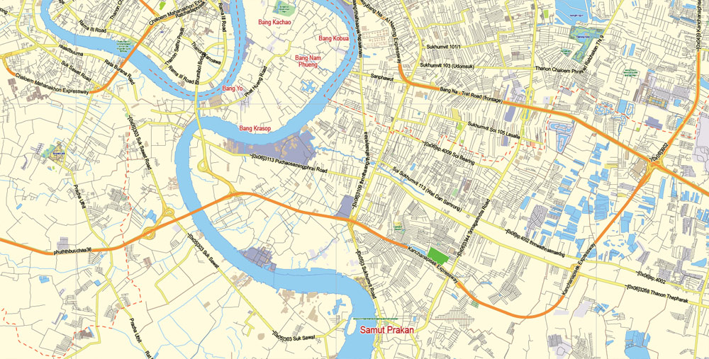
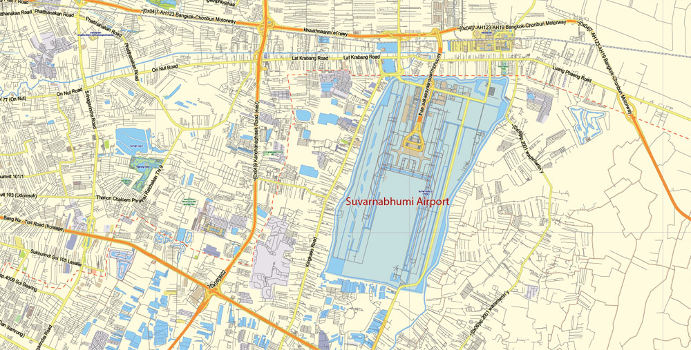
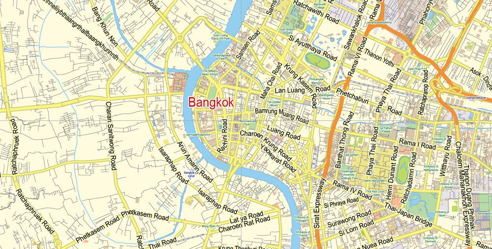
Printable Vector Map of Bangkok Thailand ENG low detailed City Plan for small print size scale 1:72993 full editable Adobe Illustrator Street Map in layers , scalable, editable text format all names, 14 mb ZIP
Main streets names, Main Objects, Principal Buildings. Map for design, printing, arts, projects, presentations, for architects, designers and builders, business, logistics. English names.
Layers: color_fills, streets_roads, labels_roads, names_objects, names_streets, names_places, water, buildings, grids, legend.
The most exact and detailed map of the city in scale.
For Editing and High Quality Printing in small size
DWG, DXF and other formats – on request, same price, please, contact
Bangkok is the capital and most populous city of Thailand. The city occupies 1,568.7 square kilometres (605.7 sq mi) in the Chao Phraya River delta in central Thailand, and has a population of over eight million, or 12.6 percent of the country’s population.
You can easily add any objects needed (e.g. shops, salons, sale points, gas station or attraction) on any layer of Bangkok vector map.
Over fourteen million people (22.2 percent) lived within the surrounding Bangkok Metropolitan Region at the 2010 census, making Bangkok the nation’s primate city, significantly dwarfing Thailand’s other urban centres in terms of importance.
Bangkok traces its roots to a small trading post during the Ayutthaya Kingdom in the 15th century, which eventually grew and became the site of two capital cities: Thonburi in 1768 and Rattanakosin in 1782. Bangkok was at the heart of the modernization of Siam, later renamed Thailand, during the late 19th century, as the country faced pressures from the West.
For travelers, maps are sold at the airports and gas stations around the world. Often the source is our vector maps.
The city was at the centre of Thailand’s political struggles throughout the 20th century, as the country abolished absolute monarchy, adopted constitutional rule, and underwent numerous coups and several uprisings.
Create and edit color groups of Bangkok city vector map, and also assign colors using the «Edit Colors»/ а «Repaint Graphic Object» dialog box.
A. Creating and editing of a color group on the «Edit» tab
B. Assigning colors on the «Assign» tab
C. Select a group of colors from the «Color groups» list
The option «Repaint a graphic object» in the lower part of the dialog box allows you to preview the colors on a selected layer of Vector map, or a group of elements, and specify whether its colors will be redefined when the dialog box is closed.
Take a look, who purchases our vector maps of Bangkok city in “Our Clients and Friends” page – these are large and small companies, from super-brands like Volvo and Starbucks, to small design studios and printing houses.
The city grew rapidly during the 1960s through the 1980s and now exerts a significant impact on Thailand’s politics, economy, education, media and modern society.
The Asian investment boom in the 1980s and 1990s led many multinational corporations to locate their regional headquarters in Bangkok. The city is now a regional force in finance and business. It is an international hub for transport and health care, and has emerged as a centre for the arts, fashion, and entertainment.
Use these commands if you need to edit the colors in the selected vector map of Bangkok city.
«Repaint Graphic object» button on the «Control» panel.
Use this button if you need to adjust colors of Bangkok city vector map using the а «Repaint graphic object» dialog box.
The specified button is available if the selected vector map or its fragment contains two or more colors.
Note. This color editing method is convenient for global color adjustment in a vector map, if global colors were not used when creating a City Map of Bangkok.
The «Edit colors» button or «Edit or apply colors» on the «Color Catalog» palette
Click this button if you need to edit colors on the «Color Catalog» palette or edit and then apply them to the selected Vector Map of Bangkok city or its fragment.
The city is known for its vibrant street life and cultural landmarks, as well as its notorious red-light districts. The historic Grand Palace and Buddhist temples including Wat Arun and Wat Pho stand in contrast with other tourist attractions such as the nightlife scenes of Khaosan Road and Patpong. Bangkok is among the world’s top tourist destinations, and has been named the world’s most visited city in multiple rankings.
Bangkok’s rapid growth coupled with little urban planning has resulted in a haphazard cityscape and inadequate infrastructure.
If a picture or a map fragment is not selected, and you open the dialog box by clicking the icon in the Control panel, on the Samples palette or in the Color Catalog, the «Edit Colors» dialog box appears and you can only access the «Edit» tab.
Regardless of the name at the top of the dialog box, the right-hand side always displays the color group of the current document, as well as two default color groups: Print Color and Grayscale. These color groups can be selected and used any time.
For your convenience, all objects on Bangkok vector city map are divided into layers. And the editing is very easy – colors, lines, etc.
An inadequate road network, despite an extensive expressway network, together with substantial private car usage, have led to chronic and crippling traffic congestion, which caused severe air pollution in the 1990s. The city has since turned to public transport in an attempt to solve the problem.
Any color group can be selected and edited, or used to redefine the colors in the selected vector map of Bangkok city, its fragments or elements.
Saving a color group adds this group to the specified list.
Opening the «Edit Colors»/«Repaint Graphic Object» dialog box.
Open the «Edit Colors»/«Repaint Graphic Object» dialog box using one of the following methods:
«Edit»> «Edit Colors»> «Repaint Graphic object» or «Repaint With Style».
Five rapid transit lines are now in operation, with more systems under construction or planned by the national government and the Bangkok Metropolitan Administration.
Geography
Satellite image showing a river flowing into the ocean, with large built-up areas along its sides just before the river mouth
Bangkok city proper covers an area of 1,568.7 square kilometres (605.7 sq mi), ranking 69th among the other 76 provinces of Thailand.
But there is more effective way of working with the whole VECTOR MAP of Bangkok city and all layers:
The overview dialog «Edit colors»/«Repaint Graphic Object» (this dialog box name can change depending on the context):
If you have selected a part or a layer of Bangkok city vector map and open the dialog box by clicking the icon in the Control panel, on the Samples palette or the Color Catalog, or if you choose Edit > Edit Colors> Repaint Graphic Object, then the «Repaint Graphic Object» dialog box appears, and you get access to «Assign» and «Edit» tabs.
Of this, about 700 square kilometres (270 sq mi) form the built-up urban area. It is ranked 73rd in the world in terms of land area by City Mayors.
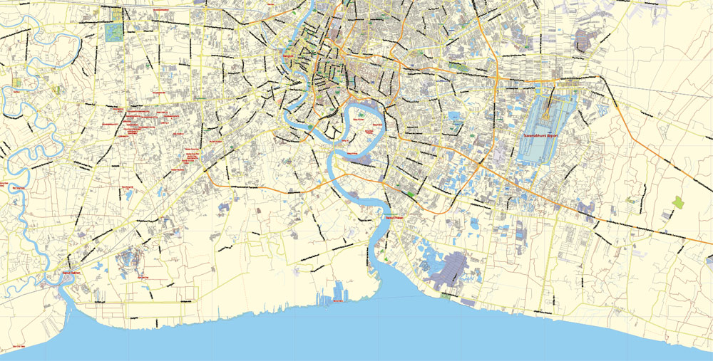
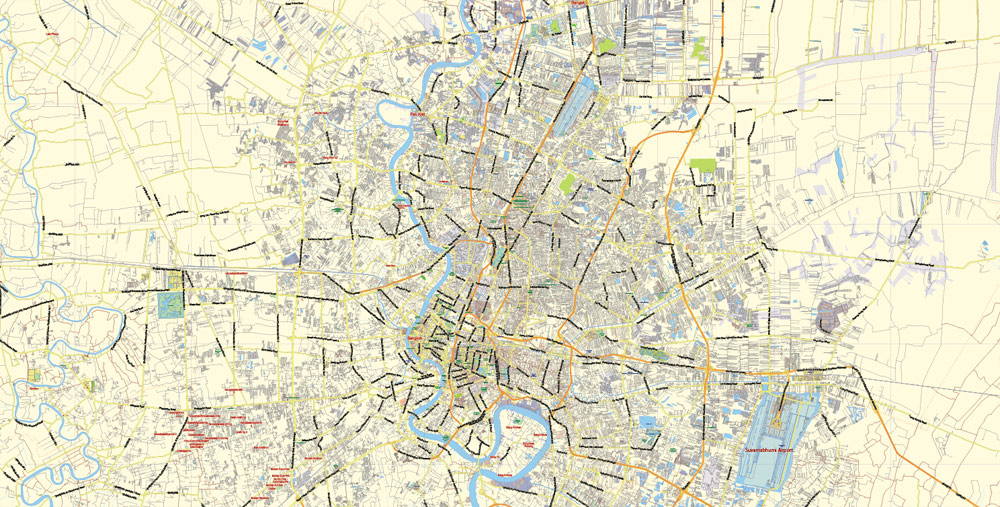
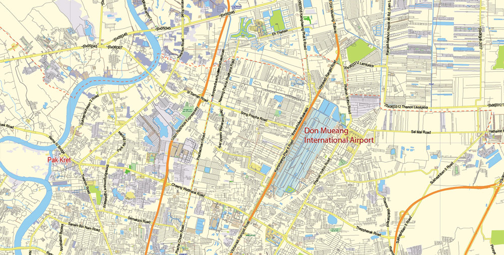
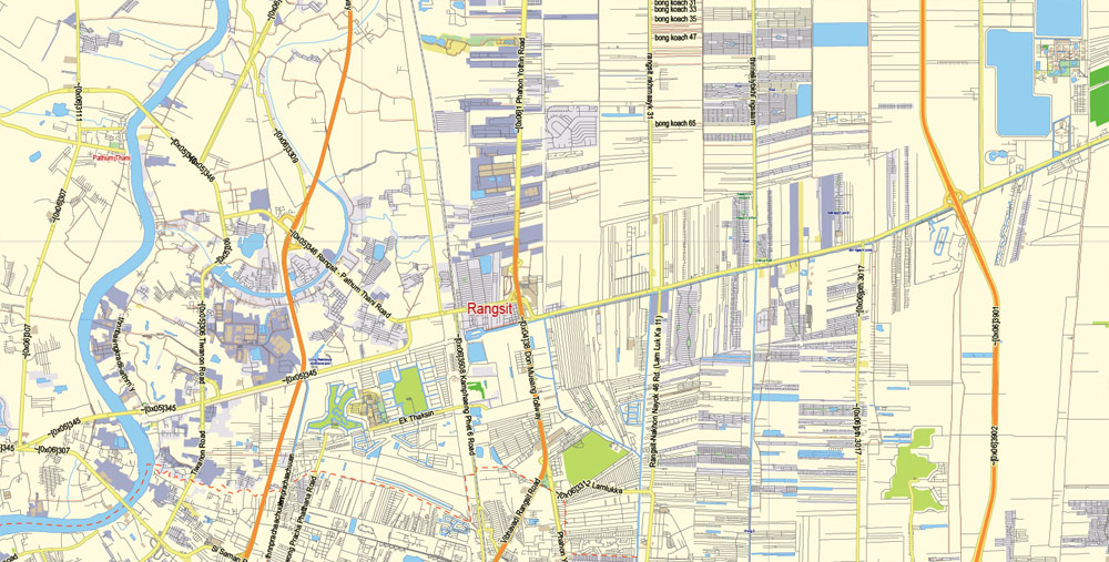
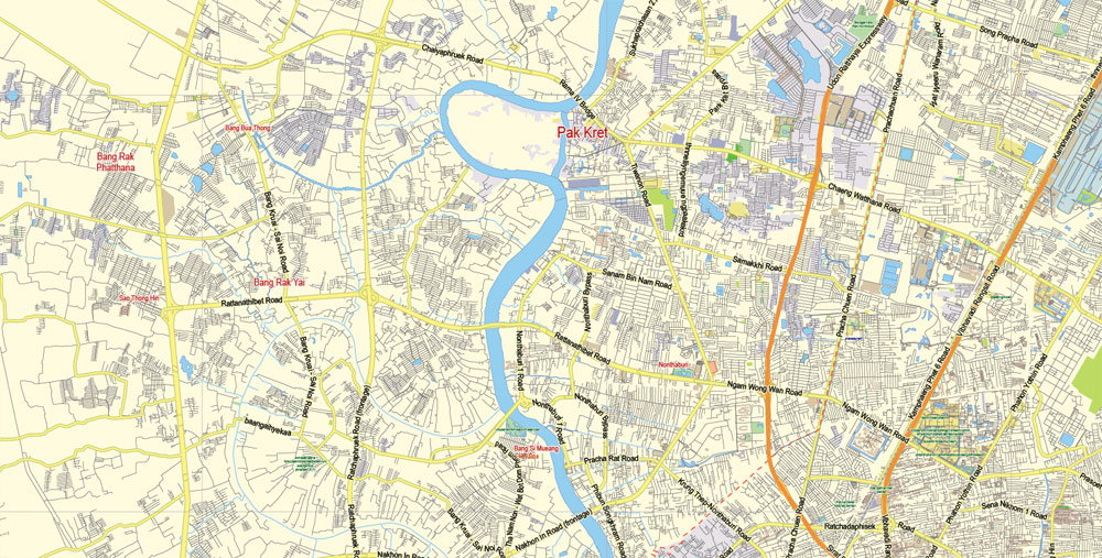
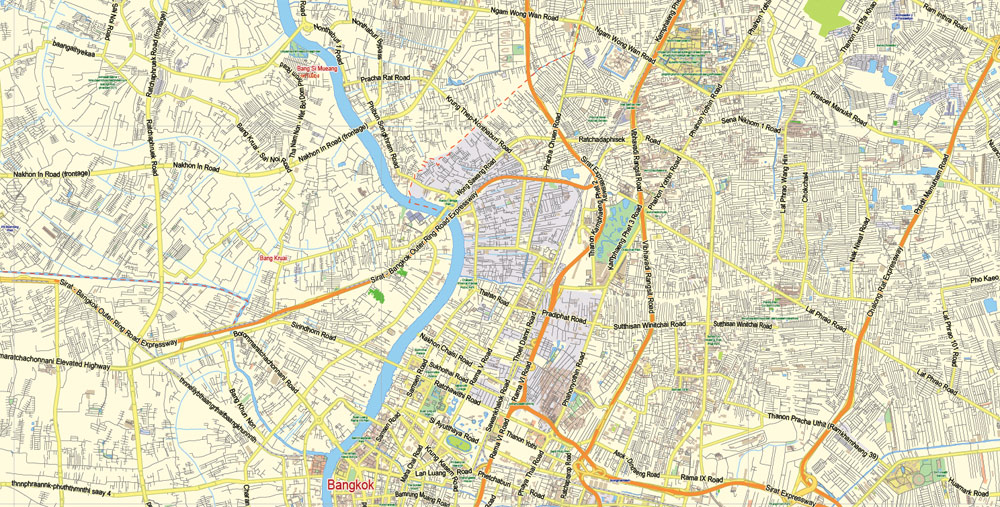
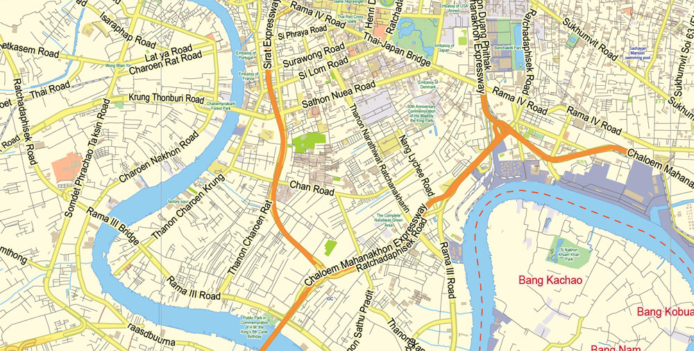
The Bangkok city map in vector format is used for design, urban planning, presentations and media visualizations.
The «Edit color group» button or «Edit or apply color group» on the «Samples» palette.
Click this button if you need to edit the colors in the specific color group or edit and apply them to the selected Vector Map of Bangkok city or a group of its elements, for example, the whole layer “Streets and lines”. You can also double-click the color group in the Samples panel to open the dialog box.
If the map file is too large and your computer freezes or even can’t open it quickly:
1. Try to reduce the color resolution of the video card (display) to 256 colors while working with a large map.
2. Using Windows Task Manager, select all the application you don’t need, while working with map, just turn them off.
3. Launch Adobe Illustrator. (DO NOT OPEN the vector map file)
4. Start the Windows Task Manager using administrator rights > Find the “Illustrator” process > set the «real time» priority,
5. Open the file. When you see the LEGACY FONT popup window – click “OK” (do not update). You can restore the TEXT later.
6. Can also be useful: When file is opened – Edit > Settings > Basic Settings > disable smoothing. /// It looks scary, but works quickly)))
We recommend saving the file in Adobe Illustrator 10 version. It’s much more stable when working with VERY BIG size files.
The city’s urban sprawl reaches into parts of the six other provinces it borders, namely, in clockwise order from northwest: Nonthaburi, Pathum Thani, Chachoengsao, Samut Prakan, Samut Sakhon and Nakhon Pathom. With the exception of Chachoengsao, these provinces, together with Bangkok, form the greater Bangkok Metropolitan Region.
Useful tips on working with vector maps of cities and countries in Adobe Illustrator.
«V» – launches the Selection tool (cursor, black arrow), which makes active any vector line.
«А» – launches the Direct Selection tool (white cursor), allows you to select curve elements and drag them to the desired place.
«R» – activates the Rotate tool, which helps you rotating selected objects around the center point by 360 degrees.
«E» – gives you the opportunity to use the Eraser tool and erase unnecessary parts.
«X» – switches between Fill and Stroke in the Tools section. Try to get used to this hot key and
you will quickly understand that you can’t live and work without it.
Guides are not limited to vertical and horizontal in Adobe Illustrator. You can also create a diagonal guide for example. Moreover, you can turn any contours into guides. Select the outline and go to View > Guides > Make Guides (Create Guides), or simply press Cmd/Ctrl + 5. You can also turn the guides back into an editable object. Go to menu, View > Guides > Unlock Guides (Release Guides), select the guide you want to edit and select View > Guides > Release Guides (Reset Guides), or just press Cmd/Ctrl + Option / Alt + 5).
Topography
Bangkok is in the Chao Phraya River delta in Thailand’s central plains. The river meanders through the city in a southward direction, emptying into the Gulf of Thailand approximately 25 kilometres (16 mi) south of the city centre. The area is flat and low-lying, with an average elevation of 1.5 metres (4 ft 11 in) above sea level. Most of the area was originally swampland, which was gradually drained and irrigated for agriculture via the construction of canals (khlong) which took place throughout the 16th to 19th centuries. The course of the river as it flows through Bangkok has been modified by the construction of several shortcut canals.
Bangkok’s major canals are shown in this map detailing the original course of the river and its shortcut canals.
The undoubted advantage of Bangkok city vector maps in printing is an excellent and detailed visualization, when customer can expand a large paper map and instantly define his location, find a landmark, an object or address on map, unlike using the popular electronic formats of Google and Yandex maps for example.
Printable vector maps of Bangkok city are much more convenient and efficient than any electronic maps on your smartphone, because ALL DETAILS are displayed in the entire space of Bangkok city map.
This intricate waterway network served as the primary mode of transport up until the late 19th century, when modern roads began to be built. Up until then, most people lived near or on the water, leading the city to be known during the 19th century as the “Venice of the East”.

The assign color ability is provided only if the entire map, layer or fragment is selected in the document. You can specify which of new colors replace the current colors, whether the spot colors should be preserved and how colors are replaced (for example, you can replace colors completely or changing the color tone while maintaining the brightness). The «Assign» tab allows you to redefine colors in the Vector Map of Bangkok city, or in separate layers and fragments using the current color group or reducing the number of colors in the current Vector Map.
Color groups
Is a list of all saved color groups for current document (the same groups appear in the «Samples» palette). You can edit and delete the existing color groups, as well as creating a new ones using the list of “Color Groups” in the dialog box. All changes appear in the «Samples» palette.
The highlighted color group shows, which color group is currently edited.
Many of these canals have since been filled in or paved over, but others still criss-cross the city, serving as major drainage channels and transport routes. Most canals are now badly polluted, although the BMA has committed to the treatment and cleaning up of several canals.
The geology of the Bangkok area is characterized by a top layer of soft marine clay known as Bangkok clay, averaging 15 metres (49 ft) in thickness, which overlies an aquifer system consisting of eight known units. This feature has contributed to the effects of subsidence caused by extensive ground water pumping. First recognized in the 1970s, subsidence soon became a critical issue, reaching a rate of 120 millimetres (4.7 in) per year in 1981.
You will probably want to change the color scheme used on our Bangkok vector city map.
To quickly and effectively play with colors.
Of course, you can do it manually, all objects in our Bangkok city vector map are divided according to types and layers, and you can easily change the color gamma of vector objects in groups and layers.
This vector map of Bangkok city is used by: designers, layout designers, printers, advertisers and architects. Our product – vector maps – is designed for further editing and printing in large formats – from @Wall format (a few meters) to A-0 and A-1, A-2, A-3.
Ground water management and mitigation measures have since lessened the severity of the situation, although subsidence is still occurring at a rate of 10 to 30 millimetres (0.39 to 1.18 in) per year, and parts of the city are now 1 metre (3 ft 3 in) below sea level. There are fears that the city may be submerged by 2030.
This is the most detailed, exact map of Bangkok city for high-quality printing and polygraphy. You can always clarify the map development date by contacting us.
Subsidence has resulted in increased flood risk, as Bangkok is already prone to flooding due to its low elevation and inadequate drainage infrastructure resulting from rapid urbanization.
The main areas of the dialog box are:
«Edit»
The «Edit» tab is designed to create a new or edit the existing color groups.
The harmony rules Menu and the Color Wheel are used to conduct experiments with color harmonies. The color wheel shows how colors are related in color harmony, and the color bars allow you to view and manipulate an individual color values. In addition, you can adjust the brightness, add and remove colors, save color groups and view colors on the selected Vector Map of Bangkok city or a separated layers.
Assign
The «Assign» tab is used to view and control on how the original colors are replaced with colors from the color group like your corporate colors in the Vector Map of Bangkok city.
The city now relies on flood barriers and augmenting drainage from canals by pumping and building drain tunnels, but parts of Bangkok and its suburbs are still regularly affected by flooding. Heavy downpours resulting in urban runoff overwhelming drainage systems, and runoff discharge from upstream areas, are major triggering factors.
The advertising and presentation map of Bangkok city (usually the final designer marks the routes, and puts the client’s objects (shops, saloons, gas stations etc.)
The undoubted advantage is that people will NEVER throw out this advertising product – the map. In fact, as an advertising medium, a city map is the most “long-playing” of the well-known polygraphic advertising media, with the longest lifespan, and the maximum number of interactions with the customer.
Severe flooding affecting much of the city occurred recently in 1995 and 2011. In the latter, most of Bangkok’s northern, eastern and western districts became inundated, in some places for over two months. Coastal erosion is also an issue in the gulf coastal area, a small length of which lies within Bangkok’s Bang Khun Thian District.
It’s very easy to work with vector maps of Bangkok city, even for a not very experienced designer who can turn on and off the map layers, add new objects, change the colors of fill and lines according to customer requirements.
Global warming poses further serious risks, and a study by the OECD has estimated that 5.138 million people in Bangkok may be exposed to coastal flooding by 2070, the seventh highest among the world’s port cities.
This vector map of Bangkok city is used as a basis for design, editing, and further printing.
There are no mountains in Bangkok, the closest mountain range being the Khao Khiao Massif, located about 40 km (25 mi) southeast of the city. Phu Khao Thong, the only hill in the metropolitan area, originated in a very large chedi that King Rama III (1787–1851) decided to build at Wat Saket.
One of the advantages of Bangkok city vector maps of our production is the relevance of cartographic data, we constantly update all our products.
The chedi collapsed during construction because the soft soil of Bangkok could not support the weight. Over the next few decades, the abandoned mud-and-brick structure acquired the shape of a natural hill and became overgrown with weeds. The locals called it “phu khao” (ภูเขา), as if it were a natural feature. In the 1940s surrounding concrete walls were added to stop the hill from eroding.
Bangkok
Capital of Thailand
Bangkok, Thailand’s capital, is a large city known for ornate shrines and vibrant street life. The boat-filled Chao Phraya River feeds its network of canals, flowing past the Rattanakosin royal district, home to opulent Grand Palace and its sacred Wat Phra Kaew Temple. Nearby is Wat Pho Temple with an enormous reclining Buddha and, on the opposite shore, Wat Arun Temple with its steep steps and Khmer-style spire.
Area
• City 1,568.737 km2 (605.693 sq mi)
• Metro 7,761.6 km2 (2,996.8 sq mi)
Elevation 1.5 m (4.9 ft)
Population
• City 8,280,925
• Density 5,300/km2 (14,000/sq mi)
• Metro 14,626,225
• Metro density 1,900/km2 (4,900/sq mi)
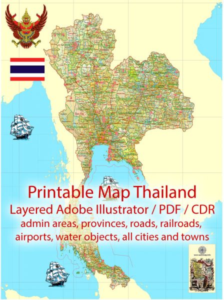
Free vector map World, Adobe Illustrator, download now maps vector clipart
Map for design, projects, presentation free to use as you like.
See also: TERMS & CONDITIONS: SOFTWARE LICENSE AGREEMENT FOR DIGITAL CARTOGRAPHIC DATA.
Need more USA Vector Maps, printable and editable?

 Author: Kirill Shrayber, Ph.D. FRGS