About this vectorial map of France (Europe) in Adobe Illustrator (AI) format
Archive size: 6.44 Mb, zipped .AI
DPI: 300
License: Royalty Free
France maps in Adobe Illustrator format [.AI] are fully editable and scalable maps, it can be printed in all sizes needed, no matter what big it is with no quality loss.
All maps in VectorMap portal have a Royalty Free license. You don`t need to pay for each use and can change all the content you want, including line thickness, font design, or add the objects you want.
We provide very precise vector maps of France, perfect for large size printing, like office walls or bigboards.
Also available in other formats at the same price: DWG, DXF AutoCAD, Corel Draw, EPS, PDF.
This France vector map features:
Highways,
National Park Borders,
Big and small Rivers, small streams also,
Lake, ponds and other water bodies,
Landmark fill.
Need more data, or something special? Please, feel free to contact our friendly team.
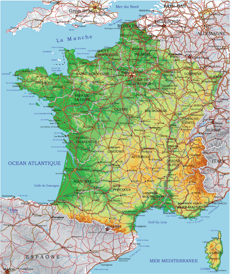
France.
This vector map of France is used as a basis for design, editing, and further printing.
This is the most detailed, exact map of France for high-quality printing and polygraphy. You can always clarify the map development date by contacting us.
For your convenience, all objects on France vector map are divided into layers. And the editing is very easy – colors, lines, etc.
You can easily add any objects needed (e.g. shops, salons, sale points, gas station or attraction) on any layer of France vector map.
France is a country whose territory consists of metropolitan France in Western Europe and several overseas regions and territories. The metropolitan area of France extends from the Mediterranean Sea to the English Channel and the North Sea, and from the Rhine to the Atlantic Ocean. It is bordered by Belgium, Luxembourg and Germany to the northeast, Switzerland and Italy to the east, and Andorra and Spain to the south.
One of the advantages of France vector maps of our production is the relevance of cartographic data, we constantly update all our products.
This vector map of France is used by:
designers, layout designers, printers, advertisers and architects. Our product – vector maps – is designed for further editing and printing in large formats – from @Wall format (a few meters) to A-0 and A-1, A-2, A-3.
The France map in vector format is used for design, urban planning, presentations and media visualizations.
The advertising and presentation map of France (usually the final designer marks the routes, and puts the client’s objects (shops, saloons, gas stations etc.)
The undoubted advantage is that people will NEVER throw out this advertising product – the map. In fact, as an advertising medium, a map is the most “long-playing” of the well-known polygraphic advertising media, with the longest lifespan, and the maximum number of interactions with the customer.
For travelers, maps are sold at the airports and gas stations around the world. Often the source is our vector maps.
Take a look, who purchases our vector maps of France in “Our Clients and Friends” page – these are large and small companies, from super-brands like Volvo and Starbucks, to small design studios and printing houses.
It’s very easy to work with vector maps of France city, even for a not very experienced designer who can turn on and off the map layers, add new objects, change the colors of fill and lines according to customer requirements.
The undoubted advantage of France vector maps in printing is an excellent and detailed visualization, when customer can expand a large paper map and instantly define his location, find a landmark, an object or address on map, unlike using the popular electronic formats of Google and Yandex maps for example.
Printable vector maps of France are much more convenient and efficient than any electronic maps on your smartphone, because ALL DETAILS are displayed in the entire space of France map.
Useful tips on working with vector maps of cities and countries in Adobe Illustrator.
«V» – launches the Selection tool (cursor, black arrow), which makes active any vector line.
«А» – launches the Direct Selection tool (white cursor), allows you to select curve elements and drag them to the desired place.
«R» – activates the Rotate tool, which helps you rotating selected objects around the center point by 360 degrees.
«E» – gives you the opportunity to use the Eraser tool and erase unnecessary parts.
«X» – switches between Fill and Stroke in the Tools section. Try to get used to this hot key and
you will quickly understand that you can’t live and work without it.
Guides are not limited to vertical and horizontal in Adobe Illustrator. You can also create a diagonal guide for example. Moreover, you can turn any contours into guides. Select the outline and go to View > Guides > Make Guides (Create Guides), or simply press Cmd/Ctrl + 5. You can also turn the guides back into an editable object. Go to menu, View > Guides > Unlock Guides (Release Guides), select the guide you want to edit and select View > Guides > Release Guides (Reset Guides), or just press Cmd/Ctrl + Option / Alt + 5).
You will probably want to change the color scheme used on our France vector map.
To quickly and effectively play with colors.
Of course, you can do it manually, all objects in our France vector map are divided according to types and layers, and you can easily change the color gamma of vector objects in groups and layers.
But there is more effective way of working with the whole VECTOR MAP of France and all layers:
The overview dialog «Edit colors»/«Repaint Graphic Object» (this dialog box name can change depending on the context):
If you have selected a part or a layer of France vector map and open the dialog box by clicking the icon in the Control panel, on the Samples palette or the Color Catalog, or if you choose Edit > Edit Colors> Repaint Graphic Object, then the «Repaint Graphic Object» dialog box appears, and you get access to «Assign» and «Edit» tabs.
If a picture or a map fragment is not selected, and you open the dialog box by clicking the icon in the Control panel, on the Samples palette or in the Color Catalog, the «Edit Colors» dialog box appears and you can only access the «Edit» tab.
Regardless of the name at the top of the dialog box, the right-hand side always displays the color group of the current document, as well as two default color groups: Print Color and Grayscale. These color groups can be selected and used any time.
Create and edit color groups of France vector map, and also assign colors using the «Edit Colors»/ а «Repaint Graphic Object» dialog box.
A. Creating and editing of a color group on the «Edit» tab
B. Assigning colors on the «Assign» tab
C. Select a group of colors from the «Color groups» list
The option «Repaint a graphic object» in the lower part of the dialog box allows you to preview the colors on a selected layer of Vector map, or a group of elements, and specify whether its colors will be redefined when the dialog box is closed.
The main areas of the dialog box are:
«Edit»
The «Edit» tab is designed to create a new or edit the existing color groups.
The harmony rules Menu and the Color Wheel are used to conduct experiments with color harmonies. The color wheel shows how colors are related in color harmony, and the color bars allow you to view and manipulate an individual color values. In addition, you can adjust the brightness, add and remove colors, save color groups and view colors on the selected Vector Map of France or a separated layers.
«Assign»
The «Assign» tab is used to view and control on how the original colors are replaced with colors from the color group like your corporate colors in the Vector Map of France city.
The assign color ability is provided only if the entire map, layer or fragment is selected in the document. You can specify which of new colors replace the current colors, whether the spot colors should be preserved and how colors are replaced (for example, you can replace colors completely or changing the color tone while maintaining the brightness). The «Assign» tab allows you to redefine colors in the Vector Map of France city, or in separate layers and fragments using the current color group or reducing the number of colors in the current Vector Map.
Color groups
Is a list of all saved color groups for current document (the same groups appear in the «Samples» palette). You can edit and delete the existing color groups, as well as creating a new ones using the list of “Color Groups” in the dialog box. All changes appear in the «Samples» palette.
The highlighted color group shows, which color group is currently edited.
Any color group can be selected and edited, or used to redefine the colors in the selected vector map of France city, its fragments or elements.
Saving a color group adds this group to the specified list.
Opening the «Edit Colors»/«Repaint Graphic Object» dialog box.
Open the «Edit Colors»/«Repaint Graphic Object» dialog box using one of the following methods:
«Edit»> «Edit Colors»> «Repaint Graphic object» or «Repaint With Style».
Use these commands if you need to edit the colors in the selected vector map of France city.
«Repaint Graphic object» button on the «Control» panel.
Use this button if you need to adjust colors of France vector map using the а «Repaint graphic object» dialog box.
The specified button is available if the selected vector map or its fragment contains two or more colors.
Note. This color editing method is convenient for global color adjustment in a vector map, if global colors were not used when creating a Map of France.
The «Edit colors» button or «Edit or apply colors» on the «Color Catalog» palette
Click this button if you need to edit colors on the «Color Catalog» palette or edit and then apply them to the selected Vector Map of France or its fragment.
The «Edit color group» button or «Edit or apply color group» on the «Samples» palette.
Click this button if you need to edit the colors in the specific color group or edit and apply them to the selected Vector Map of France or a group of its elements, for example, the whole layer “Streets and lines”. You can also double-click the color group in the Samples panel to open the dialog box.
If the map file is too large and your computer freezes or even can’t open it quickly:
1. Try to reduce the color resolution of the video card (display) to 256 colors while working with a large map.
2. Using Windows Task Manager, select all the application you don’t need, while working with map, just turn them off.
3. Launch Adobe Illustrator. (DO NOT OPEN the vector map file)
4. Start the Windows Task Manager using administrator rights > Find the “Illustrator” process > set the «real time» priority,
5. Open the file. When you see the LEGACY FONT popup window – click “OK” (do not update). You can restore the TEXT later.
6. Can also be useful: When file is opened – Edit > Settings > Basic Settings > disable smoothing. /// It looks scary, but works quickly)))
We recommend saving the file in Adobe Illustrator 10 version. It’s much more stable when working with VERY BIG size files.
The overseas territories include French Guiana in South America and several islands in the Atlantic, Pacific and Indian oceans. The country’s 18 integral regions (five of which are situated overseas) span a combined area of 643,801 square kilometres (248,573 sq mi) and a total population of 67.3 million (as of October 2018). France, a sovereign state, is a unitary semi-presidential republic with its capital in Paris, the country’s largest city and main cultural and commercial centre. Other major urban areas include Lyon, Marseille, Toulouse, Bordeaux, Lille and Nice.
During the Iron Age, what is now metropolitan France was inhabited by the Gauls, a Celtic people. Rome annexed the area in 51 BC, holding it until the arrival of Germanic Franks in 476, who formed the Kingdom of France. France emerged as a major European power in the Late Middle Ages following its victory in the Hundred Years’ War (1337 to 1453). During the Renaissance, French culture flourished and a global colonial empire was established, which by the 20th century would become the second largest in the world. The 16th century was dominated by religious civil wars between Catholics and Protestants (Huguenots). France became Europe’s dominant cultural, political, and military power in the 17th century under Louis XIV. In the late 18th century, the French Revolution overthrew the absolute monarchy, established one of modern history’s earliest republics, and saw the drafting of the Declaration of the Rights of Man and of the Citizen, which expresses the nation’s ideals to this day.
In the 19th century, Napoleon took power and established the First French Empire. His subsequent Napoleonic Wars shaped the course of continental Europe. Following the collapse of the Empire, France endured a tumultuous succession of governments culminating with the establishment of the French Third Republic in 1870. France was a major participant in World War I, from which it emerged victorious, and was one of the Allies in World War II, but came under occupation by the Axis powers in 1940. Following liberation in 1944, a Fourth Republic was established and later dissolved in the course of the Algerian War. The Fifth Republic, led by Charles de Gaulle, was formed in 1958 and remains today. Algeria and nearly all the other colonies became independent in the 1960s and typically retained close economic and military connections with France.
France has long been a global centre of art, science, and philosophy. It hosts the world’s fourth-largest number of UNESCO World Heritage Sites and is the leading tourist destination, receiving around 83 million foreign visitors annually. France is a developed country with the world’s seventh-largest economy by nominal GDP, and tenth-largest by purchasing power parity. In terms of aggregate household wealth, it ranks fourth in the world. France performs well in international rankings of education, health care, life expectancy, and human development. France is considered a great power in global affairs, being one of the five permanent members of the United Nations Security Council with the power to veto and an official nuclear-weapon state. It is a leading member state of the European Union and the Eurozone, and a member of the Group of 7, North Atlantic Treaty Organization (NATO), Organisation for Economic Co-operation and Development (OECD), the World Trade Organization (WTO), and La Francophonie.
Geography
The vast majority of France’s territory and population is situated in Western Europe and is called Metropolitan France, to distinguish it from the country’s various overseas polities. It is bordered by the North Sea in the north, the English Channel in the northwest, the Atlantic Ocean in the west and the Mediterranean sea in the southeast. It land borders consist of Belgium and Luxembourg in the northeast, Germany and Switzerland in the east, Italy and Monaco in the southeast, and Andorra and Spain in the south and southwest. With the exception of the northeast, most of France’s land borders are roughly delineated by natural boundaries and geographic features: to the south and southeast, the Pyrenees and the Alps and the Jura, respectively, and to the east, the Rhine river. Due to its shape, France is often referred to as l’Hexagone (“The Hexagon”). Metropolitan France includes various coastal islands, of which the largest is Corsica. Metropolitan France is situated mostly between latitudes 41° and 51° N, and longitudes 6° W and 10° E, on the western edge of Europe, and thus lies within the northern temperate zone. Its continental part covers about 1000 km from north to south and from east to west.
France has several overseas regions across the world, which are organised along different :
In South America: French Guiana.
In the Atlantic Ocean: Saint Pierre and Miquelon and, in the Antilles: Guadeloupe, Martinique, Saint Martin and Saint Barthélemy.
In the Pacific Ocean: French Polynesia, the special collectivity of New Caledonia, Wallis and Futuna and Clipperton Island.
In the Indian Ocean: Réunion island, Mayotte, Kerguelen Islands, Crozet Islands, St. Paul and Amsterdam islands, and the Scattered Islands in the Indian Ocean
In the Antarctic: Adélie Land.
France has land borders with Brazil and Suriname via French Guiana and with the Kingdom of the Netherlands through the French portion of Saint Martin.
Metropolitan France covers 551,500 square kilometres (212,935 sq mi), the largest among European Union members. France’s total land area, with its overseas departments and territories (excluding Adélie Land), is 643,801 km2 (248,573 sq mi), 0.45% of the total land area on Earth. France possesses a wide variety of landscapes, from coastal plains in the north and west to mountain ranges of the Alps in the southeast, the Massif Central in the south central and Pyrenees in the southwest.
Due to its numerous overseas departments and territories scattered across the planet, France possesses the second-largest Exclusive economic zone (EEZ) in the world, covering 11,035,000 km2 (4,260,000 mi2), just behind the EEZ of the United States (11,351,000 km2 or 4,383,000 mi2), but ahead of the EEZ of Australia (8,148,250 km2 / 4,111,312 mi2). Its EEZ covers approximately 8% of the total surface of all the EEZs of the world.
Geology, topography and hydrography
Metropolitan France has a wide variety of topographical sets and natural landscapes. Large parts of the current territory of France were raised during several tectonic episodes like the Hercynian uplift in the Paleozoic Era, during which the Armorican Massif, the Massif Central, the Morvan, the Vosges and Ardennes ranges and the island of Corsica were formed. These massifs delineate several sedimentary basins such as the Aquitaine basin in the southwest and the Paris basin in the north, the latter including several areas of particularly fertile ground such as the silt beds of Beauce and Brie. Various routes of natural passage, such as the Rhône valley, allow easy communications. The Alpine, Pyrenean and Jura mountains are much younger and have less eroded forms. At 4,810.45 metres (15,782 ft)[91] above sea level, Mont Blanc, located in the Alps on the French and Italian border, is the highest point in Western Europe.
Although 60% of municipalities are classified as having seismic risks, these risks remain moderate. The coastlines offer contrasting landscapes: mountain ranges along the French Riviera, coastal cliffs such as the Côte d’Albâtre, and wide sandy plains in the Languedoc. Corsica lies off the Mediterranean coast. France has an extensive river system consisting of the four major rivers Seine, the Loire, the Garonne, the Rhône and their tributaries, whose combined catchment includes over 62% of the metropolitan territory. The Rhône divides the Massif Central from the Alps and flows into the Mediterranean Sea at the Camargue. Other water courses drain towards the Meuse and Rhine along the north-eastern borders. France has 11 million square kilometres (4.2×10⁶ sq mi) of marine waters within three oceans under its jurisdiction, of which 97% are overseas.
Cities and counties near France city vectorial map, Europe
Our vector map of France includes maps of the nearest areas (see the preview):
Toulouse, Auch, Carcassonne, Montpellier, Marseille, Nice, Toulon, Frejus, Aix-en-Provence, Albi, Pau, Montauban, Angouleme, Limoges, Clermont-Ferrand, Saint-Etienne, Lyon, Valence, Paris, Caen, Le Havre, Reims, Metz, Nancy, Orleans, Le Mans, Nantes, Bourges, Amiens, Calais.
Purchasing and downloading of Illustrator France vector map
We accept PayPal and Credit Card. After the payment you will be redirected to the download page. We guarantee 100% satisfaction. Royalty Free license.
VectorMap. Providing high quality vector maps. Enjoy!

 Author: Kirill Shrayber, Ph.D. FRGS


