Extended Description of the Vector Map
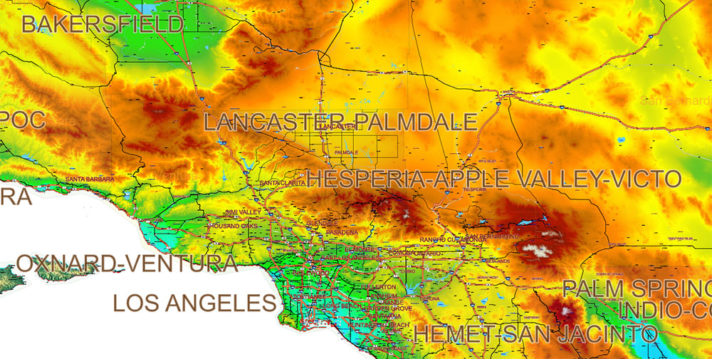
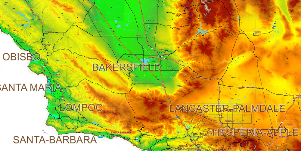
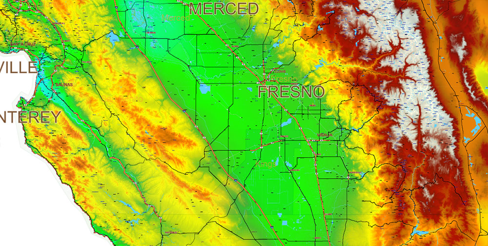
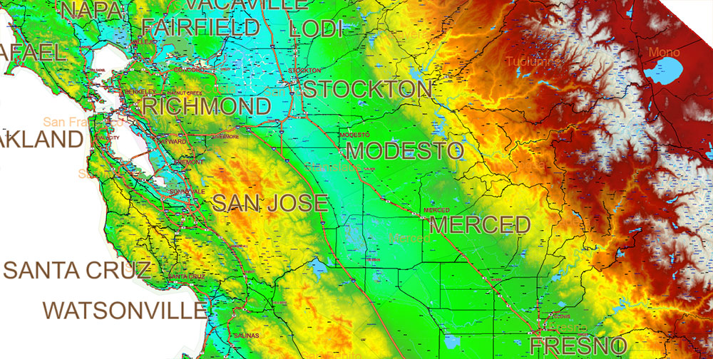
Printable PDF Colored Relief V.3 Vector Map California State (Full Area), US detailed fully editable Adobe PDF Road Map in layers, scalable, text/curves format all names, 444 MB ZIP
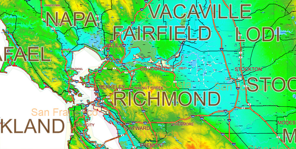
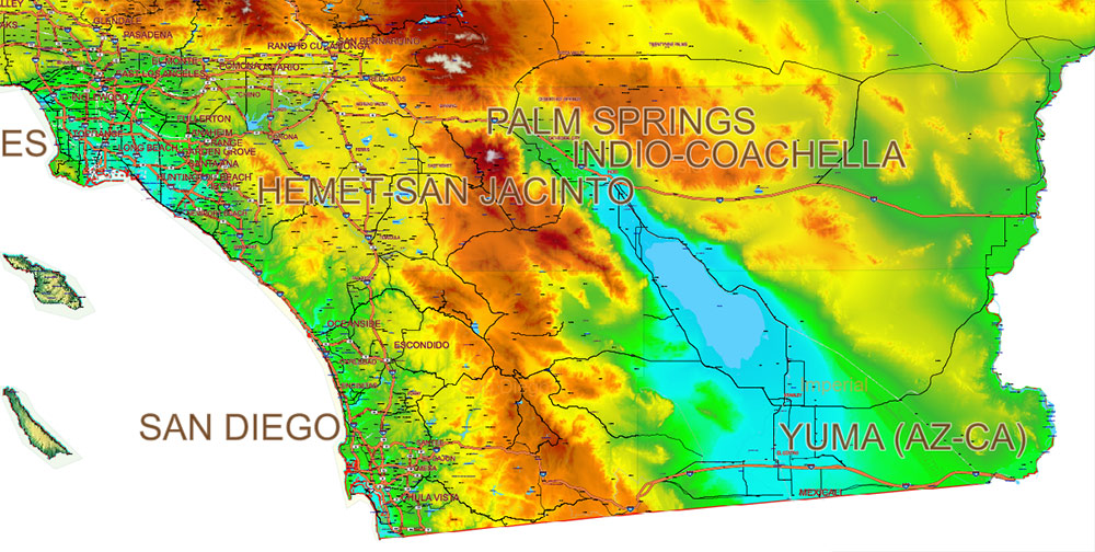
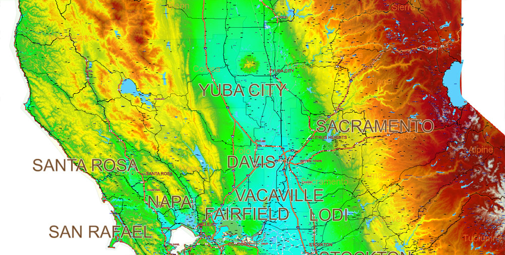
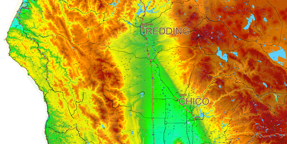
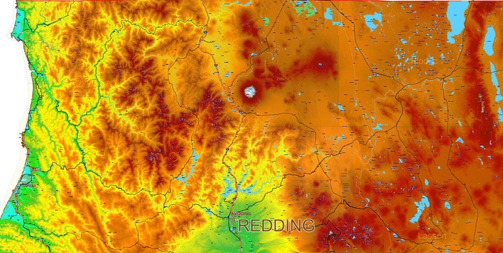
Main streets and roads, Cities and Towns, Water Objects, Railroads, Airports, Relief raster, for Print Size 4 ft.. Map for design, printing, arts, projects, presentations, for architects, designers, and builders, business, logistics.
Note: 2 complete road lines, 2 complete places names, road shields.
Also: We can add (additional layer for this map), any other objects for you. It’s free for our customers.
If you need any OTHER format – DWG, DXF, Corel, or something else – please, email us
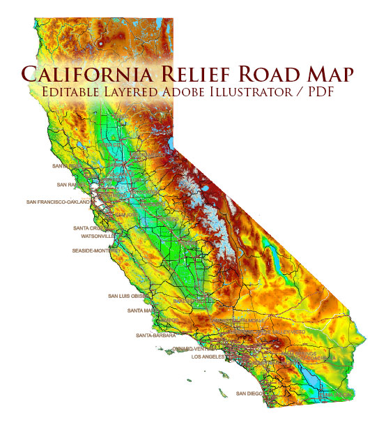
California State US PDF Map Vector Exact High Detailed Roads Map V.3 + Colored Relief editable Adobe PDF in layers
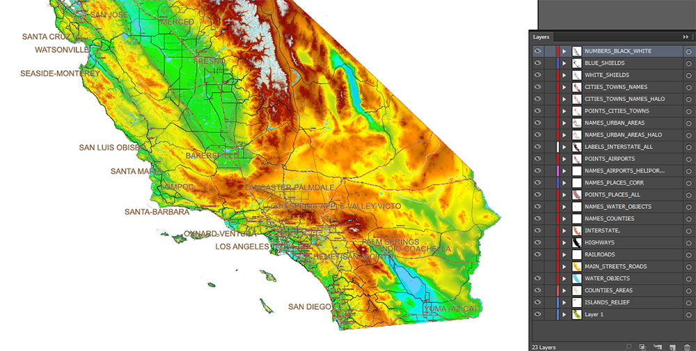
Layers list: (see preview)
- Names of Airports
- Points of Airports
- Names of places (city, hamlet, etc.) 1,2
- Points of places 1, 2
- Names of urban areas
- Names Highways
- Road labels (shields)
- Main streets and roads 1,2
- Railroads
- Water objects (areas)
- Counties areas
- Colored Relief Topo V.3 raster JPG image
AO BRIEF — CALIFORNIA (STATEWIDE)
Color Relief • No Shading • Print & Wall Art Focus
Operational Overview
Statewide color relief vector map of California without shaded terrain. Clean elevation-based color layers emphasize landform structure while preserving graphic clarity. Designed for large-format printing and wall display where aesthetics, readability, and balance are critical.
Relief Representation
-
Elevation expressed through calibrated color bands rather than shadows
-
Smooth, noise-free relief suitable for interiors and decorative use
-
Clear differentiation of coastal plains, valleys, mountain systems, and plateaus
-
No directional lighting — neutral, timeless appearance independent of viewing angle
Visual Balance & Composition
-
Even tonal distribution across the state, avoiding over-contrast
-
Terrain colors support legibility of roads, cities, and water features
-
Optimized for visual harmony at large print sizes
Human & Cultural Layering
-
Cities and towns precisely positioned and clearly labeled
-
Settlement patterns readable without visual competition from terrain shading
-
Suitable for educational, cultural, and residential environments
Transport & Structure
-
Major roads and railways integrated as compositional elements
-
Infrastructure enhances geographic context without overpowering the artwork
-
Ideal for office, studio, and public-space wall maps
Hydrography
-
Rivers, lakes, reservoirs, and coastline rendered cleanly against color relief
-
Water features act as visual anchors within the composition
-
Balanced contrast for print clarity
Print Engineering
-
Fully editable vector PDF with layered structure
-
All labels in text/curves format — print-safe and scalable
-
Designed for large-format wall prints up to 4 ft
-
Suitable for fine art prints, framed maps, and interior design projects
Aesthetic Intent
-
Modern cartographic artwork with restrained technical precision
-
Designed to function equally as a geographic reference and visual object
-
Timeless color-based relief suitable for long-term display
Command Takeaways
-
Color relief without shading for clean, decorative presentation
-
High legibility at large scales
-
Balanced between cartographic accuracy and wall-art aesthetics
-
Ready for print studios, galleries, offices, and private interiors
California State US PDF Map Vector Exact High Detailed Roads Map V.3 + Colored Relief editable Adobe PDF in layers
California State US PDF Map Vector Exact High Detailed Roads Map V.3 + Colored Relief editable Adobe PDF in layers
California State US PDF Map Vector Exact High Detailed Roads Map V.3 + Colored Relief editable Adobe PDF in layers
California State US PDF Map Vector Exact High Detailed Roads Map V.3 + Colored Relief editable Adobe PDF in layers
California State US PDF Map Vector Exact High Detailed Roads Map V.3 + Colored Relief editable Adobe PDF in layers
California State US PDF Map Vector Exact High Detailed Roads Map V.3 + Colored Relief editable Adobe PDF in layers
California State US PDF Map Vector Exact High Detailed Roads Map V.3 + Colored Relief editable Adobe PDF in layers
California State US PDF Map Vector Exact High Detailed Roads Map V.3 + Colored Relief editable Adobe PDF in layers
California State US PDF Map Vector Exact High Detailed Roads Map V.3 + Colored Relief editable Adobe PDF in layers
California State US PDF Map Vector Exact High Detailed Roads Map V.3 + Colored Relief editable Adobe PDF in layers

 Author: Kirill Shrayber, Ph.D. FRGS
")

 editable Adobe Illustrator in layers")