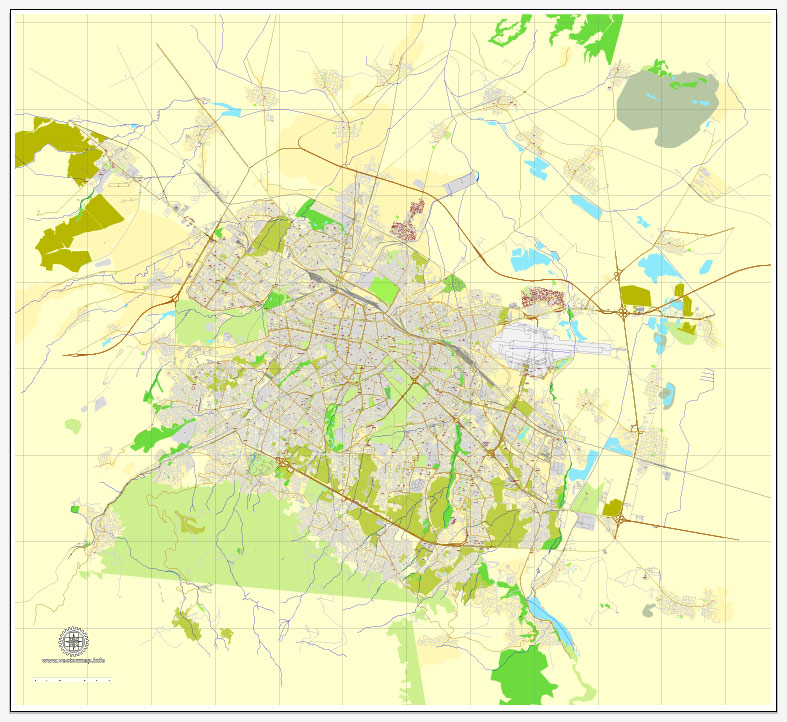
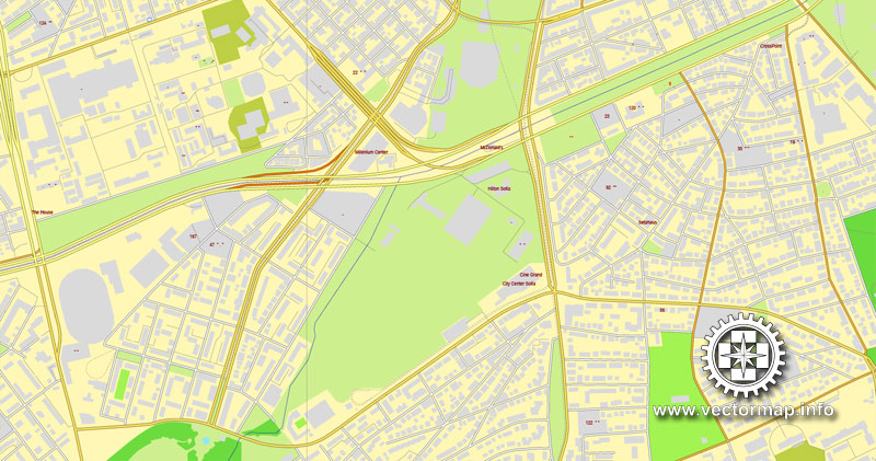
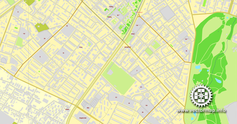
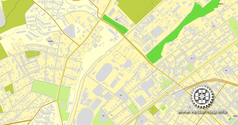
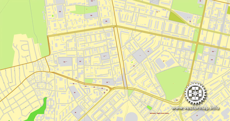
Sofia, Bulgaria, printable vector street map, City Plan, full editable, Adobe Illustrator, Royalty free, full vector, scalable, editable, 7,6 mb ZIP
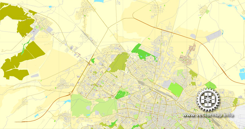
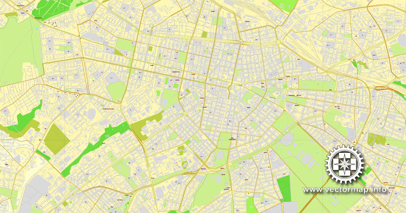
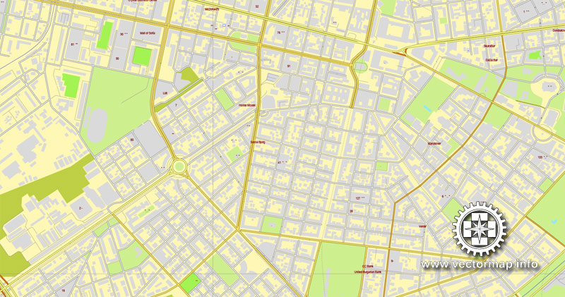
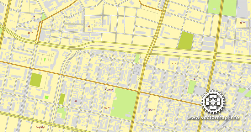
All streets, All buildings.
Attn! No corr street names!
Map for design, print, arts, projects, presentations, for architects, designers and builders.
DXF, DWG, CDR and other formats – on request, same price, please, contact
Sofia, Bulgaria.
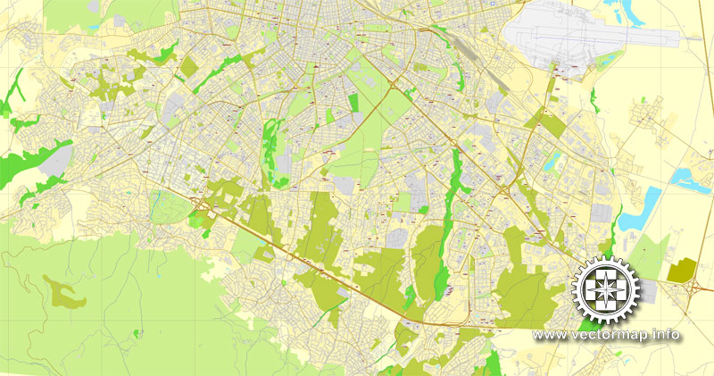
This vector map of Sofia is used as a basis for design, editing, and further printing.
This is the most detailed, exact map of Sofia for high-quality printing and polygraphy. You can always clarify the map development date by contacting us.
For your convenience, all objects on Sofia vector map are divided into layers. And the editing is very easy – colors, lines, etc.
You can easily add any objects needed (e.g. shops, salons, sale points, gas station or attraction) on any layer of Sofia vector map.
Sofia is the capital and largest city of Bulgaria. The city is at the foot of Vitosha Mountain in the western part of the country. Being in the centre of the Balkan peninsula, it is midway between the Black Sea and the Adriatic Sea, and closest to the Aegean Sea.
One of the advantages of Sofia vector maps of our production is the relevance of cartographic data, we constantly update all our products.
This vector map of Sofia is used by:
designers, layout designers, printers, advertisers and architects. Our product – vector maps – is designed for further editing and printing in large formats – from @Wall format (a few meters) to A-0 and A-1, A-2, A-3.
Sofia map in vector format is used for design, urban planning, presentations and media visualizations.
Advertising and presentation map of Sofia (usually the final designer marks the routes, and puts the client’s objects (shops, saloons, gas stations etc.)
The undoubted advantage is that people will NEVER throw out this advertising product – the map. In fact, as an advertising medium, a map is the most “long-playing” of the well-known polygraphic advertising media, with the longest lifespan, and the maximum number of interactions with the customer.
For travelers, maps are sold at the airports and gas stations around the world. Often the source is our vector maps.
Take a look, who purchases our vector maps of Sofia in “Our Clients and Friends” page – these are large and small companies, from super-brands like Volvo and Starbucks, to small design studios and printing houses.
It’s very easy to work with vector maps of Sofia, even for a not very experienced designer who can turn on and off the map layers, add new objects, change the colors of fill and lines according to customer requirements.
The undoubted advantage of Sofia vector maps in printing is an excellent and detailed visualization, when customer can expand a large paper map and instantly define his location, find a landmark, an object or address on map, unlike using the popular electronic formats of Google and Yandex maps for example.
Printable vector maps of Sofia are much more convenient and efficient than any electronic maps on your smartphone, because ALL DETAILS are displayed in the entire space of Sofia map.
Useful tips on working with vector maps of cities and countries in Adobe Illustrator.
«V» – launches the Selection tool (cursor, black arrow), which makes active any vector line.
«А» – launches the Direct Selection tool (white cursor), allows you to select curve elements and drag them to the desired place.
«R» – activates the Rotate tool, which helps you rotating selected objects around the center point by 360 degrees.
«E» – gives you the opportunity to use the Eraser tool and erase unnecessary parts.
«X» – switches between Fill and Stroke in the Tools section. Try to get used to this hot key and
you will quickly understand that you can’t live and work without it.
Guides are not limited to vertical and horizontal in Adobe Illustrator. You can also create a diagonal guide for example. Moreover, you can turn any contours into guides. Select the outline and go to View > Guides > Make Guides (Create Guides), or simply press Cmd/Ctrl + 5. You can also turn the guides back into an editable object. Go to menu, View > Guides > Unlock Guides (Release Guides), select the guide you want to edit and select View > Guides > Release Guides (Reset Guides), or just press Cmd/Ctrl + Option / Alt + 5).
You will probably want to change the color scheme used on our Sofia vector map.
To quickly and effectively play with colors.
Of course, you can do it manually, all objects in our Sofia vector map are divided according to types and layers, and you can easily change the color gamma of vector objects in groups and layers.
But there is more effective way of working with the whole VECTOR MAP of Sofia and all layers:
The overview dialog «Edit colors»/«Repaint Graphic Object» (this dialog box name can change depending on the context):
If you have selected a part or a layer of Sofia vector map and open the dialog box by clicking the icon in the Control panel, on the Samples palette or the Color Catalog, or if you choose Edit > Edit Colors> Repaint Graphic Object, then the «Repaint Graphic Object» dialog box appears, and you get access to «Assign» and «Edit» tabs.
If a picture or a map fragment is not selected, and you open the dialog box by clicking the icon in the Control panel, on the Samples palette or in the Color Catalog, the «Edit Colors» dialog box appears and you can only access the «Edit» tab.
Regardless of the name at the top of the dialog box, the right-hand side always displays the color group of the current document, as well as two default color groups: Print Color and Grayscale. These color groups can be selected and used any time.
Create and edit color groups of Sofia vector map, and also assign colors using the «Edit Colors»/ а «Repaint Graphic Object» dialog box.
A. Creating and editing of a color group on the «Edit» tab
B. Assigning colors on the «Assign» tab
C. Select a group of colors from the «Color groups» list
The option «Repaint a graphic object» in the lower part of the dialog box allows you to preview the colors on a selected layer of Vector map, or a group of elements, and specify whether its colors will be redefined when the dialog box is closed.
The main areas of the dialog box are:
«Edit»
The «Edit» tab is designed to create a new or edit the existing color groups.
The harmony rules Menu and the Color Wheel are used to conduct experiments with color harmonies. The color wheel shows how colors are related in color harmony, and the color bars allow you to view and manipulate an individual color values. In addition, you can adjust the brightness, add and remove colors, save color groups and view colors on the selected Vector Map of Sofia or a separated layers.
«Assign»
The «Assign» tab is used to view and control on how the original colors are replaced with colors from the color group like your corporate colors in the Vector Map of Sofia.
The assign color ability is provided only if the entire map, layer or fragment is selected in the document. You can specify which of new colors replace the current colors, whether the spot colors should be preserved and how colors are replaced (for example, you can replace colors completely or changing the color tone while maintaining the brightness). The «Assign» tab allows you to redefine colors in the Vector Map of Sofia, or in separate layers and fragments using the current color group or reducing the number of colors in the current Vector Map.
Color groups
Is a list of all saved color groups for current document (the same groups appear in the «Samples» palette). You can edit and delete the existing color groups, as well as creating a new ones using the list of “Color Groups” in the dialog box. All changes appear in the «Samples» palette.
The highlighted color group shows, which color group is currently edited.
Any color group can be selected and edited, or used to redefine the colors in the selected vector map of Sofia , its fragments or elements.
Saving a color group adds this group to the specified list.
Opening the «Edit Colors»/«Repaint Graphic Object» dialog box.
Open the «Edit Colors»/«Repaint Graphic Object» dialog box using one of the following methods:
«Edit»> «Edit Colors»> «Repaint Graphic object» or «Repaint With Style».
Use these commands if you need to edit the colors in the selected vector map of Sofia city.
«Repaint Graphic object» button on the «Control» panel.
Use this button if you need to adjust colors of Sofia vector map using the а «Repaint graphic object» dialog box.
The specified button is available if the selected vector map or its fragment contains two or more colors.
Note. This color editing method is convenient for global color adjustment in a vector map, if global colors were not used when creating a Map of Sofia.
The «Edit colors» button or «Edit or apply colors» on the «Color Catalog» palette
Click this button if you need to edit colors on the «Color Catalog» palette or edit and then apply them to the selected Vector Map of Sofia or its fragment.
The «Edit color group» button or «Edit or apply color group» on the «Samples» palette.
Click this button if you need to edit the colors in the specific color group or edit and apply them to the selected Vector Map of Sofia or a group of its elements, for example, the whole layer “Streets and lines”. You can also double-click the color group in the Samples panel to open the dialog box.
If the map file is too large and your computer freezes or even can’t open it quickly:
1. Try to reduce the color resolution of the video card (display) to 256 colors while working with a large map.
2. Using Windows Task Manager, select all the application you don’t need, while working with map, just turn them off.
3. Launch Adobe Illustrator. (DO NOT OPEN the vector map file)
4. Start the Windows Task Manager using administrator rights > Find the “Illustrator” process > set the «real time» priority,
5. Open the file. When you see the LEGACY FONT popup window – click “OK” (do not update). You can restore the TEXT later.
6. Can also be useful: When file is opened – Edit > Settings > Basic Settings > disable smoothing. /// It looks scary, but works quickly)))
We recommend saving the file in Adobe Illustrator 10 version. It’s much more stable when working with VERY BIG size files.
Sofia has been an area of human habitation since at least 7000 BC. The recorded history of Sofia begins with the attestation of the conquest of Serdica by the Roman Republic in 29 BC from the Celtic tribe Serdi, raided by Huns in 343-347 AD and 447 AD, conquered by Visigoths in 376-382 AD, conquered by Avars and Slavs in 617 AD, and on 9th April, 809 Serdica was surrendered to Krum of Bulgaria. Bulgarian rule lasted until 1018, in 1040 and 1193-1382, which was interrupted by more than a century of Byzantine rule and by nearly five centuries-long Ottoman rule until Bulgarian rule was restored in 1878. During World War II Sofia was bombarded by the UK and US Air Forces and at the end of the war, it was seized by the Soviet Army.
Being Bulgaria’s primate city, Sofia is a hometown of many of the major local universities, cultural institutions and commercial companies. Sofia is one of the top 10 best places for start-up business in the world, especially in information technologies. Sofia was Europe’s most affordable capital to visit in 2013.
The population of Sofia declined down from 70,000 in the late 18th century, through 19,000 in 1870, to 11,649 in 1878 and began increasing. Sofia hosts some 1.23 million residents within a territory of 492 km2, a concentration of 17.5% of the country population within the 200th percentile of the country territory. The urban area of Sofia hosts some 1.54 million residents within 5723 km², which comprises Sofia City Province and parts of Sofia Province (Dragoman, Slivnitsa, Kostinbrod, Bozhurishte, Svoge, Elin Pelin, Gorna Malina, Ihtiman, Kostenets) and Pernik Province (Pernik, Radomir), representing 5.16% of the country territory. The metropolitan area of Sofia is based upon one hour of car travel time, stretches internationally and includes Dimitrovgrad in Serbia. Unlike most European metropolitan areas, it is not to be defined as a substantially functional metropolitan area, but is of the type with “limited variety of functions”. The metropolitan region of Sofia is inhabited by a population of 1.68 million and is made up of the whole provinces Sofia City, Sofia and Pernik, comprising more than 10,000 km².
Sofia City Province has an area of 1344 km2. Sofia’s development as a significant settlement owes much to its central position in the Balkans. It is situated in western Bulgaria, at the northern foot of the Vitosha mountain, in the Sofia Valley that is surrounded by the Balkan mountains to the north. The valley has an average altitude of 550 metres (1,800 ft). Unlike most European capitals, Sofia does not have any large rivers or bridges, but is surrounded by comparatively high mountains on all sides. Three mountain passes lead to the city, which have been key roads since antiquity, Vitosha being the watershed between Black and Aegean Seas. A number of low rivers cross the city, including the Vladayska and the Perlovska. The Iskar River in its upper course flows near eastern Sofia. The city is known for its 49 mineral and thermal springs. Artificial and dam lakes were built in the twentieth century. While the 1818 and 1858 earthquakes were intense and destructive, the 2012 Pernik earthquake occurred west of Sofia with a moment magnitude of 5.6 and a much lower Mercalli intensity of VI (Strong). The 2014 Aegean Sea earthquake was also noticed in the city.
Air pollution is a problem in Sofia due to its location in the Sofia valley, which is surrounded by mountains that reduce the ability of the air to self-clean. The air is polluted mostly by particulate matters and nitrogen oxides. Sofia has the most polluted air of any capital in the EU.
Sofia
Capital of Bulgaria
Sofia is the capital of Bulgaria. It’s in the west of the country, below Vitosha Mountain. The city’s churches and monuments reflect more than 2,000 years of history, including Greek, Roman, Ottoman and Soviet occupation. Medieval Boyana church has 13th-century frescoes. Roman-built, 4th-century Rotonda Sveti Georgi church has medieval and Ottoman decoration dating back to the 10th century.
Area: 492 km²
Population: 1.211 million (2012) UNdata
Number of airports: 1
Sofia is the capital and largest city of Bulgaria. The city has a population of 1.26 million, while over 1.5 million people live in its functional urban area. The city is located at the foot of Vitosha Mountain in the western part of the country, within less than 50 kilometres (31 mi) drive from the Serbian border. Its location in the centre of the Balkan peninsula means that it is the midway between the Black Sea and the Adriatic Sea, whereas the Aegean Sea is the closest to it.
Sofia has been an area of human habitation since at least 7000 BCE. Being Bulgaria’s primate city, Sofia is a hometown of many of the major local universities, cultural institutions and commercial companies. Sofia is one of the top 10 best places for start-up business in the world, especially in IT technologies. Sofia is Europe’s most affordable capital to visit as of 2013.
Sofia has an area of 492 km2, while Sofia City Province has an area of 1344 km2. Sofia’s development as a significant settlement owes much to its central position in the Balkans. It is situated in western Bulgaria, at the northern foot of the Vitosha mountain, in the Sofia Valley that is surrounded by the Balkan mountains to the north. The valley has an average altitude of 550 metres (1,800 ft). Unlike most European capitals, Sofia does not have any large rivers or bridges, but is surrounded by comparatively high mountains on all sides. Three mountain passes lead to the city, which have been key roads since antiquity, Vitosha being the watershed between Black and Aegean Seas. A number of low rivers cross the city, including the Vladayska and the Perlovska. The Iskar River in its upper course flows near eastern Sofia. The city is known for its 49 mineral and thermal springs. Artificial and dam lakes were built in the twentieth century. The 1818 Sofia earthquake was a 6.0–7.2 Medvedev–Sponheuer–Karnik Scale earthquake, the 1858 earthquake was an 6,6 same scale earthquake though reaching up to 10 in parts such as Boyana, this was followed by a 7–8 MSK Sofia earthquake in 1917 and finally by the 2012 Pernik earthquake which was a 5.6 Mw (or 5.8 ML) magnitude earthquake. The 2014 Aegean Sea earthquake was also noticed in the city.
Air pollution is a problem in Sofia due to its location in the Sofia valley, which is surrounded by mountains that reduce the ability of the air to self-clean. The air is polluted mostly by particulate matters and nitrogen oxides. Sofia has the most polluted air of any capital in the EU.
Source Wiki

Free vector map World, Adobe Illustrator, download now maps vector clipart Map for design, projects, presentation free to use as you like. World map vector, Vector world map, World vector map, Map western europe, West europe maps, Map of the world modifiable, High resolution world map, World map illustrator, World map PDF editable, World vector map download,
Free vector map World, Adobe Illustrator, download now maps vector clipart
Map for design, projects, presentation free to use as you like.
Free Download All World Vector Maps here >>>>>
See also: TERMS & CONDITIONS: SOFTWARE LICENSE AGREEMENT FOR DIGITAL CARTOGRAPHIC DATA
Small guide: How to work with the vector map?
You can: Mass select objects by type and color – for example, the objects type “building” (they are usually dark gray) – and remove them from the map, if you do not need them in your print or design project. You can also easily change the thickness of lines (streets), just bulk selection the road by the line color.
The streets are separated by type, for example, type “residential road” are usually white with a gray stroke. Highway usually orange with a brown or dark gray stroke.
All objects are divided by types: different types of roads and streets, polygons of buildings, landfills, urban areas, parks and more other.
It is easy to change the font of inscriptions, all or each individually. Also, just can be make and any other manipulation of objects on the vector map in Adobe illustrator format.
Important: All the proportions on the map are true, that is, the relative sizes of the objects are true, because Map is based on an accurate GPS projection, and It transated into the (usual for all) the Mercator projection.
You can easily change the color, stroke and fill of any object on the map, zoom without loss of quality Image Verification.
Select object

Bulk selection the same objects on the vector map

See the bulk selected objects on the vector map

Bulk delete buildungs from the vector map

Select residencial road (small street) on the vector map

Bulk selection the same lines (streets, roads) on the full map

Create fat lines of the streets on the vector maps (bulk action) 1

Create fat lines of the streets on the vector maps (bulk action) 2

Create fat lines of the streets on the vector maps (bulk action) 3

You can easily change the color, stroke and fill of any object on the map, zoom without loss of quality Image Verification.

 Author: Kirill Shrayber, Ph.D. FRGS

