Luxembourg City, Luxembourg, printable vector street City Plan map, full editable, Adobe Illustrator, full vector, scalable, editable, text format street names, 2,7 mb ZIP
All streets, All buildings. Map for design, print, arts, projects, presentations.
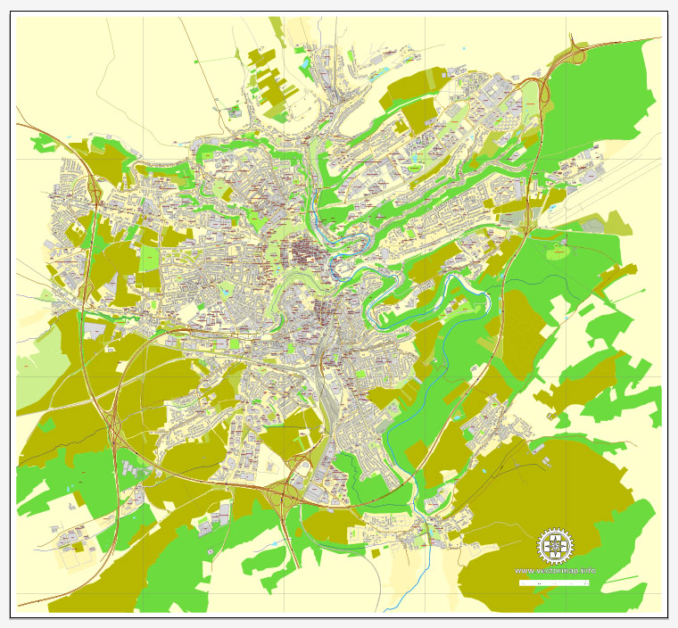
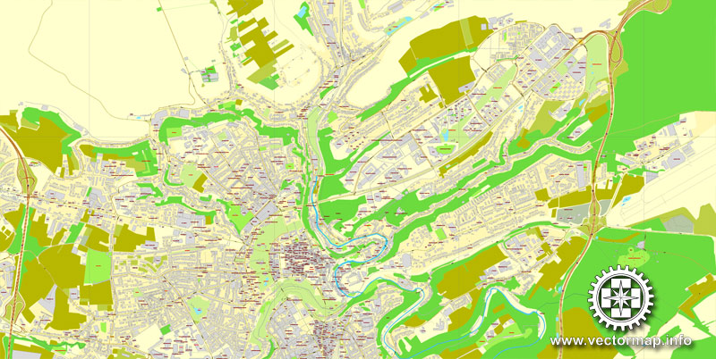
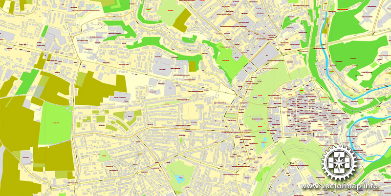
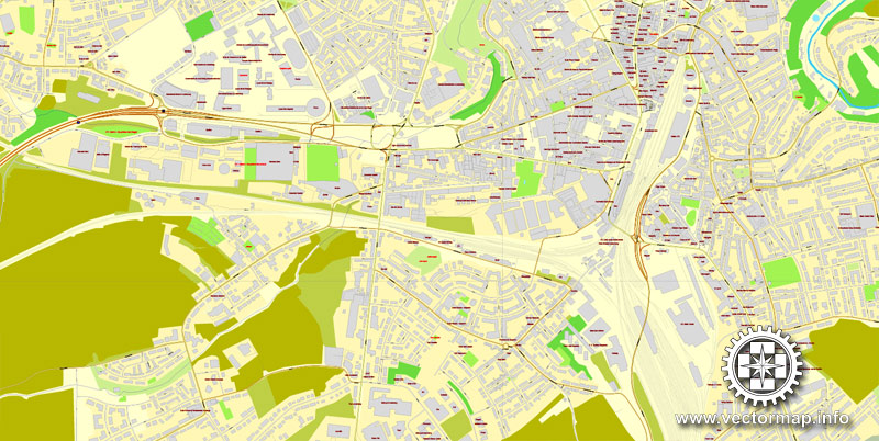
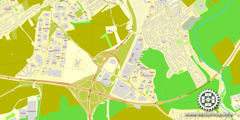
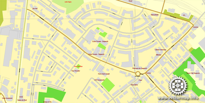
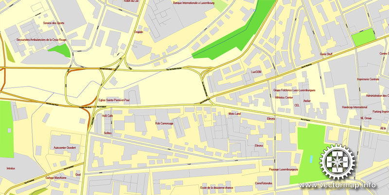
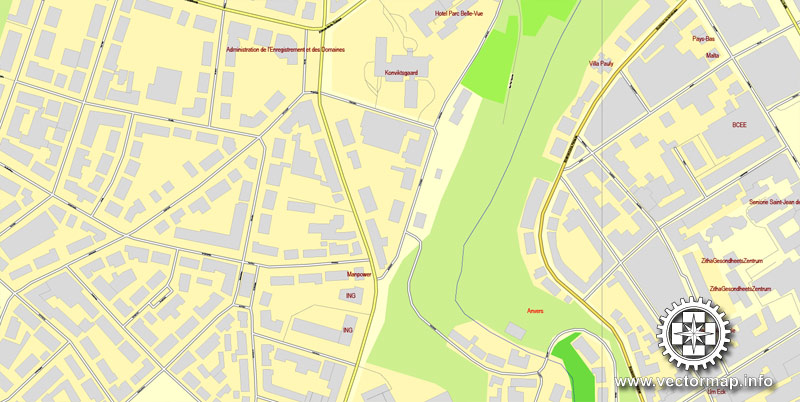
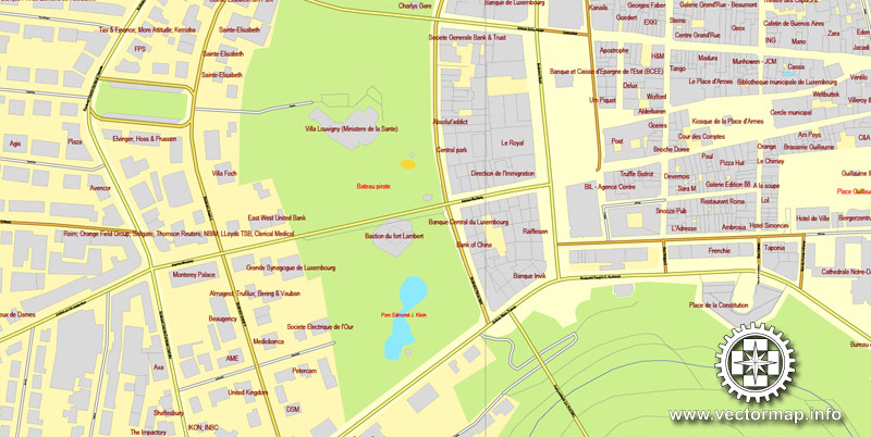
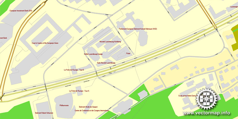
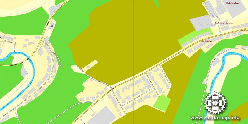
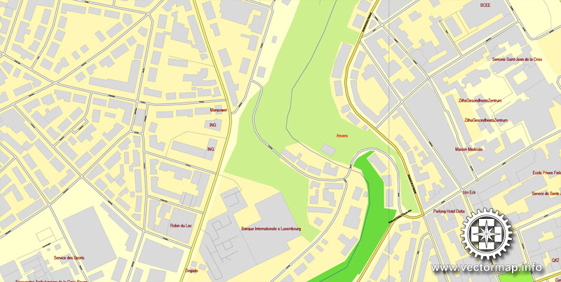
The most accurate and detailed map of the city.
Different font colors of the street names (black); object names by type (brown, red).
DXF, DWG, CDR and other formats – on request, same price, please, contact
Luxembourg.
This vector map of Luxembourg is used as a basis for design, editing, and further printing.
This is the most detailed, exact map of Luxembourg for high-quality printing and polygraphy. You can always clarify the map development date by contacting us.
For your convenience, all objects on Luxembourg vector map are divided into layers. And the editing is very easy – colors, lines, etc.
You can easily add any objects needed (e.g. shops, salons, sale points, gas station or attraction) on any layer of Luxembourg vector map.
Luxembourg is a small landlocked country in western Europe. It is bordered by Belgium to the west and north, Germany to the east, and France to the south. Its capital, Luxembourg City, together with Brussels and Strasbourg, is one of the three official capitals of the European Union and the seat of the European Court of Justice, the highest judicial authority in the EU.
One of the advantages of Luxembourg vector maps of our production is the relevance of cartographic data, we constantly update all our products.
This vector map of Luxembourg is used by:
designers, layout designers, printers, advertisers and architects. Our product – vector maps – is designed for further editing and printing in large formats – from @Wall format (a few meters) to A-0 and A-1, A-2, A-3.
The Luxembourg map in vector format is used for design, urban planning, presentations and media visualizations.
The advertising and presentation map of Luxembourg (usually the final designer marks the routes, and puts the client’s objects (shops, saloons, gas stations etc.)
The undoubted advantage is that people will NEVER throw out this advertising product – the map. In fact, as an advertising medium, a map is the most “long-playing” of the well-known polygraphic advertising media, with the longest lifespan, and the maximum number of interactions with the customer.
For travelers, maps are sold at the airports and gas stations around the world. Often the source is our vector maps.
Take a look, who purchases our vector maps of Luxembourg in “Our Clients and Friends” page – these are large and small companies, from super-brands like Volvo and Starbucks, to small design studios and printing houses.
It’s very easy to work with vector maps of Luxembourg city, even for a not very experienced designer who can turn on and off the map layers, add new objects, change the colors of fill and lines according to customer requirements.
The undoubted advantage of Luxembourg vector maps in printing is an excellent and detailed visualization, when customer can expand a large paper map and instantly define his location, find a landmark, an object or address on map, unlike using the popular electronic formats of Google and Yandex maps for example.
Printable vector maps of Luxembourg are much more convenient and efficient than any electronic maps on your smartphone, because ALL DETAILS are displayed in the entire space of Luxembourg map.
Useful tips on working with vector maps of cities and countries in Adobe Illustrator.
«V» – launches the Selection tool (cursor, black arrow), which makes active any vector line.
«А» – launches the Direct Selection tool (white cursor), allows you to select curve elements and drag them to the desired place.
«R» – activates the Rotate tool, which helps you rotating selected objects around the center point by 360 degrees.
«E» – gives you the opportunity to use the Eraser tool and erase unnecessary parts.
«X» – switches between Fill and Stroke in the Tools section. Try to get used to this hot key and
you will quickly understand that you can’t live and work without it.
Guides are not limited to vertical and horizontal in Adobe Illustrator. You can also create a diagonal guide for example. Moreover, you can turn any contours into guides. Select the outline and go to View > Guides > Make Guides (Create Guides), or simply press Cmd/Ctrl + 5. You can also turn the guides back into an editable object. Go to menu, View > Guides > Unlock Guides (Release Guides), select the guide you want to edit and select View > Guides > Release Guides (Reset Guides), or just press Cmd/Ctrl + Option / Alt + 5).
You will probably want to change the color scheme used on our Luxembourg vector map.
To quickly and effectively play with colors.
Of course, you can do it manually, all objects in our Luxembourg vector map are divided according to types and layers, and you can easily change the color gamma of vector objects in groups and layers.
But there is more effective way of working with the whole VECTOR MAP of Luxembourg and all layers:
The overview dialog «Edit colors»/«Repaint Graphic Object» (this dialog box name can change depending on the context):
If you have selected a part or a layer of Luxembourg vector map and open the dialog box by clicking the icon in the Control panel, on the Samples palette or the Color Catalog, or if you choose Edit > Edit Colors> Repaint Graphic Object, then the «Repaint Graphic Object» dialog box appears, and you get access to «Assign» and «Edit» tabs.
If a picture or a map fragment is not selected, and you open the dialog box by clicking the icon in the Control panel, on the Samples palette or in the Color Catalog, the «Edit Colors» dialog box appears and you can only access the «Edit» tab.
Regardless of the name at the top of the dialog box, the right-hand side always displays the color group of the current document, as well as two default color groups: Print Color and Grayscale. These color groups can be selected and used any time.
Create and edit color groups of Luxembourg vector map, and also assign colors using the «Edit Colors»/ а «Repaint Graphic Object» dialog box.
A. Creating and editing of a color group on the «Edit» tab
B. Assigning colors on the «Assign» tab
C. Select a group of colors from the «Color groups» list
The option «Repaint a graphic object» in the lower part of the dialog box allows you to preview the colors on a selected layer of Vector map, or a group of elements, and specify whether its colors will be redefined when the dialog box is closed.
The main areas of the dialog box are:
«Edit»
The «Edit» tab is designed to create a new or edit the existing color groups.
The harmony rules Menu and the Color Wheel are used to conduct experiments with color harmonies. The color wheel shows how colors are related in color harmony, and the color bars allow you to view and manipulate an individual color values. In addition, you can adjust the brightness, add and remove colors, save color groups and view colors on the selected Vector Map of Luxembourg or a separated layers.
«Assign»
The «Assign» tab is used to view and control on how the original colors are replaced with colors from the color group like your corporate colors in the Vector Map of Luxembourg city.
The assign color ability is provided only if the entire map, layer or fragment is selected in the document. You can specify which of new colors replace the current colors, whether the spot colors should be preserved and how colors are replaced (for example, you can replace colors completely or changing the color tone while maintaining the brightness). The «Assign» tab allows you to redefine colors in the Vector Map of Luxembourg city, or in separate layers and fragments using the current color group or reducing the number of colors in the current Vector Map.
Color groups
Is a list of all saved color groups for current document (the same groups appear in the «Samples» palette). You can edit and delete the existing color groups, as well as creating a new ones using the list of “Color Groups” in the dialog box. All changes appear in the «Samples» palette.
The highlighted color group shows, which color group is currently edited.
Any color group can be selected and edited, or used to redefine the colors in the selected vector map of Luxembourg city, its fragments or elements.
Saving a color group adds this group to the specified list.
Opening the «Edit Colors»/«Repaint Graphic Object» dialog box.
Open the «Edit Colors»/«Repaint Graphic Object» dialog box using one of the following methods:
«Edit»> «Edit Colors»> «Repaint Graphic object» or «Repaint With Style».
Use these commands if you need to edit the colors in the selected vector map of Luxembourg city.
«Repaint Graphic object» button on the «Control» panel.
Use this button if you need to adjust colors of Luxembourg vector map using the а «Repaint graphic object» dialog box.
The specified button is available if the selected vector map or its fragment contains two or more colors.
Note. This color editing method is convenient for global color adjustment in a vector map, if global colors were not used when creating a Map of Luxembourg.
The «Edit colors» button or «Edit or apply colors» on the «Color Catalog» palette
Click this button if you need to edit colors on the «Color Catalog» palette or edit and then apply them to the selected Vector Map of Luxembourg or its fragment.
The «Edit color group» button or «Edit or apply color group» on the «Samples» palette.
Click this button if you need to edit the colors in the specific color group or edit and apply them to the selected Vector Map of Luxembourg or a group of its elements, for example, the whole layer “Streets and lines”. You can also double-click the color group in the Samples panel to open the dialog box.
If the map file is too large and your computer freezes or even can’t open it quickly:
1. Try to reduce the color resolution of the video card (display) to 256 colors while working with a large map.
2. Using Windows Task Manager, select all the application you don’t need, while working with map, just turn them off.
3. Launch Adobe Illustrator. (DO NOT OPEN the vector map file)
4. Start the Windows Task Manager using administrator rights > Find the “Illustrator” process > set the «real time» priority,
5. Open the file. When you see the LEGACY FONT popup window – click “OK” (do not update). You can restore the TEXT later.
6. Can also be useful: When file is opened – Edit > Settings > Basic Settings > disable smoothing. /// It looks scary, but works quickly)))
We recommend saving the file in Adobe Illustrator 10 version. It’s much more stable when working with VERY BIG size files.
Its culture, people, and languages are highly intertwined with its neighbours, making it essentially a mixture of French and German cultures, as evident by the nation’s three official languages: French, German, and the national language, Luxembourgish (sometimes considered a dialect of German). The repeated invasions by Germany, especially in World War II, resulted in the country’s strong will for mediation between France and Germany and, among other things, led to the foundation of the European Union.
With an area of 2,586 square kilometres (998 sq mi), it is one of the smallest sovereign states in Europe. In 2016, Luxembourg had a population of 576,249, which makes it one of the least-populous countries in Europe, but by far the one with the highest population growth rate. Foreigners account for nearly half of Luxembourg’s population. As a representative democracy with a constitutional monarch, it is headed by Grand Duke Henri and is the world’s only remaining grand duchy. Luxembourg is a developed country, with an advanced economy and one of the world’s highest GDP (PPP) per capita. The City of Luxembourg with its old quarters and fortifications was declared a UNESCO World Heritage Site in 1994 due to the exceptional preservation of the vast fortifications and the old city.
The history of Luxembourg is considered to begin in 963, when count Siegfried I acquired a rocky promontory and its Roman-era fortifications known as Lucilinburhuc, ′little castle′, and the surrounding area from the Imperial Abbey of St. Maximin in nearby Trier. Siegfried’s descendants increased their territory through marriage, war and vassal relations. At the end of the 13th century, the Counts of Luxembourg reigned over a considerable territory. In 1308, Henry VII, Count of Luxembourg became King of the Germans and Holy Roman Emperor. The House of Luxembourg produced four Holy Roman Emperors at the high time of the Middle Ages. In 1354, Charles IV elevated the County to the Duchy of Luxembourg. Since Sigismund had no male heir, the Duchy became part of the Burgundian Circle and then one of the Seventeen Provinces of the Habsburg Netherlands. Over the centuries, the City and Fortress of Luxembourg, of great strategic importance situated between the Kingdom of France and the Habsburg territories, was gradually built up to be one of the most reputed fortifications in Europe. After belonging to both the France of Louis XIV and the Austria of Maria Theresia, Luxembourg became part of the First French Republic and Empire under Napoleon.
The present-day state of Luxembourg first emerged at the Congress of Vienna in 1815. The Grand-Duchy, with its powerful fortress, became an independent state under the personal possession of William I of the Netherlands with a Prussian garrison to guard the city against another invasion from France. In 1839, following the turmoil of the Belgian Revolution, the purely Oil-speaking part of Luxembourg was ceded to Belgium and the Luxembourgish-speaking part (except the Arelerland, the area around Arlon) became what is the present state of Luxembourg.
Luxembourg is a founding member of the European Union, OECD, United Nations, NATO, and Benelux. The city of Luxembourg, which is the country’s capital and largest city, is the seat of several institutions and agencies of the EU. Luxembourg served on the United Nations Security Council for the years 2013 and 2014, which was a first in the country’s history. In 2016 Luxembourgish citizens had visa-free or visa-on-arrival access to 172 countries and territories, ranking the Luxembourgish passport 15th in the world, tied with countries such as Canada and Switzerland.


Luxembourg, officially the Grand Duchy of Luxembourg, is a landlocked country in western Europe. It is bordered by Belgium to the west and north, Germany to the east, and France to the south. Its capital Luxembourg City is together with Brussels and Strasbourg one of the three official capitals of the European Union and seat of the European Court of Justice, highest juridical instance in the EU. Its culture, people and languages are highly intertwined with its neighbors, making it essentially a mixture of French and Germanic cultures. The repeated invasions by its neighbor countries, especially in World War II, resulted in the country’s strong will for mediation between France and Germany and led to the foundation of the European Union.
It comprises two principal regions: the Oesling in the north as part of the Ardennes massif, and the Gutland (“Good Land”) in the south. With an area of 2,586 square kilometres (998 sq mi), it is one of the smallest sovereign states in Europe (about the same size as the state of Rhode Island or the English county of Northamptonshire).
Luxembourg had a population of 524,853 in October 2012, ranking it the 8th least-populous country in Europe. As a representative democracy with a constitutional monarch, it is headed by a grand duke, Henri, Grand Duke of Luxembourg, and is the world’s only remaining grand duchy. Luxembourg is a developed country, with an advanced economy and the world’s highest GDP (PPP) per capita, according to the United Nations in 2014. Its central location has historically made it of great strategic importance to numerous powers, dating back to its founding as a Roman fortress, its hosting of a vital Frankish castle during the Early Middle Ages, and its role as a bastion for the Spanish Road between the 16th and 17th centuries.
Luxembourg is a founding member of the European Union, OECD, United Nations, NATO, and Benelux, reflecting its political consensus in favour of economic, political, and military integration. The city of Luxembourg, which is the country’s capital and largest city, is the seat of several institutions and agencies of the EU. Luxembourg served on the United Nations Security Council for the years 2013 and 2014, which was a first in the country’s history. In 2016, Luxembourgish citizens had visa-free or visa-on-arrival access to 172 countries and territories, ranking the Luxembourgian passport 6th in the world, tied with countries such as Canada and Switzerland.
Small guide: How to work with the vector map?
You can: Mass select objects by type and color – for example, the objects type “building” (they are usually dark gray) – and remove them from the map, if you do not need them in your print or design project. You can also easily change the thickness of lines (streets), just bulk selection the road by the line color.
The streets are separated by type, for example, type “residential road” are usually white with a gray stroke. Highway usually orange with a brown or dark gray stroke.
It is easy to change the font of inscriptions, all or each individually. Also, just can be make and any other manipulation of objects on the vector map in Adobe illustrator format.
Important: All the proportions on the map are true, that is, the relative sizes of the objects are true, because Map is based on an accurate GPS projection, and It transated into the (usual for all) the Mercator projection.
You can easily change the color, stroke and fill of any object on the map, zoom without loss of quality Image Verification.
Select object

Bulk selection the same objects on the vector map

See the bulk selected objects on the vector map

Bulk delete buildungs from the vector map

Select residencial road (small street) on the vector map

Bulk selection the same lines (streets, roads) on the full map

Create fat lines of the streets on the vector maps (bulk action) 1

Create fat lines of the streets on the vector maps (bulk action) 2

Create fat lines of the streets on the vector maps (bulk action) 3

You can easily change the color, stroke and fill of any object on the map, zoom without loss of quality Image Verification.


 Author: Kirill Shrayber, Ph.D. FRGS

