Extended Description of the Vector Map
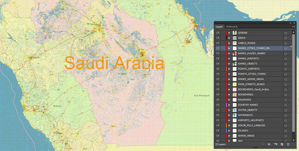
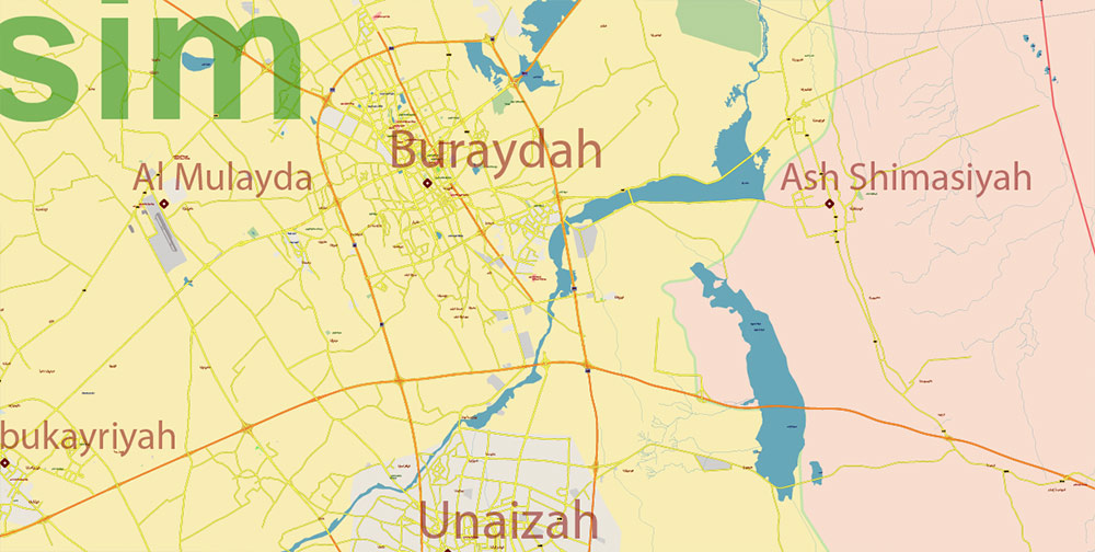
Printable PDF Vector Map of Saudi Arabia high detailed road map + provinces areas + main cities and towns and water objects editable Layered Adobe PDF, scalable, editable text format of all names, 339 Mb ZIP.
Layered exact editable map: Map for publishing, design, printing, publications, arts, projects, presentations, for architects, designers, and builders, business, logistics. The most exact and detailed map. GPS correct Mercator Projection.
For printing Wall extra large format Extra Detailed.
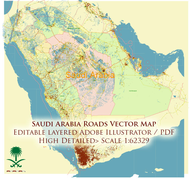
Saudi Arabia HD PDF Vector Map high detailed roads and admin, editable layered in Adobe PDF
Separated layers:
- Legend (scales)
- Grids
- Road labels
- Points main Cities
- Points of the Airports
- Names Cities and Towns (arabic)
- Names Cities (english)
- Names Airports (english)
- Names provinces
- Names Countries
- Names objects (parks, hospitals)
- Country boundaries Saudi Arabia
- Main boundaries
- Names Countries
- Main roads
- Railroads
- Waterways
- Water areas
- Land use areas
- Provinces areas
- Islands
- Sea
- Background
Saudi Arabia HD PDF Vector Map high detailed roads and admin, editable layered in Adobe PDF
Saudi Arabia HD PDF Vector Map high detailed roads and admin, editable layered in Adobe PDF
AO BRIEF: SAUDI ARABIA
(Tactical Overview – Strategic, Geographic, and Human Terrain Summary)
1. OVERVIEW
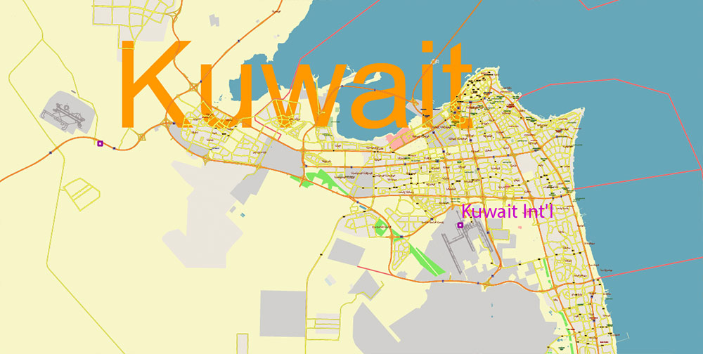
Kingdom of Saudi Arabia (KSA) dominates the central Arabian Peninsula, bordered by Jordan, Iraq, Kuwait, Qatar, the UAE, Oman, and Yemen, with long coastlines on both the Red Sea (west) and Persian Gulf (east). Terrain is mostly arid desert plateau with isolated mountain ranges and scattered oasis settlements. The national core is concentrated in the central and eastern sectors.
2. KEY CITIES / URBAN CENTERS
-
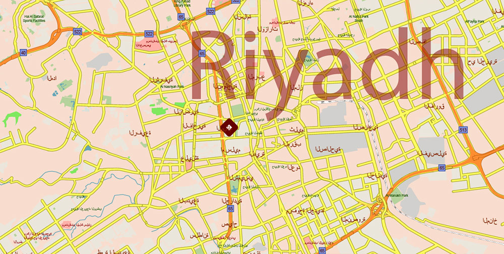
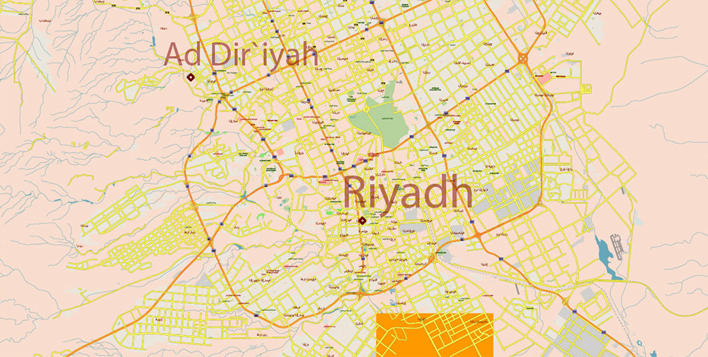
Riyadh – Capital and largest city; administrative, political, and industrial hub. Located in the central Najd plateau. Major transport node connecting east–west and north–south routes.
-
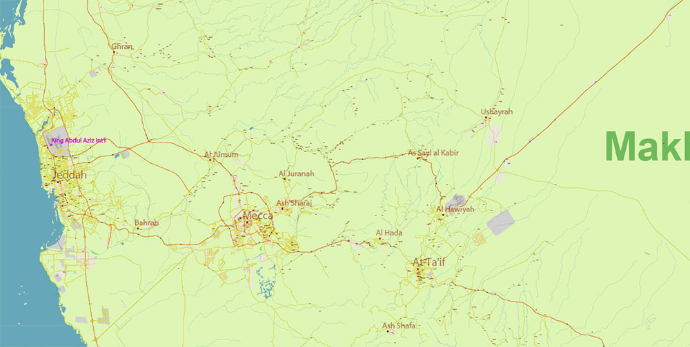
Jeddah – Principal Red Sea port and gateway to Mecca; major commercial and logistics hub.
-
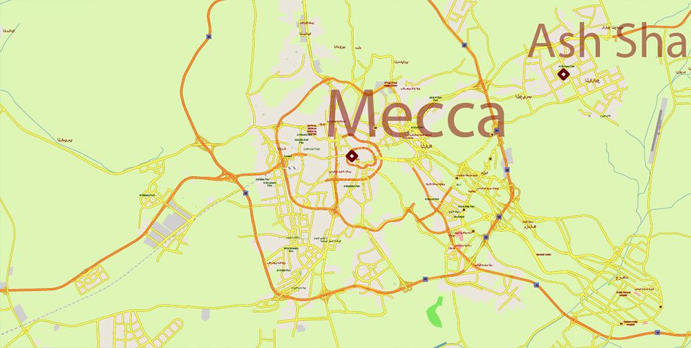
Mecca (Makkah) – Religious capital of Islam, restricted to Muslims; massive seasonal population surges during Hajj and Umrah.
-
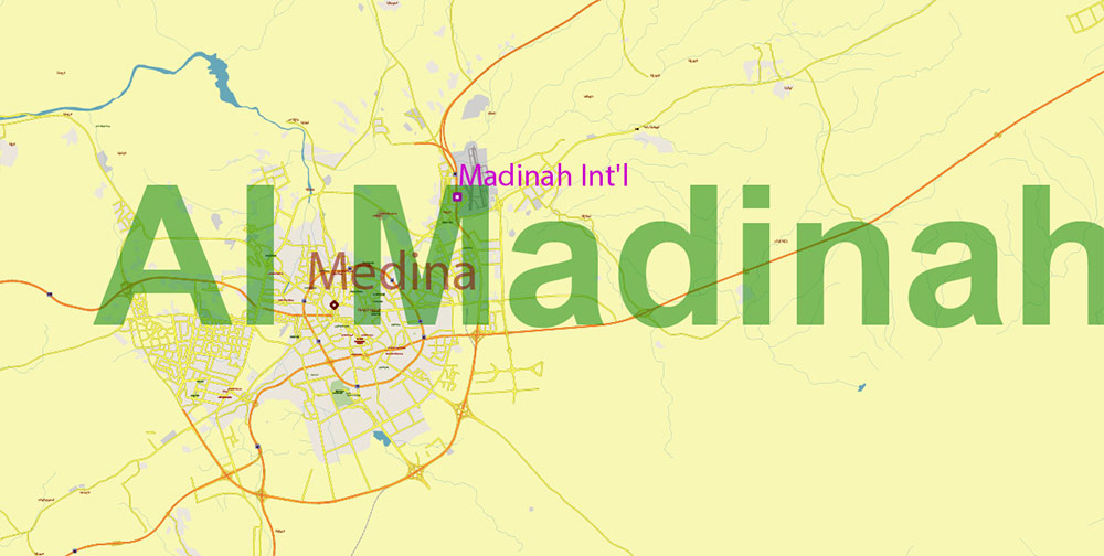
Medina (Al-Madinah) – Second holy city; also in the Hejaz region.
-
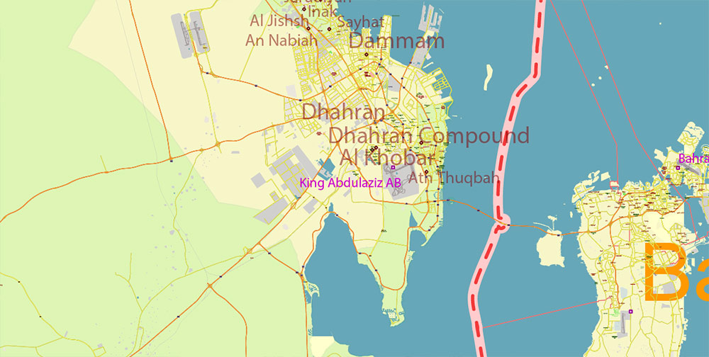
Dammam / Dhahran / Khobar (Eastern Province) – Tri-city industrial and energy complex on the Gulf coast; headquarters of Saudi Aramco.
-
Taif – Hill resort southwest of Riyadh; alternate government retreat, moderate climate.
-
Tabuk, Hail, Abha, Najran – Secondary regional centers; host military, logistical, and agricultural infrastructure.
3. LINES OF COMMUNICATION / ROAD NETWORK
-
Highway 40 (East–West Corridor): Connects Jeddah → Mecca → Riyadh → Dammam; main arterial road across the kingdom (~1,200 km).
-
Highway 15 (North–South Hejaz Route): Runs from Jordanian border through Tabuk → Medina → Mecca → Jazan near Yemen.
-
Highway 65 (Central Spine): From Buraydah/Hail south to Riyadh and north to Qurayyat; key military and internal supply route.
-
Coastal Roads: Red Sea route (Jeddah–Yanbu–Jazan) and Gulf route (Khafji–Jubail–Dammam–Hofuf).
-
Rail:
-
Riyadh–Dammam freight and passenger line (legacy).
-
Haramain High-Speed Railway: Mecca–Jeddah–Medina corridor (high-value civilian transport).
-
North–South Rail (mining corridor, Al-Haditha–Riyadh).
4. GEOGRAPHY / TERRAIN
-
Western Hejaz Mountains: Steep escarpments rising from the Red Sea coastal plain (Tihamah) to 2,500 m; contain Jeddah, Mecca, Medina.
-
Central Najd Plateau: Semi-arid tableland (600–1,000 m), sparse vegetation, numerous wadis; Riyadh located here.
-
Eastern Al-Hasa Region: Flat coastal plain along Persian Gulf, extensive oilfields (Ghawar, Abqaiq).
-
Southern Asir Highlands: Rugged, green mountains bordering Yemen; receives the most rainfall.
-
Empty Quarter (Rub’ al Khali): World’s largest sand desert; largely uninhabited, minimal routes except survey tracks and pipelines.
5. DEMOGRAPHY / HUMAN TERRAIN
-
Population: ~36 million (2025 est.).
-
Ethnic composition: Predominantly Arab (Najdi, Hejazi, Asiri tribes), with ~30% expatriates (South Asian, Filipino, African workers).
-
Religion: Islam 100% (majority Sunni; Shia minority in Eastern Province).
-
Urbanization: >85% urban; main population axes along the Riyadh–Dammam and Jeddah–Mecca–Medina corridors.
-
Labor distribution: oil & gas, construction, logistics, defense, and services.
6. CLIMATE / SEASONALITY
-
Hot desert climate (BWh) – extreme daytime heat, minimal rainfall.
-
Summer (May–Sep): +40–50 °C inland; coastal humidity high.
-
Winter (Dec–Feb): mild (10–25 °C), rare frost in northern plateau.
-
Sandstorms frequent March–May; reduced visibility affects mobility and air ops.
7. LOGISTICS / INFRASTRUCTURE
-
Ports: Jeddah Islamic Port (Red Sea), King Abdulaziz Port (Dammam, Gulf).
-
Airfields: Riyadh (RUH), Jeddah (JED), Dammam (DMM), Medina (MED), Abha (AHB), Tabuk (TUU), Najran (EAM).
-
Pipelines: Criss-cross the eastern region; east–west crude pipeline to Yanbu critical for export resilience.
-
Power & Water: Heavy desalination dependence; vulnerable to disruption at coastal plants.
8. COMMAND TAKEAWAYS
-
Centers of gravity: Riyadh (political), Dammam–Dhahran (energy), Jeddah–Mecca–Medina (religious/ideological).
-
Critical corridors: Highway 40 (E–W logistics spine), pipelines to Yanbu and Dammam.
-
Terrain challenges: Vast distances, limited cover, desert mobility constraints, extreme climate exposure.
-
Human terrain: Highly urbanized, demographically young, with expatriate labor concentration in eastern and western corridors.
Saudi Arabia HD PDF Vector Map high detailed roads and admin, editable layered in Adobe PDF
Saudi Arabia HD PDF Vector Map high detailed roads and admin, editable layered in Adobe PDF

Saudi Arabia HD PDF Vector Map high detailed roads and admin, editable layered in Adobe PDF
Saudi Arabia HD PDF Vector Map high detailed roads and admin, editable layered in Adobe PDF

Saudi Arabia HD PDF Vector Map high detailed roads and admin, editable layered in Adobe PDF
Saudi Arabia HD PDF Vector Map high detailed roads and admin, editable layered in Adobe PDF
Saudi Arabia HD PDF Vector Map high detailed roads and admin, editable layered in Adobe PDF
Saudi Arabia HD PDF Vector Map high detailed roads and admin, editable layered in Adobe PDF
Saudi Arabia HD PDF Vector Map high detailed roads and admin, editable layered in Adobe PDF
Saudi Arabia HD PDF Vector Map high detailed roads and admin, editable layered in Adobe PDF


 Author: Kirill Shrayber, Ph.D. FRGS


