Map Republica Dominicana DXF & DWG for AutoCAD for architects, designers, planners para los arquitectos, diseñadores, planificadores.
Dominican Republic.
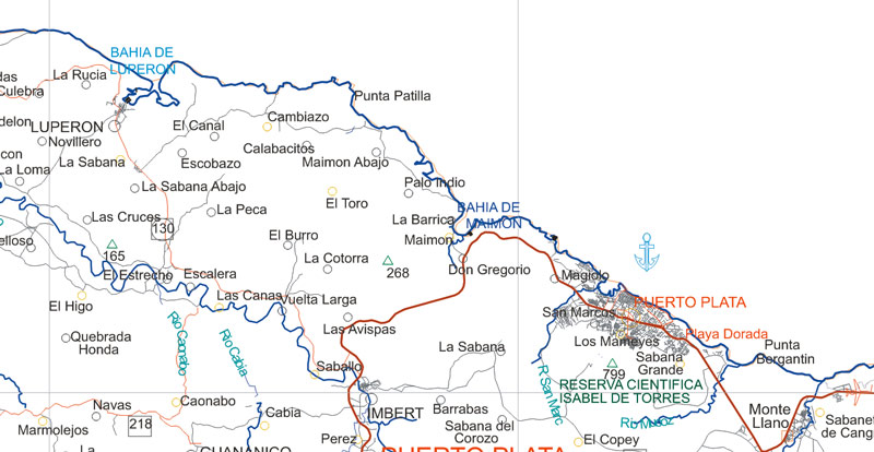
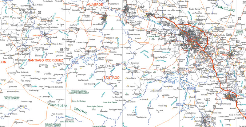
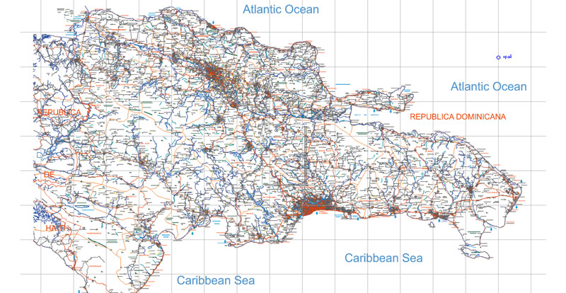
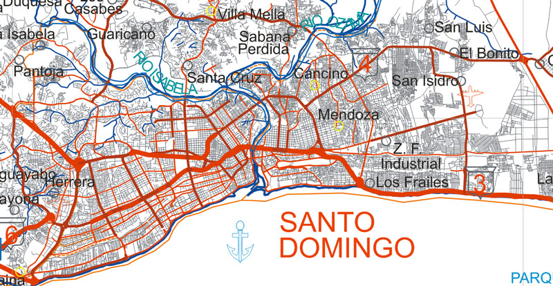
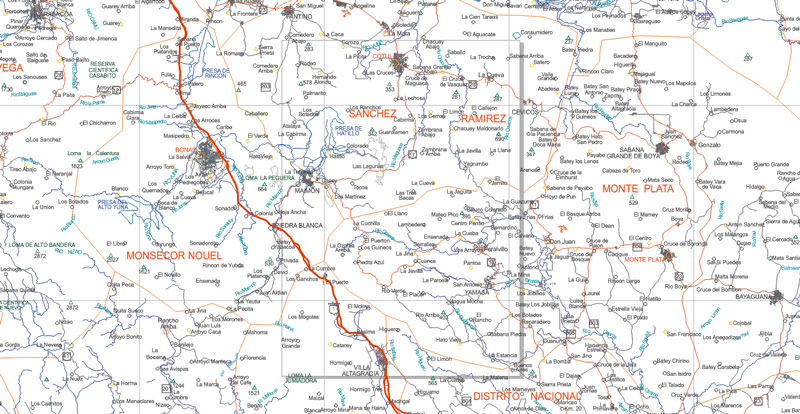
This vector map of Dominican Republic is used as a basis for design, editing, and further printing.
This is the most detailed, exact map of Dominican Republic for high-quality printing and polygraphy. You can always clarify the map development date by contacting us.
For your convenience, all objects on Dominican Republic vector map are divided into layers. And the editing is very easy – colors, lines, etc.
You can easily add any objects needed (e.g. shops, salons, sale points, gas station or attraction) on any layer of Dominican Republic vector map.
The Dominican Republic is a country located in the island of Hispaniola, in the Greater Antilles archipelago of the Caribbean region. It occupies the eastern five-eighths of the island, which it shares with the nation of Haiti, making Hispaniola one of two Caribbean islands, along with Saint Martin, that are shared by two sovereign states. The Dominican Republic is the second-largest Caribbean nation by area (after Cuba) at 48,671 square kilometers (18,792 sq mi), and third by population with approximately 10 million people, of which approximately three million live in the metropolitan area of Santo Domingo, the capital city.
One of the advantages of Dominican Republic vector maps of our production is the relevance of cartographic data, we constantly update all our products.
This vector map of Dominican Republic is used by:
designers, layout designers, printers, advertisers and architects. Our product – vector maps – is designed for further editing and printing in large formats – from @Wall format (a few meters) to A-0 and A-1, A-2, A-3.
Dominican Republic map in vector format is used for design, urban planning, presentations and media visualizations.
Advertising and presentation map of Dominican Republic (usually the final designer marks the routes, and puts the client’s objects (shops, saloons, gas stations etc.)
The undoubted advantage is that people will NEVER throw out this advertising product – the map. In fact, as an advertising medium, a map is the most “long-playing” of the well-known polygraphic advertising media, with the longest lifespan, and the maximum number of interactions with the customer.
For travelers, maps are sold at the airports and gas stations around the world. Often the source is our vector maps.

Take a look, who purchases our vector maps of Dominican Republic in “Our Clients and Friends” page – these are large and small companies, from super-brands like Volvo and Starbucks, to small design studios and printing houses.
It’s very easy to work with vector maps of Dominican Republic, even for a not very experienced designer who can turn on and off the map layers, add new objects, change the colors of fill and lines according to customer requirements.
The undoubted advantage of Dominican Republic vector maps in printing is an excellent and detailed visualization, when customer can expand a large paper map and instantly define his location, find a landmark, an object or address on map, unlike using the popular electronic formats of Google and Yandex maps for example.
Printable vector maps of Dominican Republic are much more convenient and efficient than any electronic maps on your smartphone, because ALL DETAILS are displayed in the entire space of Dominican Republic map.
Useful tips on working with vector maps of cities and countries in Adobe Illustrator.
«V» – launches the Selection tool (cursor, black arrow), which makes active any vector line.
«А» – launches the Direct Selection tool (white cursor), allows you to select curve elements and drag them to the desired place.
«R» – activates the Rotate tool, which helps you rotating selected objects around the center point by 360 degrees.
«E» – gives you the opportunity to use the Eraser tool and erase unnecessary parts.
«X» – switches between Fill and Stroke in the Tools section. Try to get used to this hot key and
you will quickly understand that you can’t live and work without it.
Guides are not limited to vertical and horizontal in Adobe Illustrator. You can also create a diagonal guide for example. Moreover, you can turn any contours into guides. Select the outline and go to View > Guides > Make Guides (Create Guides), or simply press Cmd/Ctrl + 5. You can also turn the guides back into an editable object. Go to menu, View > Guides > Unlock Guides (Release Guides), select the guide you want to edit and select View > Guides > Release Guides (Reset Guides), or just press Cmd/Ctrl + Option / Alt + 5).
You will probably want to change the color scheme used on our Dominican Republic vector map.
To quickly and effectively play with colors.
Of course, you can do it manually, all objects in our Dominican Republic vector map are divided according to types and layers, and you can easily change the color gamma of vector objects in groups and layers.
But there is more effective way of working with the whole VECTOR MAP of Dominican Republic and all layers:
The overview dialog «Edit colors»/«Repaint Graphic Object» (this dialog box name can change depending on the context):
If you have selected a part or a layer of Dominican Republic vector map and open the dialog box by clicking the icon in the Control panel, on the Samples palette or the Color Catalog, or if you choose Edit > Edit Colors> Repaint Graphic Object, then the «Repaint Graphic Object» dialog box appears, and you get access to «Assign» and «Edit» tabs.
If a picture or a map fragment is not selected, and you open the dialog box by clicking the icon in the Control panel, on the Samples palette or in the Color Catalog, the «Edit Colors» dialog box appears and you can only access the «Edit» tab.
Regardless of the name at the top of the dialog box, the right-hand side always displays the color group of the current document, as well as two default color groups: Print Color and Grayscale. These color groups can be selected and used any time.
Create and edit color groups of Dominican Republic vector map, and also assign colors using the «Edit Colors»/ а «Repaint Graphic Object» dialog box.
A. Creating and editing of a color group on the «Edit» tab
B. Assigning colors on the «Assign» tab
C. Select a group of colors from the «Color groups» list
The option «Repaint a graphic object» in the lower part of the dialog box allows you to preview the colors on a selected layer of Vector map, or a group of elements, and specify whether its colors will be redefined when the dialog box is closed.
The main areas of the dialog box are:
«Edit»
The «Edit» tab is designed to create a new or edit the existing color groups.
The harmony rules Menu and the Color Wheel are used to conduct experiments with color harmonies. The color wheel shows how colors are related in color harmony, and the color bars allow you to view and manipulate an individual color values. In addition, you can adjust the brightness, add and remove colors, save color groups and view colors on the selected Vector Map of Dominican Republic or a separated layers.
«Assign»
The «Assign» tab is used to view and control on how the original colors are replaced with colors from the color group like your corporate colors in the Vector Map of Dominican Republic.
The assign color ability is provided only if the entire map, layer or fragment is selected in the document. You can specify which of new colors replace the current colors, whether the spot colors should be preserved and how colors are replaced (for example, you can replace colors completely or changing the color tone while maintaining the brightness). The «Assign» tab allows you to redefine colors in the Vector Map of Dominican Republic, or in separate layers and fragments using the current color group or reducing the number of colors in the current Vector Map.
Color groups
Is a list of all saved color groups for current document (the same groups appear in the «Samples» palette). You can edit and delete the existing color groups, as well as creating a new ones using the list of “Color Groups” in the dialog box. All changes appear in the «Samples» palette.
The highlighted color group shows, which color group is currently edited.
Any color group can be selected and edited, or used to redefine the colors in the selected vector map of Dominican Republic , its fragments or elements.
Saving a color group adds this group to the specified list.
Opening the «Edit Colors»/«Repaint Graphic Object» dialog box.
Open the «Edit Colors»/«Repaint Graphic Object» dialog box using one of the following methods:
«Edit»> «Edit Colors»> «Repaint Graphic object» or «Repaint With Style».
Use these commands if you need to edit the colors in the selected vector map of Dominican Republic city.
«Repaint Graphic object» button on the «Control» panel.
Use this button if you need to adjust colors of Dominican Republic vector map using the а «Repaint graphic object» dialog box.
The specified button is available if the selected vector map or its fragment contains two or more colors.
Note. This color editing method is convenient for global color adjustment in a vector map, if global colors were not used when creating a Map of Dominican Republic.
The «Edit colors» button or «Edit or apply colors» on the «Color Catalog» palette
Click this button if you need to edit colors on the «Color Catalog» palette or edit and then apply them to the selected Vector Map of Dominican Republic or its fragment.
The «Edit color group» button or «Edit or apply color group» on the «Samples» palette.
Click this button if you need to edit the colors in the specific color group or edit and apply them to the selected Vector Map of Dominican Republic or a group of its elements, for example, the whole layer “Streets and lines”. You can also double-click the color group in the Samples panel to open the dialog box.
If the map file is too large and your computer freezes or even can’t open it quickly:
1. Try to reduce the color resolution of the video card (display) to 256 colors while working with a large map.
2. Using Windows Task Manager, select all the application you don’t need, while working with map, just turn them off.
3. Launch Adobe Illustrator. (DO NOT OPEN the vector map file)
4. Start the Windows Task Manager using administrator rights > Find the “Illustrator” process > set the «real time» priority,
5. Open the file. When you see the LEGACY FONT popup window – click “OK” (do not update). You can restore the TEXT later.
6. Can also be useful: When file is opened – Edit > Settings > Basic Settings > disable smoothing. /// It looks scary, but works quickly)))
We recommend saving the file in Adobe Illustrator 10 version. It’s much more stable when working with VERY BIG size files.
Christopher Columbus landed on the island on December 5, 1492, which the native Taíno people had inhabited since the 7th century. The colony of Santo Domingo became the site of the first permanent European settlement in the Americas, the oldest continuously inhabited city, and the first seat of the Spanish colonial rule in the New World. After more than three hundred years of Spanish rule the Dominican people declared independence in November 1821. The leader of the independence movement José Núñez de Cáceres, intended the Dominican nation to unite with the country of Gran Colombia, but no longer under Spain’s custody the newly independent Dominicans were forcefully annexed by Haiti in February 1822. Independence came 22 years later after victory in the Dominican War of Independence in 1844. Over the next 72 years the Dominican Republic experienced mostly internal conflicts and a brief return to colonial status before permanently ousting Spanish rule during the Dominican War of Restoration of 1863–1865. A United States occupation lasted eight years between 1916 and 1924, and a subsequent calm and prosperous six-year period under Horacio Vásquez was followed by the dictatorship of Rafael Leónidas Trujillo until 1961. A civil war in 1965, the country’s last, was ended by U.S. military occupation and was followed by the authoritarian rule of Joaquín Balaguer (1966–1978 & 1986–1996), the rules of Antonio Guzmán (1972–1978) & Salvador Jorge Blanco (1982–1986). Since 1996, the Dominican Republic has moved toward representative democracy and has been led by Leonel Fernández for most of the time since 1996. Danilo Medina, the Dominican Republic’s current president, succeeded Fernandez in 2012, winning 51% of the electoral vote over his opponent ex-president Hipólito Mejía.
The Dominican Republic has the ninth-largest economy in Latin America and is the largest economy in the Caribbean and Central American region. Over the last two decades, the Dominican Republic has had one of the fastest-growing economies in the Americas – with an average real GDP growth rate of 5.4% between 1992 and 2014. GDP growth in 2014 and 2015 reached 7.3 and 7.0%, respectively, the highest in the Western Hemisphere. In the first half of 2016 the Dominican economy grew 7.4% continuing its trend of rapid economic growth. Recent growth has been driven by construction, manufacturing, tourism, and mining. The country is the site of the second largest gold mine in the world, the Pueblo Viejo mine. Private consumption has been strong, as a result of low inflation (under 1% on average in 2015), job creation, as well as a high level of remittances.
The Dominican Republic is the most visited destination in the Caribbean. The year-round golf courses are major attractions. A geographically diverse nation, the Dominican Republic is home to both the Caribbean’s tallest mountain peak, Pico Duarte, and the Caribbean’s largest lake and point of lowest elevation, Lake Enriquillo. The island has an average temperature of 26 °C (78.8 °F) and great climatic and biological diversity. The country is also the site of the first cathedral, castle, monastery, and fortress built in the Americas, located in Santo Domingo’s Colonial Zone, a World Heritage Site. Music and sport are of great importance in the Dominican culture, with Merengue and Bachata as the national dance and music, and baseball as the favorite sport.
Geography
The Dominican Republic is situated on the eastern part of the second largest island in the Greater Antilles, Hispaniola. It shares the island roughly at a 2:1 ratio with Haiti. The country’s area is reported variously as 48,442 km2 (18,704 sq mi) (by the embassy in the United States) and 48,730 km2 (18,815 sq mi), making it the second largest country in the Antilles, after Cuba. The Dominican Republic’s capital and largest metropolitan area Santo Domingo is on the southern coast.
There are many small offshore islands and cays that are part of the Dominican territory. The two largest islands near shore are Saona, in the southeast, and Beata, in the southwest. To the north, at distances of 100–200 kilometres (62–124 mi), are three extensive, largely submerged banks, which geographically are a southeast continuation of the Bahamas: Navidad Bank, Silver Bank, and Mouchoir Bank. Navidad Bank and Silver Bank have been officially claimed by the Dominican Republic.
The Dominican Republic has four important mountain ranges. The most northerly is the Cordillera Septentrional (“Northern Mountain Range”), which extends from the northwestern coastal town of Monte Cristi, near the Haitian border, to the Samaná Peninsula in the east, running parallel to the Atlantic coast. The highest range in the Dominican Republic – indeed, in the whole of the West Indies – is the Cordillera Central (“Central Mountain Range”). It gradually bends southwards and finishes near the town of Azua, on the Caribbean coast.
Constanza valley
In the Cordillera Central are the four highest peaks in the Caribbean: Pico Duarte (3,098 metres or 10,164 feet above sea level), La Pelona (3,094 metres or 10,151 feet), La Rucilla (3,049 metres or 10,003 feet), and Pico Yaque (2,760 metres or 9,055 feet). In the southwest corner of the country, south of the Cordillera Central, there are two other ranges. The more northerly of the two is the Sierra de Neiba, while in the south the Sierra de Bahoruco is a continuation of the Massif de la Selle in Haiti. There are other, minor mountain ranges, such as the Cordillera Oriental (“Eastern Mountain Range”), Sierra Martín García, Sierra de Yamasá, and Sierra de Samaná.
Between the Central and Northern mountain ranges lies the rich and fertile Cibao valley. This major valley is home to the cities of Santiago and La Vega and most of the farming areas in the nation. Rather less productive are the semi-arid San Juan Valley, south of the Central Cordillera, and the Neiba Valley, tucked between the Sierra de Neiba and the Sierra de Bahoruco. Much of the land in the Enriquillo Basin is below sea level, with a hot, arid, desert-like environment. There are other smaller valleys in the mountains, such as the Constanza, Jarabacoa, Villa Altagracia, and Bonao valleys.
The Llano Costero del Caribe (“Caribbean Coastal Plain”) is the largest of the plains in the Dominican Republic. Stretching north and east of Santo Domingo, it contains many sugar plantations in the savannahs that are common there. West of Santo Domingo its width is reduced to 10 kilometres (6.2 mi) as it hugs the coast, finishing at the mouth of the Ocoa River. Another large plain is the Plena de Azua (“Azua Plain”), a very arid region in Azua Province. A few other small coastal plains are in the northern coast and in the Pedernales Peninsula.
Four major rivers drain the numerous mountains of the Dominican Republic. The Yaque del Norte is the longest and most important Dominican river. It carries excess water down from the Cibao Valley and empties into Monte Cristi Bay, in the northwest. Likewise, the Yuna River serves the Vega Real and empties into Samaná Bay, in the northeast. Drainage of the San Juan Valley is provided by the San Juan River, tributary of the Yaque del Sur, which empties into the Caribbean, in the south. The Artibonito is the longest river of Hispaniola and flows westward into Haiti.
There are many lakes and coastal lagoons. The largest lake is Enriquillo, a salt lake at 45 metres (148 ft) below sea level, the lowest point in the Caribbean. Other important lakes are Laguna de Rincón or Cabral, with fresh water, and Laguna de Oviedo, a lagoon with brackish water.
Dominican Republic is located near fault action in the Caribbean. In 1946 it suffered a magnitude 8.1 earthquake off the northeast coast. This triggered a tsunami that killed about 1,800, mostly in coastal communities. The wave was also recorded at Daytona Beach, Florida, and Atlantic City, New Jersey. The area remains at risk. Caribbean countries and the United States have collaborated to create tsunami warning systems and are mapping risk in low-lying areas.

 Author: Kirill Shrayber, Ph.D. FRGS


