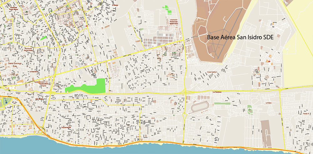
Extended Description of the Vector Map
Printable PDF Vector Map of Santo Domingo Metro Area Dominicana high detailed scale 1:4455 full editable Adobe PDF Street Map in layers, scalable, text/curves format all names, 72 MB ZIP
Covered Area: from San Cristobal to Las Americas
All street names, Main Objects, Buildings. Map for design, printing, arts, projects, presentations, for architects, designers, and builders, business, logistics.

Santo Domingo Dominicana Metro Area PDF Vector Map Exact Extra High Detailed Street Map Adobe PDF in layers
Layers list:
- Legend
- Grids
- Labels of roads
- Names of places (city, hamlet, etc.)
- Names of objects (hospitals, parks, water)
- Names of main streets
- Names of secondary streets
- Names of principal buildings
- Arrows of streets
- Main Streets, roads,
- Railroads
- Secondary streets
- Buildings
- Buildings 2 transparent 50%
- Airports and heliports
- Water objects (rivers, lakes, ponds)
- Color fills (parks, hospital areas, land use, etc.)
- Islands
- Background and sea
The most exact and detailed map of the city in scale.
For Editing and High-Quality Printing
Santo Domingo, the capital of the Dominican Republic, is a vibrant city with a rich history and modern infrastructure. Its streets, roads, and squares reflect its colonial past as well as its contemporary development. Below is a list of some of the principal streets, roads, and squares in Santo Domingo:
Principal Streets and Roads
- Avenida George Washington (El Malecón)
- Known locally as “El Malecón,” this iconic oceanfront avenue stretches along the Caribbean Sea. It’s a popular spot for walking, jogging, and enjoying stunning sunset views. Lined with restaurants, hotels, and parks, it’s one of the city’s most recognizable landmarks.
- Avenida Winston Churchill
- A major thoroughfare in the Piantini district, this road connects various commercial and residential areas. It is known for its shopping centers, banks, and upscale businesses.
- Avenida Abraham Lincoln
- Located in the Gazcue neighborhood, this avenue is home to important institutions such as the National Theater and the Museum of Modern Art. It’s also a hub for cultural activities and events.
- Avenida Máximo Gómez
- Named after a national hero, this historic avenue runs through the Colonial Zone and other parts of the city. It is surrounded by historical buildings and monuments.
- Avenida 27 de Febrero
- One of the busiest roads in Santo Domingo, it connects the eastern and western parts of the city. Along its route are shopping malls, markets, and public transportation hubs.
- Avenida John F. Kennedy
- This wide boulevard serves as a key artery in the city, featuring embassies, government offices, and high-end residential complexes.
- Calle El Conde
- Located in the heart of the Colonial Zone, Calle El Conde is a pedestrian-only street filled with shops, cafes, and historic sites. It’s a must-visit for tourists exploring Old Santo Domingo.
- Autopista Duarte
- The main highway connecting Santo Domingo to the interior of the country, including Santiago and other cities. It starts near the city center and extends northward.
- Autopista Las Américas
- Another critical highway that links Santo Domingo to Punta Cana and other eastern destinations. It passes by the airport and industrial zones.
- Calle Padre Billini
- A charming street in the Colonial Zone lined with colorful colonial-era buildings, art galleries, and boutique stores.
Principal Squares
- Plaza de la Cultura
- Located in the Gazcue district, this square houses several cultural institutions, including the National Theater, the Museum of Modern Art, and the Library of the Dominican Republic. It’s a hub for arts and culture.
- Parque Colón (Columbus Park)
- Situated in the Colonial Zone, Parque Colón is one of the oldest squares in the Americas. It features a statue of Christopher Columbus and is surrounded by historic landmarks like the Cathedral of Santa María la Menor and the Alcázar de Colón.
- Plaza de España
- Adjacent to the Colonial Zone, this expansive plaza overlooks the Ozama River. It’s a popular spot for locals and tourists, offering scenic views and access to attractions like the Alcázar de Colón.
- Plaza de la Independencia (Independence Park)
- Also known as “Parque de la Independencia,” this central square honors the Dominican Republic’s independence. It is located near the National Palace and features statues commemorating national heroes.
- Plaza de San José
- A quaint square in the Colonial Zone, Plaza de San José is home to the Iglesia de San José, one of the oldest churches in the Americas.
- Parque Mirador Sur
- While not a traditional square, this large park on the western edge of the city offers green spaces, sports facilities, and beautiful views of the Caribbean Sea. It’s a favorite among joggers and families.
- Plaza Francia
- Located near the Colonial Zone, this French-inspired square hosts cultural events and exhibitions. It’s often used for concerts and festivals.
- Plaza Duarte
- Named after Juan Pablo Duarte, one of the founding fathers of the Dominican Republic, this square is found in the Ciudad Nueva neighborhood and serves as a gathering place for community events.
Other Notable Areas
- Zona Universitaria : Home to universities and student life, with busy streets like Avenida Alma Mater.
- Ensanche Naco : An affluent neighborhood with tree-lined streets and upscale boutiques.
- Gazcue : Known for its elegant architecture and proximity to cultural landmarks.
These streets, roads, and squares form the backbone of Santo Domingo’s urban landscape, blending history, culture, and modernity seamlessly. Whether you’re exploring the cobblestone streets of the Colonial Zone or cruising along El Malecón, each area offers a unique glimpse into the soul of the city.

Santo Domingo Dominicana Metro Area PDF Vector Map Exact Extra High Detailed Street Map Adobe PDF in layers

Santo Domingo Dominicana Metro Area PDF Vector Map Exact Extra High Detailed Street Map Adobe PDF in layers

Santo Domingo Dominicana Metro Area PDF Vector Map Exact Extra High Detailed Street Map Adobe PDF in layers

Santo Domingo Dominicana Metro Area PDF Vector Map Exact Extra High Detailed Street Map Adobe PDF in layers

Santo Domingo Dominicana Metro Area PDF Vector Map Exact Extra High Detailed Street Map Adobe PDF in layers

Santo Domingo Dominicana Metro Area PDF Vector Map Exact Extra High Detailed Street Map Adobe PDF in layers

Santo Domingo Dominicana Metro Area PDF Vector Map Exact Extra High Detailed Street Map Adobe PDF in layers

Santo Domingo Dominicana Metro Area PDF Vector Map Exact Extra High Detailed Street Map Adobe PDF in layers

Santo Domingo Dominicana Metro Area PDF Vector Map Exact Extra High Detailed Street Map Adobe PDF in layers

Santo Domingo Dominicana Metro Area PDF Vector Map Exact Extra High Detailed Street Map Adobe PDF in layers

Santo Domingo Dominicana Metro Area PDF Vector Map Exact Extra High Detailed Street Map Adobe PDF in layers
Santo Domingo Dominicana Metro Area PDF Vector Map Exact Extra High Detailed Street Map Adobe PDF in layers

Santo Domingo Dominicana Metro Area PDF Vector Map Exact Extra High Detailed Street Map Adobe PDF in layers

Santo Domingo Dominicana Metro Area PDF Vector Map Exact Extra High Detailed Street Map Adobe PDF in layers

Santo Domingo Dominicana Metro Area PDF Vector Map Exact Extra High Detailed Street Map Adobe PDF in layers

Santo Domingo Dominicana Metro Area PDF Vector Map Exact Extra High Detailed Street Map Adobe PDF in layers

Santo Domingo Dominicana Metro Area PDF Vector Map Exact Extra High Detailed Street Map Adobe PDF in layers

Santo Domingo Dominicana Metro Area PDF Vector Map Exact Extra High Detailed Street Map Adobe PDF in layers

Santo Domingo Dominicana Metro Area PDF Vector Map Exact Extra High Detailed Street Map Adobe PDF in layers

Santo Domingo Dominicana Metro Area PDF Vector Map Exact Extra High Detailed Street Map Adobe PDF in layers

Santo Domingo Dominicana Metro Area PDF Vector Map Exact Extra High Detailed Street Map Adobe PDF in layers

Santo Domingo Dominicana Metro Area PDF Vector Map Exact Extra High Detailed Street Map Adobe PDF in layers

Santo Domingo Dominicana Metro Area PDF Vector Map Exact Extra High Detailed Street Map Adobe PDF in layers

 Author: Kirill Shrayber, Ph.D. FRGS

