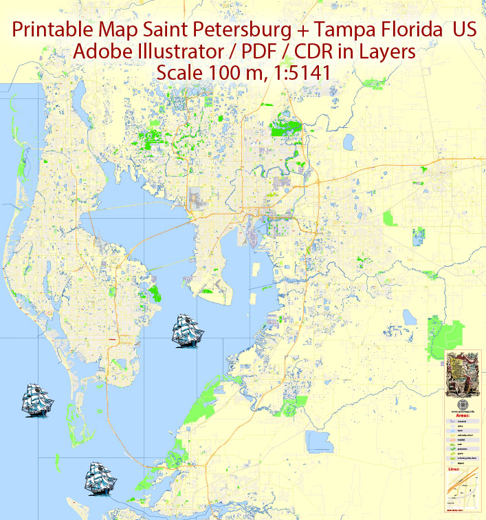
Printable PDF Map Saint Petersburg & Tampa Metro Area, Florida US, exact vector City Plan scale 1:5141, full editable, Adobe PDF Street Map in Layers, text format all names, 31 mb ZIP
All streets named, Main Objects. Map for design, printing, arts, projects, presentations, for architects, designers and builders, business, logistics.
Layers: color_fills, streets_roads, names_sreets, names_places, arrows_streets, labels_roads, names_objects, water_1, water_2, grids, legend.
The most exact and detailed map of the city.
DWG, DXF, EPS and other formats – on request, same price, please, contact
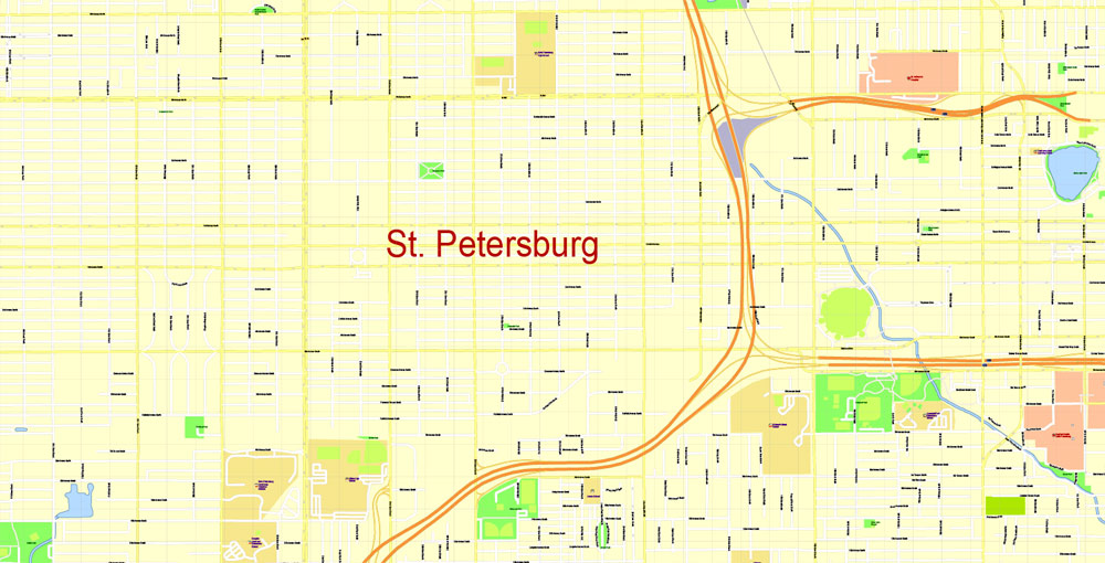
St. Petersburg, Florida – the city of sun and oranges
Sunny beaches all year round, palm trees, yachts, a sea of flowers, yellow excursion trams – this is how the city of St. Petersburg looks like a popular holiday destination for people with affluence.
Only it is located on the shore of the Gulf of Mexico, not the Gulf of Finland, in the US state of Florida. And although there are dozens of St. Petersburg, as well as Rome and Paris, in America, this “Saint-Pete“, as the locals call it, is special. At least because there is simply no such number of coincidences with the namesake city.
The city should be!
And coincidences are amazing. The American St. Petersburg was founded in August 1888, by Peter, too, and also by Alekseevich – Peter Alekseevich Dementiev, a Russian nobleman, entrepreneur, and later a writer who emigrated to America in 1881. According to legend, Peter Dementiev, who became Peter Demens in America, and his companion John Williams tossed a coin for the right to name a new city.
The more fortunate Demens then named a small village in honor of the capital of the Russian Empire, where he had lived before. This legend, which, according to Dementiev’s biographer Albert Perry, is nothing more than a “red word” (the agreement was concluded in a purely business way), is loved by its residents and is passed from mouth to mouth.
“Of course, we know why the city is called that. Take our menu, it says on the back that a Russian emigrant named it after he won a dispute with an American, and he named this hotel after his hometown,” says Natasha, a waitress at The Garden restaurant, located in the former Detroit Hotel, the very first hotel in the city.
Jason, the bartender at the Starbucks cafe, says he learned about Dementia at school. “I’ve been living here since I was born, and I think we were told at school about a Russian aristocrat who laid a railway and named our city after a city in Russia.”
His employee Amanda, laughing, admits that she knows about Russian St. Petersburg and just guessed where the name of the city came from: “I do not know this story, I went to school in Tampa.”
Another coincidence is geographical. “Saint-Pete”, like its Russian twin (by the way, quite official) appeared on a wasteland with a population of 30 people. And, like St. Petersburg, it is on the shore of the bay, thanks to which it quickly became a port center and a mecca of water tourism. It’s as if this Peter Alekseevich, a man, according to Albert Perry, of incredible energy and intelligence, who visited Russia as an officer of the imperial army and the leader of the nobility, was looking for the perfect place to build the city of his dreams. He has just chosen somewhat more humane ways to realize this dream.
The Road to Life
According to the archival records and articles of Demens himself, which he published in the journal “Bulletin of Europe” under the pseudonym V.A. Tverskaya, the city arose from almost nothing. First, Dementiev laid the first railroad in Florida and named it “Orange Ridge”. Then he built a depot, a pier, and the aforementioned Detroit Hotel, and also set a plan for the entire settlement.
“It’s amazing how well the original layout of the city has been preserved – streets, parks and reservoirs are now where they were from the very beginning, I can easily tell what all these streets are called now,” says Amelia Preston, an employee of the city hall, looking through a magnifying glass at the first map of the city from 1888. In addition to a couple of inscriptions in small italics on the map, there are only squares and lines…
But Howard Isaac, a local entrepreneur, believes that the look of Saint-Pete has changed, but not for the better. “I’ve been here since 1951 and I see the difference – the city used to be simpler and more beautiful, and there were fewer people.”
The Detroit Hotel, similar to the cottages of Russian aristocrats of the late XIX century, has been completely preserved from the Demens heritage. Today it is one of the most fashionable establishments in St. Petersburg, with its bakery, restaurant, bar, DJs, and lives music in the evenings.
Russian Russian musicians I don’t remember playing here, but there was a Bulgarian DJ, he played something in the style of hip-hop with obvious Russian motifs.” Russ, an employee of the restaurant, recalls: “I don’t remember that Russian musicians played here, but there was one Bulgarian DJ, he played something in the style of hip-hop with obvious Russian motives.”..
Most of the “Orange Ridge” is cemented under bicycle paths. There is an office building with restaurants on the site of the depot. But the pier has become a real asset of the city – it houses a yacht club, a respectable Renaissance Park Voit hotel, a lot of restaurants and recreation areas. In addition, a park called Demens Landing is divided into parts of the pier. Under one of the trees of the park near the water, the Congress of Russian Americans installed in 1979 a memorial pedestal in memory of Dementiev-Demens, the founder of the city of St. Petersburg.
Gallery of Images “Urban plan St Petersburg Florida pdf”:
St. Petersburg
City in Florida
St. Petersburg is a city on Florida’s gulf coast, part of the Tampa Bay area. It’s known for its pleasant weather (hence its “Sunshine City” nickname), making it popular for golfing, boating, fishing and beachgoing. Its waterfront parks host the Dali Museum, featuring surrealist works of art; the Museum of Fine Arts, with works ranging from ancient to contemporary; and Mahaffey Theater, home of the Florida Orchestra.
Area
• City 137.64 sq mi (356.50 km2)
• Land 61.75 sq mi (159.94 km2)
• Water 75.89 sq mi (196.56 km2)
Elevation 44 ft (13.4 m)
Population
• City 244,769
• Estimate 260,999
• Rank 79th
• Density 4,226.57/sq mi (1,631.90/km2)
• Urban 2,441,770 (17th)
• Metro 2,870,569 (18th)
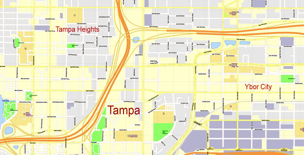
Tampa
City in Florida
Tampa is a city on Tampa Bay, along Florida’s Gulf Coast. A major business center, it’s also known for its museums and other cultural offerings. Busch Gardens is an African-themed amusement park with thrill rides and animal-viewing areas. The historic Ybor City neighborhood, developed by Cuban and Spanish cigar-factory workers at the turn of the 20th century, is a dining and nightlife destination.
Area
• City 175.22 sq mi (453.81 km2)
• Land 113.42 sq mi (293.75 km2)
• Water 61.80 sq mi (160.06 km2) 35.3%
• Urban 802.3 sq mi (2,078 km2)
• Metro 2,554 sq mi (6,610 km2)
Elevation 48 ft (14.6 m)
Population
• City 335,709
• Estimate 377,165
• Rank 52nd in the US
• Density 3,325.47/sq mi (1,283.97/km2)
• Urban 2.4 million (17th)
• Metro 3,068,511

Free Download Vector Map US County and State Adobe Illustrator
Free_Vector_Map_US_States_County_Map.ai
Free Download Vector Map US County and State Adobe PDF
Free_Vector_Map_US_States_County_Map.pdf

Free Download Vector Map US With States Names, Adobe Illustrator
Free_Map_of_USA_with_state_names_en.ai
Free Download Vector Map US With States Names, Adobe PDF
Free_Map_of_USA_with_state_names_en.pdf
From WIKI
Free vector map World, Adobe Illustrator, download now maps vector clipart
Map for design, projects, presentation free to use as you like.
See also: TERMS & CONDITIONS: SOFTWARE LICENSE AGREEMENT FOR DIGITAL CARTOGRAPHIC DATA.
Need more USA Vector Maps, printable and editable?


 Author: Kirill Shrayber, Ph.D. FRGS


