Printable Map Menlo Park, California, exact vector street 2000 meter scale City Plan, fully editable, Adobe Illustrator, full vector, scalable, editable text format of street names, 2 Mb ZIP.
All streets, named Principal streets, main objects. Map for publishing, design, printing, publications, arts, projects, presentations, for architects, designers and builders, business, logistics. The most exact and detailed map of the city.
Royalty Free.
DXF, CDR and other formats – by request, same price, please contact.
Menlo Park, California, USA.
This vector map of Menlo Park is used as a basis for design, editing, and further printing.
This is the most detailed, exact map of Menlo Park for high-quality printing and polygraphy. You can always clarify the map development date by contacting us.
For your convenience, all objects on Menlo Park vector map are divided into layers. And the editing is very easy – colors, lines, etc.
You can easily add any objects needed (e.g. shops, salons, sale points, gas station or attraction) on any layer of Menlo Park vector map.
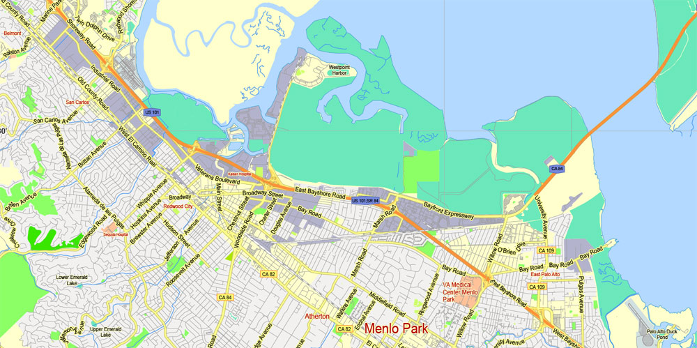
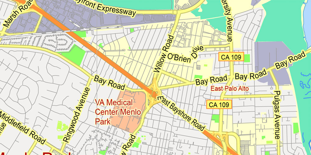
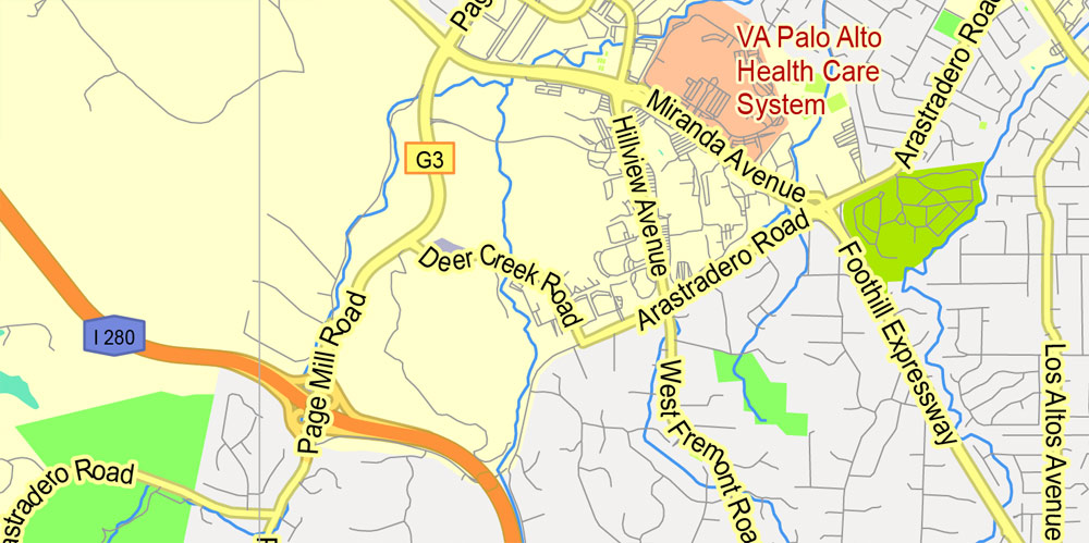
Menlo Park is a city at the eastern edge of San Mateo County, in the San Francisco Bay Area of California, in the United States. It is bordered by San Francisco Bay on the north and east; East Palo Alto, Palo Alto, and Stanford to the south; Atherton, North Fair Oaks, and Redwood City to the west. Menlo Park is one of the most educated cities in the state of California and the United States; nearly 70% of residents over the age of 25 has earned a bachelor’s degree or higher. Menlo Park had 32,026 inhabitants according to the 2010 United States Census, which had grown to an estimated 33,888 inhabitants by 2016. Menlo Park is the site of Facebook’s main campus.
One of the advantages of Menlo Park vector maps of our production is the relevance of cartographic data, we constantly update all our products.
This vector map of Menlo Park is used by:
designers, layout designers, printers, advertisers and architects. Our product – vector maps – is designed for further editing and printing in large formats – from @Wall format (a few meters) to A-0 and A-1, A-2, A-3.
Menlo Park map in vector format is used for design, urban planning, presentations and media visualizations.
Advertising and presentation map of Menlo Park (usually the final designer marks the routes, and puts the client’s objects (shops, saloons, gas stations etc.)
The undoubted advantage is that people will NEVER throw out this advertising product – the map. In fact, as an advertising medium, a map is the most “long-playing” of the well-known polygraphic advertising media, with the longest lifespan, and the maximum number of interactions with the customer.
For travelers, maps are sold at the airports and gas stations around the world. Often the source is our vector maps.
Take a look, who purchases our vector maps of Menlo Park in “Our Clients and Friends” page – these are large and small companies, from super-brands like Volvo and Starbucks, to small design studios and printing houses.
It’s very easy to work with vector maps of Menlo Park, even for a not very experienced designer who can turn on and off the map layers, add new objects, change the colors of fill and lines according to customer requirements.
The undoubted advantage of Menlo Park vector maps in printing is an excellent and detailed visualization, when customer can expand a large paper map and instantly define his location, find a landmark, an object or address on map, unlike using the popular electronic formats of Google and Yandex maps for example.
Printable vector maps of Menlo Park are much more convenient and efficient than any electronic maps on your smartphone, because ALL DETAILS are displayed in the entire space of Menlo Park map.
Useful tips on working with vector maps of cities and countries in Adobe Illustrator.
«V» – launches the Selection tool (cursor, black arrow), which makes active any vector line.
«А» – launches the Direct Selection tool (white cursor), allows you to select curve elements and drag them to the desired place.
«R» – activates the Rotate tool, which helps you rotating selected objects around the center point by 360 degrees.
«E» – gives you the opportunity to use the Eraser tool and erase unnecessary parts.
«X» – switches between Fill and Stroke in the Tools section. Try to get used to this hot key and
you will quickly understand that you can’t live and work without it.
Guides are not limited to vertical and horizontal in Adobe Illustrator. You can also create a diagonal guide for example. Moreover, you can turn any contours into guides. Select the outline and go to View > Guides > Make Guides (Create Guides), or simply press Cmd/Ctrl + 5. You can also turn the guides back into an editable object. Go to menu, View > Guides > Unlock Guides (Release Guides), select the guide you want to edit and select View > Guides > Release Guides (Reset Guides), or just press Cmd/Ctrl + Option / Alt + 5).
You will probably want to change the color scheme used on our Menlo Park vector map.
To quickly and effectively play with colors.
Of course, you can do it manually, all objects in our Menlo Park vector map are divided according to types and layers, and you can easily change the color gamma of vector objects in groups and layers.
But there is more effective way of working with the whole VECTOR MAP of Menlo Park and all layers:
The overview dialog «Edit colors»/«Repaint Graphic Object» (this dialog box name can change depending on the context):
If you have selected a part or a layer of Menlo Park vector map and open the dialog box by clicking the icon in the Control panel, on the Samples palette or the Color Catalog, or if you choose Edit > Edit Colors> Repaint Graphic Object, then the «Repaint Graphic Object» dialog box appears, and you get access to «Assign» and «Edit» tabs.
If a picture or a map fragment is not selected, and you open the dialog box by clicking the icon in the Control panel, on the Samples palette or in the Color Catalog, the «Edit Colors» dialog box appears and you can only access the «Edit» tab.
Regardless of the name at the top of the dialog box, the right-hand side always displays the color group of the current document, as well as two default color groups: Print Color and Grayscale. These color groups can be selected and used any time.
Create and edit color groups of Menlo Park vector map, and also assign colors using the «Edit Colors»/ а «Repaint Graphic Object» dialog box.
A. Creating and editing of a color group on the «Edit» tab
B. Assigning colors on the «Assign» tab
C. Select a group of colors from the «Color groups» list
The option «Repaint a graphic object» in the lower part of the dialog box allows you to preview the colors on a selected layer of Vector map, or a group of elements, and specify whether its colors will be redefined when the dialog box is closed.
The main areas of the dialog box are:
«Edit»
The «Edit» tab is designed to create a new or edit the existing color groups.
The harmony rules Menu and the Color Wheel are used to conduct experiments with color harmonies. The color wheel shows how colors are related in color harmony, and the color bars allow you to view and manipulate an individual color values. In addition, you can adjust the brightness, add and remove colors, save color groups and view colors on the selected Vector Map of Menlo Park or a separated layers.
«Assign»
The «Assign» tab is used to view and control on how the original colors are replaced with colors from the color group like your corporate colors in the Vector Map of Menlo Park.
The assign color ability is provided only if the entire map, layer or fragment is selected in the document. You can specify which of new colors replace the current colors, whether the spot colors should be preserved and how colors are replaced (for example, you can replace colors completely or changing the color tone while maintaining the brightness). The «Assign» tab allows you to redefine colors in the Vector Map of Menlo Park, or in separate layers and fragments using the current color group or reducing the number of colors in the current Vector Map.
Color groups
Is a list of all saved color groups for current document (the same groups appear in the «Samples» palette). You can edit and delete the existing color groups, as well as creating a new ones using the list of “Color Groups” in the dialog box. All changes appear in the «Samples» palette.
The highlighted color group shows, which color group is currently edited.
Any color group can be selected and edited, or used to redefine the colors in the selected vector map of Menlo Park , its fragments or elements.
Saving a color group adds this group to the specified list.
Opening the «Edit Colors»/«Repaint Graphic Object» dialog box.
Open the «Edit Colors»/«Repaint Graphic Object» dialog box using one of the following methods:
«Edit»> «Edit Colors»> «Repaint Graphic object» or «Repaint With Style».
Use these commands if you need to edit the colors in the selected vector map of Menlo Park city.
«Repaint Graphic object» button on the «Control» panel.
Use this button if you need to adjust colors of Menlo Park vector map using the а «Repaint graphic object» dialog box.
The specified button is available if the selected vector map or its fragment contains two or more colors.
Note. This color editing method is convenient for global color adjustment in a vector map, if global colors were not used when creating a Map of Menlo Park.
The «Edit colors» button or «Edit or apply colors» on the «Color Catalog» palette
Click this button if you need to edit colors on the «Color Catalog» palette or edit and then apply them to the selected Vector Map of Menlo Park or its fragment.
The «Edit color group» button or «Edit or apply color group» on the «Samples» palette.
Click this button if you need to edit the colors in the specific color group or edit and apply them to the selected Vector Map of Menlo Park or a group of its elements, for example, the whole layer “Streets and lines”. You can also double-click the color group in the Samples panel to open the dialog box.
If the map file is too large and your computer freezes or even can’t open it quickly:
1. Try to reduce the color resolution of the video card (display) to 256 colors while working with a large map.
2. Using Windows Task Manager, select all the application you don’t need, while working with map, just turn them off.
3. Launch Adobe Illustrator. (DO NOT OPEN the vector map file)
4. Start the Windows Task Manager using administrator rights > Find the “Illustrator” process > set the «real time» priority,
5. Open the file. When you see the LEGACY FONT popup window – click “OK” (do not update). You can restore the TEXT later.
6. Can also be useful: When file is opened – Edit > Settings > Basic Settings > disable smoothing. /// It looks scary, but works quickly)))
We recommend saving the file in Adobe Illustrator 10 version. It’s much more stable when working with VERY BIG size files.
Geography
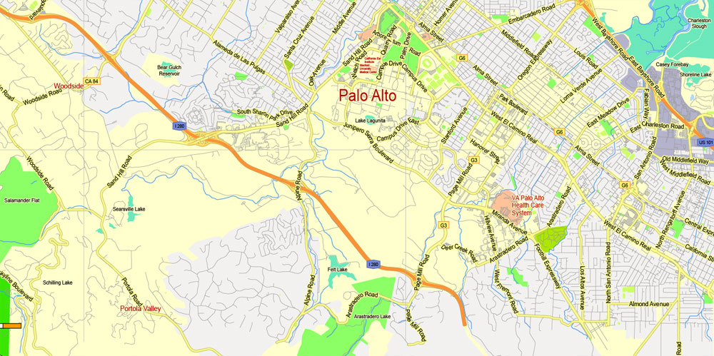
According to the United States Census Bureau, the city has a total area of 17.4 square miles (45 km2), of which 9.8 square miles (25 km2) is land and 7.6 square miles (20 km2) is water. The total area is 43.79% water. Menlo Park is long and narrow on a northeast to southwest axis. The northeast portion borders the San Francisco Bay and includes the Dumbarton Bridge that connects Menlo Park to Fremont on the east side of the bay. The city shoreline includes the city’s largest park, Bedwell Bayfront Park 160 acres (65 ha) and the Don Edwards San Francisco Bay National Wildlife Refuge. San Francisquito Creek marks much of the southeast border of the city. West Menlo Park (not part of the city despite its name) along Alameda de las Pulgas nearly separates the southwestern part of the city (known as Sharon Heights) from the rest. The extreme southwest is clipped by Interstate 280.
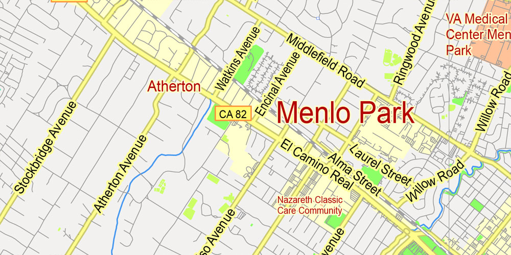
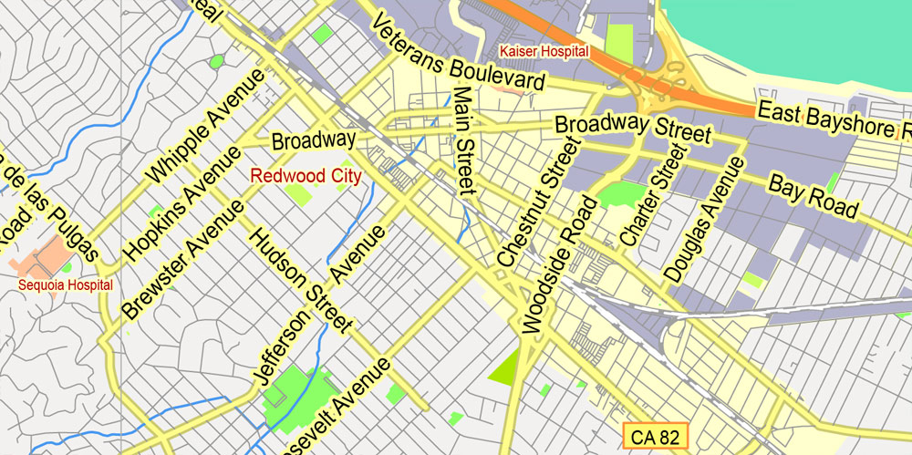
The Bayshore Freeway (part of U.S. Route 101) traverses Menlo Park northwest to southeast near the shoreline and somewhat parallel to it to the southwest is El Camino Real. The intersection of El Camino Real and Santa Cruz Avenue is considered the heart of the city. Nearby, the Menlo Park Civic center is bounded by Ravenswood Avenue, Alma Street, Laurel Street and Burgess Drive. It contains the council offices, library, police station and Burgess Park which has various recreational facilities. Other major roads include Sand Hill Road in the Sharon Heights area.
The residential areas of Menlo Park are unofficially divided into several neighborhoods. Belle Haven is the only neighborhood east of the Bayshore Freeway; much of the rest of that area is business or protected land. Between Middlefield road (a road almost parallel to Bayshore) and Bayshore are the neighborhoods of the Willows, Suburban Park, Lorelei Manor, Flood Triangle, Vintage Oaks, and South of Seminary (the seminary being Saint Patrick’s Seminary). Between Middlefield and El Camino Real are Felton Gables, Linfield Oaks, and Park Forest. West of El Camino Real until the hills are the neighborhoods of Downtown Menlo Park, Central Menlo Park, and Allied Arts (sometimes also known as Stanford Park, it is named for the Allied Arts Guild in it). In the hills are Sharon Heights and Stanford Hills. Several other neighborhoods are closely associated with Menlo Park but are actually in unincorporated San Mateo county; these include Menlo Oaks and Fair Oaks (latter part of the North Fair Oaks census area) between Bayshore and Middlefield, University Heights (also known as West Menlo Park) between Sharon Heights and most of the rest of the city, and Stanford Weekend Acres which is somewhat near Stanford Hills.
Free vector maps:

Free download Vector Map US Interstate roads, Adobe PDF, V.2 Free_Map_US_Interstates_Roads_2.pdf
Free download Vector Map US Interstate roads, Adobe Illustrator, V.2 Free_Map_US_Interstates_Roads_2.ai

Free Download Vector Map US County and State Adobe Illustrator
Free_Vector_Map_US_States_County_Map.ai
Free Download Vector Map US County and State Adobe PDF
Free_Vector_Map_US_States_County_Map.pdf

Free Vector Map US Census Data Top US Ancestries by County Adobe Illustrator
Free_Vector_Map_US_Census-Data-Top-US-Ancestries-by-County.ai
Free Vector Map US Census Data Top US Ancestries by County Adobe PDF
Free_Vector_Map_US_Census-Data-Top-US-Ancestries-by-County.pdf
Menlo Park, California
Menlo Park is a city at the eastern edge of San Mateo County, in the San Francisco Bay Area of California, in the United States. It is bordered by San Francisco Bay on the north and east; East Palo Alto, Palo Alto, and Stanford to the south; Atherton, North Fair Oaks, and Redwood City to the west. Menlo Park is one of the most educated cities in the state of California and the United States, with nearly 70% of its residents having earned a degree. Menlo Park had 32,026 inhabitants according to the 2010 United States Census.
Geography of Menlo Park, California, United States
According to the United States Census Bureau, the city has a total area of 17.4 square miles (45 km2), of which 9.8 square miles (25 km2) is land and 7.6 square miles (20 km2) is water. The total area is 43.79% water. The main street in downtown Menlo Park is Santa Cruz Avenue, with the Menlo Center situated at its intersection with El Camino Real. The Menlo Park Civic Center is bounded by Ravenswood Avenue, Alma Street, Laurel Street and Burgess Drive. It contains the council offices, library, police station and Burgess Park which has various recreational facilities.
https://en.wikipedia.org/wiki/Menlo_Park,_California#Geography
 map, fully editable, Adobe PDF")

 Author: Kirill Shrayber, Ph.D. FRGS

