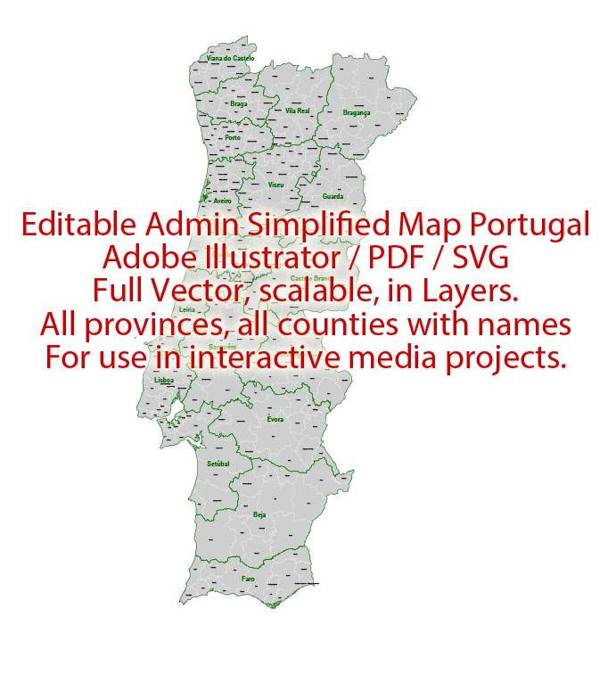
Administrative Vector Map Portugal Adobe Illustrator Editable PDF SVG layers simplified Provinces Counties for use in the interactive media projects special edition
Layers: Counties_with_names, Borders_provinces, Names_provinces.
Text format all names
Ready for use in interactive media projects such as http://jvectormap.com/ or jQuery Mapael https://www.vincentbroute.fr/mapael/ https://github.com/neveldo/jQuery-Mapael
Portugal.
This vector map of Portugal is used as a basis for design, editing, and further printing.
This is the most detailed, exact map of Portugal for high-quality printing and polygraphy. You can always clarify the map development date by contacting us.
For your convenience, all objects on Portugal vector map are divided into layers. And the editing is very easy – colors, lines, etc.
You can easily add any objects needed (e.g. shops, salons, sale points, gas station or attraction) on any layer of Portugal vector map.
Portugal is a country located mostly on the Iberian Peninsula in southwestern Europe. It is the westernmost sovereign state of mainland Europe. It is bordered to the west and south by the Atlantic Ocean and to the north and east by Spain. Its territory also includes the Atlantic archipelagos of the Azores and Madeira, both autonomous regions with their own regional governments.
One of the advantages of Portugal vector maps of our production is the relevance of cartographic data, we constantly update all our products.
This vector map of Portugal is used by:
designers, layout designers, printers, advertisers and architects. Our product – vector maps – is designed for further editing and printing in large formats – from @Wall format (a few meters) to A-0 and A-1, A-2, A-3.
The Portugal map in vector format is used for design, urban planning, presentations and media visualizations.
The advertising and presentation map of Portugal (usually the final designer marks the routes, and puts the client’s objects (shops, saloons, gas stations etc.)
The undoubted advantage is that people will NEVER throw out this advertising product – the map. In fact, as an advertising medium, a map is the most “long-playing” of the well-known polygraphic advertising media, with the longest lifespan, and the maximum number of interactions with the customer.
For travelers, maps are sold at the airports and gas stations around the world. Often the source is our vector maps.
Take a look, who purchases our vector maps of Portugal in “Our Clients and Friends” page – these are large and small companies, from super-brands like Volvo and Starbucks, to small design studios and printing houses.
It’s very easy to work with vector maps of Portugal city, even for a not very experienced designer who can turn on and off the map layers, add new objects, change the colors of fill and lines according to customer requirements.
The undoubted advantage of Portugal vector maps in printing is an excellent and detailed visualization, when customer can expand a large paper map and instantly define his location, find a landmark, an object or address on map, unlike using the popular electronic formats of Google and Yandex maps for example.
Printable vector maps of Portugal are much more convenient and efficient than any electronic maps on your smartphone, because ALL DETAILS are displayed in the entire space of Portugal map.
Useful tips on working with vector maps of cities and countries in Adobe Illustrator.
«V» – launches the Selection tool (cursor, black arrow), which makes active any vector line.
«А» – launches the Direct Selection tool (white cursor), allows you to select curve elements and drag them to the desired place.
«R» – activates the Rotate tool, which helps you rotating selected objects around the center point by 360 degrees.
«E» – gives you the opportunity to use the Eraser tool and erase unnecessary parts.
«X» – switches between Fill and Stroke in the Tools section. Try to get used to this hot key and
you will quickly understand that you can’t live and work without it.
Guides are not limited to vertical and horizontal in Adobe Illustrator. You can also create a diagonal guide for example. Moreover, you can turn any contours into guides. Select the outline and go to View > Guides > Make Guides (Create Guides), or simply press Cmd/Ctrl + 5. You can also turn the guides back into an editable object. Go to menu, View > Guides > Unlock Guides (Release Guides), select the guide you want to edit and select View > Guides > Release Guides (Reset Guides), or just press Cmd/Ctrl + Option / Alt + 5).
You will probably want to change the color scheme used on our Portugal vector map.
To quickly and effectively play with colors.
Of course, you can do it manually, all objects in our Portugal vector map are divided according to types and layers, and you can easily change the color gamma of vector objects in groups and layers.
But there is more effective way of working with the whole VECTOR MAP of Portugal and all layers:
The overview dialog «Edit colors»/«Repaint Graphic Object» (this dialog box name can change depending on the context):
If you have selected a part or a layer of Portugal vector map and open the dialog box by clicking the icon in the Control panel, on the Samples palette or the Color Catalog, or if you choose Edit > Edit Colors> Repaint Graphic Object, then the «Repaint Graphic Object» dialog box appears, and you get access to «Assign» and «Edit» tabs.
If a picture or a map fragment is not selected, and you open the dialog box by clicking the icon in the Control panel, on the Samples palette or in the Color Catalog, the «Edit Colors» dialog box appears and you can only access the «Edit» tab.
Regardless of the name at the top of the dialog box, the right-hand side always displays the color group of the current document, as well as two default color groups: Print Color and Grayscale. These color groups can be selected and used any time.
Create and edit color groups of Portugal vector map, and also assign colors using the «Edit Colors»/ а «Repaint Graphic Object» dialog box.
A. Creating and editing of a color group on the «Edit» tab
B. Assigning colors on the «Assign» tab
C. Select a group of colors from the «Color groups» list
The option «Repaint a graphic object» in the lower part of the dialog box allows you to preview the colors on a selected layer of Vector map, or a group of elements, and specify whether its colors will be redefined when the dialog box is closed.
The main areas of the dialog box are:
«Edit»
The «Edit» tab is designed to create a new or edit the existing color groups.
The harmony rules Menu and the Color Wheel are used to conduct experiments with color harmonies. The color wheel shows how colors are related in color harmony, and the color bars allow you to view and manipulate an individual color values. In addition, you can adjust the brightness, add and remove colors, save color groups and view colors on the selected Vector Map of Portugal or a separated layers.
«Assign»
The «Assign» tab is used to view and control on how the original colors are replaced with colors from the color group like your corporate colors in the Vector Map of Portugal city.
The assign color ability is provided only if the entire map, layer or fragment is selected in the document. You can specify which of new colors replace the current colors, whether the spot colors should be preserved and how colors are replaced (for example, you can replace colors completely or changing the color tone while maintaining the brightness). The «Assign» tab allows you to redefine colors in the Vector Map of Portugal city, or in separate layers and fragments using the current color group or reducing the number of colors in the current Vector Map.
Color groups
Is a list of all saved color groups for current document (the same groups appear in the «Samples» palette). You can edit and delete the existing color groups, as well as creating a new ones using the list of “Color Groups” in the dialog box. All changes appear in the «Samples» palette.
The highlighted color group shows, which color group is currently edited.
Any color group can be selected and edited, or used to redefine the colors in the selected vector map of Portugal city, its fragments or elements.
Saving a color group adds this group to the specified list.
Opening the «Edit Colors»/«Repaint Graphic Object» dialog box.
Open the «Edit Colors»/«Repaint Graphic Object» dialog box using one of the following methods:
«Edit»> «Edit Colors»> «Repaint Graphic object» or «Repaint With Style».
Use these commands if you need to edit the colors in the selected vector map of Portugal city.
«Repaint Graphic object» button on the «Control» panel.
Use this button if you need to adjust colors of Portugal vector map using the а «Repaint graphic object» dialog box.
The specified button is available if the selected vector map or its fragment contains two or more colors.
Note. This color editing method is convenient for global color adjustment in a vector map, if global colors were not used when creating a Map of Portugal.
The «Edit colors» button or «Edit or apply colors» on the «Color Catalog» palette
Click this button if you need to edit colors on the «Color Catalog» palette or edit and then apply them to the selected Vector Map of Portugal or its fragment.
The «Edit color group» button or «Edit or apply color group» on the «Samples» palette.
Click this button if you need to edit the colors in the specific color group or edit and apply them to the selected Vector Map of Portugal or a group of its elements, for example, the whole layer “Streets and lines”. You can also double-click the color group in the Samples panel to open the dialog box.
If the map file is too large and your computer freezes or even can’t open it quickly:
1. Try to reduce the color resolution of the video card (display) to 256 colors while working with a large map.
2. Using Windows Task Manager, select all the application you don’t need, while working with map, just turn them off.
3. Launch Adobe Illustrator. (DO NOT OPEN the vector map file)
4. Start the Windows Task Manager using administrator rights > Find the “Illustrator” process > set the «real time» priority,
5. Open the file. When you see the LEGACY FONT popup window – click “OK” (do not update). You can restore the TEXT later.
6. Can also be useful: When file is opened – Edit > Settings > Basic Settings > disable smoothing. /// It looks scary, but works quickly)))
We recommend saving the file in Adobe Illustrator 10 version. It’s much more stable when working with VERY BIG size files.
Portugal is the oldest state on the Iberian Peninsula and one of the oldest in Europe, its territory having been continuously settled, invaded and fought over since prehistoric times. The Pre-Celts, Celts, Carthaginians and Romans were followed by the invasions of the Visigoths and Suebi Germanic peoples.
Portugal as a country was established during the Christian Reconquista against the Moors who had invaded the Iberian Peninsula in 711 AD. Despite attempts at independence since its foundation as a county in 868, only after the Battle of São Mamede in 1128, where Portuguese forces led by Afonso Henriques defeated forces led by his mother, Theresa of Portugal, the County of Portugal affirmed its sovereignty and Henriques styled himself Prince of Portugal. He would later be proclaimed King of Portugal at the Battle of Ourique in 1139 and was recognised as such, by neighbouring kingdoms, on the Treaty of Zamora, in 1143. In the 15th and 16th centuries, Portugal established the first global empire, becoming one of the world’s major economic, political and military powers. During this period, today referred to as the Age of Discovery, Portuguese explorers pioneered maritime exploration, notably under royal patronage of Prince Henry the Navigator and King John II, with such notable voyages as Bartolomeu Dias’ sailing beyond the Cape of Good Hope (Cabo da Boa Esperança) (1488), Vasco da Gama’s discovery of the sea route to India (1497–98) and the European discovery of Brazil (1500).
During this time Portugal monopolized the spice trade, and the empire expanded with military campaigns in Asia. However, events such as the destruction of Lisbon in a 1755 earthquake, the Industrial Revolution, the Seven Years’ War, the country’s occupation during the Napoleonic Wars, and the independence of Brazil (1822), erased to an extent Portugal’s prior opulence.
After the 1910 revolution deposed the monarchy, the democratic but unstable Portuguese First Republic was established, later being superseded by the Estado Novo right-wing authoritarian regime. Democracy was restored after the Carnation Revolution in 1974, ending the Portuguese Colonial War.
Shortly after, independence was granted to almost all its overseas territories. The handover of Macau to China in 1999 marked the end of what can be considered the longest-lived colonial empire.
Portugal has left a profound cultural and architectural influence across the globe, a legacy of 300 million Portuguese speakers, and many Portuguese-based creoles. A member of the United Nations and the European Union, Portugal was also one of the founding members of NATO, the eurozone, the OECD, and the Community of Portuguese Language Countries.
Portugal is a developed country with a high-income advanced economy and high living standards. It is the 4th most peaceful country in the world, and its state is the 15th most stable one, maintained under a unitary semi-presidential republican form of government. Additionally, the country ranks highly in terms of democracy (10th), social progress (20th), prosperity (25th), press freedom (14th), moral freedom (3rd), LGBTI rights (7th in Europe), ease of doing business (29th) and road network (2nd).
Geography
The territory of Portugal includes an area in the Iberian Peninsula (referred to as the continent by most Portuguese) and two archipelagos in the Atlantic Ocean: the archipelagos of Madeira and the Azores. It lies between latitudes 32° and 43° N, and longitudes 32° and 6° W.
Mainland Portugal is split by its main river, the Tagus, that flows from Spain and disgorges in Tagus Estuary, in Lisbon, before escaping into the Atlantic. The northern landscape is mountainous towards the interior with several plateaus indented by river valleys, whereas the south, including the Algarve and the Alentejo regions, is characterized by rolling plains.
Portugal’s highest peak is the similarly named Mount Pico on the island of Pico in the Azores. This ancient volcano, which measures 2,351 m (7,713 ft) is an iconic symbol of the Azores, while the Serra da Estrela on the mainland (the summit being 1,991 m (6,532 ft) above sea level) is an important seasonal attraction for skiers and winter sports enthusiasts.
The archipelagos of Madeira and the Azores are scattered within the Atlantic Ocean: the Azores straddling the Mid-Atlantic Ridge on a tectonic triple junction, and Madeira along a range formed by in-plate hotspot geology. Geologically, these islands were formed by volcanic and seismic events. The last terrestrial volcanic eruption occurred in 1957–58 (Capelinhos) and minor earthquakes occur sporadically, usually of low intensity.
Portugal’s exclusive economic zone, a sea zone over which the Portuguese have special rights over the exploration and use of marine resources, has 1,727,408 km². This is the 3rd largest exclusive economic zone of the European Union and the 11th largest in the world.
Portugal is a coastal nation in southwestern Europe, located at the western end of the Iberian Peninsula, bordering Spain (on its northern and eastern frontiers: a total of 1,214 kilometres (754 mi)). The Portuguese territory also includes a series of archipelagos in the Atlantic Ocean (the Açores and Madeira), which are strategic islands along the North Atlantic. The extreme south is not too far from the Strait of Gibraltar, leading to the Mediterranean Sea. In total, the country occupies an area of 92,090 square kilometres (35,560 sq mi) of which 91,470 square kilometres (35,320 sq mi) is land and 620 square kilometres (240 sq mi) water.
Despite these definitions, the Portugal-Spain border remains an unresolved territorial dispute between the two countries. Portugal does not recognise the border between Caia and Ribeira de Cuncos River deltas, since the beginning of the 1801 occupation of Olivenza by Spain. This territory, though under de facto Spanish occupation, remains a de jure part of Portugal, consequently no border is henceforth recognised in this area.
Coastline
The continental shelf has an area of 28,000 square kilometres (11,000 sq mi), although its width is variable from 150 kilometres (93 mi) in the north to 25 kilometres (16 mi) in the south. Its strong relief is marked by deep submarine canyons and the continuation of the main rivers. The Estremadura Spur separates the Iberian Abyssal and Tagus Abyssal Plains, while the continental slope is flanked by sea-mounts and abuts against the prominent Gorringe Bank in the south. Currently, the Portuguese government claims a 200-metre (660 ft) depth, or to a depth of exploitation.
The Portuguese coast is extensive; in addition to approximately 943 kilometres (586 mi) along the coast of continental Portugal, the archipelagos of the Azores (667 km) and Madeira (250 km) are primarily surrounded by rough cliff coastlines. Most of these landscapes alternate between rough cliffs and fine sand beaches; the region of the Algarve is recognized for its sandy beaches popular with tourists, while at the same time its steep coastlines around Cape St. Vincent is well known for steep and foreboding cliffs. An interesting feature of the Portuguese coast is Ria Formosa with some sandy islands and a mild and pleasant climate characterized by warm but not very hot summers and generally mild winters.
Alternatively, the Ria de Aveiro coast (near Aveiro, referred to as “The Portuguese Venice”), is formed by a delta (approximately 45 kilometres (28 mi) length and a maximum 11 kilometres (6.8 mi) width) rich in fish and seabirds. Four main channels flow through several islands and islets at the mouth of the Vouga, Antuã, Boco, and Fontão Rivers. Since the 16th century, this formation of narrow headlands formed a lagoon, that, due to its characteristics allowed the formation and production of salt. It was also recognized by the Romans, whose forces exported its salt to Rome (then seen as a precious resource).
The Azores are also sprinkled with both alternating black sand and boulder-lined beaches, with only a rare exception, is their a white sand beach (such as on the island of Santa Maria in Almagreira. The island of Porto Santo is one of the few extensive dune beaches in Portugal, located in the archipelago of Madeira.
Tidal gauges along the Portuguese coast have identified a 1–1.5 millimetres (0.039–0.059 in) rise in sea levels, causing large estuaries and inland deltas in some major rivers to overflow.
As a result of its maritime possessions and coastline, Portugal has the third largest Exclusive Economic Zone of the European Union countries (and eleventh in the world). The sea-zone, over which Portugal exercises special territorial rights over the economic exploration and use of marine resources encircles an area of 1,727,408 square kilometres (666,956 sq mi) (divided as: Continental Portugal 327,667 km2, Azores Islands 953,633 km2, Madeira Islands 446,108 km2).
Portugal
Country
Portugal is a southern European country on the Iberian Peninsula, bordering Spain. Its location on the Atlantic Ocean has influenced many aspects of its culture: salt cod and grilled sardines are national dishes, the Algarve’s beaches are a major destination and much of the nation’s architecture dates to the 1500s–1800s, when Portugal had a powerful maritime empire.
Capital: Lisbon
Dialing code: +351
Population: 10.32 million (2016) World Bank
Capital and largest city: Lisbon; 38°46′N 9°9′W / 38.767°N 9.150°W

 Author: Kirill Shrayber, Ph.D. FRGS
