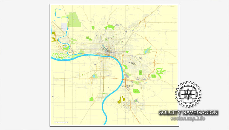
Sioux City, Iowa, US printable vector street City Plan map, full editable, Adobe PDF, full vector, scalable, editable, text format street names, 5 mb ZIP
All streets, some more buildings. Map for design, print, arts, projects, presentations,
for architects, designers and builders.
You can edit this file by Adobe Illustrator, Adobe Acrobat, Corel Draw.
DXF, DWG, CDR and other formats – on request, same price, please, contact
Sioux City, Iowa, USA.
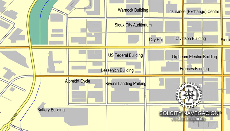
This vector map of Sioux City is used as a basis for design, editing, and further printing.
This is the most detailed, exact map of Sioux City for high-quality printing and polygraphy. You can always clarify the map development date by contacting us.
For your convenience, all objects on Sioux City vector map are divided into layers. And the editing is very easy – colors, lines, etc.
You can easily add any objects needed (e.g. shops, salons, sale points, gas station or attraction) on any layer of Sioux City vector map.
Sioux City is a city in Woodbury and Plymouth counties in the northwestern part of the U.S. state of Iowa. The population was 82,684 in the 2010 census, which makes it the fourth largest city in Iowa. The bulk of the city is in Woodbury County, of which it is the county seat, though a small portion is in Plymouth County. Sioux City is located at the navigational head of the Missouri River. The city is home to several cultural points of interest including the Sioux City Public Museum, Sioux City Art Center and Sergeant Floyd Monument, which is a National Historical Landmark. The city is also home to Chris Larsen Park, commonly referred to as “the Riverfront,” includes the Anderson Dance Pavilion, Sergeant Floyd Riverboat Museum and Lewis and Clark Interpretive Center. Sioux City is the primary city of the five-county Sioux City, IA–NE–SD Metropolitan Statistical Area (MSA), with a population of 168,825 in 2010 and a slight increase to an estimated 168,921 in 2012. The Sioux City–Vermillion, IA–NE–SD Combined Statistical Area had a population of 182,675 as of 2010 and has grown to an estimated population of 183,052 as of 2012.
One of the advantages of Sioux City vector maps of our production is the relevance of cartographic data, we constantly update all our products.
This vector map of Sioux City is used by:
designers, layout designers, printers, advertisers and architects. Our product – vector maps – is designed for further editing and printing in large formats – from @Wall format (a few meters) to A-0 and A-1, A-2, A-3.
Sioux City map in vector format is used for design, urban planning, presentations and media visualizations.
Advertising and presentation map of Sioux City (usually the final designer marks the routes, and puts the client’s objects (shops, saloons, gas stations etc.)
The undoubted advantage is that people will NEVER throw out this advertising product – the map. In fact, as an advertising medium, a map is the most “long-playing” of the well-known polygraphic advertising media, with the longest lifespan, and the maximum number of interactions with the customer.
For travelers, maps are sold at the airports and gas stations around the world. Often the source is our vector maps.
Take a look, who purchases our vector maps of Sioux City in “Our Clients and Friends” page – these are large and small companies, from super-brands like Volvo and Starbucks, to small design studios and printing houses.
It’s very easy to work with vector maps of Sioux City, even for a not very experienced designer who can turn on and off the map layers, add new objects, change the colors of fill and lines according to customer requirements.
The undoubted advantage of Sioux City vector maps in printing is an excellent and detailed visualization, when customer can expand a large paper map and instantly define his location, find a landmark, an object or address on map, unlike using the popular electronic formats of Google and Yandex maps for example.
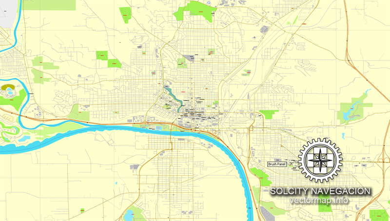
Printable vector maps of Sioux City are much more convenient and efficient than any electronic maps on your smartphone, because ALL DETAILS are displayed in the entire space of Sioux City map.
Useful tips on working with vector maps of cities and countries in Adobe Illustrator.
«V» – launches the Selection tool (cursor, black arrow), which makes active any vector line.
«А» – launches the Direct Selection tool (white cursor), allows you to select curve elements and drag them to the desired place.
«R» – activates the Rotate tool, which helps you rotating selected objects around the center point by 360 degrees.
«E» – gives you the opportunity to use the Eraser tool and erase unnecessary parts.
«X» – switches between Fill and Stroke in the Tools section. Try to get used to this hot key and
you will quickly understand that you can’t live and work without it.
Guides are not limited to vertical and horizontal in Adobe Illustrator. You can also create a diagonal guide for example. Moreover, you can turn any contours into guides. Select the outline and go to View > Guides > Make Guides (Create Guides), or simply press Cmd/Ctrl + 5. You can also turn the guides back into an editable object. Go to menu, View > Guides > Unlock Guides (Release Guides), select the guide you want to edit and select View > Guides > Release Guides (Reset Guides), or just press Cmd/Ctrl + Option / Alt + 5).

You will probably want to change the color scheme used on our Sioux City vector map.
To quickly and effectively play with colors.
Of course, you can do it manually, all objects in our Sioux City vector map are divided according to types and layers, and you can easily change the color gamma of vector objects in groups and layers.
But there is more effective way of working with the whole VECTOR MAP of Sioux City and all layers:
The overview dialog «Edit colors»/«Repaint Graphic Object» (this dialog box name can change depending on the context):
If you have selected a part or a layer of Sioux City vector map and open the dialog box by clicking the icon in the Control panel, on the Samples palette or the Color Catalog, or if you choose Edit > Edit Colors> Repaint Graphic Object, then the «Repaint Graphic Object» dialog box appears, and you get access to «Assign» and «Edit» tabs.
If a picture or a map fragment is not selected, and you open the dialog box by clicking the icon in the Control panel, on the Samples palette or in the Color Catalog, the «Edit Colors» dialog box appears and you can only access the «Edit» tab.
Regardless of the name at the top of the dialog box, the right-hand side always displays the color group of the current document, as well as two default color groups: Print Color and Grayscale. These color groups can be selected and used any time.
Create and edit color groups of Sioux City vector map, and also assign colors using the «Edit Colors»/ а «Repaint Graphic Object» dialog box.
A. Creating and editing of a color group on the «Edit» tab
B. Assigning colors on the «Assign» tab
C. Select a group of colors from the «Color groups» list
The option «Repaint a graphic object» in the lower part of the dialog box allows you to preview the colors on a selected layer of Vector map, or a group of elements, and specify whether its colors will be redefined when the dialog box is closed.
The main areas of the dialog box are:
«Edit»
The «Edit» tab is designed to create a new or edit the existing color groups.
The harmony rules Menu and the Color Wheel are used to conduct experiments with color harmonies. The color wheel shows how colors are related in color harmony, and the color bars allow you to view and manipulate an individual color values. In addition, you can adjust the brightness, add and remove colors, save color groups and view colors on the selected Vector Map of Sioux City or a separated layers.
«Assign»
The «Assign» tab is used to view and control on how the original colors are replaced with colors from the color group like your corporate colors in the Vector Map of Sioux City.
The assign color ability is provided only if the entire map, layer or fragment is selected in the document. You can specify which of new colors replace the current colors, whether the spot colors should be preserved and how colors are replaced (for example, you can replace colors completely or changing the color tone while maintaining the brightness). The «Assign» tab allows you to redefine colors in the Vector Map of Sioux City, or in separate layers and fragments using the current color group or reducing the number of colors in the current Vector Map.
Color groups
Is a list of all saved color groups for current document (the same groups appear in the «Samples» palette). You can edit and delete the existing color groups, as well as creating a new ones using the list of “Color Groups” in the dialog box. All changes appear in the «Samples» palette.
The highlighted color group shows, which color group is currently edited.
Sioux City is at the navigational head, or the most upstream point to which general cargo ships can travel, of the Missouri River, about 95 miles (153 km) north of the Omaha–Council Bluffs metropolitan area. Sioux City and the surrounding areas of northwestern Iowa, northeastern Nebraska and southeastern South Dakota are sometimes referred to as Siouxland, especially by local media and residents.
Any color group can be selected and edited, or used to redefine the colors in the selected vector map of Sioux City , its fragments or elements.
Saving a color group adds this group to the specified list.
Opening the «Edit Colors»/«Repaint Graphic Object» dialog box.
Open the «Edit Colors»/«Repaint Graphic Object» dialog box using one of the following methods:
«Edit»> «Edit Colors»> «Repaint Graphic object» or «Repaint With Style».
Use these commands if you need to edit the colors in the selected vector map of Sioux City.
«Repaint Graphic object» button on the «Control» panel.
Use this button if you need to adjust colors of Sioux City vector map using the а «Repaint graphic object» dialog box.
The specified button is available if the selected vector map or its fragment contains two or more colors.
Note. This color editing method is convenient for global color adjustment in a vector map, if global colors were not used when creating a Map of Sioux City.
The «Edit colors» button or «Edit or apply colors» on the «Color Catalog» palette
Click this button if you need to edit colors on the «Color Catalog» palette or edit and then apply them to the selected Vector Map of Sioux City or its fragment.
The «Edit color group» button or «Edit or apply color group» on the «Samples» palette.
Click this button if you need to edit the colors in the specific color group or edit and apply them to the selected Vector Map of Sioux City or a group of its elements, for example, the whole layer “Streets and lines”. You can also double-click the color group in the Samples panel to open the dialog box.
If the map file is too large and your computer freezes or even can’t open it quickly:
1. Try to reduce the color resolution of the video card (display) to 256 colors while working with a large map.
2. Using Windows Task Manager, select all the application you don’t need, while working with map, just turn them off.
3. Launch Adobe Illustrator. (DO NOT OPEN the vector map file)
4. Start the Windows Task Manager using administrator rights > Find the “Illustrator” process > set the «real time» priority,
5. Open the file. When you see the LEGACY FONT popup window – click “OK” (do not update). You can restore the TEXT later.
6. Can also be useful: When file is opened – Edit > Settings > Basic Settings > disable smoothing. /// It looks scary, but works quickly)))
We recommend saving the file in Adobe Illustrator 10 version. It’s much more stable when working with VERY BIG size files.
It is also a part of the Sioux City Designated Market Area (DMA), a larger media market region that covers parts of four states and has a population of 1,043,450.
Geography
Sioux City is located at 42°29′53″N 96°23′45″W (42.497957, −96.395705). Sioux City is at an altitude of 1,135 feet (345.9 m) above sea level. Sioux City boarders two states, those of which are South Dakota to the West-Northwest, and Nebraska to the west. According to the United States Census Bureau, the city has a total area of 58.49 square miles (151.49 km2), of which, 57.35 square miles (148.54 km2) is land and 1.14 square miles (2.95 km2) is water.
Parks and recreation
Stone State Park is in the northwest corner of the city, overlooking the South Dakota/Iowa border. Stone Park is near the northernmost extent of the Loess Hills, and is at the transition from clay bluffs and prairie to sedimentary rock hills and bur oak forest along the Iowa side of the Big Sioux River. The park is used by picnickers, day hikers, and for mountain biking.
Dorothy Pecaut Nature Center is a destination nature preserve for Woodbury County, and is located within the boundaries of Stone State Park. The butterfly garden is unique to the area; wild turkeys and white-tail deer are commonly sighted from the well-marked trails.
Downtown entertainment venues include the Hard Rock Hotel & Casino, the 10,000-seat Tyson Event Center/ Gateway Arena, Sioux City Orpheum Theatre, Promenade Cinema 14 and the Anderson Dance Pavilion which overlooks the Missouri River.
Pulaski Park is named for the Polish General Kazimierz Pułaski, who fought in the American Revolution. This park features baseball diamond facilities, and is located in western Morningside along old U.S. Highway 75 (South Lewis Blvd.). It is largely built on the filled lakebed of Half Moon Lake, which was originally created in the 1890s by the excavation of fill dirt to build the approaches for the iron railroad bridge spanning the Missouri near the stockyards. The neighborhood on the bluff overlooking the park was historically settled by Lithuanian and Polish immigrants, many of whom worked in the meatpacking industry during the early 20th century.
Latham Park is located in a residential area of Morningside, and is the only privately owned and maintained open-to-the-public park within the city limits. It was left in trust in 1937 under the terms of Clara Latham’s will; her family had built the house on 1-acre (4,000 m2) of ground in 1915. The house and grounds are currently being restored by the Friends of Latham Park.
First Bride’s Grave is tucked in a corner pocket of South Ravine Park, lies a series of paths, trails, and steps leading to the grave of the First Bride of Sioux City, Rosalie Menard. She was the first bride of a non-Native American to be wed in Sioux City, Iowa, thus receiving her title.
War Eagle Park is named for the Yankton Sioux chief Wambdi Okicize (d. 1851) who befriended early settlers. A monument overlooks the confluence of the Big Sioux and Missouri Rivers. The sculpture represents the chief in his role as a leader and peacemaker, wearing the eagle feather bonnet and holding the ceremonial pipe.
Riverside Park is located on the banks of the Big Sioux River. One of the oldest recreational areas of the city, it is home to the Sioux City Boat Club and Sioux City Community Theater. The park is on land that once belonged to the first white settler in the area, Théophile Bruguier; his original cabin is preserved in the park.
Bacon Creek Park is located northeast of Morningside and features a scenic walking trail, dog park, picnic shelters, and playground equipment.
Golf courses, city parks, and aquatics: Sioux City is also home to several municipal public golf courses, including Floyd Park in Morningside, Green Valley near the Southern Hills, Sun Valley on the northern West Side, and Hidden Acres in nearby Plymouth County. Sioux City also has a number of private golf clubs, including Sioux City Country Club, and Whispering Creek Golf Club. The city has over 1,132 acres (5 km2) of public parkland located at 53 locations, including the riverfront and many miles of recreation trails. Five public swimming pools/aquatics centers are located within Sioux City neighborhoods.
Small guide: How to work with the vector map?
You can: Mass select objects by type and color – for example, the objects type “building” (they are usually dark gray) – and remove them from the map, if you do not need them in your print or design project. You can also easily change the thickness of lines (streets), just bulk selection the road by the line color.
The streets are separated by type, for example, type “residential road” are usually white with a gray stroke. Highway usually orange with a brown or dark gray stroke.
It is easy to change the font of inscriptions, all or each individually. Also, just can be make and any other manipulation of objects on the vector map in Adobe illustrator format.
Important: All the proportions on the map are true, that is, the relative sizes of the objects are true, because Map is based on an accurate GPS projection, and It transated into the (usual for all) the Mercator projection.
You can easily change the color, stroke and fill of any object on the map, zoom without loss of quality Image Verification.
Select object

Bulk selection the same objects on the vector map

See the bulk selected objects on the vector map

Bulk delete buildungs from the vector map

Select residencial road (small street) on the vector map

Bulk selection the same lines (streets, roads) on the full map

Create fat lines of the streets on the vector maps (bulk action) 1

Create fat lines of the streets on the vector maps (bulk action) 2

Create fat lines of the streets on the vector maps (bulk action) 3

You can easily change the color, stroke and fill of any object on the map, zoom without loss of quality Image Verification.

 Author: Kirill Shrayber, Ph.D. FRGS
 in layers")


