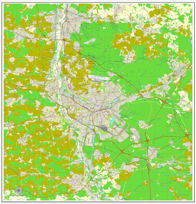
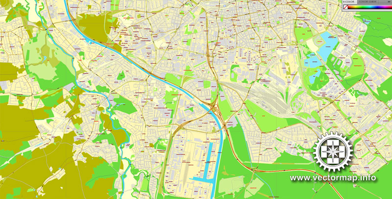
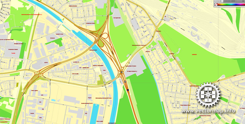
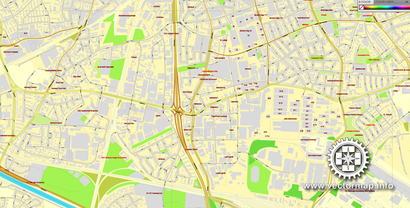
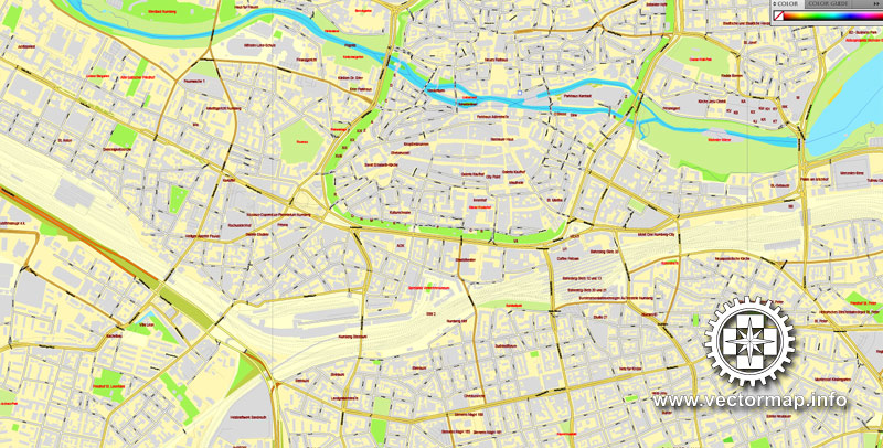
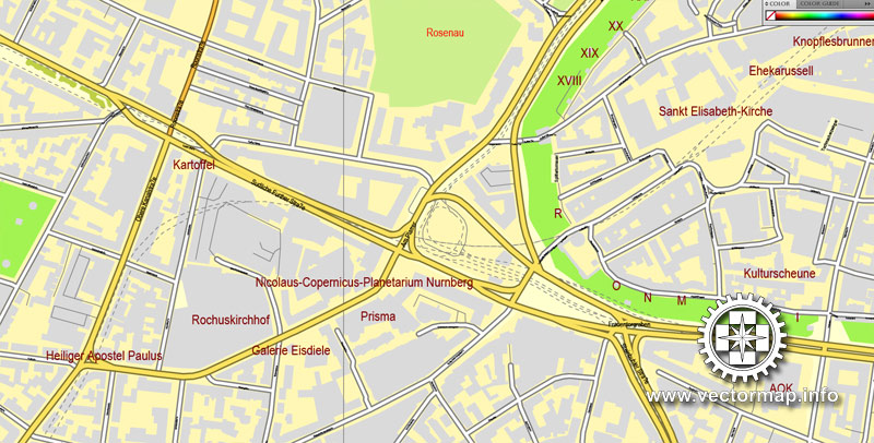
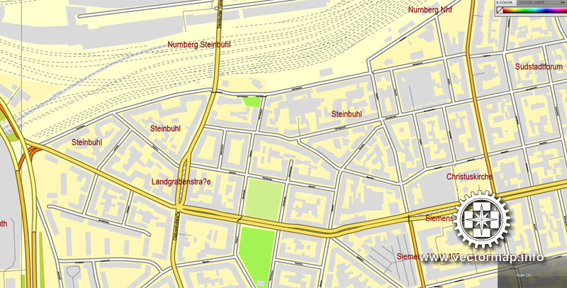
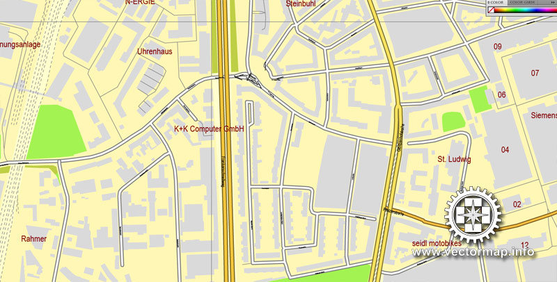
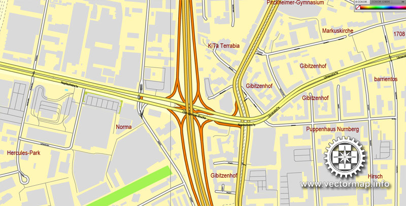
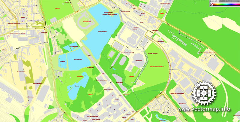
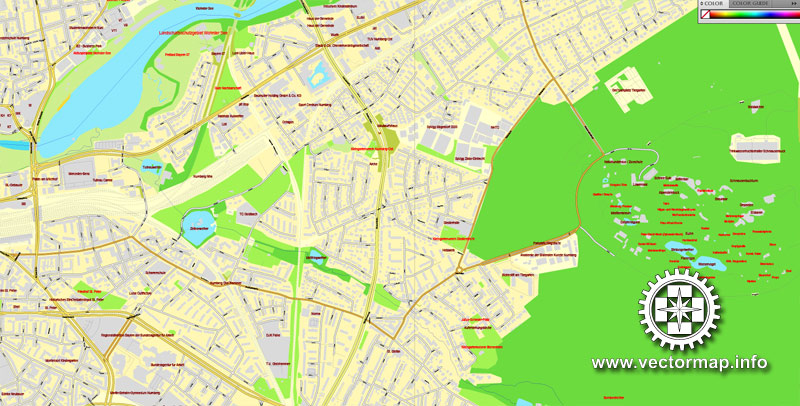
Nuremberg, Germany, printable vector street map, exact City Plan V.3 full editable, Adobe PDF, full vector, scalable, editable, text format street names, 50 mb ZIP
All streets, All buildings.
Map for design, printing, publications, arts, projects, presentations, for architects, designers and builders, business, logistics. The most exact and detailed map of the city.
You can edit this file by Adobe Illustrator, Adobe Acrobat, Corel Draw.
Different font colors of the street names (black); object names by type (brown, red).
DXF, DWG, CDR and other formats – on request, same price, please, contact
Nuremberg, Germany.
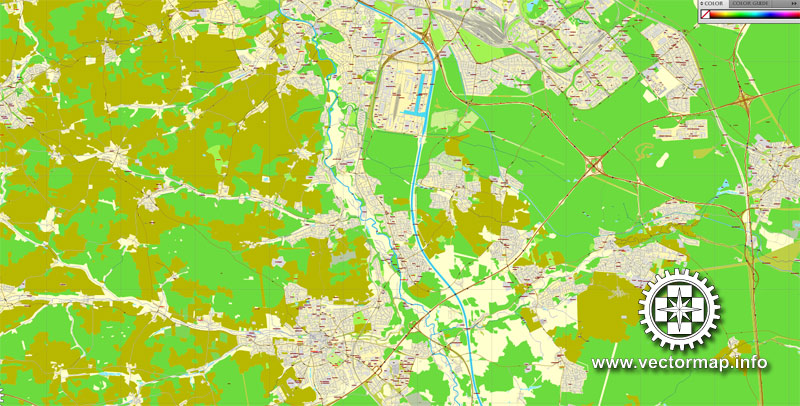
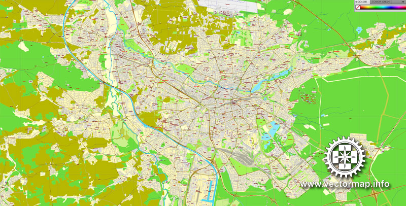
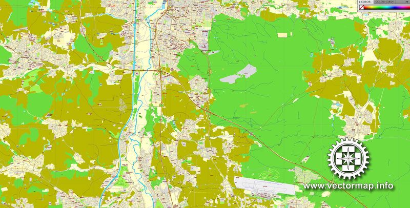
This vector map of Nuremberg is used as a basis for design, editing, and further printing.
This is the most detailed, exact map of Nuremberg for high-quality printing and polygraphy. You can always clarify the map development date by contacting us.
For your convenience, all objects on Nuremberg vector map are divided into layers. And the editing is very easy – colors, lines, etc.
You can easily add any objects needed (e.g. shops, salons, sale points, gas station or attraction) on any layer of Nuremberg vector map.
Nuremberg is the second-largest city of the German federal state of Bavaria after its capital of Munich, and its 511,628 (2016) inhabitants make it the 14th largest city of Germany. On the Pegnitz River (from its confluence with the Rednitz in Fürth onwards: Regnitz, a tributary of the River Main) and the Rhine–Main–Danube Canal, it lies in the Bavarian administrative region of Middle Franconia, and is the largest city and the unofficial capital of Franconia. Nuremberg forms a continuous conurbation with the neighbouring cities of Fürth, Erlangen and Schwabach with a total population of 787,976 (2016), while the larger Nuremberg Metropolitan Region has approximately 3.5 million inhabitants. The city lies about 170 kilometres (110 mi) north of Munich. It is the largest city in the East Franconian dialect area (colloquially: “Franconian”; German: Fränkisch).
One of the advantages of Nuremberg vector maps of our production is the relevance of cartographic data, we constantly update all our products.
This vector map of Nuremberg is used by:
designers, layout designers, printers, advertisers and architects. Our product – vector maps – is designed for further editing and printing in large formats – from @Wall format (a few meters) to A-0 and A-1, A-2, A-3.
Nuremberg map in vector format is used for design, urban planning, presentations and media visualizations.
Advertising and presentation map of Nuremberg (usually the final designer marks the routes, and puts the client’s objects (shops, saloons, gas stations etc.)
The undoubted advantage is that people will NEVER throw out this advertising product – the map. In fact, as an advertising medium, a map is the most “long-playing” of the well-known polygraphic advertising media, with the longest lifespan, and the maximum number of interactions with the customer.
For travelers, maps are sold at the airports and gas stations around the world. Often the source is our vector maps.
Take a look, who purchases our vector maps of Nuremberg in “Our Clients and Friends” page – these are large and small companies, from super-brands like Volvo and Starbucks, to small design studios and printing houses.
It’s very easy to work with vector maps of Nuremberg, even for a not very experienced designer who can turn on and off the map layers, add new objects, change the colors of fill and lines according to customer requirements.
The undoubted advantage of Nuremberg vector maps in printing is an excellent and detailed visualization, when customer can expand a large paper map and instantly define his location, find a landmark, an object or address on map, unlike using the popular electronic formats of Google and Yandex maps for example.
Printable vector maps of Nuremberg are much more convenient and efficient than any electronic maps on your smartphone, because ALL DETAILS are displayed in the entire space of Nuremberg map.
Useful tips on working with vector maps of cities and countries in Adobe Illustrator.
«V» – launches the Selection tool (cursor, black arrow), which makes active any vector line.
«А» – launches the Direct Selection tool (white cursor), allows you to select curve elements and drag them to the desired place.
«R» – activates the Rotate tool, which helps you rotating selected objects around the center point by 360 degrees.
«E» – gives you the opportunity to use the Eraser tool and erase unnecessary parts.
«X» – switches between Fill and Stroke in the Tools section. Try to get used to this hot key and
you will quickly understand that you can’t live and work without it.
Guides are not limited to vertical and horizontal in Adobe Illustrator. You can also create a diagonal guide for example. Moreover, you can turn any contours into guides. Select the outline and go to View > Guides > Make Guides (Create Guides), or simply press Cmd/Ctrl + 5. You can also turn the guides back into an editable object. Go to menu, View > Guides > Unlock Guides (Release Guides), select the guide you want to edit and select View > Guides > Release Guides (Reset Guides), or just press Cmd/Ctrl + Option / Alt + 5).
You will probably want to change the color scheme used on our Nuremberg vector map.
To quickly and effectively play with colors.
Of course, you can do it manually, all objects in our Nuremberg vector map are divided according to types and layers, and you can easily change the color gamma of vector objects in groups and layers.
But there is more effective way of working with the whole VECTOR MAP of Nuremberg and all layers:
The overview dialog «Edit colors»/«Repaint Graphic Object» (this dialog box name can change depending on the context):
If you have selected a part or a layer of Nuremberg vector map and open the dialog box by clicking the icon in the Control panel, on the Samples palette or the Color Catalog, or if you choose Edit > Edit Colors> Repaint Graphic Object, then the «Repaint Graphic Object» dialog box appears, and you get access to «Assign» and «Edit» tabs.
If a picture or a map fragment is not selected, and you open the dialog box by clicking the icon in the Control panel, on the Samples palette or in the Color Catalog, the «Edit Colors» dialog box appears and you can only access the «Edit» tab.
Regardless of the name at the top of the dialog box, the right-hand side always displays the color group of the current document, as well as two default color groups: Print Color and Grayscale. These color groups can be selected and used any time.
Create and edit color groups of Nuremberg vector map, and also assign colors using the «Edit Colors»/ а «Repaint Graphic Object» dialog box.
A. Creating and editing of a color group on the «Edit» tab
B. Assigning colors on the «Assign» tab
C. Select a group of colors from the «Color groups» list
The option «Repaint a graphic object» in the lower part of the dialog box allows you to preview the colors on a selected layer of Vector map, or a group of elements, and specify whether its colors will be redefined when the dialog box is closed.
The main areas of the dialog box are:
«Edit»
The «Edit» tab is designed to create a new or edit the existing color groups.
The harmony rules Menu and the Color Wheel are used to conduct experiments with color harmonies. The color wheel shows how colors are related in color harmony, and the color bars allow you to view and manipulate an individual color values. In addition, you can adjust the brightness, add and remove colors, save color groups and view colors on the selected Vector Map of Nuremberg or a separated layers.
«Assign»
The «Assign» tab is used to view and control on how the original colors are replaced with colors from the color group like your corporate colors in the Vector Map of Nuremberg.
The assign color ability is provided only if the entire map, layer or fragment is selected in the document. You can specify which of new colors replace the current colors, whether the spot colors should be preserved and how colors are replaced (for example, you can replace colors completely or changing the color tone while maintaining the brightness). The «Assign» tab allows you to redefine colors in the Vector Map of Nuremberg, or in separate layers and fragments using the current color group or reducing the number of colors in the current Vector Map.
Color groups
Is a list of all saved color groups for current document (the same groups appear in the «Samples» palette). You can edit and delete the existing color groups, as well as creating a new ones using the list of “Color Groups” in the dialog box. All changes appear in the «Samples» palette.
The highlighted color group shows, which color group is currently edited.
There are many institutions of higher education in the city, most notably the University of Erlangen-Nuremberg (Friedrich-Alexander-Universität Erlangen-Nürnberg), with 39,780 students (2017) Bavaria’s third and Germany’s 11th largest university with campuses in Erlangen and Nuremberg and a university hospital in Erlangen (Universitätsklinikum Erlangen); Technische Hochschule Nürnberg Georg Simon Ohm; and Hochschule für Musik Nürnberg. Nuremberg Airport (Flughafen Nürnberg „Albrecht Dürer“) is the second-busiest airport of Bavaria after Munich Airport, and the tenth-busiest airport of Germany.

Any color group can be selected and edited, or used to redefine the colors in the selected vector map of Nuremberg , its fragments or elements.
Saving a color group adds this group to the specified list.
Opening the «Edit Colors»/«Repaint Graphic Object» dialog box.
Open the «Edit Colors»/«Repaint Graphic Object» dialog box using one of the following methods:
«Edit»> «Edit Colors»> «Repaint Graphic object» or «Repaint With Style».
Use these commands if you need to edit the colors in the selected vector map of Nuremberg.
«Repaint Graphic object» button on the «Control» panel.
Use this button if you need to adjust colors of Nuremberg vector map using the а «Repaint graphic object» dialog box.
The specified button is available if the selected vector map or its fragment contains two or more colors.
Note. This color editing method is convenient for global color adjustment in a vector map, if global colors were not used when creating a Map of Nuremberg.
The «Edit colors» button or «Edit or apply colors» on the «Color Catalog» palette
Click this button if you need to edit colors on the «Color Catalog» palette or edit and then apply them to the selected Vector Map of Nuremberg or its fragment.
The «Edit color group» button or «Edit or apply color group» on the «Samples» palette.
Click this button if you need to edit the colors in the specific color group or edit and apply them to the selected Vector Map of Nuremberg or a group of its elements, for example, the whole layer “Streets and lines”. You can also double-click the color group in the Samples panel to open the dialog box.
If the map file is too large and your computer freezes or even can’t open it quickly:
1. Try to reduce the color resolution of the video card (display) to 256 colors while working with a large map.
2. Using Windows Task Manager, select all the application you don’t need, while working with map, just turn them off.
3. Launch Adobe Illustrator. (DO NOT OPEN the vector map file)
4. Start the Windows Task Manager using administrator rights > Find the “Illustrator” process > set the «real time» priority,
5. Open the file. When you see the LEGACY FONT popup window – click “OK” (do not update). You can restore the TEXT later.
6. Can also be useful: When file is opened – Edit > Settings > Basic Settings > disable smoothing. /// It looks scary, but works quickly)))
We recommend saving the file in Adobe Illustrator 10 version. It’s much more stable when working with VERY BIG size files. This vector map of Nuremberg is used as a basis for design, editing, and further printing.
This is the most detailed, exact map of Nuremberg for high-quality printing and polygraphy. You can always clarify the map development date by contacting us.
For your convenience, all objects on Nuremberg vector map are divided into layers. And the editing is very easy – colors, lines, etc.
You can easily add any objects needed (e.g. shops, salons, sale points, gas station or attraction) on any layer of Nuremberg vector map.
Staatstheater Nürnberg is one of the five Bavarian state theatres, showing operas, operettas, musicals, and ballets (main venue: Nuremberg Opera House), plays (main venue: Schauspielhaus Nürnberg), as well as concerts (main venue: Meistersingerhalle). Its orchestra, Staatsphilharmonie Nürnberg, is Bavaria’s second-largest opera orchestra after the Bavarian State Opera’s Bavarian State Orchestra in Munich. Nuremberg is the birthplace of Albrecht Dürer and Johann Pachelbel (Canon in D).
Nuremberg was the site of major Nazi rallies, and it provided the site for the Nuremberg trials, which held to account many major Nazi officials.
Geography and climate
Several old villages now belong to the city, for example Grossgründlach, Kraftshof, Thon, and Neunhof in the north-west; Ziegelstein in the northeast, Altenfurt and Fischbach in the south-east; and Katzwang, Kornburg in the south. Langwasser is a modern suburb.
Nuremberg has a humid continental climate (Köppen: Dfb) bordering on an oceanic climate (Köppen: Cfb). The city’s climate is influenced by its inland position and higher altitude. Winters are changeable, with either mild or cold weather: the average temperature is around −3 °C (27 °F) to 4 °C (39 °F), while summers are generally warm, mostly around 13 °C (55 °F) at night to 25 °C (77 °F) in the afternoon. Precipitation is evenly spread throughout the year, although February and April tend to be a bit drier whereas July tends to have more rainfall.
Nuremberg
City in Germany
Nuremberg, a city in Bavaria, is distinguished by its medieval architecture, including the fortifications and stone towers of its Altstadt (Old Town). At the northern edge of the Altstadt, surrounded by red-roofed buildings, stands Kaiserburg Castle. The Hauptmarkt (central square) contains the Schöner Brunnen, the gilded “beautiful fountain” with tiers of figures, and Frauenkirche, a 14th-century Gothic church.
Population: 495,121 (2013) UNdata
Administrative region: Middle Franconia
Nuremberg is a city on the river Pegnitz and the Rhine–Main–Danube Canal in the German state of Bavaria, in the administrative region of Middle Franconia, about 170 kilometres (110 mi) north of Munich. It is the second-largest city in Bavaria (after Munich), and the largest in Franconia (Franken). The population as of February 2015, is 517,498, which makes it Germany’s fourteenth-largest city. The urban area also includes Fürth, Erlangen and Schwabach with a total population of 763,854. The “European Metropolitan Area Nuremberg” has ca. 3.5 million inhabitants.
Source Wiki

Free vector map World, Adobe Illustrator, download now maps vector clipart Map for design, projects, presentation free to use as you like. World map vector, Vector world map, World vector map, Map western europe, West europe maps, Map of the world modifiable, High resolution world map, World map illustrator, World map PDF editable, World vector map download,
Free vector map World, Adobe Illustrator, download now maps vector clipart
Map for design, projects, presentation free to use as you like.
Free Download All World Vector Maps here >>>>>
See also: TERMS & CONDITIONS: SOFTWARE LICENSE AGREEMENT FOR DIGITAL CARTOGRAPHIC DATA
Small guide: How to work with the vector map?
You can: Mass select objects by type and color – for example, the objects type “building” (they are usually dark gray) – and remove them from the map, if you do not need them in your print or design project. You can also easily change the thickness of lines (streets), just bulk selection the road by the line color.
The streets are separated by type, for example, type “residential road” are usually white with a gray stroke. Highway usually orange with a brown or dark gray stroke.
All objects are divided by types: different types of roads and streets, polygons of buildings, landfills, urban areas, parks and more other.
It is easy to change the font of inscriptions, all or each individually. Also, just can be make and any other manipulation of objects on the vector map in Adobe illustrator format.
Important: All the proportions on the map are true, that is, the relative sizes of the objects are true, because Map is based on an accurate GPS projection, and It transated into the (usual for all) the Mercator projection.
You can easily change the color, stroke and fill of any object on the map, zoom without loss of quality Image Verification.
Select object

Bulk selection the same objects on the vector map

See the bulk selected objects on the vector map

Bulk delete buildungs from the vector map

Select residencial road (small street) on the vector map

Bulk selection the same lines (streets, roads) on the full map

Create fat lines of the streets on the vector maps (bulk action) 1

Create fat lines of the streets on the vector maps (bulk action) 2

Create fat lines of the streets on the vector maps (bulk action) 3

You can easily change the color, stroke and fill of any object on the map, zoom without loss of quality Image Verification.

 Author: Kirill Shrayber, Ph.D. FRGS

